
크라플라 여행 가이드

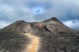
Krafla is a caldera, part of a greater volcanic system of the same name, located north of Lake Mývatn in North Iceland. It is one of the country’s most explosive volcanoes, having gone off approximately 29 times since the country was first settled.
Discover more about the Northern region of Iceland on a tour from Akureyri.
Photo above from Wikimedia, Creative Commons, by Earthquakes Krafla. No edits made.
Proportions of Krafla
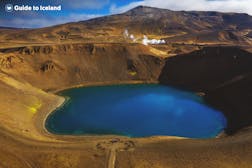
The crater of Krafla’s caldera is about ten kilometres (seven miles) wide, although its fissure zone extends for 90 kilometres (56 miles). The Víti crater is located in this fissure zone, famed for the green lake within it.
At its tallest, the peak of Krafla is 818 metres (2684 feet) high.
Major Eruptions at Krafla
With 29 eruptions under its belt since settlement, Krafla has long had a reputation as an unpredictable and dangerous feature. Two, however, were more significant then the rest.
The Mývatn Fires were the first of these. Continuing for five years from 1724 to 1729, the fissure erupted across much of its length, and sent lava fountains so high in the air that they could be seen all the way across the Highlands, on the South Coast.
No one was killed directly by this eruption, although considering the ash and toxic fumes, it is difficult to be certain of how many indirectly died. It did, however, destroy three farms.
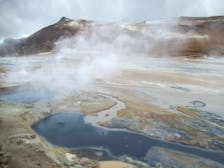
The second major eruptive episode at Krafla occurred between 1975 and 1984. Nine separate eruptions occurred, limiting services, industry and tourism in the area, and dramatically changing it.
For example, the hot spring of Grjótagjá was accessible prior to the eruption, but the temperature is now incredibly volatile.
 Photo from Wikimedia, Creative Commons, by Christian Wirth
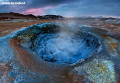
Utilisation of Krafla’s Energy
Since 1977, surprisingly established during an eruptive episode, a power station has existed at Krafla, helping the north with its green energy needs. Since then, there have been further attempts to harness its incredible power potential.
The most notable of these was a survey taken in 2006 that revealed a vast amount of lava just below the surface of the earth. This led to the creation of the Icelandic Deep Drilling Project’s first well, which discovered liquid rock a mere two kilometres (just over a mile) beneath the earth’s surface.
Surroundings of Krafla
Krafla is blessed with an incredible location, meaning visits to it can be accompanied by lots of different sites. This is because it sits in the Lake Mývatn area of the north, which is renowned for its diversity.
The lake itself, or, more correctly, the lakes themselves, are beautiful and serene, with dozens of species of nesting bird, fascinating flora and a wealth of geological sites. Amongst these, the Dimmuborgir lava fortress is the most impressive.
Krafla is also relatively close to the most powerful waterfall in Europe, Dettifoss, and an incredibly verdant horseshoe-shaped canyon, Ásbyrgi.
Reykjahlið is the closest settlement to Krafla, though small and with few services. The towns of Akureyri and Husavík, however, are still relatively close, and perfect for refreshment and rest.
The former is the largest settlement outside of the Reykjavík area, whereas the latter is often called the whale-watching capital of Europe.


아이슬란드 최대의 여행 마켓플레이스를 휴대폰에 다운로드하여 전체 여행을 한 곳에서 관리하세요
휴대폰 카메라로 이 QR 코드를 스캔하고 나타나는 링크를 누르면 아이슬란드 최대 여행 시장이 내 손 안에! 다운로드 링크가 포함된 SMS나 이메일을 받으려면 전화번호나 이메일 주소를 추가하세요


