
The amazing Mt. Kerlingarfjöll, a fascinating Hike through Hveradalir, and the Kjölur Route


I have visited many of Iceland's geothermal areas over the years, as there is something so otherworldly about hiking amongst boiling mud pools, hissing vents and spouting geysers. Not to mention the extraordinary geothermal colours.
But there is one geothermal area in particular that blows my mind, and that is the Hveradalir geothermal area in Mt. Kerlingarfjöll in the highland of Iceland, which is one of the largest high-temperature geothermal areas in Iceland.
Top photo: Hiking in Mt. Kerlingarfjöll
 Hiking in Mt. Kerlingarfjöll and Hveradalir
In the highland of Iceland, you will find several mind-blowing spots, and the Mt. Kerlingarfjöll area is for sure one of the pearls of the highland of Iceland. In August 2020 this spectacular area (344 km2) was declared protected.
Mt. Kerlingarfjöll is a huge mountain range some 6-700 meters above sea level and nestled between two glaciers, Langjökull and Hofsjökull, Iceland's 2nd and 3rd largest glaciers.
The mountain range is divided in two by the rivers Ásgarðsá and Kisa; the east and west mountains.
A Visit to the Ice Cave Tunnel in Langjökull Glacier in Iceland - Into the Glacier
 Hiking in Hveradalir
In the steaming geothermal valley, Hveradalir, you will find solfataras and mud pots in abundance, and the whole area is boiling and hissing.
I am sure that visiting this high-temperature geothermal area will leave no man untouched; it at least had a great impact on me.
Several trails lead through the geothermal area, and you can take both long and short hikes here. I have only taken a short hike in Hveradalir as I am not much of a hiker, but what a hike this was!
If you plan on going on longer hikes then always leave your itinerary at Safetravel.is.
Hiking boots and warm clothing are necessary for this hike, as here we are high up and there can be sudden weather changes. It was pretty cold during my August visits, and you can hear the wind howling in my videos.
Geothermal areas are at their most beautiful in the sunshine when the geothermal colours become extra bright and vivid. Unfortunately, it hasn't been sunny during any of my visits to Mt. Kerlingarfjöll.
But you can see such sunny photos if you click on the links of my other travel-blogs on geothermal areas at the end of this travel-blog.
 A huge steaming hill in Hveradalir - I love this photo
In Hveradalir you will find wooden steps and wooden bridges and you can follow the trails you see in the surrounding hills.
The whole area is bubbling and boiling and it is both amazing and a little scary hiking in this area, seeing the forces of nature in action.
Rhyolite mountains, glaciers, and a hissing landscape in ranges of yellow, orange, red, and green colours will greet you in Hveradalir.
I even saw a small green river flowing down one of the rhyolite mountains. The perfect colour match in such rhyolite mountains is the yellow rhyolite and the black obsidian.
 Steps leading down to the geothermal area from the parking lot; are not for those who suffer from a fear of heights!
Hveradalir - the Hot Spring Valleys is such a fascinating area of Iceland and here you can take spectacular photos.
I love the photos which show the whole area from above with tiny people hiking in this amazing landscape.
Here you can also photograph beautiful details when you explore the smaller aspects of the geothermal areas and the interesting geology of Iceland.
 A green creek runs into the river at Hveradalir
Geologists must have a field day exploring the geothermal areas of Hveradalir.
And of course, Mt. Kerlingarfjöll is on the Natural Heritage Register and is now finally protected.
The ground here is unstable and rich in clay and cannot withstand too much traffic, so make sure to stay on the marked trails.
 The river Innri-Ásgarðsá runs calmly through the bubbling and boiling geothermal area. Contemplating where to go next...
Straying from the trails is very dangerous as the thin crust can by hiding boiling hot water, which you might accidentally step through.
Also, never step on coloured areas with deposits as they are extremely hot! Accidents have been known to happen in geothermal areas, and such accidents will result in severe burns, where the skin rolls off the foot like plastic or pantyhose!
 A bubbling and boiling hot spring at Hveradalir
My mother witnessed such an accident when she was visiting a geothermal area as a young girl.
A man accidentally stepped through a thin crust of clay and into a boiling hot spring.
She told me that it is stuck in her mind how the skin on the poor man's foot immediately rolled off.
 Beautiful geothermal colours by the hot river
This story has also stuck with me so I am always extra careful when visiting the geothermal areas in Iceland. And even a bit scared to be surrounded by so much boiling water.
Accidents have also happened here in Hveradalir, so wooden paths and bridges were added back in 2014 to make this area safer for visitors.
 Hiking in Hveradalir
There were quite a few people visiting Hveradalir when I hiked through this area, and I was a bit concerned about their safety, hoping that they all realized that you have to stay on the trails and never go closer to a beautiful spot of geothermal colours to get a better photo.
The Hverabotn geothermal area further on, is the site of the highest surface temperature measured in Iceland; a whopping 150 degrees C!
Hveradalir cuts Mt. Kerlingarfjöll in half so to speak.
The rhyolite Mt. Kerlingarfjöll got its name from a troll woman, Kerling, a huge pillar of palagonite rock, around 25 meters tall.
Kerling in Icelandic is both a derogatory name for an old woman, but also a troll woman.
 Mt. Kerlingarfjöll in the evening sun
You will find many pillars of rock in Iceland which go by the name Kerling and connected to them are invariably old troll stories.
As we all know then trolls turn to stone when they see daylight and these pillars of rock are trolls, which weren't able to seek shelter before sunrise.

Hiking in Hveradalir
According to the information sign by Mt. Kerlingarfjöll, this particular Kerling might have been the daughter of the fire-giant Surtur in the Surtshellir Cave from Norse mythology. But I haven't been able to find the source for this folklore.
See also:
Kerlingarskarð Pass in Snæfellsnes in West-Iceland - the Folklore of the Giantess & her Fiancé
My favourite Caves in Iceland if you want to see what the massive Surtshellir cave looks like and why I don't visit it anymore
I haven't got a photo of the Kerling rock, but show you a photo of one of the tallest peaks of Mt. Kerlingarfjöll instead, the distinctive Loðmundur. The other tallest peaks are Snækollur and Fannborg.
 Loðmundur in the pink summer sun on a chilly August night
It is possible to stay overnight in Hálendismiðstöðin, the Mountain Resort Ásgarður in Mt. Kerlingarfjöll in the summertime. There you will both find a camping site and sleeping accommodations inside.
A mountain hut was built in Kerlingafjöll back in 1938. Here a very popular skiing school was established back in 1961, and from 1961-2000 there were organized ski trips to Mt. Kerlingarfjöll.
 The Mountain Resort
Since the year 2000, it has not been possible to ski in this area due to climate changes and other travel services have operated at Kerlingarfjöll.
The river Innri-Ásgarðsá runs through here, and the mountain resort gets its electricity from the Sælufoss hydropower plant, which was built back in 1970 and overhauled in 2009.
 Ásgarður in the evening sun back in 2014
Ásgarður is at a 10 km distance from Kjalvegur on road F-347. You can drive to Ásgarður on a gravel road in a 2WD (maybe not the smallest ones), but the last part of the road, which leads up to Mt. Kerlingarfjöll is passable by a 4x4. It is a very rough and steep road.
I have read that the hike is 3 km if you hike from Ásgarður, but we drove to the top in a 4x4 jeep and left our car in the parking lot. On top, you will find a path, which leads to a steep path with steps leading down to Hveradalir. And this is where I started and ended my hike.
 Snow formations in the liking of Casper the Ghost in the mountains
One of the reasons why I finally bought a 4x4 jeep in the summer of 2018, was to be able to visit Hveradalir geothermal area, i.e. to drive to the very top.
And to visit Hvítserkur waterfall, which had been on my list of places to visit for several years:
The majestic Waterfall Hvítserkur in Fitjaá River in West-Iceland
 The gorge is extraordinary
By road F-347 you will see ruggedly beautiful gorges; colourful and plain gorgeous. It is this rugged beauty that touches my heart so much on my travels in Iceland.
There are some spots by the road, where you can park your car and have a look at these gorges.
Jökulfall glacial river and Gýgjarfoss waterfall
 Gýgjarfoss waterfall in Jökulfall glacial river
Driving along road F-347 you will pass a beautiful small glacial waterfall next to the road. This is Gýgjarfoss waterfall in Jökulfall (Jökulkvísl) glacial river.
Jökulfall originates in Hofsjökull glacier and further south it merges with the massive Hvítá glacial river, just after Hvítá runs from Lake Hvítárvatn.
 Gýgjarfoss with a rainbow beautifully lit up by the evening sun
Hvítá originates in Langjökull glacier, Iceland's second-largest glacier.
Together these rivers contribute to the masses of glacial water which creates Gullfoss waterfall, Iceland's best-known waterfall, which gives a name to the Golden Circle.
 Blákvísl - Blue branch river
This beautiful blue river in my photo above is called Blákvísl or Blue branch river. Right by Gýgjarfoss waterfall, Blákvísl river joins Jökulfall glacial river from a gorge guarded by a troll.
It joins Gýgjarfoss and makes up the smallest part of the waterfall.
You can see how it joins Jökulfall glacial river and the waterfall to the left in my photo below.
 Gýgjarfoss waterfall and Kerlingarfjöll
Further up the glacial river, you will find the small waterfall Hvinur, which means a loud swish or a roar.
I stepped out of the car and walked down to the waterfall where I took the photo below. The gorge is small but ruggedly beautiful here.
 Hvinur waterfall in Jökulfall glacial river is right under the bridge
Kjölur is the name of the wide mountain pass between Langjökull and Hofsjökull glaciers and Kjalvegur road connects South and North Iceland.
Most visitors to Iceland visit the popular Golden Circle but don't go further than the Gullfoss waterfall. That is where Kjalvegur starts.
See also:
A selection of the Golden Circle Tours - the most popular sightseeing tour in Iceland
Kjalvegur road
 Mt. Kerlingarfjöll on road F347 as seen from Kjalvegur road
Seeing that this is the highland and interior of Iceland, and Kjölur is 6-700+ meters above sea level, then Kjalvegur road is only open for a few months in the summertime, i.e. late June until the end of September.
Thus, in the wintertime, it is only accessible by super jeeps. When it is closed an impassable sign will be put on the road above Gullfoss waterfall.
Never pass an impassable sign in the wintertime. It has happened on a couple of occasions that tourists have passed this sign in a small car in the wintertime and had to be rescued :(
 Kjölur and Hofsjökull glacier - an ice cap that looks like a massive dome
Hveradalir along with Hveravellir geothermal area are the main attractions while driving through the barren Kjölur on the bumpy gravel Kjalvegur road. Kjalvegur is marked on the map as F-35, i.e. a mountain road, but it is passable by 2WD as well in the summertime.
Just remember that the road can be extremely bumpy and there can be huge potholes filled with water after a rainy period. So it is best visited in a 4x4, in my opinion. If you plan on visiting this area it is advisable to ask your car rental if it is ok to pass Kjölur in your rental car.
 Bumpy Kjalvegur road
There are many sheep in the Kjölur area, and some of them are even in the middle of the road! This is quite common when driving in the countryside of Iceland, so take that into account.
The sheep in my photo below were quite defiant; one of the black lambs stayed behind on the road ready to attack the car. It was so cute and I couldn't but feel respect for the little alpha male lamb for defying us ;)
 Sheep on the road - the one to the right stayed behind in the middle of the road and challenged us ;)
But the rule is that when you see a lamb on one side of the road always be on the lookout for its mother.
If the mother is on the other side of the road, the lamb will invariably jump in front of the car to be with its mother. At one point we saw a dead sheep by the road, which had been hit by a car, so somebody didn't know this rule :(
 The Arctic Fox running away from me
The only other animal we saw when driving on the Kjölur road, apart from birds, was a stray Arctic Fox.
I got out of the car to try to get a photo of it, but it got so startled that it jumped in the air and ran away.
I for sure did not want to startle one of the few living creatures in this desolate area.
 One of the ruggedly beautiful gorges in this area
Once when we had driven the whole of Kjalvegur from north to south in fog and dusk and were very happy to get out of there, we met a Suzuki Jimmy with tourists entering Kjölur! We didn't know whether to warn them or not as it is not advisable to cross this route in darkness and fog if you are new to this area.
Some of us Icelanders also have trepidation when driving on Kjalvegur road in the fog or darkness, as we know that Kjölur is haunted in several places! I could feel fear crawling over me when we drove there in the dusk and fog!
 Kjalvegur road signs
Back in 1780 Reynistaðarmenn perished on Kjölur. They were 5 men, all in all, including 2 brothers from Reynistaðir in Skagafjörður up north, the youngest one only 11 years old. They were passing north through Kjölur with a herd of sheep, which they had bought in the south.
They never returned... This caused such a chill in Icelanders back then, that they almost stopped travelling across Kjölur.
 Lake Hvítárvatn runs into the Hvítá river, the hunted Hvítárnesskáli hut is close by
There are several ghost stories connected to Kjölur and a ghost story from Hvítárnesskáli hut always gives me the chills. Men are still kicked out of one of the bunk beds by what is believed to be a ghost woman who had probably been murdered!
View-dials on Kjölur
 One of the view-dials at Kjölur - at Geirsalda
There are 2 view-dials on Kjölur by Kjalvegur road. One of them you can find at Geirsalda, where the road is at its highest point 680 meters above sea level.
The view-dial was designed by the noted Jón J. Víðis, who was the instigator for designing view-dials in Iceland and designed 23 view-dials in his lifetime. My father-in-law, Jakob Hálfdanarson, who was his uncle's assistant, took over from his uncle when Jón J. Víðis died.
 By the view-dial at Geirsalda - the memorial for Geir G. Zoega in the background
The view-dial, which was erected in 1961, shows the names and heights of the surrounding mountains and also acts as a sun-dial. To visit it follow the sign "Hringsjá" which is the Icelandic term for a view-dial. Jón J. Víðis and Jakob stayed for 2 weeks at Kjölur when they were working on this view-dial in 1960.
Geirsalda is named after Geir G. Zoega (1885-1959), who was the Director of the Public Roads Administration for almost 40 years. He was also the president of Ferðafélag Íslands - the Touring Club of Iceland for 22 years.
 The road sign for the view-dial at Geirsalda
Ferðafélag Íslands erected both the view-dial and the memorial for Geir, which they erected in 1959. This spot was called Fjórðungsalda and is now called Geirsalda named after Geir.
Here you can see the location on Google maps.
The view-dial at Áfangafell on Auðkúluheiði heath
 The view-dial on Áfangafell - Blöndulón in the distance
The other view-dial is located at Áfangafell on Auðkúluheiði heath by Kjalvegur. Opposite the road, you will see Blöndulón lagoon.
The view-dial was designed by Jakob Hálfdanarson, my father-in-law, in 1992 and erected in 1993 by Landsvirkjun - the National Power Company. Jakob's assistant was my husband Jón Víðis.
 By the view-dial at Áfangafell on Auðkúluheiði heath by Kjalvegur road on a warm August day
Mt. Kerlingarfjöll area is at a distance of some 185 km from Reykjavík, the capital city of Iceland. And some 143 km from Blönduós in the north, from where we were coming when I took most of the photos for this travel-blog.
There is another beautiful geothermal area in the middle of Kjölur, Hveravellir, some 39 km north of Mt. Kerlingarfjöll, which is a must-visit as here you can see some very beautiful hot springs.
I have written another travel-blog on Hveravellir, which I consider to be one of the most beautiful geothermal areas in Iceland:
Hveravellir - the beautiful Oasis in the Highland of Iceland
 Chilling in a hot pool at Hveravellir :)
Always check out the road conditions at road.is before entering the highland of Iceland. The highland is only open in the summertime and is impassable in the wintertime for normal traffic.
Also, check the weather at vedur.is. And seeing that Mt. Kerlingarfjöll is very high up then always dress warmly. I have been freezing in this area in the middle of summer due to the wind chill factor.
 Öskurhólshver hot spring at the Hveravellir geothermal area
For further information and lodging in the Kerlingafjöll area check out Kerlingarfjoll.is.
Guided tours to Kerlingarfjöll:
Highland Day Tour | Departure from Akureyri
South Coast & Highland | Kjolur and the Golden Circle
 Boiling water in Hveradalir at Mt. Kerlingarfjöll
Other geothermal areas I have visited in Iceland:
Seltún - the colourful Geothermal Area at Krýsuvík on the Reykjanes Peninsula in SW-Iceland
An awesome Helicopter ride with Norðurflug from Reykjavík to a Geothermal Area in South-Iceland
Reykjadalur Valley - Bathe in a Hot River in South Iceland!
A very colourful Hike through the Hengill Geothermal Area at Nesjavellir in South-West Iceland
Mývatn in North-Iceland - Mt. Námafjall, Krafla & Leirhnjúkur Geothermal Areas
A Local's Favourite Geothermal Areas in Iceland
And if you want to see another area similar to Mt. Kerlingarfjöll and Hveradalir with beautiful rhyolite mountains, then I have written a couple of travel-blogs about Landmannalaugar in the Highland:
Landmannalaugar - a Geothermal Tour with breathtaking Rhyolite Mountains
 Mt. Kerlingarfjöll and Hveradalur
I have visited Mt. Kerlingarfjöll on a couple of occasions, mainly while driving the Kjölur route coming to and from Mývatn in the north.
To visit this area in the summertime you can rent a car in Reykjavík and drive to the mountains in a couple of hours.
Have a lovely time in the highland of Iceland - safe travels :)


Otros blogs interesantes

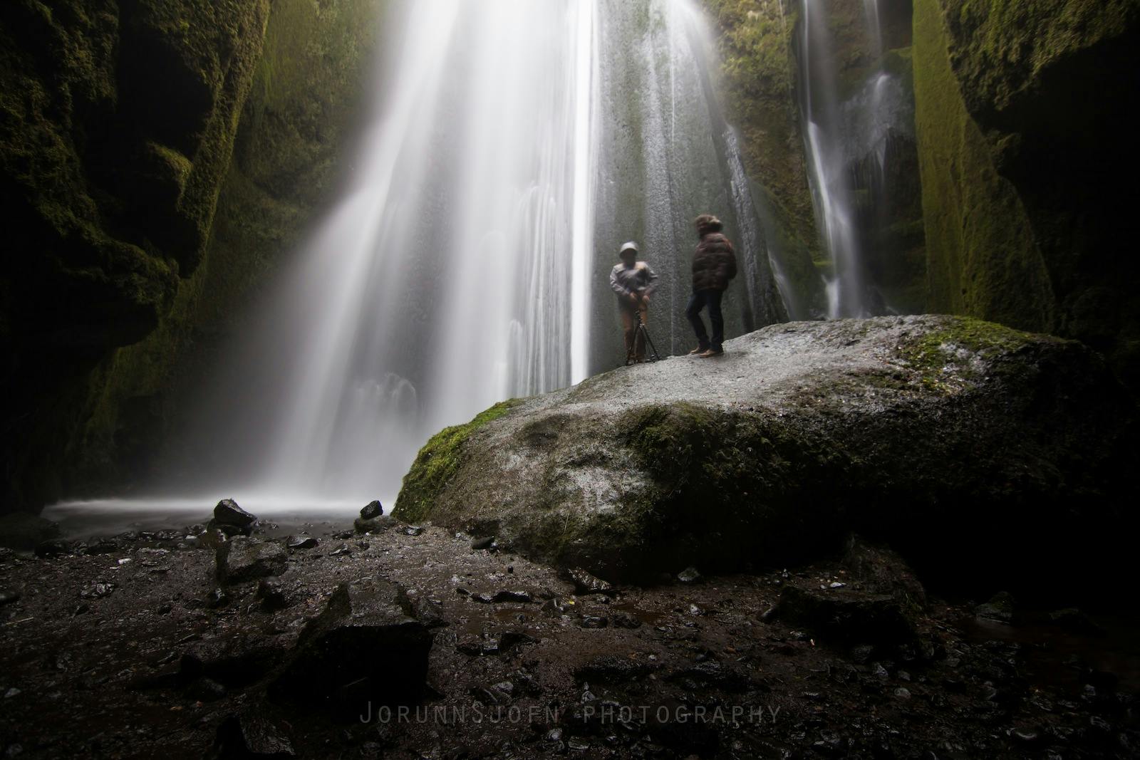
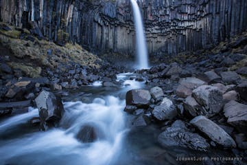
Chasing Waterfalls in Iceland
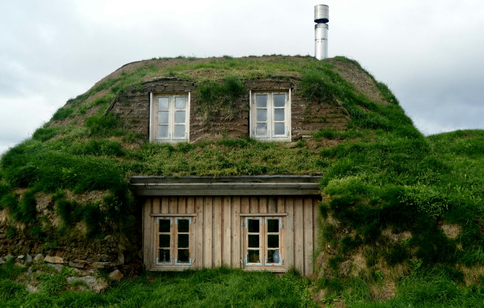
Iceland is spectacular in so many ways and Icelandic nature is quite unique with its vast landscape, volcanic activity, geothermal areas, glacier lagoons and sceneries, black sand beaches and spectLeer másSænautasel Turf House in the Highland of Iceland
In my search for turf houses around Iceland, I visited Sænautasel, which is a rebuilt turf house on Jökuldalsheiði heath in the highland of Iceland. It is, in my opinion, an extremely cute turf hoLeer másThe Dynamic Plant Lupine
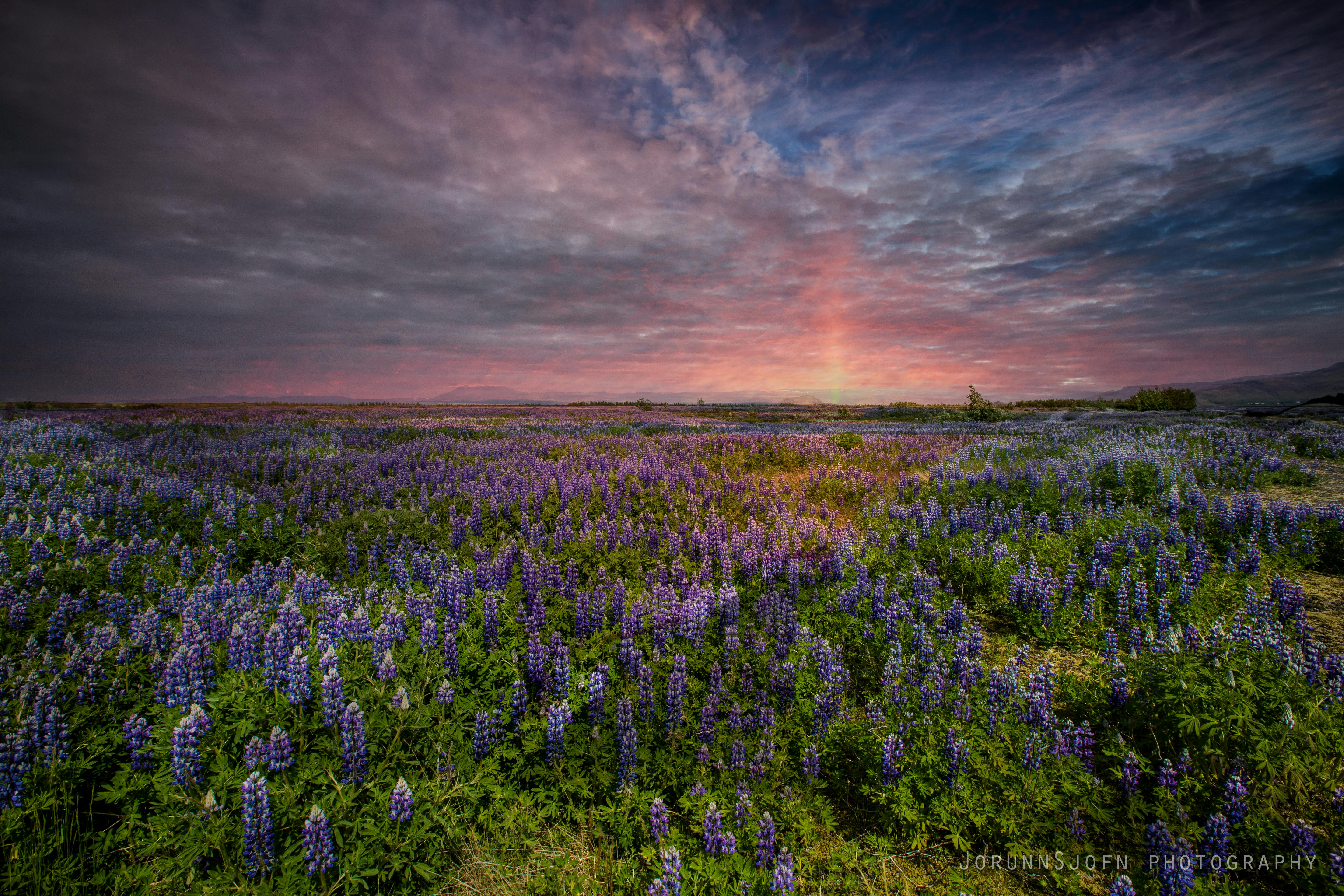
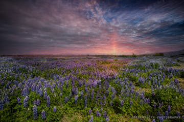
People have been asking me where to find lupines in Iceland. If you like them you should be able to find them easily in Iceland in summer. They are in bloom and visible almost wherever you drive aroLeer más


Descarga la mayor plataforma de viajes a Islandia en tu teléfono para gestionar todo tu viaje en un solo lugar
Escanea este código QR con la cámara de tu teléfono y haz clic en el enlace que aparece para añadir la mayor plataforma de viajes a Islandia a tu bolsillo. Añade tu número de teléfono o dirección de correo electrónico para recibir un SMS o correo electrónico con el enlace de descarga.


