Disponibilité limitée
Faites des économies en réservant tôt
Meilleur prix garanti
Sans frais de réservation ajouté
Cascades, plage de Reynisfjara - Excursion en français le mercredi
Rejoignez cette excursion vers la côte sud et découvrez notamment les cascades Seljalandsfoss et Skógafoss, le village de Vik et la plage de sable noir Reynisfjara.
Cette excursion est réalisée par un guide francophone le mercredi.
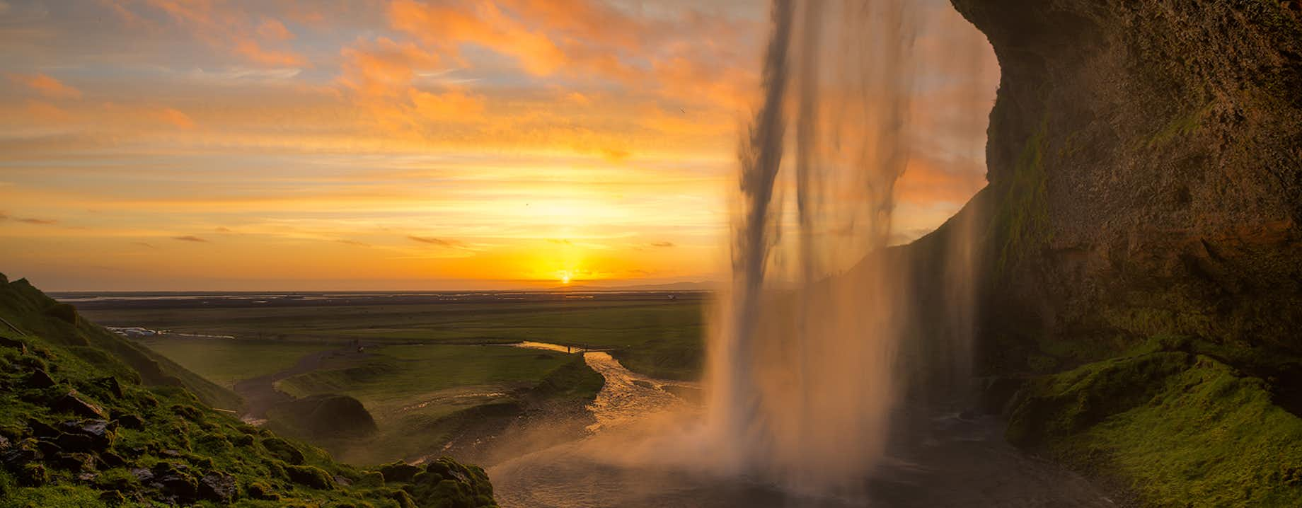
Après récupération à Reykjavik, vous mettez le cap vers la côte sud. Après une pause à Hvolsvollur, vous vous rendez au pied du glacier Solheimajokull et ses langues glaciaires. Par la suite, vous découvrez Vik, sa plage de sable volcanique de Reynisfjara et ses colonnes de basalte Garðar.
Le prochain arrêt est la cascade de Skógafoss avec ses 25 m de largeur (82 ft) et sa chute de 60 m de haut (197 ft). La cascade dégage de nombreuses petites gouttelettes d'eau et il suffit d'un peu de soleil pour voir la cascade avec un arc-en-ciel !
Vous continuez avec la découverte de Seljalandsfoss : l'une des plus grandes cascades d'Islande avec ses 63 m de haut (206 ft). La particularité de cette cascade est que vous pouvez faire le tour complet de celle-ci et notamment passer derrière Seljalandsfoss.
Sur le chemin du retour, vous passez par des routes de campagnes où vous pourrez apercevoir des moutons et chevaux islandais. Votre guide vous conte l'histoire de la région pour agrémenter votre voyage.
Ne manquez pas cette excursion à la découverte de la côte sud avec guide francophone le mercredi ! Cliquez sur "choisir une date" pour vérifier la disponibilité.
Bon à savoir
- Disponible : Tte l'année
- Durée : 10 heure(s)
- Activités : Visite naturelle
- Difficulté : Facile
- Langues : English
- Lieux phares : Skógafoss,
Skógafoss is one of Iceland’s biggest and most beautiful waterfalls with an astounding width of 25 meters (82 feet) and a drop of 60 meters (197 feet).
Due to the amount of spray the cascade produces, at least one rainbow is present any time the sun emerges from behind the clouds.
Located on the Skógá river, this mighty cascade is clearly visible from Route 1 and is an excellent place to stop and stretch the legs while travelling Iceland’s South Coast. The river below Skógafoss holds a large char and salmon population and is thus a favourite spot for fishermen in the summer.
The land underneath the waterfall is very flat, allowing visitors to walk right up to the wall of water. This will get you drenched, although, on a summer’s day, it can be quite tempting.
Skógafoss can also be viewed from the top as a steep staircase leads to an observational platform above the cascade. Many nesting seabirds can be found on the route up.
Geography
Skógafoss is located near the small village of Skógar, south of the Eyjafjallajökull glacier volcano. There you’ll find the Skógasafn folk museum, an open-air museum with both old wooden houses and turf houses, as well as a regional museum with various artefacts from this area.
A part of the Skógasafn Regional Museum is the Museum of Transportation, which showcases the history and evolution of transportation, communication and technologies in Iceland. There, you can see how this nation evolved from the age of the working horse to the digital communications of the 21st century.
The Skógasafn museum also includes a café and a museum shop, and in the village of Skógar, you will find both a hotel and a restaurant.
At the eastern side of Skógafoss, you will find one of Iceland’s most famed hiking routes; the Fimmvörðuháls pass. The 22 kilometre (14 miles) trail takes you along Skógá river, between two glaciers, Mýrdalsjökull and Eyjafjallajökull, before ending in the beautiful Þórsmörk valley.
Skógafoss is often visited alongside the waterfall Seljalandsfoss, which is just a little further along the South Coast. Both fall from cliffs of the same height, and while Skógafoss is much more powerful, Seljalandsfoss has a cave behind it, which means it can be fully encircled. It is also next to a much lesser known but still awe-inspiring waterfall, Gljúfrabúi.
Folklore
A gold ring is on display at the Skógasafn museum. According to legend, the ring is from a chest that was owned by Þrasi Þórólfsson, one of the first Viking settlers in the area, who by some accounts was a giant. Folklore states that before his death in 900 AD, Þrasi buried a chest filled with gold in a cave behind Skógafoss waterfall.
Many attempts were made to retrieve the chest after Þrasi’s death, and years later, locals managed to grasp a ring on the side of the chest. As they pulled, the ring broke off, and the treasure was lost forever. The ring was then given to the local church before it made its way to the museum.
Seljalandsfoss,Seljalandsfoss is a waterfall that can be fully encircled, situated on the South Coast of Iceland with a drop of 60 metres (200 feet).
Due to the waterfall’s close proximity to the Ring Road and impressive natural features, it is one the country's most famous and visited falls. Majestic and picturesque, it is one of the most photographed features in all of Iceland.
Geology and Surroundings
Seljalandsfoss waterfall, part of the river Seljalandsá, has its origins underneath the glacier Eyjafjallajökull. The volcano beneath this ice cap was the one that erupted in 2010 and caused havoc at airports across Europe.
The cascade of the falls is relatively narrow but falls from a tall cliff that once marked the country's coastline, the sea is now located across a stretch of lowlands and is visible from the site.
The most distinguishing feature of Seljalandsfoss is a pathway that stretches all the way around it. The cliffs behind the falls have a wide cavern, and rocks and paths allow guests to fully encircle it in summer.
Though a mesmerising opportunity, visitors should be prepared to get dampened due to the perpetual mist of the falls, which also tends to make the rocks of the pathway slippery.
Floodlights have been set up on both sides of the waterfall, which impressively illuminate the scene during the night when the midnight sun is not out. The lights were installed in 2001 due to the growing popularity of the falls as a tourist destination.
After visiting Seljalandsfoss, it is common for visitors to continue north to the waterfall Gljúfrabúi, which is found partially hidden behind a rock face. Because of Seljalandsfoss extreme popularity, Gljúfrabúi is widely considered the hidden gem of the scene, as it is too often overlooked.
Seljalandsfoss is also usually visited alongside the nearby Skógafoss. The waterfall falls from the same height, and while it cannot be encircled, it is much more powerful and steeped in the legend of a giant’s hidden treasure.
Visitor Centre Controversy
In 2017, it was announced that a visitor’s centre was to be constructed near the falls. The design of the building indicated that it would be seven metres (23 feet) high and 2,000 square metres (21,500 square feet) in size. Landowners in the area opposed to the idea, proclaiming that the centre would greatly alter the natural appearance of the waterfall’s renowned scenery.
The project has neither been fully approved nor wholly cancelled, with ideas surfacing of either significantly reducing the size of the construction, or moving the visitor centre’s location further away, for instance to the nearby farmstead Brekkuhorn.
Seljalandsfoss in Popular Culture
Along with a multitude of South Iceland’s most famous natural attractions, Seljalandsfoss can be seen in Justin Bieber’s music video for his song ‘I’ll Show You’. Please enjoy the video without emulating any antics that will endanger yourself or the environment.
The waterfall was also a featured waypoint during the first leg of the sixth season of The Amazing Race, an American reality TV series.
Vík í Mýrdal,Vík í Mýdral, or just Vík, is the southernmost village on the Icelandic mainland, located 186 kilometres (110 miles) from the capital Reykjavík.
Often visited by those travelling the popular sightseeing route along the South Coast, it is a wonderful place to stop, recharge, and if you are taking your time, rest for the night. Though it only has around 300 residents, the village is very popular amongst tourists for its convenience and beautiful surrounding landscapes.
Features near Vik
Reaching Vík from Reykjavík takes approximately two and a half hours, and en route, there are many marvellous features to admire. Two of the country’s most famous waterfalls, Skógafoss and Seljalandsfoss, lay between the two destinations; the former has awe-inspiring power, whereas the latter can be fully encircled.
The glaciers Eyjafjallajökull and Mýrdalsjökull can also be seen on clear days; both of these cover volcanoes which are particularly explosive, with Eyjafjallajökull famously disrupting European air travel in 2010. Out to sea in especially good weather, the Westman Islands can also be seen on the horizon.
Just before Vík are the popular birdwatching cliffs of Dyrhólaey, where you can also find an enormous rock arch curving out into the ocean. This is one of the best places for birdwatching in Iceland, with thousands of puffins nesting here from May to August.
The village itself sits opposite one of the country’s most famous features: Reynisfjara black sand beach. Considered one of the world’s most beautiful non-tropical beaches, it boasts incredible geology.
Particularly of note are the Reynisdrangar sea-stacks, said to be two trolls frozen in the light of the morning sun as they tried to pull a ship into shore.
Though this beach makes for a lovely walk, particularly for those staying in Vík overnight, as they can see it under the midnight sun or northern lights, it has its dangers. Sneaker waves can be notorious here, so visitors should stay far from the water’s edge, and never go for a swim. Lives have been lost here before.
The route to Vík from Reykjavík is beautiful and continues to be so as you travel further along the South Coast, through the Skeiðarásandur black-sand-plains into Vatnajökull National Park. This beautiful region is often the final destination of those passing through Vík, as it is home to the largest glacier in Europe, the Skaftafell Nature Reserve, and Jökulsárlón Glacier Lagoon.
Of course, ambitious travellers will carry on from here to encircle the full country.
Wildlife around Vik
Vík, due to its closeness to the Reynisfjall and Dyrhólaey cliffs, has a rich birdlife. Short walks from the village will take you to the nesting grounds of gulls, fulmar, guillemots, and in summer, puffins.
Due to its coastal location, visitors to Vík have a decent chance to see seals on the shore. There is also a slim chance to see whales or dolphins; the twenty or so species that live in Iceland’s waters can appear at any time.
Services in Vik
Vík has a wide variety of public services, due to its remoteness and its importance in connecting the east and west of Iceland. There are gas stations, shops and cafes, a swimming pool, a wool factory that can be visited, and a wide range of accommodation options for all budgets.
Please note, however, that as the village has such a small year-round population, those with special dietary requirements should purchase their food from Reykjavík before departing.
Reynisfjall,Reynisfjall is a tuff mountain on the South Coast of Iceland. It is five kilometres (three miles) long, 800 metres (2625 ft) wide and 340 metres (1115 ft) tall at its highest point.
Reynisfjall’s surroundings
The peak of Reynisfjall is best known for towering beside two of the most popular sites of the South, Reynisfjara and Reynisdrangar.
Reynisfjara is a black-sand-beach, once voted one of the world's most beautiful stretches of non-tropical coastline. It is famous for its ethereal, haunting appearance, although is also gaining notoriety for its dangerous sneaker waves.
Reynisdrangar, meanwhile, is composed of two basalt sea stacks that were once part of Reynisfjall. They are said to the petrified remains of two trolls, who were caught in the morning sun when trying to pull a ship to shore.
Many visitors come to these sites as they travel along the South Coast. The South Coast is one of the most popular sightseeing routes around Iceland, due to the wealth of diverse sites found along it.
Reynisdrangar,Reynisdrangar are impressive rock formations situated near the shore of Reynisfjara beach by the coastal village Vík on the South Coast of Iceland.
The formations are the remains of large and imposing sea cliffs, made up of basalt, that serve as a vital part of the area’s allure; they shoot dramatically out of the ocean under the looming cliffs of Mt. Reynisfjall, making for a beautiful site, and have a folklore that is equally impressive.
More modern visitors will be excited to know that these pillars also feature in Season 7 of Game of Thrones, at Eastwatch by the Sea.
Dangerous Waves
Before getting into the wonders of Reynisdrangar, it is important for potential visitors to be aware of the dangers at the site.
These majestic rock pillars rise from the sea just off of Reynisfjara, a famous black sand beach on the South Coast, by the village of Vík. Though incredible due to its diverse and dramatic geology, Reynisfjara is gaining a notorious reputation for its sneaker waves.
There are no significant landmasses between Antarctica and Reynisfjara, giving waves the entire length of the Atlantic Ocean to build strength. This means that even on still, summer days, they can rise from seemingly nowhere and chase far further up the sand than would ever be expected.
It is absolutely imperative, therefore, that guests stay at least 30 metres (98 feet) from the water’s edge. Those who flout these rules put their lives and the lives of others at risk; people have died here before.
Folklore
As with almost all bizarre features in this country, there is an Icelandic folk tale that explains the origin of the Reynisdrangar pillars and their eerie appearance.
According to legend, a couple of trolls saw a ship out to sea by night, and waded out to reach it. They got hold of it, and began to drag it to shore, but as so often happens in troll stories, they got their timing wrong.
Before they were even close to getting to the shade, dawn broke. The trolls and ship were instantly frozen into stone, and they have remained immortalised since, as a warning to their kin.
This is not the only folk tale in this area. According to local legend, two other trolls murdered a woman, whose husband hunted them down, tricked them into coming out at night, and ensured they too were turned to stone. Their remains can be found inland.
Surroundings & Wildlife
Most visitors will only see the Reynisfjara sea-stacks from the shore of Reynisfjara, although there is an incredibly rewarding alternative view of them from above. Those with a reasonable level of fitness can venture up the bewitching cliffs of Mt. Reynisfjall, by a road to the west of Vík.
The mountain furthermore holds thousands of puffins every summer, from May to August. These adorable creatures have very little fear of people, and can be approached within metres (although you should never try to touch them). Other birds can be seen gliding around the cliffs such as Arctic terns, fulmars and seagulls.
The oceans of Iceland are pregnant with life, so lucky visitors may also see seals in the water, or even one of Iceland’s twenty species of whale and dolphin.
Côte SudThe South Coast of Iceland is the country's most visited sightseeing route, along with the Golden Circle.
This incredible shoreline stretches from the greater Reykjavík area in the west to the magnificent Jökulsárlón glacier lagoon in the east and is lined with countless natural wonders such as cascading waterfalls, volcanoes, black sand beaches and glaciers.
Geography, Nature & Wildlife
The South Coast is the most easily accessible part of the country’s southern region, found along the Route 1 highway (the Ring Road), which encircles Iceland. The area consists of a diverse lowland that transitions between, marshlands, bays, cultivated pastures, estuaries and black sand deserts.
Underneath the soil rests a vast lava field, known as Þjórsárhraun. Its edges reach several hundred metres offshore where the ocean waves crash upon them, thereby protecting the lowland from the invasion of the sea. This results in the South Coast being unusually lacking in the deep fjords that so distinctly characterise the rest of Iceland's shoreline.
The region boasts vibrant bird life during all seasons. Freshwater birds nest in the marshlands and around the estuaries, while seabirds flock around the cliffs of Reynisdrangar and Dyrhólaey, including the North Atlantic puffin between May and August. Some species stay throughout the harsh Icelandic winter, including the northern diver, the loom and various species of gulls and ducks.
Seals are often found along the shore, particularly around the Jökulsárlón Glacier Lagoon and Diamond Beach. As with everywhere in Iceland, you should always keep an eye out to sea, as whales and dolphins reside all along its coastline.
Highlights of the South Coast
The South Coast offers an unprecedented array of natural wonders that draw thousands of visitors each day.
When driving the route from Reykjavík city, the first major features are the two great waterfalls of Seljalandsfoss and Skógafoss, which sit beneath the notorious subglacial volcano, Eyjafjallajökull. On clear days from these beautiful cascades, the Westman Islands can be seen across the ocean.
A little further down the route is the glacier Mýrdalsjökull, which covers one of Iceland’s most explosive volcanoes, Katla. Many glacier hikes are taken here upon the outlet of Sólheimajökull.
The aforementioned Dyrhólaey cliffs are next, home to many seabirds. Even if you come outside of puffin season, they are well worth a visit; jutting out to sea is an enormous rock arch of the same name, which you can marvel at from many angles.
Adjacent to the village of Vík is the famous black-sand beach, Reynisfjara, home to the rock pillars of Reynisdrangar, said to be two trolls frozen by the light of the sun. Though beautiful, this area is gaining notoriety for its dangerous sneaker waves, so visitors should be sure to stay well away from the edge of the water, even on a calm, still day.
There are no landmasses between Reynisfjara beach and the continent of Antarctica, so you can imagine how the waves can build momentum.
After passing through Vík, you will cross the glacial sand plain of Skeiðarársandur, before entering Vatnajökull National Park, home to the largest ice cap in Europe, Vatnajökull itself, dozens of glacial outlets and the magnificent Jökulsárlón glacier lagoon.
While almost all of these sites can be seen from Route 1, they make up a fraction of what the South Coast has to offer. The vast sand plains of Sólheimasandur are home to a crashed DC-3 Plane Wreck, and within the Vatnajökull National Park is the dramatic Skaftafell Nature Reserve.
Less than a kilometre from Seljalandsfoss is the hidden gem of Gljúfrabúi waterfall, and short distances from Jökulsárlón you will find the Diamond Beach, where icebergs wash on the black-sand shore, and another glacier lagoon, Fjallsárlón.
Heure du transfert : 08:30.
Merci d'être prêt à votre lieu de récupération à l'heure. Si votre lieu de récupération est à un arrêt de bus et que vous avez besoin d'assistance pour le trouver : n'hésitez pas à demander à la réception de votre hôtel ou directement à l'opérateur de l'excursion.
Transport durant l'excursion
Entrée au musée Skogar
Guide professionnel
Wifi à bord
Repas et boissons
A emporter avec vous :
Vêtements chauds et imperméables
Avis
Jordan De Meneghi
Nous avons passé une très bonne journée, le guide est très sympathique et Local pour le coup puisque c'est un islandais parlant Français. Nous recommandons cette journée avec ces magnifiques lieux visités et son super guide!
Filippo Scilipoti
Très bien. Passé un très bon moment et guide très gentille.