

Описание
Обзор
Описание
Отправьтесь в путешествие по Рейкьявику, Золотому кольцу и главным жемчужинам Южного побережья с этим 4-дневным зимним туром на автомобиле по Исландии! Тем, кто хочет свободы передвижения, возможности увидеть лучшие места страны зимой и поохотиться за северным сиянием, этот высоко оценённый тур подарит по-настоящему незабываемые впечатления.
Благодаря идеально продуманной программе вам не придётся тратить недели на самостоятельное планирование. Местные эксперты создали детальный, но гибкий маршрут, чтобы вы не пропустили ни одну из главных достопримечательностей и скрытых жемчужин Исландии. С отмеченными на карте локациями и инсайдерскими подсказками вы полностью готовы к невероятному путешествию.
Несмотря на подробный план, именно вы решаете, как долго задерживаться в каждом месте. Автомобиль даёт свободу — никаких строгих графиков и спешки за экскурсоводом. Исследуйте Исландию в своём ритме.
С момента прилёта и до вылета этот тур берёт организацию на себя. В стоимость входит аренда автомобиля и подобранное проживание на каждом этапе маршрута, с возможностью апгрейда для большего комфорта.
Ваше зимнее путешествие начинается после получения арендованного автомобиля в международном аэропорту Кеблавика или в Рейкьявике. Независимо от точки старта, вас ждёт новая, удобная машина с бесплатным Wi-Fi, идеально подходящая для зимних дорог Исландии.
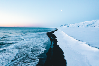
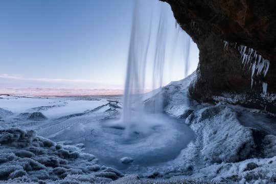
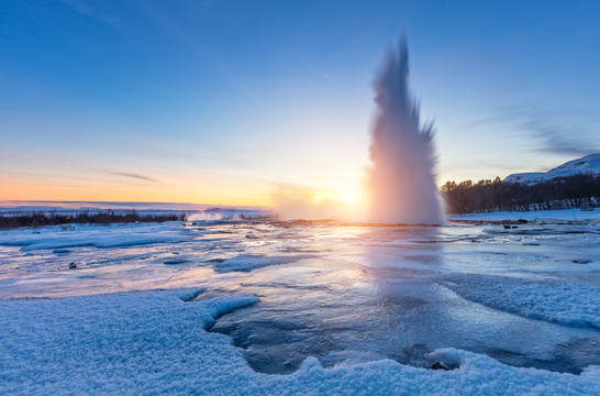
Во время поездки вы посетите Золотое кольцо и Южное побережье — регион гейзеров, ледяных водопадов и вулканических пляжей. Вас ждут такие культовые места, как геотермальная долина Гейсир, водопад Гюдльфосс, водопад Сельяландсфосс и пляж Рейнисфьяра с чёрным песком.
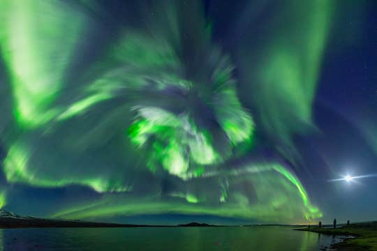
С наступлением темноты попробуйте поймать северное сияние — непредсказуемое, но завораживающее природное явление, освещающее небо Исландии с сентября по апрель. Маршрут тура подобран так, чтобы повысить ваши шансы увидеть это чудо.
В последний день вас ждёт знакомство с Рейкьявиком. Прогуляйтесь по Лёйгавегюру с его магазинами, барами, кафе и ресторанами. Не пропустите главные городские достопримечательности — церковь Хатльгримскиркья и концертный зал «Харпа».
Помимо осмотра достопримечательностей, вы можете добавить в маршрут яркие впечатления: верховую езду, ледниковый треккинг, снегоходы, посещение ледяной пещеры или релакс в Голубой лагуне. Эти экскурсии доступны по выгодным ценам и сделают ваше путешествие ещё насыщеннее.
После увлекательной поездки по самым популярным уголкам страны вы вернёте автомобиль в Рейкьявике или в аэропорту и отправитесь домой.
Комфорт гарантирован: ваш личный тревел-агент будет на связи 24/7. И, главное, если ваши планы вдруг изменятся, вы можете отменить бронирование за 24 часа до начала тура и получить полный возврат средств.
Наполните свой зимний отдых в Исландии яркими впечатлениями и захватывающими приключениями — бронируйте этот 4-дневный тур на автомобиле уже сегодня! Выберите дату и оформите поездку прямо сейчас.


