มีจำนวนจำกัด
สำรองล่วงหน้าเพื่อประหยัดเงิน
การันตีราคาที่ดีที่สุด
ไม่คิดค่าจอง
ทัวร์ลดราคาพิเศษจ่าย 1 ได้ถึง 2 | เที่ยวชมอุทยานแห่งชาติทุกแห่งและถ้ำน้ำแข็ง
เพลิดเพลินกับทัวร์ที่หลากหลายสำหรับช่วงฤดูหนาว ที่คุณจะได้ล่าแสงเหนือตามสถานที่ที่สวยที่สุดในประเทศไอซ์แลนด์ เช่น อุทยานแห่งชาติธิงเวลลีย์ (Þingvellir) วัทนาโจกุล (Vatnajökull) และสไนล์แฟลซเนส (Snæfellsnes) ไม่เพียงเท่านั้น คุณจะยังได้ปีนไปยังธารน้ำแข็งที่งดงามของประเทศและสำรวจภายในของอีกหนึ่งการเดินทางชมถ้ำน้ำแข็งที่น่าประทับใจ.
แพ็คเกจทัวร์ลดราคานี้เหมาะสำหรับนักท่องเที่ยวที่กำลังมองหาการที่จะได้ไปชมสถานที่ท่อเที่ยวไฮไลท์ของช่วงฤดูหนาวให้ได้มากที่สุดเท่าที่จะทำได้ และเหมาะสำหรับผู้ที่ต้องการที่จะมีส่วนร่วมในกิจกรรมที่น่าตื่นเต้นมากมาย เพลิดเพลินกับกิจกรรมทั้งหมดนี้โดยไม่ต้องวุ่นวายกับการขับรถหรือการจัดการแต่ละทัวร์.
คุณจะได้เข้าร่วมกับสองทัวร์ที่แยกกันในการท่องเที่ยว 5 วัน ดังนั้นมั่นใจได้เลยว่าคุณจะได้ใช้เวลาอันมีค่าของคุณได้มากที่สุดในประเทศ หลังจากการได้เที่ยวชมเส้นทางวงกลมทองคำที่มีชื่อเสียงที่สุดในโลกแล้ว คุณจะได้ออกไปสำรวจสถานที่ท่องเที่ยวที่น่ามหัศจรรย์มากมายตามเส้นทางชายฝั่งทางใต้ในช่วงเวลา 3 วัน.
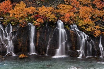
ในการเดินทางท่องเที่ยวครั้งนี้คุณจะได้เดินทางไปชมน้ำตกเซลยาแลนศ์ฟอสส์ (Seljalandsfoss) และน้ำตกสโกการ์ฟอสส์ (Skógafoss) ชายหาดทรายดำเรย์นิสฟยารา (Reynisfjara) และอัญมณียอดมงกุฏของประเทศไอซ์แลนด์ที่ชื่อว่า ทะเลสาบธารน้ำแข็งโจกุลซาลอน (Jökulsárlón) คุณจะได้ปีนธารน้ำแข็งโซลเฮมาร์โจกุล (Sólheimajökull) เพื่อที่จะได้ชมมุมมองแบบพาโนรามาที่น่าตื่นตาของพื้นที่บริเวณรอบๆ รวมทั้งยังได้เที่ยวชมถ้ำน้ำแข็งตามธรรมชาติภายในธารน้ำแข็งวัทนาโจกุล.
ในแพ็คเกจทัวร์ส่วนที่สองคุณจะได้ออกเดินทางโดยรถมินิบัสไปยังคาบมหาสมุทรสไนล์แฟลซเนสอันน่าทึ่ง ภูมิภาคที่มักถูกมองข้ามที่มีทั้งธารน้ำแข็งขนาดใหญ่และภูเขาไฟสไนล์เฟลส์โจกุล ระหว่างการเดินทางของคุณ คุณจะได้ชมน้ำตก ภูเขาไฟ ธารน้ำแข็งและน้ำพุร้อนพลังงานใต้พิภพจำนวนมาก รวมถึงแนวชายฝั่งที่งดงาม.
ความงดงามตามธรรมชาติของคาบสมุทรสไนล์แฟลซเนสที่ไม่มีใครแตะต้องและไม่มีมลพิษทางแสง นั่นหมายถึงท้องฟ้าช่วงกลางคืนที่ปลอดโปร่ง คุณสามารถมองเห็นการแสดงบนท้องฟ้าของแสงเหนือได้ คุณจะจบทัวร์ของคุณด้วยการเดินทางกลับไปยังเมืองเรคยาวิก (Reykjavík).
ใช้ช่วงเวลาในช่วงฤดูหนาวของคุณในประเทศไอซ์แลนด์ให้คุ้มค่าและประหยัดไปพร้อมๆกัน ตรวจสอบโปรแกรมด้วยการเลือกวันเดินทางของคุณ.
สิ่งสำคัญ
- ที่มีอยู่: กัน. - มีน.
- ระยะเวลา: 5 วัน
- กิจกรรม: ทัวร์ปีนธารน้ำแข็ง, ปีนถ้ำ, การเที่ยวชม, ล่าแสงเหนือ, กิจกรรมเกี่ยวกับวัฒนธรรม, ถ้ำคริสตัล
- ความยากลำบาก: ง่าย
- อายุต่ำสุด: 8 ปี.
- ภาษา: English
- ไฮไลท์ วงแหวนทองคำ,
The Golden Circle is a 300 kilometre (186 mile) route to the three most popular natural attractions in Iceland: the Geysir Geothermal Area, Gullfoss Waterfall and Þingvellir National Park.
This sightseeing trail is easy to do within half a day from Reykjavík, either by self-drive or on one of many tours. Some of these tours have additional activities, such as snorkelling or snowmobiling, or are conducted in a unique style, such as by helicopter, or under the midnight sun.
Within the three locations of the Golden Circle are some of the clearest examples of Iceland’s fascinating geological forces, magnificent landscapes, and rich culture.
The Geysir Geothermal Area
The Geysir Geothermal Area is a hot-spring haven in Haukadalur Valley. As could be guessed, it is home to a famous geyser, the name of which has named all others: Geysir itself.
Though this feature is currently in a phase of inactivity, its neighbour Strokkur more than makes up for it. Every five to ten minutes, it blasts a column of boiling water to heights that can reach over 40 metres (131 feet).
The surrounding area is dotted with fumaroles, hot springs, and mud-pits. There are also two other smaller geysers, Smiður and Litlí-Strokkur, that can be easily visited, as well as a hotel, restaurant, cafe and gift shop across the road.
Gullfoss Waterfall
The 'Golden Waterfall', Gullfoss one of the most beautiful and powerful waterfalls in Iceland, plummeting 32 metres (105 feet) in two tiers into the river gorge of the popular rafting river Hvítá. It is just a ten-minute drive from Geysir and is the furthest point on the Golden Circle from Reykjavík.
Gullfoss was very almost lost in the early 20th century when British developers sought to harness its incredible power for geothermal energy. Though they got the lease to the land, allowing them to go ahead with their plans, they met an unlikely adversary: the daughter of the farmer who owned it, Sigríður Tómasdóttir.
This resilient woman refused to see the waterfall, to which she and her sisters paved the first path, destroyed. She, therefore, walked over 200 kilometres (124 miles) to Reykjavík and back multiple times to meet with a lawyer in order to help change the decision.
Though the process was arduous and took years, eventually Sigríður managed to exhaust the resources of the businessmen and they withdrew their plans. Because of her, all Icelandic waterfalls are now protected from foreign investors, and she is considered one of Iceland’s first environmentalists and most important historical people.
Thingvellir National Park
The largest attraction of the Golden Circle is Þingvellir National Park. The Icelandic parliament was founded here in 930 and remained until the year 1798 before moving to Reykjavík, making it the original site of what is now the world’s longest ongoing parliament.
Today it is a UNESCO World Heritage Site and one of the most important places to visit in Iceland. This is not just for its historical and cultural values, but for also its magnificent landscape and dramatic geology.
Þingvellir is surrounded by a beautiful mountain and volcanic ranges, as it is located in a rift valley directly between the North American and Eurasian tectonic plates. This makes it one of the few places in the world where you can walk between the continents, in the Mid-Atlantic Rift.
The daring and qualified even have opportunities to snorkel or scuba dive in this no-mans-land, in a ravine filled with crystal-clear spring water called Silfra. The visibility here can exceed 100 metres (328 feet), revealing incredible geological sites. Though it never freezes over due to the constant flow of water into it, it is 2°C (35°C) throughout the year, thus underwater explorers are always equipped with protective suits.
Other sites of note are the magnificent Almannagjá gorge, which you can walk down into to reach the rift valley from the North American tectonic plate, and the beautiful lake Þingvallavatn, the largest lake in Iceland, which gleams to the south of the National Park.
Surrounding sites
Due to its convenient location in south-west Iceland, it is easy to visit the Golden Circle alongside with many other sites. Those seeking relaxation could head to the Secret Lagoon in Flúðir or Fontana Spa in Laugarvatn, those seeking adventure could book a trip to the ice tunnels of Langjökull glacier, and those seeking culture could visit the Sólheimar ecovillage. For more natural beauty, you can visit the nearby Kerið crater lake.
There are many tours that include such bonuses, but if driving yourself, you should check out this guide to great detours off the Golden Circle.
ไอว์แลนด์ ทาง ตะวันตก ,West Iceland is home to the country’s capital city, Reykjavík, and an array of impressive natural sites. These include Europe's most powerful hot spring, Iceland's most significant lava tube, fascinating glaciers, beautiful waterfalls important historical sites and more. It has three main districts outside of the capital area: Borgarfjörður, the Snӕfellsnes Peninsula, and Breiðafjörður.
Though also in the west, the Westfjords and Reykjanes Peninsula are considered to be in separate regions.
The Capital Area
Iceland’s capital city is Reykjavík, a settlement of 120,000 people (over 200,000 in the Greater Reykjavík Area) that was founded in 870 AD by Ingólfur Arnarson; this makes it the country’s oldest inhabited area.
It is a hot spot of culture, with festivals such as Sónar, Airwaves and Secret Solstice, events such as Pride and Culture Nights, and countless museums and galleries. The city is also renowned for its vibrant live music, cabaret and drag scenes, its street art, many sculptures, and its delicious cuisine.
Its architecture is particularly of note, with impressive buildings such as Hallgrímskirkja Church and the Harpa Concert Hall.
Reykjavík is where most visitors base themselves and the point from which most tour leaves. There is a comprehensive guide to Reykjavík on this site.
Borgarfjörður
Borgarfjörður is the fjord north of Reykjavík, within which is a wealth of beautiful historical and natural sites. Reykholt, for example, is a tiny village where medieval historian and poet Snorri Sturluson, author of Snorra-Edda and Heimskringla, once lived. Borgarnes, the main village of Borgarfjörður, is one of Iceland’s earliest towns, and home to the fascinating Settlement Centre.
In terms of nature, Borgarfjörður is home to the second highest waterfall in the country, Glymur. Other beautiful waterfalls include the magical and peaceful Hraunfossar and the raging rapids of Barnafoss which lie only a stone's throw apart. The area is also home to the longest lava cave in the country, Viðgelmir, the highest flowing hot spring in Europe, Deildartunghver, and just inland is Iceland’s second biggest glacier, Langjökull.
Snӕfellsnes
The Snӕfellsnes peninsula is a marvellous stretch of land in west Iceland. It is home to a unique mountain ridge with the majestic Snӕfellsjokull glacier and National Park at its westernmost point.
The region is often called Iceland in miniature due to its diverse sites, which include beautiful mountains such as Kirkjufell, geological wonders such as the Gerðuberg cliffs, and coastal formations such as Lóndrangar rock pinnacles.
Breiðafjörður
Breiðafjörður is the fjord that separates the Westfjords from the Snӕfellsnes Peninsula. It is a natural reserve with countless small islands and home to thousands of birds, including puffins.
The inner part of Breiðafjörður is the old farm site Eiriksstadir, the home of Eric the Red, the first European to land in Greenland, in the year 984 AD. His son was Leif Ericsson, the first European to land in America, in the year 1000.
เรคยาวิก,Reykjavík is the capital of Iceland and the northernmost capital of any sovereign state in the world.
Despite a small population (approximately 120,000, with just over 200,000 in the Greater Reykjavík area), it is a vibrant city that draws an ever increasing number of visitors every year. It is the financial, cultural and political centre of Iceland, and has a reputation of being one of the cleanest and safest cities in the world.
Geography
The city of Reykjavík is located in southwest Iceland by Faxaflói Bay. Throughout the ages, the landscape has been shaped by glaciers, earthquakes and volcanic eruptions and the area is geothermal; after all, its name translates to ‘Smoky Bay’.
Much of the current city area was subglacial during the Ice Age, with the glacier reaching as far as the Álftanes peninsula, while other areas lay under the sea. After the end of the Ice Age, the land rose as the glaciers drifted away, and it began to take on its present form.
The coastline of Reykjavík is set with peninsulas, coves, straits and islands, most notably the island of Viðey, and seabirds and whales frequent the shores. The mountain ring as seen from the shore is particularly beautiful.
Mount Esjan is the highest mountain in the vicinity of Reykjavík and the most distinctive feature of the coastline. This majestic summit is also highly popular amongst hikers and climbers. Other notable mountains that can be seen from the seaside are Akrafjall and Skarðsheiði.
On clear days, one may even see as far to the legendary Snæfellsjökull glacier, at the end of the Snæfellsnes peninsula.
The largest river to run through the city is Elliðaá in Elliðaárdalur valley, which is also one of Iceland’s best rivers for salmon fishing.
Transportation
There are no trains or trams in Iceland, but most people travel by car. The city also operates a bus system. There are two major harbours in town, the old harbour in the centre and Sundahöfn in the east.
The domestic Reykjavík Airport is located at Vatnsmýrin, not far from the city centre and close to the hill Öskjuhlíð and the restaurant, vantage point and exhibition centre Perlan. The international Keflavík Airport at Miðnesheiði heath then lies around 50 kilometres (31 miles) from the city.
Cars, jeeps and bicycles can be readily rented in the city and many organized tours are also being offered. It is, however, quite easy to walk between the major sites.
What to See & Do in Reykjavik
The local arts scene is strong in Iceland, with annual events and festivals, many of artists from which have hit the international stage.
Major events taking place in Reykjavík include Iceland Airwaves, Reykjavík Pride, RIFF (The Reykjavík International Film Festival), The Reykjavík Literature Festival, Culture Night, the Reykjavík Arts Festival, Food & Fun, the Reykjavík Fashion Festival and the Sónar music festival.
Amongst the famous people from Reykjavík are musicians like Björk Guðmundsdóttir and Sigur Rós, and writers Halldór Laxness (born on the main street, Laugavegur) and Arnaldur Indriðason.
Those eager to soak up the local culture should visit the city’s many museums, exhibitions and galleries, and check out live music at the cafés, bars, and concert venues dotted around. You could look at the programmes of what’s on at the Harpa music hall or the theatres, or else plan a few hours at the lighthouse at Grótta, the shopping street of Laugavegur, or the old harbour and the flea market.
You could even book a bird- and whale watching tour or a visit to Viðey island. There are a lot of things to do and the possibilities are endless.
Make sure to visit the public square of Austurvöllur, one of the city’s most popular gathering places, where you’ll also find the national parliament, the Alþingi, as well as the state church, a statue of independence hero Jón Sigurðsson, cafés, bars and restaurants.
Austurvöllur was central in the protests following the banking collapse of 2008, along with Lækjargata, home to the House of Government. You are also not likely to miss the great church of Hallgrímskirkja that towers over the city from the hill of Skólavörðuholt, from which you’ll get a great view of the city.
Try a walk by the city pond, Tjörnin, to greet the many birds that frequent the area and to visit the city hall, stationed by its banks. A beautiful park lies by the pond, ideal for a nice walk, and sometimes concerts get held there.
Further off is the campus of the University of Iceland, the Nordic house and the Vatnsmýrin wetland, a particularly pleasant place, but be mindful to not disturb the wildlife there by keeping to the pathways.
For a nice swim on a warm day, we particularly recommend Nauthólsvík beach, which is heated with geothermal water. Those who love a dip should also visit the Laugardalur valley, home to one of the city’s best swimming pools, which sits a short walk away from Ásmundarsafn gallery, a beautiful botanical garden and a domestic zoo.
A walk by the Ægissíða beach, with its old fishing sheds, in the west part of Reykjavík also holds a particular charm. From there, you can see all the way to president’s house at Bessastaðir, which is also a historical site in its own right, having been the educational centre of Iceland for centuries.
Another place that offers one of the city’s best views is Perlan, up on Öskjuhlíð hill. The hill itself is a popular place to spend a few hours, with over 176,000 trees and great opportunities for walking and cycling. Perlan also has and observation deck with great views, a café and an exhibition centre.
Furthermore, the city is a short drive from many of Iceland’s major attractions, most famously the Golden Circle and the Blue Lagoon. In close vicinity you’ll also find the Heiðmörk preservation area, a favourite local site of the people of Reykjavík, as well as the Blue Mountains, one of Iceland’s best skiing venues.
Finally, we’d like to stress that these are only some suggestions of the many things you might check out in Reykjavík. Whatever you choose to do, we hope you’ll be able to make the most of your visit and we wish you a pleasant stay in our capital.
โจกุลซาร์โลน,Jökulsárlón is Iceland’s most famous glacier lagoon. Conveniently located in the southeast by Route 1, about halfway between the Skaftafell Nature Reserve and Höfn, it is a popular stop for those travelling along the South Coast or around the Ring Road of the country.
Geography
As a glacier lagoon, Jökulsárlón is a lake that is filled with the meltwater from an outlet glacier. In this case, it is Breiðamerkurjökull, a tongue of Europe’s largest ice cap, Vatnajökull.
It stands out, however, due to the fact that it also fills with icebergs breaking from the glacier, some of which tower several stories high.
These icebergs, other than their scale, are notable for their colouration. Although they are, as expected, largely white, most are also dyed electric blue in part, with black streaks of ash from eruptions centuries past.
When the icebergs finally make it across the lagoon, they either drift out to sea or wash up on the nearby shore. Because of the way they glisten against the black sands of Breiðamerkursandur, this area has been nicknamed ‘the Diamond Beach’.
In spite of being a rather recent formation, Jökulsárlón is the deepest lake in the country, with depths of 248 metres (814 feet). With a surface area of 18 square kilometres (7 square miles), it is also growing to be one of the largest.
History
Jökulsárlón has not been around since Iceland’s settlement; it only formed around 1935. This was due to rapidly rising temperatures in the country from the turn of the twentieth century; since 1920, Breiðamerkurjökull has been shrinking at a dramatic rate, and the lagoon has begun to fill its space.
Today, the expansion of Jökulsárlón is accelerating. In 1975, it had less than half its current surface area.
In the relatively near future, it is expected that the lagoon will continue to grow until it becomes a large, deep fjord.
Though a dark omen for Iceland’s glaciers and ice caps in general, the retreat of Breiðamerkurjökull has resulted in an incredibly beautiful, if temporary, site. This has not been overlooked by Hollywood.
Jökulsárlón has been featured in the James Bond films A View to Kill in 1985 and Die Another Day in 2002, 2001’s Lara Croft: Tomb Raider, and 2005’s Batman Begins.
In 2017, Jökulsárlón was enveloped into the Vatnajökull National Park, thus it is now fully protected by Icelandic law.
Wildlife
Because of the wealth of herring and capelin that the tides bring into the lagoon, Jökulsárlón is somewhat of a hot-spot for Iceland’s wildlife.
In summer, it is a nesting site for Arctic Terns; stay well away from their nesting area, as these birds are notorious for the fierceness with which they protect their eggs, dive-bombing the heads of any they see as a threat. Skuas also nest on the lake’s shores in this season.
Seals can be reliably spotted here throughout the year, swimming amongst or else hauling out on the icebergs. Jökulsárlón provides them with a safe haven to rest and socialise, especially considering the waters of southeast Iceland are renowned for their population of orcas.
แม่น้ำ ฮวิทเอา,Hvíta is a glacier river in Arnessysla in South Iceland. It is one of the most popular rivers in Iceland for rafting, salmon fishing, and it is home to Iceland's most famous waterfall.
Gullfoss Waterfall
The river has its source in Hvítarvatn, by the roots of Langjökull. Many tributaries join it as it travels towards the ocean, making Gullfoss waterfall, which lays on its course, mightily powerful.
At 32 metres (105 feet) tall, it falls in two steps into a magnificent canyon. There are several viewing platforms around it, and a café and visitors centre a short distance away.
It can be seen in all seasons, with rainbows flying from its mists in summer and ice cladding the rocks around it in winter.
Rafting in Hvíta
Downstream from Gullfoss is the part of Hvíta that is most popular for kayaking, canoeing and rafting. These tours are open to all skill sets, even beginners.
These tours are not only exhilarating but expose guests to beautiful nature and geology.
วัทนาโจกุล,Vatnajökull glacier is the largest glacier in Europe, covering 8% of Iceland’s landmass.
It is the central feature of the Vatnajökull National park, found in the south west of Iceland, a popular spot for activities like glacier hiking from Skaftafell, boat tours in the Jökulsárlón glacier lagoon, and ice caving tours between November and March.
Facts about Vatnajokull
Vatnajökull has a surface area of approximately 8,100 square kilometres (3127 square miles); though it is rapidly shrinking due to climate change, its recession is not quite as advanced as at other glaciers, such as Langjökull and Mýrdalsjökull. In parts, it is a kilometre deep (over three thousand feet), and its average thickness is around half of that.
Vatnajökull also holds the tallest peak in Iceland beneath its ice; Hvannadalshnjúkur is 2,200 metres tall (7,218 feet). It also conceals some of the most active volcanoes in the country, the most notable being Grímsvötn, Öræfajökull and Bárðarbunga.
Volcanic activity in the region has occurred on and off throughout the centuries, and many geologists believe that several eruptions are overdue. If their calculations are correct, it would mean significant volcanic activity for Vatnajökull over the scope of the next half-century.
Depending on winds, this could result in worldwide consequences in terms of air-travel, agriculture and the general climate.
The glacier boasts over 30 outlet glaciers, which are channels of ice that flow out of ice caps but remain constrained on the sides of the valley. The major outlet glaciers of Vatnajökull include Dyngjujökull in the north, Breiðamerkurjökull, and Skeiðarárjökull to the south. To the west, one can find the outlet glaciers Síðujökull, Skaftárjökull and Tungnaárjökull.
Numerous rivers run out of Vatnajökull, making up some of the greatest glacial rivers in Iceland. The most notable are:
Tungnaá (west)
Köldukvísl (west)
Þjórsá (west)
Jökulsá á Fjöllum (north)
Skjálfandafljót (north)
Jökulsá á Brú (northeast)
Jökulsá í Fljótsdal (northeast)
Jökulsá í Lóni (south)
Hornafjarðarfljót (south)
Jökulsá á Breiðamerkursandi (south)
Skeiðará (south)
Núpsvötn (south)
Hverfisfljót (south)
Skaftá (south)
Vatnajokull National Park
Vatnajökull National Park was established in June 2008 and has slowly grown to include more and more areas. The park now covers an area of 14,141 square kilometres (5,460 square miles), 14% of the country. It is the second largest national park in Europe.
Rivers divide the highland plateau to the north of the park. The volcanic table mountain Herðubreið towers over this particular region, along with volcanoes Askja, Snæfell and Kverkfjöll.
The canyon Jökulsárgljúfur was carved out by glacial floods centuries ago. At the upper end of the canyon, you'll find Dettifoss, the most powerful waterfall in Europe. Further north, the horseshoe-shaped canyon Ásbyrgi is believed to have formed when Óðinn's eight-legged horse, Sleipnir, stepped his foot down from the heavens.
East around Snæfell, one can find wetlands and ranges, home to roaming herds of wild reindeer and abundant birdlife. Steep mountain ridges make up the south side of Vatnajökull, where outlet glaciers crawl onto the lowlands. The sandy plains of Skeiðarársandur also lie to the south, and the glacial river Skeiðará runs through this vast desert.
One of Iceland's most visited landmarks in the National Park is the Jökulsárlón glacier lagoon, which sits at the base of the outlet glacier Breiðamerkurjökull. Here, large icebergs that have broken off the glacier float across a vast lake before ending up in the Atlantic Ocean, or washed ashore on the nearby Diamond Beach.
This is one of the best seal-watching spots in the country.
The Future of Vatnajokull
The volume of Vatnajökull reached its peak around 1930 but has since been in a steady process of decline. Because of rising levels of global temperature, Vatnajökull has on average lost about a metre (three feet) of its thickness annually over the past 15 years.
If temperature levels continue to rise, the glacier could be all but gone nearing the end of the next century, leaving only small ice caps on top of the highest mountain summits.
Efforts are being made to prevent what some say is the inevitable, with reforestation projects going on all around the glacier, a proven method of cooling the area. Time will tell how successful they are.
Vatnajokull and Jokulsarlon in Popular Culture
The beauty of Vatnajökull National Park has not gone unnoticed by those in film or television. Many famous scenes have been shot here, starting with James Bond: A View to Kill in 1985. Other notable films with scenes here include Batman Begins, Lara Croft: Tomb Raider, and James Bond: Die Another Day.
Most famously, however, many places in Vatnajökull have been used in the HBO Series Game of Thrones, north of the Wall. The Wall itself is constructed with CGI using shots of the glacier.
สไนแฟลส์โจกุล,Snæfellsjökull is a glacier-capped volcano found on the tip of the Snæfellsnes Peninsula in west Iceland. It stands in a National Park of the same name, one of the only three National Parks in the country.
It stands at 1,446 metres (4,744 feet) tall, and on clear days, is visible across the bay from Reykjavík. The stratovolcano beneath Snæfellsjökull is 700,000-year-old.
The mountain is actually called 'Snæfell' (Snowy Mountain), though the 'jökull' (Glacier) is often added to help distinguish it from other mountains of the same name.
For the first time in recorded history, Snæfellsjökull had no snow or ice at its peak in August 2012, causing concern amongst locals that climate change is threatening the nature of the mountain.
History
Snæfellsjökull has several small villages surrounding it, including Hellissandur, Rif and Ólafsvík, all of which were some of the busiest commercial and fishing hubs in the country for much of the last millennium.
Fishing took off primarily in the 13th-Century, with fishing stations being built in all areas with easy access to the open ocean. The Snæfellsnes Peninsula was a notable centre of this industry, due to the fertile waters within Breiðafjörður bay.
One notable example would be the settlement of Dritvík; in spite of its minuscule size today, it once utilised around forty to sixty boats and employed up to six hundred people.
Fishing in the region declined during the 19th century due to change in Iceland’s industry and fish stocks, though it is still an important source of livelihood for those living on the Peninsula.
The Snæfellsjökull National Park was established in 2001, and tourism is rapidly changing the trade of the area.
In Folklore
Snæfellsjökull has, for centuries, been considered to be one of the world’s ancient power sites, a source of mysticism, energy and mystery for the peninsula’s superstitious population.
The feature takes a prominent role in Bárðar saga Snæfellsáss, a late 14th-century saga that tells the story of Bárður, half-human-half-troll, who became the 'guardian spirit of Snæfellsjökull'.
There are many rock formations on and around Snæfellsjökull that are said to be trolls petrified by sunlight, or else homes of the hidden people.
On November 5th, 1993, thousands of people came to Snæfellsjökull as some paranormal enthusiasts believed there would be an alien landing; CNN even showed up with a camera crew. Though the evening passed without a galactic invasion, the incident shows the strange significance of Snæfellsjökull to many.
In Literature
Snæfellsjökull serves as the entrance to a fantastical subterranean world in Jules Verne’s classic 1864 novel 'Journey to The Centre of The Earth.' Given its central place in the novel, Snæfellsjökull has become one of the most popular spots for visitors in Iceland and has inspired a wealth of writers, poets and artists.
Since 'Journey to The Centre of The Earth', Snæfellsjökull has appeared in the ‘Blind Birds’ trilogy by Czech science fiction writer Ludvík Souček (partially based on Jules’ work) and in ‘Under The Glacier’, a novel by Iceland’s only Nobel laureate, Halldór Laxness.
Nearby Attractions
Along with the glacier, attractions on the Snæfellsnes Peninsula include the two nearby basalt cliffs called Lóndrangar and the many fascinating lava formations at the beautiful Djúpalónssandur beach, such as the arch rock Gatklettur.
At Djúpalónssandur, one can also test their muscle as historic sailors once did with the four 'strength' stones, Amlóði ('Useless'), Hálfdrættingur ('Weakling'), Hálfsterkur ('Half Strength') and Fullsterkur ('Full Strength').
In the area, one can also explore the Saxhóll volcano crater and 'the singing cave' Sönghellir, which is named after the loud echoes inside.
สโคกาฟอสส์ ,Skógafoss is one of Iceland’s biggest and most beautiful waterfalls with an astounding width of 25 meters (82 feet) and a drop of 60 meters (197 feet).
Due to the amount of spray the cascade produces, at least one rainbow is present any time the sun emerges from behind the clouds.
Located on the Skógá river, this mighty cascade is clearly visible from Route 1 and is an excellent place to stop and stretch the legs while travelling Iceland’s South Coast. The river below Skógafoss holds a large char and salmon population and is thus a favourite spot for fishermen in the summer.
The land underneath the waterfall is very flat, allowing visitors to walk right up to the wall of water. This will get you drenched, although, on a summer’s day, it can be quite tempting.
Skógafoss can also be viewed from the top as a steep staircase leads to an observational platform above the cascade. Many nesting seabirds can be found on the route up.
Geography
Skógafoss is located near the small village of Skógar, south of the Eyjafjallajökull glacier volcano. There you’ll find the Skógasafn folk museum, an open-air museum with both old wooden houses and turf houses, as well as a regional museum with various artefacts from this area.
A part of the Skógasafn Regional Museum is the Museum of Transportation, which showcases the history and evolution of transportation, communication and technologies in Iceland. There, you can see how this nation evolved from the age of the working horse to the digital communications of the 21st century.
The Skógasafn museum also includes a café and a museum shop, and in the village of Skógar, you will find both a hotel and a restaurant.
At the eastern side of Skógafoss, you will find one of Iceland’s most famed hiking routes; the Fimmvörðuháls pass. The 22 kilometre (14 miles) trail takes you along Skógá river, between two glaciers, Mýrdalsjökull and Eyjafjallajökull, before ending in the beautiful Þórsmörk valley.
Skógafoss is often visited alongside the waterfall Seljalandsfoss, which is just a little further along the South Coast. Both fall from cliffs of the same height, and while Skógafoss is much more powerful, Seljalandsfoss has a cave behind it, which means it can be fully encircled. It is also next to a much lesser known but still awe-inspiring waterfall, Gljúfrabúi.
Folklore
A gold ring is on display at the Skógasafn museum. According to legend, the ring is from a chest that was owned by Þrasi Þórólfsson, one of the first Viking settlers in the area, who by some accounts was a giant. Folklore states that before his death in 900 AD, Þrasi buried a chest filled with gold in a cave behind Skógafoss waterfall.
Many attempts were made to retrieve the chest after Þrasi’s death, and years later, locals managed to grasp a ring on the side of the chest. As they pulled, the ring broke off, and the treasure was lost forever. The ring was then given to the local church before it made its way to the museum.
แซลลยาลานด์ฟอสส์ ,Seljalandsfoss is a waterfall that can be fully encircled, situated on the South Coast of Iceland with a drop of 60 metres (200 feet).
Due to the waterfall’s close proximity to the Ring Road and impressive natural features, it is one the country's most famous and visited falls. Majestic and picturesque, it is one of the most photographed features in all of Iceland.
Geology and Surroundings
Seljalandsfoss waterfall, part of the river Seljalandsá, has its origins underneath the glacier Eyjafjallajökull. The volcano beneath this ice cap was the one that erupted in 2010 and caused havoc at airports across Europe.
The cascade of the falls is relatively narrow but falls from a tall cliff that once marked the country's coastline, the sea is now located across a stretch of lowlands and is visible from the site.
The most distinguishing feature of Seljalandsfoss is a pathway that stretches all the way around it. The cliffs behind the falls have a wide cavern, and rocks and paths allow guests to fully encircle it in summer.
Though a mesmerising opportunity, visitors should be prepared to get dampened due to the perpetual mist of the falls, which also tends to make the rocks of the pathway slippery.
Floodlights have been set up on both sides of the waterfall, which impressively illuminate the scene during the night when the midnight sun is not out. The lights were installed in 2001 due to the growing popularity of the falls as a tourist destination.
After visiting Seljalandsfoss, it is common for visitors to continue north to the waterfall Gljúfrabúi, which is found partially hidden behind a rock face. Because of Seljalandsfoss extreme popularity, Gljúfrabúi is widely considered the hidden gem of the scene, as it is too often overlooked.
Seljalandsfoss is also usually visited alongside the nearby Skógafoss. The waterfall falls from the same height, and while it cannot be encircled, it is much more powerful and steeped in the legend of a giant’s hidden treasure.
Visitor Centre Controversy
In 2017, it was announced that a visitor’s centre was to be constructed near the falls. The design of the building indicated that it would be seven metres (23 feet) high and 2,000 square metres (21,500 square feet) in size. Landowners in the area opposed to the idea, proclaiming that the centre would greatly alter the natural appearance of the waterfall’s renowned scenery.
The project has neither been fully approved nor wholly cancelled, with ideas surfacing of either significantly reducing the size of the construction, or moving the visitor centre’s location further away, for instance to the nearby farmstead Brekkuhorn.
Seljalandsfoss in Popular Culture
Along with a multitude of South Iceland’s most famous natural attractions, Seljalandsfoss can be seen in Justin Bieber’s music video for his song ‘I’ll Show You’. Please enjoy the video without emulating any antics that will endanger yourself or the environment.
The waterfall was also a featured waypoint during the first leg of the sixth season of The Amazing Race, an American reality TV series.
ไกเซอร์ ,Geysir is a famous hot spring in the geothermal area of Haukadalur Valley, found in south-west Iceland.
Making up just one of the attractions along the world-renowned Golden Circle sightseeing route, alongside Þingvellir National Park and the mighty Gullfoss waterfall, Geysir is most well-known for having lent its name to geysers all around the world.
Geography
Though Geysir itself is rarely active these days, Haukadalur Valley boasts a plethora of hot springs and geysers, including the powerful Strokkur, Smiður and Litli-Strokkur.
Strokkur is, arguably, the country’s most famous hot spring, shooting vast jets of boiling water from 20 metres (65 feet) up to 40 metres (130 feet) high. Don’t worry about missing this incredible spectacle of nature, as Strokkur erupts every five to ten minutes; just make sure to have your camera ready.
Geysir is much larger, but years can go by between eruptions here; it is currently in an inactive phase. When it does erupt, the water can shoot up in the air as high as 70 metres (230 feet).
Just a few minutes walk north of Geysir are a wealth of fumaroles emanating steam and gas into the cool Icelandic air. Aside from watching the hypnotic pillars of steam, you will also be able to observe the yellow sulphuric stains along the fumaroles themselves, a result of the earth’s minerals crystallising around the rock bed.
At the southern part of the valley, Þykkuhverir, you’ll find various bubbling mud pots. These spooky brown cauldrons are actually fumaroles that boil up through the loose ground; after a dry spell, these mud pools are likely to transform into a hardened fumarole.
Nearby Attractions
About two kilometres (one mile) from Geysir is a preserved natural pool called Kúalaug. It has room for three to five people at a time, but care should be taken, as the area around the pool is very delicate. The temperature is 39-43°C (102-109°F), depending on where you are positioned in the pool.
The water is slightly muddy, as the pool is built on soil, and the bottom is slippery due to algae, so caution is advised when relaxing here.
Haukadalur has also seen a rise in reforestation in recent times thanks to continued experiments and research in the area. Today, Haukadalsskógur is one of the largest forests in south Iceland, boasting accessible walking paths (also for wheelchair users), fascinating vegetation and The Tree Museum, built in the memory of forester Gunnar Freysteinsson.
History
Haukadalur has been inhabited and used as a church site since the Age of Settlement. Given its historic value, it should be noted that scholar, Ari “The Wise“ Þorgilsson, grew up here; it was also where the first pastoral school in Iceland was built.
The current wooden church was last rebuilt in 1938 but its architectural style dates back to 1842, making it well worth a visit to see how Iceland looked before industrialisation.
For accommodation, Hotel Gullfoss is approximately 7 kilometre from the Geysir area, and closer still is Hotel Geysir on the other side of the road from the attraction, where you will also find a restaurant, café and a souvenir shop.
กุลล์ฟอสส์,Gullfoss (translated to ‘Golden Falls’) is one of Iceland’s most iconic and beloved waterfalls, found in the Hvítá river canyon in south-west Iceland.
The water in Hvítá river travels from the glacier Langjökull, before cascading 32 meters (105 feet) down Gullfoss’ two stages in a dramatic display of nature’s raw power. This incredible site is seen by most visitors, as it is on the Golden Circle sightseeing route.
Because of the waterfall’s two stages, Gullfoss should actually be thought of as two separate features. The first, shorter cascade is 11 metres (36 feet), whilst the second drop is 21 metres (69 feet). The canyon walls on both sides of the waterfall reach heights of up to 70 metres (230 feet), descending into the great Gullfossgjúfur canyon. Geologists believe that this canyon was formed by glacial outbursts at the beginning of the last age.
In the summer, approximately 140 cubic metres (459 cubic feet) of water surges down the waterfall every second, whilst in winter that number drops to around 109 cubic metres (358 cubic feet). With such energy, visitors should not be surprised to find themselves drenched by the waterfall’s mighty spray.
As mentioned, Gullfoss makes up a part of the highly popular Golden Circle sightseeing route, alongside Geysir geothermal area and Þingvellir National Park. Many Golden Circle tours include additional activities that can be taken from Gullfoss, such as ascending the mighty nearby glacier Langjökull and entering its ice tunnels, or snowmobiling along its gleaming surface.
History
In the early days of the last century, Gullfoss was at the centre of much controversy regarding foreign investors and their desire to profit off Iceland’s nature. In the year 1907, an English businessman, Howell, sought to utilise the waterfall’s energy and harboured ambitions to use its energy to fuel a hydroelectric plant.
At the time, Gullfoss was owned by a farmer named Tómas Tómasson. Tómas declined Howell’s offer to purchase the land, stating famously “I will not sell my friend!” He would, however, go on to lease Howell the land without the knowledge of a loophole that would allow him to proceed with his plans.
It was Tómas’ daughter, Sigríður Tómasdóttir, who would lead the charge to stop Howell’s ambitions. Having grown up on her father’s sheep farm where she helped pave the first road to Gullfoss, she sought to get the contract nullified, hurriedly saving her own money to hire a lawyer.
The ensuing legal battle was an uphill struggle; the case continued for years, forcing Sigríður to travel many times by foot to Reykjavík, a distance of over 100 kilometres (62 miles). Circumstances became so difficult that Sigríður threatened to throw herself into the waterfall if any construction began.
Her tenacity, however, resulted in success. In 1929, Howell’s withdrew from the lease, unable to keep up with the costs and difficulties of his plan. The waterfall fell back into the hands of the Icelandic people.
Today, Sigríður is recognised for her perseverance in protecting Gullfoss and is often hailed as Iceland’s first environmentalist. As such, she is one of the most famous figures in Iceland’s history. Her contribution is forever marked in stone; a plaque detailing her plight sits at the top of Gullfoss.
Interestingly, the lawyer who assisted Sigríður, Sveinn Björnsson, went on to go down in history too; he became the first president of Iceland in 1944.
Restaurant / Cafe
Besides Gullfoss, visitors can enjoy the views from Gullfoss Cafe, a locally run delicatessen that serves a wide variety of refreshments and meals. The menu has options to tantalise everyone’s taste buds: hot soups, sandwiches, salads and cakes. There is also a shop on site where visitors’ can browse and purchase traditional Icelandic souvenirs.
เอยาฟยาลลาโจกุล ,The glacier volcano of Eyjafjallajökull is notorious the world over for causing havoc to air travel in 2010, and stumping television anchors everywhere as they tried to pronounce it. 1651 metres (5427 feet) tall, it is one of the most dominant features of the South Coast.
Geography
The glacier of Eyjafjallajökull is approximately 100 square kilometres (39 square miles), making it the country’s sixth largest. It sits close to the fourth greatest, Mýrdalsjökull, which also conceals another notorious volcano, this one called Katla.
While Eyjafjallajökull’s eruption was huge and disruptive, it pales in comparison to the potential of Katla. Far more explosive, and under much thicker ice, an eruption here in unfavourable wind conditions could have worldwide consequences.
The magma chambers between both of these mighty volcanoes are connected, and, unfortunately for us, an eruption at Eyjafjallajökull is usually followed by one at Katla within a decade.
Eyjafjallajökull has many glacial outlets, the most famous being Gígjökull. Many rivers flow from its meltwater, and one of these falls into the beautiful South Coast waterfall, Seljalandsfoss, which it is possible to fully encircle.
Eruptions
Eyjafjallajökull’s most recent eruption was no doubt the most famous in Iceland’s history (although the honour really should go to Laki, the 1783-4 eruption of which caused an ash cloud so great that Europe fell into a famine that many historians believe led to the French Revolution). On March 27th, 2010, magma began to bubble from beneath the surface, and by April 14th, ash was starting to billow from the peak.
800 people were evacuated, in fears not of magma, but of equally dangerous glacial floods, which have decimated Icelandic towns in the past. Animals were ordered to be kept inside, and those with respiratory problems told they should also stay indoors.
Air travel across Europe was halted, as, by the evening of April 15th, the ash was already over the UK, Scandinavia, and parts of Germany. Holidaymakers were trapped, waiting for news, and would end up stuck for eight days; in Scotland and Ireland, there were even flights delayed in May due to lingering effects.
Thankfully, no one was injured, although the ash is thought to have caused respiratory issues for some in the south of the country. Many farms were also destroyed by the ash and floods, with some farmers still struggling to recover today.
Since settlement in 874, Eyjafjallajökull has also erupted in 900, 1612, and from 1821 to 1823. The latter released a huge amount of fluoride which is believed to have affected the bone health of humans and animals alike at the time.
Eyjafjallajokull today
Eyjafjallajökull is now entirely safe to visit and is seen on most tours of the South Coast in clear weather. In the town of Hvolsvöllur, there is a visitor’s centre on the volcano, which focuses on the experience of one family whose farm, Þorvaldseyri, was one of the many destroyed by the floods, lava and ash.
It is very unlikely that Eyjafjallajökull will erupt again any time soon, with hundreds of years between each eruption, but as mentioned, its neighbour Katla might start rumbling...
ธิงเวลลิร์,Þingvellir National Park is the only UNESCO World Heritage site on the Icelandic mainland and one of the three stops on the world famous Golden Circle sightseeing route, alongside the Haukadalur Geothermal Valley (Geysir) and Gullfoss Waterfall. Just to the south of the park is Þingvallavatn, Iceland’s largest natural lake.
Geography
The first thing that visitors to the National Park notice is its sheer aesthetic beauty; dried magma fields, covered in Icelandic moss, sit carved by glacial springs and surrounded by a bowl of ancient mountain peaks.
Two of the greatest attractions in the park are the exposed North American and Eurasian tectonic plates; it is one of the only regions in the world where you can see geology such as this on land.
Visitors are encouraged to walk along the North American tectonic plate, where they can read more about the area’s fascinating formation and history, before descending into the valley below.
History
Þingvellir can be anglicised to ‘Fields of Parliament’, a nod to the area’s fascinating history and relevance to Icelandic culture. It is here, after all, that the world’s first democratically elected parliament that remains functioning, Alþingi, was formed in 930 AD.
It may seem unlikely that Vikings would want to be under such an uncombative government, but the thirty or so clans that lived in Iceland at the time sought to prosper in their harsh new environment.
The first gathering was such a success that the meetings became annual, and it became a place where disputes were settled, criminals were tried, and laws to the benefit of all were laid down.
This saw the birth of the Icelandic Commonwealth, a time of independence and freedom for the Icelandic people before they became constituents of the Norwegian monarchy. Sessions would continue to be held at Þingvellir until 1798.
Though the parliament was removed by the Danish at this time, it returned 1845 to Reykjavík.
Another major reason as to why Þingvellir is considered so important to Icelanders is the fact that this is where the decision was made to abandon the belief of Paganism and the Norse Gods; the people adopted Christianity in 1000 AD under threat of invasion from Norway.
This turning point in history was left to the pagan lawspeaker, Þorgeir Þorkelsson, who rested on the choice for one day and one night before reappearing to share his decision.
To symbolise the country’s change, he threw idols of his old deities into the northern waterfall Goðafoss, the name of which translates to ‘Waterfall of the Gods’.
Silfra Fissure
Þingvellir is one of the most widely visited attractions in Iceland, in large part due to the fact that it is home to the glacial spring, Silfra fissure, one of the top ten sites in the world for snorkellers and scuba divers.
Silfra (meaning ‘Silver’) is a submerged ravine within the park, boasting visibility of up to 100 metres (328 feet) and a temperature just above freezing. Participants in these tours will be attired at the Silfra carpark in neoprene hoodies and gloves, as well as an undersuit and drysuit for thermal protection.
เดลตาร์ทุงกาแควร์ ,Deildartunguhver is a hot spring located in Reykholtsdalur, a district of west Iceland. Deildartunguhver is the highest flowing hot spring in Europe and is widely known for its rapid flow rate of 180 litres (380 pints) per second.
Geothermal activity at Deildartunguhver
Reykholtsdalur is one of Iceland’s most popular places to see hot springs, along with the Geysir Geothermal Area, the Highlands, the Reykjanes Peninsula, Reykjadalur Valley and Námaskarð Pass. While each of these areas have their appeal, at no other does the water rise with such ferocity.
The water at Deildartunguhver hot spring emerges at a constant 97 degrees Celsius (207 degrees Fahrenheit), making it incredibly dangerous for those who venture too close. Thankfully, there are a number of wooden walkways and observation points that lead you around the hot springs without putting you at any risk.
Due to the sheer energy bubbling under Deildartunguhver, much of the water is used for heating Icelandic homes. One pipe travels 34 kilometres (21 miles) to Borgarnes, whilst another travels 64 kilometres (40 miles) to Akranes.
This means that if you’ve taken a shower or bath within a 64-kilometre radius of Deildartunguhver, you will have touched the water from the hot spring.
All Icelandic hot water comes from hot springs such as this, except in some parts of the Westfjords which are now geologically much older than the rest of the country, and thus less active.
This is a fantastic example of how Icelanders efficiently use the geothermal energy provided and is one of the major reasons as to why Iceland has such an excellent reputation for green energy.
Points of Interest at Deildartunguhver
Whilst in the area, many visitors choose to make a stop at Krauma Geothermal Bath & Spa, a fantastic and relaxing complex that makes for a cheaper, more isolated alternative to the Blue Lagoon.
Visitors to Kraua will experience the hot water of Deildartunguhver blended perfectly with glacial water from Iceland’s smallest ice cap, Ok (which rhymes with ‘talk’), creating the perfect bathing temperature.
Krauma has a total of six pools, a relaxation room and two steam baths.
Visitors to Deildartunguhver with an interest in botany will also be able to check out the Blechnum Spicant, aka; “deer fern”, a type of plant that grows nowhere else in Iceland.
Surroundings of Deildartunguhver
Deildartunguhver is located in west Iceland. The two most notable points of interest nearby are two waterfalls, Hraunfossar and Barnafoss.
Hraunfossar, or the ‘Lava Falls’, is, in fact, a series of tiny cascades that trickle through an old lava field. Barnafoss, or ‘the Children’s Falls’, is a more powerful rapid, steeped in a dark legend.
Deildartunghver is also near Víðgelmir, the longest lava cave in the country, trailing for 1,595 metres (5,200 feet) beneath the surface of the earth.
The most significant settlement near Deildartunghver is Reykholt, a beautiful village with a fascinating history. This settlement was once home to Snorri Sturluson, a historian, writer, chieftain and poet without whom we would know very little of the Nordic mythology, folklore and history at the time.
His works, and life--full of politics, betrayal, affairs and war--can be learnt about in the town at the Snorrastofa Centre.
สทรอคคูร์ ,Strokkur is Iceland’s most visited active geyser. One of the three major attractions on the world-famous Golden Circle sightseeing route, it is usually visited alongside Gullfoss Waterfall and Þingvellir National Park.
Strokkur is found in the Geysir Geothermal Area, titled after the Great Geysir, which lent its name to all others across the world. It is the greatest active geyser on site; Geysir itself is in a period of inactivity. Strokkur erupts more regularly than Geysir ever did, blasting water to heights of around fifteen to twenty metres every five to ten minutes, although it is known to reach up to forty metres.
Strokkur and Haukadalur Valley
Strokkur is the primary feature of the Haukadalur valley and the main reason why it is one of the most visited sites in the country. While Geysir will very occasionally still erupt to enormous heights, it is nowhere near reliable enough to justify the area’s popularity.
Haukadalur valley, however, has many other features that make it worth a visit. The natural beauty of the area is shaped by the forces of the earth; fumaroles, hot-springs, mud-pits and other little geysers are littered around, and the ground itself is dyed vividly by elements such as sulfur (yellow), copper (green) and iron (red).
Opposite the main geothermal area in Haukadalur Valley is a restaurant, cafe, hotel and luxury gift shop.
Science behind Strokkur
Active geysers like Strokkur are rare around the world, due to the fact that many conditions must be met for them to form. They are thus only found in certain parts of highly geothermal areas.
The first condition that is necessary is an intense heat source; magma must be close enough to the surface of the earth for the rocks to be hot enough to boil water. Considering that Iceland is located on top of the rift valley between the North American and Eurasian tectonic plates, this condition is met throughout most of the county.
Secondly, you will need a source of flowing underground water. In the case of Strokkur, this comes from the second largest glacier in the country, Langjökull. Meltwater from the glacier sinks into the surrounding porous lava rock, and travels underground in all directions.
Evidence of this flowing water can be found in Þingvellir National Park, where there are many freshwater springs flowing straight from the earth.
Finally, you need a complex plumbing system that allows a geyser to erupt, rather than just steam from the ground like a fumarole. Above the intense heat source, there must be space for the flowing water to gather like a reservoir. From this basin, there must be a vent to the surface. This vent must be lined with silica so that the boiling, rising water cannot escape before the eruption.
Environmental Issues with Strokkur
One of the main reasons that Geysir entered a period of inactivity was due to the fact soap used to be pumped into the vents to make the eruptions more dramatic; it damaged the structure of the vent and prevented water building up. Strokkur, therefore, is guarded against all interference, with chains keeping visitors a good distance away.
Unfortunately, however, there have been incidents where people have meddled with its natural state. For example, an artist called Marco Evaristti once poured food colouring into it to make the eruption pink. He defended himself by claiming that nature was open to artists to utiltise and the fact the colouring was all-natural, but he became a pariah amongst many Icelanders, and was arrested and fined (though never paid it).
สไนล์แฟลซเนส,Snæfellsnes is a large peninsula extending from West Iceland, often nicknamed ‘Iceland in Miniature’ due to the wealth and diversity of natural features found there.
Home to the Snæfellsjökull National Park, at the centre of which is a subglacial volcano that towers over the scenery, this peninsula is home to waterfalls, rock formations, beautiful beaches, historic villages, and intricate folklore.
In particularly clear weather, the Snæfellsnes Peninsula can sometimes be seen from Reykjavík, making views across the water from the capital of Iceland particularly beautiful. Those with an extended stay in Iceland are recommended to look into spending at least a day here.
Natural Sites of Snaefellsnes
The peninsula stretches 90 kilometres (56 miles) from West Iceland, between the Reykjanes Peninsula to the south and Westfjords to the north. A mountain range runs along with it, consisting of both active and dormant volcanoes, culminating at the magnificent, ice-capped Snæfellsjökull volcano.
Starting along the south side of the Snæfellsnes Peninsula, you will first come to the Eldborg crater, which can be scaled for some incredible views, and the Gerðuberg basalt cliffs, where hundreds of hexagonal basalt columns are arranged with geometric precision. You will then start hugging the coast, where animal-lovers can find the Ytri-Tunga beach and its year-round seal colony.
The next site of particular natural beauty is the Rauðfeldsgjá Gorge, a cleft in a huge cliff face that it is possible to climb into. A stream runs through here, so those who want to plumb its depths will get wet. Those with decent clothing, sturdy shoes and reasonable fitness, however, will be able to get quite far.
After Rauðfeldsgjá, you will come to the mighty basalt plugs of Lóndrangar. All that remains of what was once a massive crater, these two enormous pillars are not only awe-inspiring in their scale, but home to thousands of nesting seabirds.
You will then enter Snæfellsjökull National Park, which, in spite of being the smallest of the country’s three national parks, is pregnant with destinations worth visiting.
The most historic of these is Djúpalónssandur beach. Comprised of black, volcanic sands, it is best known for the four lifting stones that remain on the beach from a bygone age. Fishermen would use these stones to mark their strength and gage their suitability to working on the dangerous waves.
Within the National Park are also two lava caves that can be entered in summer. Sönghellir is renowned for the musical qualities of its echoes, whereas Vatnshellir is favoured for its easy access and vivid colouration. There is a small entry fee to the latter, and you cannot enter it without a guide.
Of course, however, the highlight of this part of the Peninsula is no doubt Snæfellsjökull itself. Even if you are not ascending it on a glacier hiking tour, it is worth stopping by to marvel at.
This is particularly the case for literature enthusiasts. The adventure in the Jules Verne novel ‘A Journey to the Centre of the Earth’ begins here, and it is the backdrop to the lesser-known novel ‘Under the Glacier’, by Nobel-Prize winning Icelander, Halldór Laxness.
On the north side of the peninsula is the haunting Berserkjahraun lava field, near the town of Bjarnarhöfn, the history of which weaves deception and murder. Most notable on this stretch, however, is the mountain Kirkjufell, often described as the most photographed mountain in Iceland, and known as "the mountain shaped like an arrowhead" from the popular HBO series, Game of Thrones.
Cultural Sites of Snaefellsnes
There are a few small and beautiful villages dotted across the peninsula, the majority of which are on the northern side, where the fishing is better. Most notable are Arnarstapi, Hellnar, Búðir, Hellissandur, Ólafsvík, Grundarfjörður and Stykkishólmur.
The last of these is highly popular for travellers, featuring a volcano museum and a ferry that takes you across the fascinating Breiðafjörður bay to the south border of the Westfjords with a stop at the remote island of Flatey.
Other museums of note are the Maritime Museum at Hellissandur, the regional museum at Ólafsvík, and, last but not least, the shark museum at Bjarnarhöfn, where you can taste the Icelandic ‘delicacy’, hákarl, or fermented shark.
ควาลฟยอร์ดูร์ ,Hvalfjörður is a fjord in southwest Iceland. The fjord is approximately 30 kilometres (19 miles) long and five (three miles) kilometres wide.
Nature and Landscape
The landscape of Hvalfjörður is varied and beautiful, with wide areas of flat land along majestic mountains, green vegetation in summer and beaches cut with creeks.
The area is rich in bird life and is home to seals, but despite its name, which translates to ‘Whale Fjord,’ it is not known for its whale or dolphin populations. Two theories exist on how it got its name; either that it was once home to whales before fish stocks moved away, or because of the general shape of the bay.
The area has recently been part of Iceland’s successful reforestation effort.
Natural attractions in the area are plentiful but most significant is Iceland's highest waterfall, Glymur, in the river Botnsá. There are also plenty of interesting hiking trails in the area, such as Síldarmannagotur, leading north, and Leggjabrjótur, leading east towards the area of Þingvellir National Park.
History and Culture
Historically, Hvalfjörður was home to one of the main whaling stations in Iceland, with ships heading out into Faxaflói Bay. It was one of the most important naval stations in the North Atlantic during World War Two, when Iceland was occupied by the Allies after the Nazis conquered Denmark.
The old whaling station and a war museum can be found in the fjord.
Iceland's main psalm poet, Hallgrímur Pétursson, writer of the ‘Passia Hymns,' lived in Hvalfjörður. The area was also the home of the late Sveinbjörn Beinteinsson, poet and performer and head of the Icelandic Pagan Association.
Economy
Most inhabitants of the fjord live in rural areas, and there is some farming in the area. Until the 1990s those travelling between Borgarnes and Reykjavík had to take a long detour around the fjord, but this was solved with a tunnel that travels beneath it, finished in 1998.
Grundartangi promontory in Hvalfjörður has one of the largest harbours in the country and two industrial plants. One is a ferrosilicon plant, operated since 1979, the other an aluminium smelter, operated since 1998.
Both of these were controversial during their construction, and continue to be controversial during their ongoing operation. Along with whaling and hydroelectric dams, smelters and silicone plants are the hottest environmental debates going on in Iceland.
โซลเฮมาโจกุล,Sólheimajökull is an outlet glacier of the mighty icecap of Mýrdalsjökull on the South Coast of Iceland. It is one of the most easily accessible glaciers to reach from Reykjavík, just 158 kilometres (98 miles) away.
For those who are based in Reykjavík, it is by far the favourite spot on which to take guided glacier walks, competing nationally for popularity only with Svínafellsjökull in the south-east.
Geography of Solheimajokull
About eight kilometres long and two kilometres wide (five miles long and just over a mile wide), Sólheimajökull is an impressive feature. Due to the way it descends from Mýrdalsjökull, however, without a clear distinction between the two, it appears much bigger.
Mýrdalsjökull itself has many other outlet glaciers; overall, it is the fourth largest ice cap in Iceland. Beneath its thick surface is one of the country’s most infamous volcanoes, Katla.
The nearby Eyjafjallajökull erupted in 2010 causing widespread havoc at European airports. Throughout history, eruptions in Eyjafjallajökull mean that Katla will also erupt, and so the volcano is due to go off soon. However, volcanoes and all seismic activity in Iceland is highly monitored, meaning that it is perfectly safe to travel around the area and even take an ice cave tour in the glacier above.
Sadly, like all the glaciers in Iceland bar one, Sólheimajökull is shrinking rapidly. A glacier lagoon at its base reveals how quickly it is receding: the length of an Olympic swimming pool every year. It seems like this change is already an irreversible consequence of climate change, and it may be gone within decades.
Visitors to Iceland should, therefore, make sure they witness the ice-cap while it is still with us.
Sólheimajökull has several distinctive traits that separate it from other glaciers. Firstly, it is incredibly easy to find, laying just off of the Ring Road that encircles Iceland. Secondly, it is not surrounded by tall mountains, meaning those who ascend it can attain incredible views of the South Coast. Thirdly, it is home to many walls of ice that can be climbed up with ice axes on certain tours.
There are also crevasses that snake across the surface, spectacular ice ridges and formations, and a vivid colouration that dances between a gleaming white, electric blue, and ash black. Occasionally, you will even find an ice cave, though these can never be guaranteed.
A river runs from the meltwater of the glacier tongue, called the Jökulsá á Sólheimasandi. This river runs through a glacial outwash plain - otherwise known as a black-sand-desert - of Sólheimasandur to the nearby ocean.
Tours on Solheimajokull
Many day tours run from Reykjavík to Sólheimajökull, for glacier hikes or as part of a greater South Coast tour.
Greater South Coast tours include visits to other features, such as the incredible waterfalls of Skógafoss and Seljalandsfoss, the black sand beach Reynisfjara, and some even reach Vatnajökull National Park and the Jökulsárlón glacier lagoon.
Hidden crevasses and ice caves, slippery surfaces, and the threat of rock- or ice-falls all pose dangers on glacier hikes, but glacier guides have to pass several training courses to deal with these eventualities, making the activity quite safe for those in a fit state of health.
All guests are equipped with helmets, ice axes, and crampons, and should arrive wearing warm clothes and sturdy hiking boots.
It is forbidden to ascend glaciers without the correct equipment or training, for your safety and the safety of others. There have been injuries and deaths on Sólheimajökull before, and glacier guides have had to risk their lives to rescue those who flouted the rules.
มิร์ตาลส์โจกุล,Mýrdalsjökull is a glacier in the south of the Icelandic highlands. It is the country's fourth largest ice cap, covering nearly 600 square kilometres (232 square miles), and its highest peak is almost 1500 meters tall. It is most well-known for sitting atop the notorious and explosive volcano, Katla.
Mýrdalsjökull is visible from Route 1 on the South Coast, sitting to the north of the village of Vík. It is visited on some snowmobiling, ice caving and helicopter tours, and one of its glacial outlets, Sólheimajökull, is the most popular place in the country for ice-climbing and glacier hiking.
Eruptions beneath Myrdalsjokull
Since 2010, the world has known of the volcano beneath Eyjafjallajökull; after all, it halted European air travel for over a week and stumped news readers everywhere. Few, however, are aware of the much larger volcano right beside it.
Mýrdalsjökull conceals Katla, one of the country’s most active volcanoes, having erupted, on average, once every fifty years since 930 AD. Because of the glacier above it, these eruptions tend to cause enormous ash clouds. It is these ash clouds that lead to flights being grounded, crops and livestock poisoned, and have the potential to change the world’s climate.
The last major eruption beneath Katla was in 1918, in which such huge lahar floods occurred that the southern coastline was extended five kilometres outwards. This area is also very susceptible to glacial floods, or 'jökulhlaup', during eruptions, even when the lava does not break through the surface of the ice. These are as dangerous as the lava itself, having wiped out whole Icelandic villages before.
Historically, the area was little settled for this reason.
Katla is connected to the same volcanic system as Eyjafjallajökull and usually erupts violently a few years after Eyjafjallajökull does. As the ex-president, Ólafur Ragnar Grímsson said in 2010:
‘The time for Katla to erupt is coming close… it is high time for European governments and airline authorities all over Europe and the world to start planning for the eventual Katla eruption’
So it is currently several years overdue. Katla is monitored heavily, and roads around it closed when seismic activity increases. All road closures around Iceland can be found on Road and Coastal Administration's website.
Tours on Myrdalsjokull
While there are no eruptions immediately imminent, tours continue to run onMýrdalsjökull, allowing visitors to enjoy the glacier. It is, for example, possible to snowmobile across its surface throughout the year and take ice caving tours beneath it from October to April, with departures from both Reykjavík and Vík.
Considering the ice caves under Vatnajökull glacier are usually only accessible from November to March, this provides a wider window of opportunity for travellers to Iceland outside of the depths of winter. It should be noted that the caves in Mýrdalsjökull do not have the same blue ice, however.
Tours around Myrdalsjokull
Mýrdalsjökull can be seen on all South Coast tours that reach Vík and beyond in clear weather. It can also be seen from above on helicopter tours that depart from Reykjavík.
The best perspectives of the glacier, however, can be found on the popular Fimmvörðuháls hiking trail, which goes between Eyjafjallajökull and Mýrdalsjökull. Part of this hike can be done in a day, or you can take the complete route from Þórsmörk to Skógar on a three-day trek
ทรายหาดดำ เรย์นิสฟยาร่า ,Reynisfjara is a world-famous black-sand beach found on the South Coast of Iceland, just beside the small fishing village of Vík í Mýrdal.
With its enormous basalt stacks, roaring Atlantic waves and stunning panoramas, Reynisfjara is widely considered to be the most beautiful example of Iceland’s black sand beaches. In 1991, National Geographic voted Reynisfjara as one of the Top 10 non-tropical beaches to visit on the planet.
Reynisfjara is found around 180 kilometers (112 miles) from Iceland’s capital city, Reykjavík, and is a popular stop-off for those taking a sightseeing tour along the popular South Coast.
Driving to the beach is particularly easy, taking an approximate two and a half hours from the capital, so can easily be done within half a day, or a full one combined with other features.
Folklore
Upon visiting the beach, travelers will immediately observe rocky sea stacks sitting off the shoreline, known as Reynisdrangar.
According to local Icelandic folklore, these large basalt columns were once trolls trying to pull ships from the ocean to shore. However, these trolls were dim and went out too late in the night; dawn broke on the horizon, turning the trolls into solid stone.
Another legend tells of a husband whose wife was kidnapped and killed by two trolls. The man followed the trolls down to Reynisfjara where he froze them, ensuring that they would never kill again.
So mesmerizing are these features that they featured in Season 7 of the HBO Series Game of Thrones; you can spot them in a few scenes shot ‘North of the Wall’.
The sea stacks themselves are home to thousands of nesting seabirds. Species that can be found here include puffins, fulmars and guillemots, making it a must-see location for all birdwatchers out there.
Surrounding Sites
Reynisfjara beach is located conveniently in the middle of the South Coast, adjacent to the village of Vík. This means that those taking the Ring Road around the country, or else those heading to the Jökulsárlón glacier lagoon, will pass it, and are encouraged to make a stop.
The closest major landmark is the Dyrhólaey rock arch and cliffs. While many seabirds are found at Reynisfjara, it is nothing compared to the numbers here. From May to August, it is one of the best places to see puffins from land.
En route to Reynisfjara from Reykjavík, you will discover waterfalls, such as Seljalandsfoss and Skógafoss, and glaciers, such as Eyjafjallajökull and Mýrdalsjökull. Further along the South Coast, you will reach the Vatnajökull National Park, with its many glacier tongues, glacier lagoons, black sand deserts, and the incredible Skaftafell Nature Reserve.
Potential Dangers
Visitors to Reynisfjara must be made well aware of the potential dangers present at the beach. First of all, the rolling, roaring waves of Reynisfjara are particularly violent, often pushing far further up the beach than many would expect.
These are called sneaker-waves, and they can appear when least expected, even on incredibly still days. There are no significant landmasses in between Antarctica and the shores of Reynisfjara, meaning waves have thousands of kilometers to build.
Visitors are advised to never turn their back on the waves, and keep a safe distance of at least 30 meters (98 feet).
Aside from these sudden and dramatic shifts in the tide, the rip currents offshore are infamous for their strength and ability to drag helpless people out into the freezing cold open ocean. A number of fatal accidents have occurred at Reynisfjara, the last of which occurred in January 2017.
แฮลล์นาร์ ,Hellnar is an old fishing village on the westernmost part of the Snaefellsnes peninsula. It used to be one of the largest fishing stations of the peninsula, with the oldest written record of seafaring there from 1560.
History of Hellnar
Historically, the settlement was a hub of activity, with many trading and fishing vessels pulling in and out of the harbour daily. There were many farms around the area, and by 1703, 38 houses.
Though by modern international standards this was nothing, it was rather significant for Iceland at the time.
Throughout the nineteenth and twentieth centuries, however, Iceland began to develop and industrialise, and its fishing and trading industries began to move to Reyjavík, bringing with them many people.
Hellnar, therefore, rapidly lost its population and importance, like many other places in Iceland particularly on the Snӕfellsnes Peninsula. The change in the economy hit Hellnar particularly hard, however, considering it was increasingly neglected for the neighbouring village of Arnarstapi, which was favoured by the ruling Danish.
The settlement was abandoned but for a few farms and a few resilient locals, until tourism began to boom in Iceland. Now, it is a centre for visitors in the area, with many options for rural accommodation.
Hellnar hosts the guesthouse for Snӕfellsnes National Park, which has a very interesting exhibition about the economy of former times, and on the geology, flora and fauna of the park.
Sites near Hellnar
At the shores of Hellnar are spectacular rock formations; much of the Snӕfellsnes Peninsula is incredibly dramatic along its coast, due to the previous volcanism of the area and the waves shattering the brittle lava rock that makes up the land.
Most notable amongst these that can be reached on foot is a protruding cliff called Valasnös. It has tunnels into the cliff, and its colouration is affected by the time of the day, the movements of the sea, and the prevailing weather conditions.
Large colonies of birds nest in the area, although it should be noted that puffins do not.
Hellnar, located at the tip of the peninsula, is a convenient hub for those travelling in their own car, offering easy access to the incredible natural sites nearby. These include the Lóndrangar sea stacks, the mountain Kirkjufell, and the Ytri Tunga seal watching beach.
Like many other places on Snӕfellsnes, it is easy to see the beautiful glacial capped volcano Snӕfellsjökull from the village.
เรคฮอล์ท ,Reykholt is a tiny village in west Iceland, which was once home to one of the world’s greatest medieval writers. Packed with history and culture, this little settlement should not be overlooked
Reykholt: Home of Snorri Sturluson
Reyholt’s fame comes from the fact that it was the home of the legendary writer, historian, chieftain and lawspeaker Snorri Sturluson. Though his name is not well-known outside of the Nordic world, without him we would know much less about medieval northern European history than we do today.
His two most famous works are Prose Edda and Heimskringla. The former is an account of the Old Norse Mythology, which was otherwise kept alive only by oral tradition.
It tells about how the pagans thought the world was created and how it would end, and the deities that sparked fear and awe in them, most famously Odin, Thor and Loki. Considered an epic poem akin to Homer’s Odyssey to many, it has inspired the fantasy genre perhaps more than any other work in the world.
Heimskringla is an account of Norwegian kings, told as sagas. It depicts what most historians consider to be an accurate depiction of relations across northern Europe from the 9th Century to the end of the 12th.
It is through this work, therefore, that we can learn about how the Vikings related to the kings of places such as the not-yet United Kingdom, how the jarls and clans disputed, and how they formed governments that have lasted to this day.
Though Snorri is best remembered for his works, his life was also a fascinating tale somewhat similar to that of a Game of Thrones character.
Aside from being a beloved poet and writer, he was a chieftain and later lawspeaker for Icelandic parliament, as well as a spokesperson, agent and, to some, lackey of the Norwegian king.
His influence and actions propelled Iceland’s civil war into chaos, and he met betrayal from every side, resulting in his eventual assassination. The taboo of this execution, however, meant that Snorri was remembered as a hero, rather than the divisive figure he often was.
To add to the Game of Thrones flavour, he was also notorious for infidelity, and fathering children up and down the country.
In honour of Snorri’s life and works, Reykholt is home to Snorrastofa, a centre on his contribution to medieval studies.
Reykholt and Surroundings
Even if you have little interest in Snorri, Reykholt is a beautiful town, well worth a visit. It has a wealth of geothermal activity, and one of the country's oldest structures, Snorralaug geothermal pool, can be found here.
Reykholt is also the closest settlement to the popular waterfalls of Hraunfossar and Barnafoss. The former of these, the ‘Lava Falls’, are serene and unique, while the latter, the ‘Children’s Falls’, is rapid and dramatic.
It is also close to Deildartunghver, the highest flowing hot spring in Europe.
If you're looking to stay more than a day in Reykholt or nearby, there are several hotels in the vicinity, among them the the beautifully built boarding school that functions as an Edda-hotel in the summer. There are also a wealth of cabins and bungalows to be rented here.
แกร์ดูแบร์ก,Wikimedia, Creative Commons, Photo Credit: Geri340
Gerðuberg is a row of perfectly shaped hexagonal basalt columns that run along a cliff on the southern side of the Snӕfellsnes Peninsula, in west Iceland.
Geology of Gerðuberg
The cliff on which the Gerðuberg columns reside is over a kilometre long, with columns between seven and 14 metres (23 to 46 feet) tall and up to one and half metres (five feet) wide. Many have compared the feature to a fortress wall.
The most unusual thing about Gerðuberg is how the columns are so geometrically symmetrical that they seem to be carved by hand. Such features are rare around Iceland and the rest of the world, but easily explained by science.
During an eruption thousands of years ago, rivers of lava ran off the cliffs here, in very equal flows. The sea rapidly cooled them, causing them to take this unique and unusual shape.
Other places in Iceland that they can be found include Hofsós, in north Iceland, and from the river Hvíta on a rafting tour.
The Snӕfellsnes Peninsula is defined by a long range of volcanoes, with the Snӕfellsjökull glacier volcano being the most renowned. Lava flows like those that cause Gerðuberg have not occurred in the area for hundreds of years.
Getting to Gerðuberg
Gerðberg is usually the first major site visitors to the Snӕfellsnes Peninsula see as they as they approach it from Reykjavík, and travel along its southern side (excluding the Eldborg crater, which is a little inland). The cliffs with these strange columns runs adjacent to the road and sea, making them impossible to avoid.
While a marvellous feature to see, they are just one of many on the peninsula. Travelling clockwise from Gerðuberg, guests will get to marvel over the Ytri Tunga seal-watching beach; Rauðsfeldja gorge; the Lóndrangar sea-stacks; Snӕfellsjökull National Park; and Mount Kirkjufell, to say nothing of the many fishing villages, swimming pools and cultural sites along the way.
อาร์นาร์สตาปิ,Arnarstapi is a village on the southern side of the Snæfellsnes peninsula, once a fishing hub and now a place for travellers to refuel before entering Snæfellsjökull National Park. The area has several old and charming houses with interesting stories to them and is renowned for its beautiful nature.
History of Arnarstapi
Records of settlements around Arnarstapi date back to the Bárðar saga Snæfellsáss, an ancient Icelandic Saga that tells of the half-human, half-ogre who once lived on the Snæfellsnes peninsula. Since his death, he has been considered the area's guardian spirit.
The region was popular with settlers due to its natural harbour, meaning fishing in the rich herring grounds of the surrounding waters was easy. When Norway, and to a much greater extent when they took over, Denmark, were in control of Iceland, Arnarstapi grew increasingly as a trading port.
Denmark invested a lot of money into Arnarstapi throughout the eighteenth and nineteenth centuries (for their own interests, unfortunately not those of the Icelanders). Many of the resulting buildings still stand today, being some of the oldest in the country, such as the Danish Prefect’s Residence, which was built in the 1770s.
In the industrial revolution, Arnarstapi’s population radically shrunk which was common in the countryside at this time. The vast majority of Iceland’s jobs were now centralised in Reykjavík, reducing opportunities for small-time fishermen and their businesses, and the town became little more than a hamlet as a result.
As Iceland’s infrastructure rapidly improved after independence in 1943, and more people abroad began to see the many wonders of this island as a travel destination; Arnarstapi, like many other settlements in the area, got a new lease on life.
Fishing and trade remain vital parts of the economy, but they now play second fiddle to tourism and services. The village has essential services for those travelling on the peninsula, a wide array of accommodation options, and tour companies operating from it.
Nature and Sites around Arnarstapi
The beach at Arnarstapi holds a particular attraction. It has an eroded circular stone arch, called Gatklettur, and here, the interplay of spectacular waves and the light of the sun create a fascinating spectacle. Large colonies of the arctic tern also nest in the area, and both these features make it very popular amongst photographers.
An old horse trail through the lava field Hellnahraun is highly popular for hiking, due to the impressiveness of the surrounding landscape.
Arnarstapi, however, should never be too long a stop on a tour of the peninsula. As lovely as it is, the natural attractions nearby simply warrant more time. The village, for example, sits on the cusp of Snæfellsjökull National Park, home to the Snæfellsjökull glacier and volcano, the beauty of which has inspired writers and artists for centuries.
This is one of only three National Parks in the country, but it is to the credit of the peninsula’s beauty that it is far from the only must-see destination around. Very close to Arnarstapi is the Lóndrangar basalt cliffs, huge towers of lava that from a distance look like a fortress.
Vatnshellir and Sönghellir and two nearby lava caves (the former of which can only be entered on a guided tour). There is also a beautiful cleft in a mountainside called Rauðfeldsgjá Gorge that it is possible to climb into.
Though a little further away, on the north of the peninsula, Kirkjufell mountain is also a wonderful site to behold.
เคริกยูแฟลล์ ,Kirkjufell, or 'Church Mountain', is a distinctly shaped peak found on the north shore of Iceland’s Snæfellsnes Peninsula, only a short distance away from the town of Grundarfjörður. It is often called ‘the most photographed mountain in Iceland’, due to its dramatic formation and perfect coastal location.
Kirkjufell takes its name from its resemblance to a church steeple, sharpened at the top with long curved sides. From other angles, the mountain has been compared to a witch’s hat or even a freshly scooped ice cream.
Photography at Kirkjufell & Kirkjufellsfoss Waterfall
Peaking at 463 metres, 1519 feet, Kirkjufell is an impressive landmark. Throughout the centuries, Kirkjufell’s striking slopes have acted as a visual landmark for seafarers and travellers. More recently, it has attracted amateur and professional photographers alike.
Within walking distance from Kirkjufell is the serene and perfectly located waterfall Kirkjufellsfoss, or 'Church Mountain Falls', an excellent subject for photographers who can easily frame the mountain in the background. Despite its relatively diminutive height, Kirkjufellsfoss’ three-steps, gentle flow, and dramatic differences between seasons make it as impressive as some of Iceland’s larger waterfalls.
At the base of the mountain, visitors will also be able to find a lake; on calm and clear days, this lake reflects a perfect mirror image of Kirkjufell, only adding to the fantastic photo opportunities around this area.
On top of that, the colours of Kirkjufell change with the passing seasons; the summer sees it a lush green, full of life, whilst the winter months scar the mountain’s face with a mask of barren brown and white. Of course, it is more impressive under the midnight sun in the weeks surrounding the June equinox, and under the northern lights, best seen between September and April.
Fans of the HBO series Game of Thrones will recognise Kirkjufell as a shooting location from Season 7 of Game of Thrones. The mountain is showcased from the scenes ‘North beyond the Wall’ when Jon Snow, The Hound and Jorah Mormont, amongst others, brave the wilderness in hopes of catching an undead wight.
Having seen it in a vision, The Hound acknowledges Kirkjufell as “[...] the mountain like an arrowhead”, and the events that happen beneath it are some of the show’s most dramatic.
Hiking Kirkjufell
There is a fairly steep trail to the top of Kirkjufell, from where there are magnificent panoramas of the surrounding fields, coastlines and rivers. The mountain takes roughly an hour and a half to ascend, with another one and a half hours needed to get back to the bottom.
Given the steep elevation and treacherous trail, you should only hike Kirkjufell if you are a very experienced and confident mountain climber, preferably in the company of an expert guide. Sadly, there have been three fatal accidents on the mountain, most recently in 2018.
Getting to Kirkjufell
Kirkjufell is extremely close to Grundarfjörður, a small town on the Snæfellsnes Peninsula, which is just over two hours drive from Iceland's capital city, Reykjavík. From Grundarfjörður, one travels a few minutes west down Route Snaefellsnesvegur 54 to the base of Kirkjufell. Visitors have plenty of parking space to choose from, all free of charge.
เรย์นิสตรังการ์ ,Reynisdrangar are impressive rock formations situated near the shore of Reynisfjara beach by the coastal village Vík on the South Coast of Iceland.
The formations are the remains of large and imposing sea cliffs, made up of basalt, that serve as a vital part of the area’s allure; they shoot dramatically out of the ocean under the looming cliffs of Mt. Reynisfjall, making for a beautiful site, and have a folklore that is equally impressive.
More modern visitors will be excited to know that these pillars also feature in Season 7 of Game of Thrones, at Eastwatch by the Sea.
Dangerous Waves
Before getting into the wonders of Reynisdrangar, it is important for potential visitors to be aware of the dangers at the site.
These majestic rock pillars rise from the sea just off of Reynisfjara, a famous black sand beach on the South Coast, by the village of Vík. Though incredible due to its diverse and dramatic geology, Reynisfjara is gaining a notorious reputation for its sneaker waves.
There are no significant landmasses between Antarctica and Reynisfjara, giving waves the entire length of the Atlantic Ocean to build strength. This means that even on still, summer days, they can rise from seemingly nowhere and chase far further up the sand than would ever be expected.
It is absolutely imperative, therefore, that guests stay at least 30 metres (98 feet) from the water’s edge. Those who flout these rules put their lives and the lives of others at risk; people have died here before.
Folklore
As with almost all bizarre features in this country, there is an Icelandic folk tale that explains the origin of the Reynisdrangar pillars and their eerie appearance.
According to legend, a couple of trolls saw a ship out to sea by night, and waded out to reach it. They got hold of it, and began to drag it to shore, but as so often happens in troll stories, they got their timing wrong.
Before they were even close to getting to the shade, dawn broke. The trolls and ship were instantly frozen into stone, and they have remained immortalised since, as a warning to their kin.
This is not the only folk tale in this area. According to local legend, two other trolls murdered a woman, whose husband hunted them down, tricked them into coming out at night, and ensured they too were turned to stone. Their remains can be found inland.
Surroundings & Wildlife
Most visitors will only see the Reynisfjara sea-stacks from the shore of Reynisfjara, although there is an incredibly rewarding alternative view of them from above. Those with a reasonable level of fitness can venture up the bewitching cliffs of Mt. Reynisfjall, by a road to the west of Vík.
The mountain furthermore holds thousands of puffins every summer, from May to August. These adorable creatures have very little fear of people, and can be approached within metres (although you should never try to touch them). Other birds can be seen gliding around the cliffs such as Arctic terns, fulmars and seagulls.
The oceans of Iceland are pregnant with life, so lucky visitors may also see seals in the water, or even one of Iceland’s twenty species of whale and dolphin.
เออซาเอาฟอสส์,Öxarárfoss is a waterfall situated within Þingvellir National Park in southwest Iceland.
The waterfall flows out the river Öxará, cascading in two drops over the cliffs of Almannagjá gorge, which marks the eastern boundary of the North American and Eurasian tectonic plates.
Description
The waterfall has a height of 13 metres (44 feet) and an average width of six metres (20 feet). The pool of water at the waterfall’s base is dotted with large, smooth rocks, which get especially icy in winter. The waterfall can be visited year round, but expect large crowds during the peak season of the summer.
During the depths of winter, the waterfall is entirely frozen over. Ice climbers have been known to scale it, but this should only be done with and by experts.
Surroundings and History
Öxarárfoss is one of the most popular attractions of Þingvellir Natural Park, which in turn, is one of the most popular attractions of Iceland. The National Park is one of the three famous sites of the Golden Circle along with Gullfoss waterfall and the Geyser Geothermal Area, for both geological and historical reasons.
The geological reason is that, as mentioned, Þingvellir lies between the tectonic plates. As they pull apart, the land is torn, and thus there are many beautiful ravines and lava fields to be found.
The most famous of these ravines is Silfra. Like the others, it is filled with crystal clear glacial water, which emerges from a spring, but unlike the others, it is possible to take snorkelling and diving tours here.
The water from the crevasses such as Silfra feed into the lake Þingvellavatn; in fact, the river Öxará, which feeds Öxarárfoss, is the only source of the lake that does not come from a spring.
The historical reason that makes Þingvellir so famous is that it was the original site of the Alþing, the Icelandic parliament founded in 930 AD. This parliament continues to exist in Reykjavík but for nine centuries flourished here.
Icelanders would meet annually to pass laws, settle disputes, and share news. It was both incredibly progressive, giving a voice to all people and granting women divorces long before many other nations were considering it, and barbaric, hosting many battles and the prosecution of dozens of witches.
It is thus featured in many sagas, and though not always mentioned in them, Öxarárfoss was a witness to this long history.
One notable piece of folklore about the waterfall was that it was said to have prophetic powers for the year ahead. At midnight on New Years Eve, it would run red with either wine or blood, with the former promising prosperity ahead, and the latter warning of war.
ถ้ำวาท์นส์แฮลลิร์ ,Photo from Into the Underworld | Vatnshellir Caving Tour
Vatnshellir Cave is a lava tube on the Snæfellsnes Peninsula and a popular site for caving tours.
Geology of Vatnshellir Cave
Vatnshellir is one of Iceland’s older lava tubes that can be explored, having been formed in an eruption 8,000 years ago. To compare, Iceland’s other most popular lava tunnels for caving, Viðgelmir and Leiðarendi, are only one and two thousand years old respectively.
Like all lava tubes in Iceland, Vatnshellir was created when during an eruption, a river of molten rock began to cool from outside in. The effect left a crust over still-flowing lava, which, after flushing away, left a hollow tube.
The minerals of this lava can still be seen in Vatnshellir today. The rocks are vividly coloured, with reds representing deposits of iron, yellows representing sulphur, and greens representing copper.
Vatnshellir is 200 metres (656 feet) long, with a deepest point of 35 metres (114 feet).
Lava Caving in Vatnshellir
Lava caving is possible in Vatnshellir throughout the summer months with a guided tour. Taking such a tour is essential, as guides know the caves in and out, and will bring all the equipment you need. Alone, they are notoriously easy to get lost and hurt in.
Vatnshellir is easier to enter than its cousin Leiðarendi, as it has a staircase descending into it. Unlike Viðgelmir, however, the ground is not paved and the walls are not lit, so you need a reasonable level of fitness and confidence on your feet to traverse it comfortably. Even so, children as young as five can join the fun.
When travelling the cave, you will learn about Iceland’s geology and folklore, as trolls were said to make the caves their homes in many tales. You will also get to experience total darkness by shutting off your lights at the deepest point.
Location of Vatnshellir cave
Vatnshellir is a protected site, as it is within the Snæfellsjökull National Park. This park sits right on the tip of the Snӕfellsnes Peninsula, meaning you can include many nearby sites in a visit to it.
These include the basalt sea stacks of Lóndrangar, the fishing villages of Arnarstapi and Hellnar, and the pyramid-shaped peak Kirkjufell.
โลนตรังการ์ ,The Lóndrangar basalt cliffs are amongst the many geological wonders of the Snæfellnes peninsula.
Geology of Lóndrangar
Once a volcanic crater, all that remains after aeons of ocean battering are two great pillars upon a cliff, one 75 metres (246 ft) high and the other 61 metres (200 ft).
Their dramatic scale has earned this incredible formation the nickname ‘the rocky castle.’
The cliffs can be accessed easily from the Visitor’s Centre, through fields of mossy lava, but they can also be seen from the sea. Surfing is relatively popular in the area and doing so in the shadows of these great peaks only adds to the experience.
Folklore of Lóndrangar
The surrounding lands are steeped in folklore; farmers have never made use of the fields around the Lóndrangar basalt cliffs due to the elves that are rumoured to live there.
Nearby, at Þúfubjarg, another cliff on the Snӕfellsnes Peninsula, it was said that the poet Kolbeinn Jöklaskáld met the devil and struck a deal with him.
ดยูฟาโลนซานตูร์ ,Djúpalónssandur is an arched-shaped bay of dark cliffs and black sand, located on the Snæfellsnes Peninsula in western Iceland.
History & Monuments
The location was once home to a prosperous fishing village, similar to other abandoned hamlets and ports of the area such as Búðir and Hellnar. These thrived back when the Snæfellsnes Peninsula functioned as one of the most active trading posts of the island, but now are simply centres for tourism.
Fascinating remnants of this period are found in the form of four ancient lifting stones that still occupy the beach. The stones range in weight from 23 kg (50 lbs) to 155 kg (342 lbs) and were used to test the strength of fishermen. Their names are Amlóði (useless), Hálfdrættingur (weakling), Hálfsterkur (half-strong) and Fullsterkur (full-strong). Even today, you can see how you would have fared working on Iceland's dangerous seas by trying your luck at lifting these stones.
In 1948, the English trawler Epine GY 7 from Grimsby shipwrecked on the shore, with fourteen dead and five survivors. The rusty iron remains of the vessel remain scattered on the beach, now protected as a monument to those who perished.
Environment & Surroundings
The Snæfellsnes Peninsula boasts countless natural wonders, where locals and travellers both flock on a daily basis to enjoy the unique landscape and stunning coastlines. Djúpalónssandur’s black pebble beach is particularly stunning with its rocky coastal lava formations, which include a large lava rock with a hole in the middle through which you can directly spot the Snæfellsjökull glacier volcano.
Behind the rocks are two freshwater lagoons called Djúpulón and Svörtulón, with the former serving as the namesake of the bay. Though believed in olden times to be bottomless, the water bodies were later revealed to reach the depth of just five metres.
Lagoons such as these are held in high regard amongst the Icelandic people, and Svörtulón is thought to possess healing properties, especially after having been blessed by Bishop Guðmundur góði ('the good') in the late 1100s.
A natural monument of the area is Söngklettur, or “singing rock”, a large lava rock with a reddish hue that resembles an elfish church. Other rock formations of folklorish appeal rest close by, including the alleged trolls-turned-to-stone Kerling and Lóndrangar.
Warning
When visiting Djúpalónssandur, take heed that these are treacherous waters and the Atlantic Ocean’s powerful suction can easily carry you out to sea. This beach is not one for wading, but enjoying from a safe distance, especially if the weather is stormy.
The video below shows the power and shocking speed of sneaker waves that occur at locations such as Djúpalónssandur and Reynisfjara in the south.
The glistening pebbles that make up the beach known as Djúpalónsperlur, or “pearls of the deep lagoon”, are gorgeous to look at and might seem appealing to stone collectors, but they are protected by law and should not be removed from the area by visitors.
คาบสมุทรทางใต้,
The South Coast of Iceland is one of the most popular parts of the country for travellers. South Iceland is lined with countless natural wonders including cascading waterfalls, volcanoes, glaciers and black sand beaches.This incredible South Shore of Iceland stretches from the greater Reykjavík area in the west to the magnificent Jökulsárlón glacier lagoon in the east. It’s possible to incorporate a trip to The Golden Circle before heading South. This is another popular area with visitors to Iceland. Here you can see Þingvellir (or Thingvellir) National Park, the Geysir geothermal area, a volcanic crater called Kerið, and one of Iceland's biggest waterfalls; Gulfoss.
Highlights of the South Coast of Iceland
The South Coast offers an array of natural wonders that draw thousands of visitors each day.The whole area is geologically very young, formed during the last Ice Age by the lava flows from numerous volcanoes in the area. The lowlands are surrounded by volcanically active mountains, notably Eyjafjallajökull and Hekla. If you stop at Hveragerði, you can visit the Quake 2008 exhibition where you can witness the split in the North American and Eurasian tectonic plates.
In terms of culture in the South, it is rich and diverse. Most towns have amateur groups for theatre, poetry reading, and choir song. Community is a big part of an Icelander’s life and one of the key things that help them get through the winter months. The South was once home to the ancient bishop seat of Skálholt. Also, Iceland's most famous saga, Njal's Saga, takes place in the region.
When driving the South Coast route from Reykjavík city, the first major features are the two great waterfalls of Seljalandsfoss and Skógafoss. These falls which sit beneath the notorious subglacial volcano, Eyjafjallajökull. On clear days, the Westman Islands can be seen across the ocean from these beautiful cascades. Less than a kilometre from Seljalandsfoss is the hidden gem of Gljúfrabúi waterfall.
Skógar, which is home to Skogafoss waterfall, has a very interesting museum that discusses some of the nation’s history and culture. One of Iceland’s most famous hiking trails, Fímmvörðuháls, cuts through the area and is worth the walk if you have time.
A little further down the route is the glacier Mýrdalsjökull glacier, which covers one of Iceland’s most explosive volcanoes, Katla. Many glacier hikes are taken here upon the glacier tongue, Sólheimajökull.
This landscape has also been shaped by volcanic eruptions, although these were much more recent. Vast expanses of the black sand stretch from the Highlands to the sea, part of several glacial outwash plains that flood during a volcanic eruption. One such sandplain, Sólheimasandur, is home to a crashed DC-3 Plane Wreck.
The Dyrhólaey cliffs are next, home to many seabirds. Jutting out to sea is an enormous rock arch of the same name, which you can marvel at from many angles.
Adjacent to the village of Vík is the famous black-sand beach, Reynisfjara, which is home to basalt columns and the Reynisdrangar rock formations. These pillars are said to be two trolls frozen by the light of the sun.
Though beautiful, this area is notorious for its dangerous sneaker waves. Even on seemingly calm and still days, visitors should keep a distance from the shoreline. There are no landmasses between Reynisfjara beach and the continent of Antarctica, so you can imagine how the waves can build momentum.
After passing through Vík you will cross the glacial sandplain of Skeiðarársandur before entering Vatnajökull National Park. Here you can see Vatnajokull Glacier, Iceland’s largest glacier. Many ice cave tours take place in Vatnajokull in the winter months.
Move on to the dramatic Skaftafell Nature Reserve in the National Park. Here you can enjoy a diversity of landscapes and terrains. The area was considered a National Park in its own right because it was so beautiful.
Finally, you will approach the famous Jokulsarlon glacier lagoon, a deep lake that fills with icebergs as the Breiðamerkurjökull glacier slowly breaks down. Here there are plenty of options for boat tours that take you around the lagoon and up close to icebergs. A short distance from Jökulsárlón you will find the Diamond Beach, where blue icebergs wash on the black-sand beach, and another glacier lagoon called Fjallsárlón.
Geography, Nature & Wildlife
The South Coast is the most easily accessible part of the country’s southern region, found along the Ring Road (Route 1), which encircles Iceland. The area is made up of diverse landscapes; marshlands, bays, cultivated pastures, estuaries and black sand deserts.
Underneath the soil rests a vast lava field, known as Þjórsárhraun. Reaching several hundred metres offshore, it provides a protective factor to the lowland as ocean waves crash upon it. This results in the South Shore being unusually lacking in the deep fjords that so distinctly characterise the rest of Iceland's shoreline.
Unlike most early Icelandic settlements, few of the communities in the south were based on fishing. The only town with a significant harbour in the south is Þorlákshöfn, where the ferry to the Westman Islands leaves. Some agriculture is found here, with farms nestled in the mountains, but because of the glacial floods, they are few and far between.
There are, however, plenty of hot springs in the area. The most famous is the Blue Lagoon Spa which is close to Keflavik airport. The lagoon formed as a result of the overflow from a nearby power plant.
However, there are lots of natural geothermal hot springs in more remote locations, where you can avoid the crowds and have a more natural experience. Some of the spots travellers recommend are Seljavallalaug, which is close to Skogar, and Reykjadalur, the Valley of Steam, which is close to Hveragerði.
The South region boasts vibrant bird life during all seasons. Freshwater birds nest in the marshlands and around the estuaries, while seabirds flock around the cliffs of Reynisdrangar and Dyrhólaey.
You may be able to spot North Atlantic puffins nesting on the cliffs between May and August. In summer there are 2-3 times as many Arctic Tern as Icelanders so you are bound to spot some of them on your travels. Some species stay throughout the harsh Icelandic winter, including the northern diver, the loom and various species of gulls and ducks.
Seals are often found along the shore, particularly around the Jökulsárlón Glacier Lagoon and Diamond Beach. As with everywhere in Iceland, you should always keep an eye out to sea, as whales and dolphins reside all along its coastline.
In terms of sports; horse riding is popular, as is fishing, hiking, snorkelling, sightseeing and river rafting.
หาดทรายเพชร ,The Diamond Beach is a strip of black sand belonging to the greater Breiðamerkursandur glacial plain, located by Jökulsárlón glacier lagoon on the South Coast of Iceland.
Here, the icebergs which fill Jökulsárlón glacier lagoon wash up on shore, standing dazzling and defiant in stark contrast to the black sand beach. It is, therefore, a favourite amongst photographers, nature-lovers, and wildlife-enthusiasts. Many seals call this beach home, and it is one of the best places in the country to see orcas from the shore.
Breiðamerkursandur
Breiðamerkursandur is a glacial outwash plain located in the municipality of Hornafjörður. The sand stretches approximately 18 kilometres along Iceland’s South Coast, more specifically from the foot of Kvíárjökull Glacier to the famed glacier lagoon Jökulsárlón, that nests by the foot of Breiðamerkurjökull Glacier.
Both glaciers make up part of the 30 outlets of Vatnajökull, Europe’s largest ice cap and the central feature of the Vatnajökull National Park. Many of these are seen en route to the Diamond Beach as you travel along the South Coast.
The outwash plain was formed when three of Vatnajökull’s outlet glaciers, Breiðamerkurjökull, Hrútárjökull and Fjallsjökull, flowed forward due to volcanic activity and ground the rocks of the underlying surface, creating and pushing forward the glacial sediments.
Such sand plains are a common part of the Icelandic landscape, due to the island being volcanically active as well as boasting numerous ice caps. The terminus (the tip of a given glacier) also dug deep into the ground and left what is now the Jökulsárlón glacier lagoon. Although now the deepest lake in all of Iceland, it only began to form in 1935.
The glacier lagoon and Diamond Beach are fantastical sites, however, the rate of their expansion is, unfortunately, a consequence of climate change. With the rate that the glaciers are melting, there may be no ice left at either site within decades.
Jökulsárlón Icebergs
Jökulsárlón glacier lagoon is one of the most famed and visited attractions in Iceland. Floating on the lagoon are enumerable icebergs that have broken off the resident glacier, creating an ever-changing scenery of incredible allure.
The river Jökulsá connects the lagoon to the Atlantic Ocean, meaning that these icebergs eventually drift out to sea where they are polished by the waves before floating back to the black sands of Breiðamerkursandur. The name ‘Diamond Beach’ thus comes from the white ice on the black sand appearing like gemstones or diamonds, as they often glisten in the sun and sharply contrast their jet black surroundings.
Safety at the Diamond Beach
The Diamond Beach is a safe place for any responsible traveller; unlike at Reynisfjara, another South Coast black-sand-beach, sneaker waves and rip currents are not notorious for whisking unwitting tourists out to sea. However, there are still dangers to consider.
The main one of these is the icebergs themselves. Under no circumstance should you climb upon an iceberg, due to their slippery surfaces and sharp edges.
This is especially the case if the iceberg is at all in the water, as it could flip and trap you underneath, or else be pulled out to sea by a current with you on it.
The risk of injury and illness in the form of hypothermia is so great that extortionate fines exist to deter any ‘rebels’ looking for a thrill-seek. These have only come about due to serious incidents, to protect not only tourists at the lagoon but guides and staff who may feel obligated to embark on a dangerous rescue if they see someone at risk.
เรยแฟลดส์เกยา จอร์จWikimedia. Creative Commons. Emstrur.
Rauðfelsdsgjá, which translates to Red Mountain Rift, is a beautiful gorge in Botnsfjall Mountain on the Snæfellsnes Peninsula. In the summer, it is possible to walk up to and climb inside it.
Getting to Rauðfelsdsgjá
Rauðfelsdsgjá is easy to reach from Reykjavík, although about two and a half hour’s drive away. To get there, drive north along Route 1 to Route 54; follow this road along the southern coastline of the Snæfellsnes Peninsula, and continue onto Útnesvegur towards Snæfellsjökull glacier. Just shy of the national park, you’ll find the gorge.
There is a carpark by Rauðfelsdsgjá, just a short walk away from the narrow opening. You can follow a path up to it, and walk in along a narrow path along a stream.
A little bit of clambering will get you to a small waterfall. Any who wish to climb in further than this will need to be reasonably fit, equipped with waterproof clothing and sturdy shoes, and willing to get pretty wet. This route should not be attempted if the ground is icy.
Folklore at Rauðfelsdsgjá
Rauðfelsdsgjá is mentioned in a saga called Bárðar Saga Snæfellsáss, which was written in the 14th Century about events half a millennium before. The first part of the saga follows the half-giant Bárðar, who upon death later became the guardian spirit of the Snæfellsnes Peninsula.
It was said that his daughters would play with the local boys. One of these boys pushed one of his daughters out to sea on an iceberg, where she drifted all the way to Greenland. Here, she found a lover, but Barður, thinking she was dead, punished this boy and his brother by throwing them into Rauðfelsdsgjá gorge.
Sites near Rauðfelsdsgjá
Rauðfelsdsgjá is located near the edge of the Snæfellsnes Peninsula, putting it right by Snæfellsjökull glacier and National Park. Within this park are sites such as the Lóndrangar sea stacks and the Djúpalónssandur beach.
Before reaching Rauðfelsdsgjá, you will pass features such as the Gerðuberg hexagonal basalt cliffs and the Ytri Tunga seal watching beach. Continuing around the peninsula clockwise, you’ll come to natural sites such as Kirkjufell mountain and Kirkjufellsfoss waterfall and cultural sites such as Barnahöfn with its shark museum and the old fishing village of Stykkishólmur.
เลือกเวลามารับ : 08:00.
ทัวร์รถมินิบัสท่องเที่ยวชมชายฝั่งทางใต้ 3 วัน
ทัวร์รถมินิบัสชมคาบสมุทรสไนล์แฟลซเนส 2 วัน
ปีนธารน้ำแข็งบนธารน้ำแข็งโซลเฮมาร์โจกุล
เที่ยวชมถ้ำน้ำแข็งในธารน้ำแข็งวัทนาโจกุล
เที่ยวชมถ้ำลาวาและหุบเขาในคาบสมุทรสไนล์แฟลซเนส
ที่พัก 2 คืนในโรงแรมชนบท (รวมอาหารเช้า, ห้องน้ำส่วนตัวขึ้นอยู่กับห้องว่าง) ระหว่างทัวร์ 3 วันในชายฝั่งทางใต้
ที่พัก 1 คืนในโรงแรมชนบท (รวมอาหารเช้า, ห้องน้ำส่วนตัวขึ้นอยู่กับห้องว่าง) ระหว่างทัวร์ 2 วันในคาบสมุทรสไนล์แฟลซเนส
ล่าแสงเหนือ
ไกด์ภาษาอังกฤษ
ที่พักในเมืองเรคยาวิก
อาหารกลางวัน
อาหารเย็น
สิ่งที่ควรนำไป:
เสื้อผ้าที่อบอุ่น
รองเท้าปีนเขาฤดูหนาว
กล้องถ่ายรูป
สิ่งที่ควรรู้:
แสงเหนือเป็นปรากฏการณ์ธรรมชาติ ดังนั้นปรากฏการณ์จึงไม่สามารถการันตีได้ แต่แผนการเที่ยวนี้จัดทำเพื่อให้คุณมีโอกาสเห็นได้มากที่สุด หากสภาพอากาศเป็นใจ ขอเรียนให้ทราบว่าแผนการเดินทางของคุณสามารถเปลี่ยนแปลงได้เพื่อให้เข้ากับวันเวลาในการมาถึงของคุณ
เราขอแจ้งให้คุณทราบว่าจะไม่มีตามล่าแสงเหนืออย่างจริงจังในการเดินทางครั้งนี้แต่ไกด์ของคุณจะแนะนำคุณจากสภาพอากาศอำนวยและจะแนะนำวิธีที่ดีที่สุดในการชมแสงเหนือ.
การยกเลิกกิจกรรมอาจจะเกิดขึ้นได้หากสภาพอากาศไม่เป็นใจ, หากเหตุการณ์นั้นเกิดขึ้นเราจะทำการจัดการแผนให้กับคุณ หรือ จองกิจกรรมอื่นที่มี และราคาที่ต่างจะทำการคืนให้กับคุณ.
ขอเรียนให้ทราบว่าถนนบนประเทศไอซ์แลนด์สามารถลื่นได้ง่ายมากในช่วงฤดูหนาว. เราขอแนะนำให้คุณใช้รองเท้าที่หน้ารองเท้าเกาะได้ดี หรือซื้อที่เกาะน้ำแข็งติดรองเท้าของคุณ. ที่เกาะสามารถซื้อได้ที่ซูเปอร์มาร์เก็ตหรือปั้มน้ำมันทั่วประเทศ.
เพื่อความสะดวกสบายของคุณ เราขอแนะนำให้คุณจัดกระเป๋าใบเล็กๆให้เหมาะสำหรับการค้างคืนสำหรับการเดินทางในทัวร์ครั้งนี้ และจัดกระเป๋าใบเล็กอีกใบหรือแบ็คแพคสำหรับการเดินทาง. เราขอแนะนำเป็นอย่างยิ่งว่าคุณไม่ควรจองเที่ยวบินขากลับเป็นวันเดียวกับวันที่เดินทางกลับในวันสุดท้ายของทัวร์นี้ เพราะหากสภาพอากาศไม่เอื้ออำนวยหรือเกิดความล่าช้าอาจจะมีผลกับการเดินทางของคุณ และกรุณาทำการจองที่พักสำหรับคืนวันสุดท้ายพร้อมจองการเดินทางไปยังสนามบินเพื่อที่จะนำคุณเดินทางไปยังสนามบินนานาชาติเคลฟราวิกในวันเดินทางกลับของคุณด้วย.
แผนการเที่ยวรายวัน
วัน 1 - วงกลมทองคำและแสงเหนือ
ในการเดินทางวันแรกนี้จะเริ่มด้วยการออกไปสำรวจโลกของเส้นทางวงกลม (Golden Circle) ที่โด่งดัง การเดินทางในครั้งนี้คุณจะได้เดินทางไปชมน้ำตกขนาดใหญ่ที่ชื่อว่า กุลล์ฟอสส์ (Gullfoss) บริเวณทุ่งน้ำพุร้อนเฮยคาดาลูร์ (Haukadalur) และสถานที่ที่ได้รับการรับรองให้เป็นมรดกโลกโดยองค์กรณ์ยูเนสโกที่ชื่อว่าอุทยานแห่งชาติธิงเวลลีย์ รถจะไปรับคุณจากเมืองเรคยาวิกในช่วงเช้าและนำคุณเดินทางไปยังจุดหมายปลายทางแรกที่ชื่อว่า ธิงเวลลีย์.
อุทยานแห่งชาติแห่งนี้มีชื่อเสียงเนื่องจากหลายเหตุผล แต่ที่สำคัญที่สุดที่นี่เป็นสถานที่ตั้งของรัฐสภาที่ยังคงมีการดำเนินงานมาเป็นเวลานานที่สุดและยังคงมีการดำเนินงานอยู่ที่ชื่อว่าอัลธิงกิ (Alþingi) ที่ได้ก่อตั้งในปีคริสตศักราช 930 สถานที่นี้ยังมีความสำคัญทางด้านภูมิศาสตร์และสำหรับผู้ที่ชื่นชอบธรรมชาติเนื่องจากสถานที่แห่งนี้ตั้งอยู่ตรงกลางระหว่างการยกตัวของแผ่นเปลือกโลกภูมิภาคแอตแลนติก หรือระหว่างแผ่นเปลือกโลกอเมริกาเหนือและยูเรเชีย.
สถานที่ที่สอง คุณจะได้แวะท่องเที่ยวบนเส้นทางวงกลมทองคำก็คือบริเวณทุ่งน้ำพุร้อนเฮยคาดาลูร์ บริเวณนี้โด่งดังในเรื่องของไกเซอร์ที่ชื่อว่า สโทรคูร์ (Strokkur) ที่เป็นน้ำพุร้อนที่การปะทุขึ้นมาทุกๆ 5-10 นาที ซึ่งถือว่าเป็นโอกาสที่น่าประทับใจสำหรับนักถ่ายภาพและความเข้าใจถึงสิ่งที่อยู่ลึกลงไปที่ภูมิประเทศของที่นี่ได้สร้างสรรค์ขึ้น น้ำพุร้อนอีกแห่งที่อยู่ใกล้ๆชื่อว่าไกเซอร์ (Geysir) และได้ชื่อตามไกเซอร์ที่เป็นที่รู้จักกันไปทั่วโลกแต่ตอนนี้ที่นี่ได้หลับไหลไปแล้ว.
สถานที่สุดท้ายที่คุณจะได้หยุดแวะในวันนี้เป็นน้ำตกที่โด่งดังที่สุดในประเทศไอซ์แลนด์ที่ชื่อว่า กุลล์ฟอสส์ (Gullfoss) หรือ "น้ำตกทองคำ" ม่านน้ำที่ไหลมาจากแม่น้ำธารน้ำแข็งฮวิทเอา (Hvítá) ที่ได้ไหลลงไปที่ความสูง 32 เมตรจากทั้งสองฝั่งลงไปยังช่องเขาที่น่าทึ่งด้านล่าง.
คุณจะได้ใช้เวลาในคืนแรกของทัวร์นี้ในบริเวณควอลส์เวิลลูร์ (Hvolsvöllur) ที่นี่นับว่าเป็นสถานที่ที่ยอดเยี่ยมที่สุดในการนั่งเอนหลังและเฝ้ามองไปบนท้องฟ้าและรอคอยที่จะได้เห็นแสงเหนือ.
ที่พักที่เหมาะบน ควอลส์เวิลลูร์
ด้านล่างคุณจะสามารถค้นหาโรงแรมพาร์ทเนอร์ของเราสำหรับคืนนี้ ในกรณีที่โรงแรมเหล่านี้ไม่ได้อยู่ในตัวเลือกของคุณ ตัวเลือกที่อยู่ในระดับเดียวกันจะถูกจัดไว้ให้คุณ.
วัน 2 - ไฮไลท์ในชายฝั่งทางใต้
จุดแวะแรกของคุณในวันนี้จะอยู่บนเส้นทางชายฝั่งทางใต้นั่นคือ น้ำตกเซลยาแลนศ์ฟอสส์ ที่มีความสูงถึง 60 เมตรซึ่งหากสภาพเอื้ออำนวยคุณสามารถเดินไปบนเส้นทางที่อยู่รอบๆ เพื่อคุณจะได้มีโอกาสชมสายน้ำและพื้นที่รอบๆอย่างใกล้ชิด.
หลังจากนั้นคุณจะได้เดินทางต่อไปอีกไม่ไกลก็จะไปถึงน้ำตกแห่งที่สองของวันนี้ที่ชื่อว่า น้ำตกสโกการ์ฟอสส์ (Skógafoss ) น้ำตกแห่งนี้มีขนาดกว้างกว่าน้ำตกเซลยาแลนศ์ฟอสส์ (Seljalandsfoss) แต่มีความสูงเท่ากัน ในขณะที่ขับรถอยู่ระหว่างน้ำตกทั้งสองแห่ง คุณจะต้องประทับใจกับทัศนียภาพของภูเขาไฟทะเลสาบน้ำแข็งที่ชื่อว่า เอยาฟยาลลาโจกุลล์ (Eyjafjallajökull).
หลังจากนั้นคุณจะได้เริ่มการผจญภัยของวันนี้ คุณจะโดนลากขึ้นไปยังปลายธารน้ำแข็งโซลเฮมาร์โจกุล (Sólheimajökull) ที่ไกด์ผู้มากประสบการณ์ของคุณจะให้ข้อมูลเกี่ยวกับความปลอดภัยให้กับคุณ รวมถึงอุปกรณ์ที่จำเป็นทั้งหมดสำหรับการปีนน้ำแข็ง.
ต่อจากนั้นคุณจะได้เริ่มต้นการปีนธารน้ำแข็ง ผ่านรูปแกะสลักน้ำแข็งที่น่าอัศจรรย์และสลับซับซ้อน และรอยแยกสีฟ้าอ่อนของน้ำแข็งที่ปกคลุมอยู่ ยิ่งคุณปีนขึ้นไปสูงเท่าไหร่คุณจะได้ชมภาพงดงามของบริเวณรอบๆแบบพาโนรามา.
ถัดไปคุณจะได้ไปเที่ยวชมชายหาดทรายดำเรย์นิสฟยารา (Reynisfjara) ที่มีชื่อเสียงในเรื่องของแนวหน้าผาหินบะซอลล์ และการก่อตัวของหินรูปร่างแปลกๆที่อยู่ออกไปด้านนอกมหาสมุทร คุณจะได้เดินทางผ่านไปยังหมู่บ้านชาวประมงที่ชื่อว่าวิก ก่อนที่จะเดินทางต่อไปยังศูนย์อนุรักษ์สกัฟตาเฟลล์ (Skaftafell) ที่เป็นเพียงส่วนเล็กในอุทยานแห่งชาติวัทนาโจกุลที่ยิ่งใหญ่.
สถานที่ท่องเที่ยวสุดท้ายของวันนี้ได้แก่ อัญมณียอดมงกุฏของประเทศไอซ์แลนด์ที่เรียกว่าทะเลสาบธารน้ำแข็งโจกุลซาลอน ที่นี่นักท่องเที่ยวจะได้ชมภูเขาน้ำแข็งจำนวนมากล่องลอยอย่างเอื่อยๆอยู่บนผิวของทะเลสาบ ก้อนน้ำแข็งจะลอยไปเรื่อยๆตรงไปยังมหาสมุทรแอตแลนติก คุณสามารถติดตามการเดินทางของก้อนน้ำแข็งเหล่านี้ได้ด้วยตัวคุณเอง โดยการเดินต่อไปเรื่อยๆจากทะเลสาบไปจนถึงไดมอนบีช ที่นี่ก้อนน้ำแข็งจะถูกคลื่นซัดขึ้นไปบนชายหาดทรายดำ และคุณจะได้มีโอกาสในการถ่ายภาพที่น่าเหลือเชื่อที่นี่.
คุณจะได้ใช้เวลาในคืนที่สองนี้ในบริเวณโจกุลซาลอน (Jökulsárlón).
ที่พักที่เหมาะสมบน โจกุลซาลอน และเฮิฟ์น
ด้านล่างคุณจะสามารถค้นหาโรงแรมพาร์ทเนอร์ของเราสำหรับคืนนี้ ในกรณีที่โรงแรมเหล่านี้ไม่ได้อยู่ในตัวเลือกของคุณ ตัวเลือกที่อยู่ในระดับเดียวกันจะถูกจัดไว้ให้คุณ.
วัน 3 - ถ้ำน้ำแข็งและเมืองเรคยาวิก
ในวันที่สามของคุณ คุณจะได้เดินทางไปสำรวจภายในความลึกของธารน้ำแข็งวัทนาโจกุล และวันนี้จะเป็นโอกาสของคุณที่จะได้เดินทางไปเที่ยวชมถ้ำน้ำแข็งที่โด่งดังของประเทศไอซ์แลนด์.
ไกด์ของคุณในวันนี้จะเตรียมอุปกรณ์ที่จำเป็นรวมถึงหมวกนิรภัยและฆ้อนน้ำแข็ง ก่อนที่จะคุณเดินทางไปยังโลกแห่งอัญมณีภายในแผ่นน้ำแข็งวัทนาโจกุลที่ปกคลุมอยู่ เตรียมตัวให้พร้อมที่จะได้พบกับความน่าตื่นเต้นด้วยการไถลไปบนแผ่นน้ำแข็งสีฟ้า เช่นเดียวกับรูปปั้นน้ำแข็งที่เกิดขึ้นตามธรรมชาติที่ตกแต่งโดยธารน้ำแข็งที่อยู่ภายใน.
หลังจากการชมถ้ำน้ำแข็งแล้ว คุณจะได้เดินทางกลับโดยรถมินิบัสไปยังเมืองเรคยาวิก ไกด์ของคุณมีความยินดีที่จะแนะนำสถานที่ท่องเที่ยวที่คุณยังไม่ได้ไปเที่ยวชมตั้งแต่วันแรกให้คุณได้.
เมื่อคุณเดินทางกลับมาถึงเมืองเรคยาวิก ช่วงเย็นจะเป็นเวลาพักผ่อนอิสระในแบบที่คุณต้องการ คุณสามารถออกไปค้นหาความน่าตื่นเต้นในชีวิตช่วงกลางคืนของเมืองนี้ สำรวจสถานที่สำคัญทางวัฒนธรรม เช่น โบสถ์ฮัลล์กรีมสคิร์คยา (Hallgrímskirkja) หรือโถงคอนเสิร์ตฮาร์ปา (Harpa) หรือแม้แต่การไปเที่ยวชมสระน้ำของเมืองเรคยาวิก.
คุณจะใช้เวลาช่วงกลางคืนในที่พักภายในตัวเมือง เราขอแจ้งให้คุณทราบว่าที่พักในคืนนี้จะไม่ได้ถูกรวมไว้ในทัวร์.
วัน 4 - คาบสมุทรสไนล์แฟลซเนสและบอร์การ์ฟอย์ดูร์

วันที่สี่นี้จะเป็นการเดินทางในส่วนที่สองของทัวร์นี้ คุณจะได้ไปเยี่ยมชมคาบสมุทรสไนล์แฟลซเนสที่ยิ่งใหญ่ ซึ่งเป็นหนึ่งในภูมิภาคที่สวยงามและไม่ค่อยมีใครได้ไปสัมผัสมากที่สุดในประเทศ หลังจากที่ไปรับคุณจากที่พักในเมืองเรคยาวิกแล้ว คุณจะได้เดินทางโดยรถมินิบัสไปยังควาลฟยอร์ดูร์ (Hvalfjörður) ที่งดงาม ที่นี่ถือเป็นฟยอร์ด (fjord) ที่เป็นที่รู้จักกันเรื่องความสูงของยอดเขาและความงดงามของน้ำตก.
สถานที่แรกที่เราจะหยุดแวะท่องเที่ยวคือ หุบเขาสโกร์ราดาลูร์ (Skorradalur) ที่นี่คุณจะได้ชมน้ำพุร้อนที่สูงที่สุดในยุโรปที่ชื่อว่าเดลตาร์ทุงกุแควร์ (Deildartunguhver) เป็นน้ำพุที่ปล่อยน้ำร้อนออกมามากกว่า 180 แกลลอน/วินาที ดังนั้นกรุณาอย่าเข้าไปใกล้บริเวณน้ำพุนี้มากเกินไป และคุณจะได้หยุดแวะสักครู่ยังหมู่บ้านแห่งประวัติศาสตร์เรค์คอร์ค (Reykholt) ที่ครั้งหนึ่งเคยเป็นบ้านของ สนอร์ริ สตูร์ลูสัน (Snorri Sturluson) ที่เป็นนักเขียนในยุคกลางที่มีชื่อเสียงจากงานเขียนของเขาเรื่อง "โพส เอ็ดดา" (Prose Edda) ที่ถือว่าเป็นคัมภีร์ของตำนานนอร์สโบราณ.
ใกล้ๆกับทะเลสาบเรค์คอร์ค (Reykholt) คุณจะได้ไปเที่ยวชมน้ำตกสองแห่งที่แตกต่างกัน ได้แก่ บาร์นาฟอสส์ (Barnafoss) ที่มีความรุนแรงและแคบ ม่านน้ำที่สวยงามตกลงไปยังหุบเขาหินด้านล่าง แต่ในขณะที่น้ำตกเฮินฟอซซ่า (Hraunfossar ) เป็นน้ำตกที่ค่อนข้างเงียบสงบและตกลงมาเบายังก้อนหินด้านล่าง.
อีกหนึ่งจุดแวะที่น่าตื่นเต้นในวันนี้คือ เกดูร์เบิร์ก (Gerðuberg) ที่ถูกค้นพบใกล้ๆกับหุบเขาฮแนบปาดาลูร์ (Hnappadalur) สถานที่แห่งนี้มีชื่อเสียงจากกำแพงขนาดใหญ่ที่เกิดจากรูปร่างของแนวหินบะซอลล์ที่ก่อตัวขึ้นเป็นรูปแบบเลขาคณิตที่สวยงามตามแนวหน้าผา หลังจากที่เพลิดเพลินกับพื้นที่บริเวณนี้แล้ว คุณจะถูกนำไปยังบ่อน้ำพุร้อนธรรมชาติเรยดาเมลโซลเคลดาร์ (Rauðamelsölkelda) คุณจะได้ใช้เวลาในช่วงเย็นวันนี้ในที่พักบริเวณคาบสมุทรสไนล์แฟลซเนส.
ที่พัก
คุณสามารถดูที่พักพาร์ทเนอร์ของเราได้ด้านล่าง. ในเหตุที่ที่พักไม่ว่าง เราจะจัดที่พักที่มาตรฐานเดียวกันให้แทน.
Icelandair Hotel Hamar
Icelandair Hotel Hamar ตั้งอยู่แค่นอกเมืองบอร์กาเนสส์. โรงแรมมีกิจกรรมให้ พร้อมด้วยกับหลุมกอล์ฟถึง 18 หลุม, อ่างแช่น้ำพร้อมวิว, และ วิวสวยงามรอบโรงแรม. มีร้านอาหารในพื้นที่. ห้องนอนส่วนตัว และ ห้องน้ำส่วนตัว. ฟรีไวไฟ. รวมอาหารเช้า.
วัน 5 - คาบสมุทรสไนล์แฟลซเนสแบบลึกซึ้งและเมืองเรคยาวิก
ในวันสุดท้ายของทัวร์นี้ คุณจะได้ใช้เวลามากขึ้นในการสำรวจไฮไลท์จำนวนมากในคาบสมุทรสไนล์แฟลซเนส เดินทางท่องเที่ยวทั้งด้านบนและด้านล่างของทั้งสองฝั่งของคาบสมุทร รวมทั้งสไนล์เฟลส์โจกุล (Snæfellsjökull ) ที่เป็นภูเขาไฟใต้น้ำแข็งที่จะมีอยู่ไปทั่วทุกแห่งตลอดการเดินทางของคุณ ทั้งที่อยู่สูงตระหง่านเหนือที่ราบลาวาและเนินเขาภูเขาไฟ.
สถานที่ท่องเที่ยวแห่งแรกในวันนี้ ได้แก่ หุบเขาเรยเฟลด์สกจาร์ (Rauðfeldsgjá) พื้นที่เว้าไปในผิวของหน้าผาที่น่าตื่นตา ที่มีสายน้ำเล็กๆไหลผ่าน คุณสามารถเดินเข้าไปชมด้านในของที่นี่ เพื่อดูความพิเศษและความงดงามตามธรรมชาติของประเทศไอซ์แลนด์.
หลังจากเรยเฟลด์สกจาร์ คุณจะได้เดินต่อไปอีกไม่ไกลไปตามเส้นทางของชายฝั่งในคาบสมุทร ที่คุณจะได้ค้นพบถ้ำ แนวหินบะซอลล์และการก่อตัวของสภาพทางภูมิศาสตร์อีกเป็นจำนวนมาก ซึ่งทำให้บริเวณนี้กลายเป็นสถานที่ที่พิเศษ และคุณจะได้พบกับหมู่บ้านที่สวยงามที่ชื่อว่า อาร์นาร์สตาปิ (Arnarstapi) และ เฮลล์นาร์ (Hellnar).
ที่นี่คุณจะยังมีโอกาสได้ไปเที่ยวชมหาดทรายดำดยูปาลองส์ซานดูร์ (Djúpalónssandur) ที่คุณจะได้ลอง "หินยกได้" ด้วยมือของคุณเอง ที่เคยถูกใช้เป็นเครื่องทดสอบความแข็งแกร่งที่เก่าแก่มาหลายทศวรรษและความเหมาะสมที่จะได้เป็นชาวประมงในท้องถิ่นอีกด้วย.
หลังจากได้ใช้เวลาในดยูปาลองส์ซานดูร์ คุณจะได้ตรงไปยังวาท์ทเฮลลิร์ (Vatnshellir) หนึ่งในถ้ำที่สามารถเข้าไปชมได้มากที่สุดในประเทศไอซ์แลนด์ ทันทีที่คุณได้ลงไปใต้พื้นโลก
คุณจะตื่นตาไปกับการก่อตัวของหินที่มีรูปร่างแปลกตาและสีสันของลาวา.
ตรงด้านเหนือของคาบสมุทร คุณจะได้แวะถ่ายภาพภูเขาที่ถูกบันทึกภาพมากที่สุดในประเทศไอซ์แลนด์ที่ชื่อว่าภูเขาเคิร์คจูแฟส (Kirkjufell) ภูเขาที่มีน้ำตกอยู่ในบริเวณใกล้เคียงทำให้บริเวณรอบๆทั้งหมดของพื้นที่นี้มีความงดงามที่แท้จริงในการไปเยี่ยมชม และที่นี่ยังถือเป็นไฮไลท์ของตลอดการเดินทางทั้งหมดในคาบสมุทรแห่งนี้ หลังจากได้เที่ยวชมยังภูเขาเคิร์คจูแฟสแล้ว คุณจะได้เริ่มต้นเส้นทางในการเดินทางกลับไปยังเมืองเรคยาวิก แต่ก็จะได้เดินทางผ่านฟยอร์ดอีกสองแห่งที่สวยงามกว่านั่นคือเฮินฟยอร์ดูร์ (Hraunsfjörður) และโคกราฟาฟยอร์ดูร์ (Kolgrafafjörður).
ใช้เวลาช่วงเย็นในการสำรวจเมืองเรคยาวิก เราไม่แนะนำให้คุณจองเที่ยวบินกลับในวันสุดท้ายของทัวร์นี้ เพราะภูมิอากาศอาจจะไม่เอื้ออำนวยหรืออาจเกิดความล่าช้าซึ่งจะกระทบกับการเดินทางของคุณได้.
แผนที่
รีวิวที่รับรองแล้ว
ยังไม่มีรีวิวในภาษา/ระดับนี้ ,