


คำอธิบาย
สรุป
คำอธิบาย
ไปเที่ยวชมถ้ำ หินขนาดใหญ่ และแนวชายฝั่งที่งดงามของหมู่เกาะเวสท์แมน (Westman Islands) ทัวร์ล่องเรือที่น่าตื่นเต้นนี้จะพาเดินทางออกไปสำรวจพื้นที่เล็กๆ ส่วนหนึ่งของประเทศไอซ์แลนด์ที่ไม่ค่อยมีนักท่องเที่ยว
ทัวร์นี้เริ่มต้นที่ท่าเรือเฮมาเอย์ (Heimaey) ซึ่งเป็นพื้นที่ส่วนเดียวบนเกาะที่มีผู้คนอาศัยอยู่ ที่นี่คุณจะได้รับสูทลอยน้ำและเสื้อชูชีพเพื่อให้คุณเที่ยวอย่างอบอุ่นและปลอดภัย จากนั้นจะไปลงเรือสปีดโบ๊ท และออกสำรวจพื้นที่ในเวลาหนึ่งชั่วโมงครึ่ง
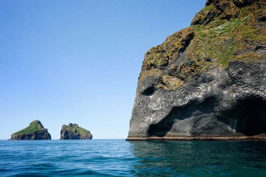
ในขณะที่เรือแล่นอยู่ในมหาสมุทรแอตแลนติก คุณจะได้เห็นสถานที่สวยๆ หลายแห่งที่น้อยคนจะมีโอกาสได้มาเห็น เช่น คุณจะได้เข้าไปชมถ้ำริมชายฝั่ง 5 แห่ง หนึ่งในนั้นคือถ้ำแคลทเชลลีร์ (Klettshellir) ที่มีเสียงก้องกังวาน
และคุณยังจะได้เห็นหินรูปร่างแปลกประหลาดที่บนหน้าผาด้วย ซึ่งหินนี้มีรูปร่างคล้ายกับใบหน้าของช้าง
ทัวร์นี้น่าจะถูกใจคนรักสัตว์เป็นอย่างมาก เพราะหากมากับทัวร์นี้ก่อนเดือนกันยายน คุณจะได้เห็นนกพัฟฟินแอตแลนติกนับพันๆ ตัวมาทำรัง ซึ่งหมู่เกาะเวสท์แมนมีอัตราส่วนประชากรนกน้อยน่ารักน่าเอ็นดูเหล่านี้มากที่สุดในโลก และนกพัฟฟินเป็นนกที่มีคู่ตัวเดียวตลอดชีวิตและพวกมันจะอยู่เคียงข้างกันเป็นคู่ๆ ตามเกาะเล็กเกาะน้อยและบนโขดหิน เพื่อช่วยกันปกป้องโพรงที่ทำรัง นอกจากนี้คุณยังอาจจะได้เห็นพวกมันตามผืนน้ำขณะที่เจ้านกกำลังออกหาอาหารด้วย
เรือสปีดโบ๊ทสามารถพาคุณเข้าไปชมนกพัฟฟินได้อย่างใกล้ชิดโดยที่ไม่ทำให้พวกมันตกใจ ซึ่งคุณจะได้ชื่นชมสีสันและความน่ารักของพวกมันได้อย่างเต็มที่
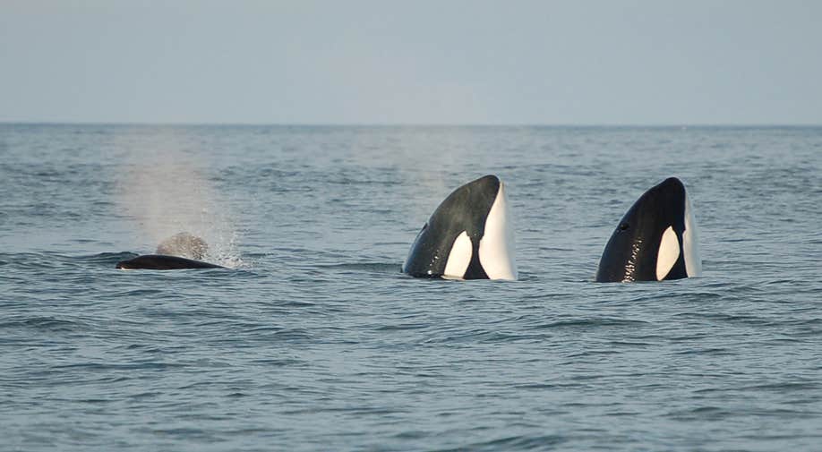
นอกจากนี้คุณยังมีโอกาสได้เห็นวาฬในทริปนี้ด้วย เพราะหมู่เกาะเวสท์แมนมีน่านน้ำที่อุดมสมบูรณ์และมีสัตว์น้ำมากมาย จึงดึงดูดวาฬหลายสายพันธุ์ โดยเฉพาะวาฬออร์กา และวาฬฟินซึ่งเป็นสายพันธุ์ที่มีขนาดใหญ่เป็นอันดับสองของวาฬที่เคยมีบนโลกใบนี้ และแน่นอนว่าคุณอาจจะได้เห็นวาฬสีน้ำเงิน วาฬมิงค์ และวาฬหลังค่อม รวมถึงโลมาปากขาวและฮาร์เบอร์พอร์พอยส์ด้วย
ร่วมเดินทางไปชมชีวิตสัตว์น้อยใหญ่ของเกาะเวสท์มานนาเอยาร์ด้วยทัวร์ล่องเรือที่ออกเดินทางจากไฮมาเอย์ด้วยกัน ตรวจสอบจำนวนที่ว่างของทัวร์นี้ได้โดยระบุวันเดินทางที่คุณต้องการ


