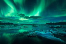

Ватнайёкюдль (исл. Vatnajökul) – крупнейший ледник Европы. Он покрывает восемь процентов всей суши Исландии.
По Ватнайёкюдлю из-за его огромных размеров проходит много различных автотуров, пакетов и экскурсий, в том числе экскурсий по южному побережью. Так, многие уголки Ватнайёкюдля можно увидеть в рамках 10-дневного летнего автотура и 6-дневных летних каникул. Также ледник можно исследовать, арендовав автомобиль.
Ледник является сердцем одноименного национального парка Ватнайёкюдль на юго-западе Исландии. Это очень красивое место, которое пользуется неизменным спросом благодаря походам на ледник Скафтафедль, лодочным турам по ледниковой лагуне Йёкюльсаурлоун и экскурсиям в ледяные пещеры в период с ноября по март.
Факты о леднике Ватнайёкюдль
Площадь ледника Ватнайёкюдль составляет примерно 8100 квадратных километров. Из-за изменения климата он быстро тает, но медленнее, чем другие ледники, такие как Лаунгйёкюдль и Мирдальсйёкюдль.
Средняя толщина льда составляет примерно 500 м, а в некоторых точках превышает 1000 м.
Под снежным одеялом ледника скрывается высочайшая вершина Исландии – пик Хваннадальсхнукюр высотой 2200 м. Также под ледником находится целый ряд действующих вулканов, самые известные из которых: Гримсвётн, Эрайвайёкюдль и Баурдарбунга.
Вулканическая активность в этом регионе в той или иной степени непрерывно продолжается веками. Многие геологи считают, что ряд извержений уже должны произойти, но пока не произошли. Если их расчеты верны, это означает, что в ближайшие примерно 50 лет Ватнайёкюдль ждет серьезная вулканическая активность.
Вулканы Баурдарбунга и Гримсвётн уже извергались в XXI веке.
При определенном направлении ветра такие извержения могут оказывать серьезное воздействие на авиасообщение, сельское хозяйство и климат, выходящее далеко за пределы региона. Именно так было с вулканом Эйяфьядлайёкюдль в 2010 году.
Ледник Ватнайёкюдль включает в себя свыше 30 выводных ледников (языков) – протоков из льда, которые как бы текут с ледяной шапки и накапливаются на краях долины.
Крупнейшие такие выводные ледники: Дингьюйёкюдль на севере; Брейдамеркурйёкудль; Скейдараурйёкюдль на юге; Сидюйёкюдль, Скафтарйёкюдль и Тунгнаарйёкюдль на западе.
Из ледника Ватнайёкюдль вытекает много рек, в том числе некоторые крупнейшие ледниковые реки Исландии. Самые известные из них:
-
Тунгна (запад)
-
Кёлдюквисль (запад)
-
Тьёрсау (запад)
-
Йёкюльсау-ау-Фьёдлюм (север)
-
Скьяульвандафльоут (север)
-
Йёкюльсау-ау-Брю (северо-восток)
-
Йёкюльсау-и-фльоутсдаль (северо-восток)
-
Йёкюльсау-и-Лоуни (юг)
-
Хорнафьярдарфльоут (юг)
-
Йёкюльсау-ау-Брейдамеркюрсанди (юг)
-
Скейдарау (юг)
-
Нюпсвотн (юг)
-
Хверфисфльоут (юг)
-
Скауфау (юг)
Национальный парк Ватнайёкюдль

Национальный парк Ватнайёкюдль был учрежден в июне 2008 года, и с тех пор он расширялся и включал в себя дополнительные территории. Сегодня он охватывает площадь в 14141 кв. км, что составляет 14 % от общей площади страны. Это второй по размеру национальный парк в Европе и один из трех объектов всемирного наследия ЮНЕСКО в Исландии.
В состав национального парка входят области, которые раньше были самостоятельными национальными парками, такие как Скафтафедль, а также зоны, которые недавно получили защиту, такие как Йёкюльсаурлоун.
К северу от парка горное плато делится на две части реками. Над этой местностью возвышается вулканическая столовая гора Хердюбрейд с вулканами Аскья, Снайфедль и Кверкфьёдль.
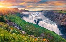
Много веков назад ледниковые потоки прорезали здесь каньон Йёкюльсаургльювюр. В верхней его части находится Деттифосс – второй по мощности водопад в Европе.
Совсем рядом расположены еще два впечатляющих водопада: Сельфосс и Хаврагилсфосс.
Если двигаться дальше на север, вы окажетесь у каньона Аусбирги, напоминающего по форме подкову. Согласно легенде, каньон появился от удара копыта восьминогого коня Слейпнира бога Одина.
К востоку от Снайфедля находится заболоченная местность, где пасутся стада диких северных оленей и водится много птиц. Южная граница Ватнайёкюдля представляет собой крутую горную гряду, и выводные ледники оттуда проникают далеко вниз, в долину. Еще южнее расположена обширная песчаная пустыня Скейдараурсандюр, через которую протекает ледниковая река Скейдарау.
Одна из самых популярных точек национального парка – ледниковая лагуна Йёкюльсаурлоун у основания выводного ледника Брейдамеркурйёкудль. По этому огромному водоему дрейфуют айсберги, отколовшиеся от ледника, и затем либо попадают в Атлантический океан, либо прибиваются к берегу ближайшего Бриллиантового пляжа.
И это одно из лучших в стране мест, где можно увидеть тюленей.
Будущее Ватнайёкюдля

Объем снежного покрова Ватнайёкюдля достиг своего максимума примерно в 1930 году, но с тех пор он планомерно снижается из-за глобального потепления. За последние 15 лет толщина ледника уменьшается примерно на 1 метр в год.
Если температура будет продолжать расти, ледник может полностью исчезнуть к концу следующего века. Останутся только небольшие снежные шапки на вершинах самых высоких гор.
Сейчас предпринимаются попытки спасти ледник, хотя есть мнение, что это уже невозможно. Один из проектов – лесопосадки вокруг ледника. Это проверенный метод охлаждения территории. Лишь время покажет, насколько это успешно.
Ватнайёкюдль и Йёкюльсаурлоун в популярной культуре
Красота национального парка Ватнайёкюдль не осталась незамеченной киноиндустрией. Здесь снимался целый ряд известных фильмов: «Джеймс Бонд: вид на убийство» (1985), «Бэтмен: начало», «Лара Крофт: расхитительница гробниц», «Невероятная жизнь Уолтера Митти», «Джеймс Бонд: умри, но не сейчас». Водопад Деттифосс появляется в фильме «Прометей» 2012 года.
Однако, пожалуй, самые известные сцены с ледником Ватнайёкюдль фигурируют в сериале HBO «Игра престолов», где на них разворачиваются события к северу от Стены. Сама же Стена нарисована с помощью компьютерной графики с использованием кадров с ледником.
Как добраться до ледникаВатнайёкюдль
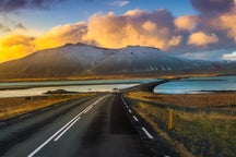
До ледника Ватнайёкюдль легко добраться из Рейкьявика на арендной машине, путешествуя вдоль южного побережья. До Скафтафедля, по языкам которого ходят в походы, от столицы 327 км, при этом многие из его языков можно увидеть с Кольцевой дороги прямо из окна автомобиля.
Главные объекты национального парка Ватнайёкюдль, такие как ледниковая долина Йёкюльсаурлоун, водопад Деттифосс и каньон Аусбирги, также находятся вблизи Кольцевой дороги (она же трасса № 1) на одном из ее съездов.