Disponibilité limitée
Faites des économies en réservant tôt
Meilleur prix garanti
Sans frais de réservation ajouté
Autotour de 6 jours petit budget | Les incontournables du Sud
Partez découvrir les incontournables du Sud de l'Islande lors de ce voyage autotour petit budget de 6 jours / 5 nuits.
Lors de cette petite semaine dans la Terre de glace et de feu vous découvrez des paysages variés et à couper le soufle dont des geysers, glaciers, plage volcanique et la lagune de Jokulsarlon.
Vous logez dans des hébergements simples et prenez la route dans une voiture standard pour vous permettre de voyager à petit prix et profitez de ce qui est vraiment important : les paysages !
Vous pouvez également ajouter des activités à votre voyage pour pimenter celui-ci avec une randonnée sur glacier, une balade à cheval, une visite d'une grotte de glace, une session motoneige sur glacier ou la visite de l'intérieur d'un volcan.
Réservez-vite ce voyage de 6 jours/5 nuits à la découverte du Sud de l'Islande en petit budget ! Cliquez sur "choisir une date" et sélectionnez le nombre de participants pour voir le prix et réserver votre voyage.
Bon à savoir
- Disponible : Avr. - Aoû.
- Durée : 6 jours
- Activités : Rando glacier, Snorkeling , Motoneige , Balade à cheval , Baleines, Visite naturelle, Bateau, Sources chaudes, Visite culturelle, Oiseaux, Voyage autotour
- Difficulté : Facile
- Lieux phares : Blue Lagoon,
The Blue Lagoon is a geothermal spa found on the Reykjanes Peninsula in southwest Iceland. It is the most popular attraction in Iceland drawing people from all across the world.
The Lagoon is just a fifteen-minute drive from Keflavík International Airport, or a thirty-minute drive from Reykjavík, located between the two. It is thus often visited straight after arrival to the country or right before departure.
There are few better ways to recharge after a long-flight or action-packed holiday.
History
The Blue Lagoon started as a pool of wastewater from the Svartsengi geothermal plant in 1976. The first person to bathe there was Valur Margeirsson in 1981. He was met with some resistance prior to taking the first dip as people thought he was mad for wanting to bath in a "blue mud pool". He and others soon began to notice the unusual but remarkable healing qualities of the azure waters.
Those with conditions such as psoriasis found the waters immediately soothing for their condition. News quickly spread, and by 1987, the first swimming facilities were officially opened.
Since then, the establishment has only grown, from an open pool with no surrounding buildings to a luxurious spa, research centre and hotel.
Today
The Blue Lagoon is considered to have such notable regenerative qualities because the water is rich in silica and sulphur. A research and development facility on site finds cures and remedies for skin ailments, and silica mud is available for free on the sides of the pool for guests to enjoy a facemask.
The temperature in the bathing and swimming area is very comfortable, averaging 37–39° C (98–102° F). The Blue Lagoon also boasts the LAVA Restaurant, the Blue Café and the Lagoon Spa: you can thus enjoy cocktails, health products, delicious meals and treatments such as massages without leaving the premises. Saunas, steam rooms and a small waterfall are also on site.
For all of these reasons and more, the Blue Lagoon is considered to be one of the most enjoyable and romantic spots in the country. It is surrounded by a plethora of fantastic volcanic landscapes, and the water itself is opaque and vividly blue. Rising pillars of steam only add to the spa’s fantastic ambience.
Things to Note
The Blue Lagoon Spa is open throughout the year, and popular in every season. Due to the fact it has a maximum capacity for the comfort of its guests, it is essential that you book several months in advance to ensure your space. The vast majority of the time, you will be turned away at the door without a reservation.
More reserved guests might want to be aware that it is a requirement to shower naked in public before entering the lagoon, to ensure that the highest hygiene standards are maintained. Though uncomfortable for some, nudity has little taboo in Icelandic culture, so worry not; no-one’s looking.
Those who are travelling on a budget will note that the Blue Lagoon is quite pricey. There are other smaller spas and pools that can be entered for less, such as the Fontana Spa, Secret Lagoon, Mývatn Nature Baths and Krauma Spa. Of course, natural hot pools are free to enter.
For more information, you can read articles on the best pools in the country and the best natural hot springs.
Cercle d'Or,The Golden Circle is a 300 kilometre (186 mile) route to the three most popular natural attractions in Iceland: the Geysir Geothermal Area, Gullfoss Waterfall and Þingvellir National Park.
This sightseeing trail is easy to do within half a day from Reykjavík, either by self-drive or on one of many tours. Some of these tours have additional activities, such as snorkelling or snowmobiling, or are conducted in a unique style, such as by helicopter, or under the midnight sun.
Within the three locations of the Golden Circle are some of the clearest examples of Iceland’s fascinating geological forces, magnificent landscapes, and rich culture.
The Geysir Geothermal Area
The Geysir Geothermal Area is a hot-spring haven in Haukadalur Valley. As could be guessed, it is home to a famous geyser, the name of which has named all others: Geysir itself.
Though this feature is currently in a phase of inactivity, its neighbour Strokkur more than makes up for it. Every five to ten minutes, it blasts a column of boiling water to heights that can reach over 40 metres (131 feet).
The surrounding area is dotted with fumaroles, hot springs, and mud-pits. There are also two other smaller geysers, Smiður and Litlí-Strokkur, that can be easily visited, as well as a hotel, restaurant, cafe and gift shop across the road.
Gullfoss Waterfall
The 'Golden Waterfall', Gullfoss one of the most beautiful and powerful waterfalls in Iceland, plummeting 32 metres (105 feet) in two tiers into the river gorge of the popular rafting river Hvítá. It is just a ten-minute drive from Geysir and is the furthest point on the Golden Circle from Reykjavík.
Gullfoss was very almost lost in the early 20th century when British developers sought to harness its incredible power for geothermal energy. Though they got the lease to the land, allowing them to go ahead with their plans, they met an unlikely adversary: the daughter of the farmer who owned it, Sigríður Tómasdóttir.
This resilient woman refused to see the waterfall, to which she and her sisters paved the first path, destroyed. She, therefore, walked over 200 kilometres (124 miles) to Reykjavík and back multiple times to meet with a lawyer in order to help change the decision.
Though the process was arduous and took years, eventually Sigríður managed to exhaust the resources of the businessmen and they withdrew their plans. Because of her, all Icelandic waterfalls are now protected from foreign investors, and she is considered one of Iceland’s first environmentalists and most important historical people.
Thingvellir National Park
The largest attraction of the Golden Circle is Þingvellir National Park. The Icelandic parliament was founded here in 930 and remained until the year 1798 before moving to Reykjavík, making it the original site of what is now the world’s longest ongoing parliament.
Today it is a UNESCO World Heritage Site and one of the most important places to visit in Iceland. This is not just for its historical and cultural values, but for also its magnificent landscape and dramatic geology.
Þingvellir is surrounded by a beautiful mountain and volcanic ranges, as it is located in a rift valley directly between the North American and Eurasian tectonic plates. This makes it one of the few places in the world where you can walk between the continents, in the Mid-Atlantic Rift.
The daring and qualified even have opportunities to snorkel or scuba dive in this no-mans-land, in a ravine filled with crystal-clear spring water called Silfra. The visibility here can exceed 100 metres (328 feet), revealing incredible geological sites. Though it never freezes over due to the constant flow of water into it, it is 2°C (35°C) throughout the year, thus underwater explorers are always equipped with protective suits.
Other sites of note are the magnificent Almannagjá gorge, which you can walk down into to reach the rift valley from the North American tectonic plate, and the beautiful lake Þingvallavatn, the largest lake in Iceland, which gleams to the south of the National Park.
Surrounding sites
Due to its convenient location in south-west Iceland, it is easy to visit the Golden Circle alongside with many other sites. Those seeking relaxation could head to the Secret Lagoon in Flúðir or Fontana Spa in Laugarvatn, those seeking adventure could book a trip to the ice tunnels of Langjökull glacier, and those seeking culture could visit the Sólheimar ecovillage. For more natural beauty, you can visit the nearby Kerið crater lake.
There are many tours that include such bonuses, but if driving yourself, you should check out this guide to great detours off the Golden Circle.
Reykjavík,Reykjavík is the capital of Iceland and the northernmost capital of any sovereign state in the world.
Despite a small population (approximately 120,000, with just over 200,000 in the Greater Reykjavík area), it is a vibrant city that draws an ever increasing number of visitors every year. It is the financial, cultural and political centre of Iceland, and has a reputation of being one of the cleanest and safest cities in the world.
Geography
The city of Reykjavík is located in southwest Iceland by Faxaflói Bay. Throughout the ages, the landscape has been shaped by glaciers, earthquakes and volcanic eruptions and the area is geothermal; after all, its name translates to ‘Smoky Bay’.
Much of the current city area was subglacial during the Ice Age, with the glacier reaching as far as the Álftanes peninsula, while other areas lay under the sea. After the end of the Ice Age, the land rose as the glaciers drifted away, and it began to take on its present form.
The coastline of Reykjavík is set with peninsulas, coves, straits and islands, most notably the island of Viðey, and seabirds and whales frequent the shores. The mountain ring as seen from the shore is particularly beautiful.
Mount Esjan is the highest mountain in the vicinity of Reykjavík and the most distinctive feature of the coastline. This majestic summit is also highly popular amongst hikers and climbers. Other notable mountains that can be seen from the seaside are Akrafjall and Skarðsheiði.
On clear days, one may even see as far to the legendary Snæfellsjökull glacier, at the end of the Snæfellsnes peninsula.
The largest river to run through the city is Elliðaá in Elliðaárdalur valley, which is also one of Iceland’s best rivers for salmon fishing.
Transportation
There are no trains or trams in Iceland, but most people travel by car. The city also operates a bus system. There are two major harbours in town, the old harbour in the centre and Sundahöfn in the east.
The domestic Reykjavík Airport is located at Vatnsmýrin, not far from the city centre and close to the hill Öskjuhlíð and the restaurant, vantage point and exhibition centre Perlan. The international Keflavík Airport at Miðnesheiði heath then lies around 50 kilometres (31 miles) from the city.
Cars, jeeps and bicycles can be readily rented in the city and many organized tours are also being offered. It is, however, quite easy to walk between the major sites.
What to See & Do in Reykjavik
The local arts scene is strong in Iceland, with annual events and festivals, many of artists from which have hit the international stage.
Major events taking place in Reykjavík include Iceland Airwaves, Reykjavík Pride, RIFF (The Reykjavík International Film Festival), The Reykjavík Literature Festival, Culture Night, the Reykjavík Arts Festival, Food & Fun, the Reykjavík Fashion Festival and the Sónar music festival.
Amongst the famous people from Reykjavík are musicians like Björk Guðmundsdóttir and Sigur Rós, and writers Halldór Laxness (born on the main street, Laugavegur) and Arnaldur Indriðason.
Those eager to soak up the local culture should visit the city’s many museums, exhibitions and galleries, and check out live music at the cafés, bars, and concert venues dotted around. You could look at the programmes of what’s on at the Harpa music hall or the theatres, or else plan a few hours at the lighthouse at Grótta, the shopping street of Laugavegur, or the old harbour and the flea market.
You could even book a bird- and whale watching tour or a visit to Viðey island. There are a lot of things to do and the possibilities are endless.
Make sure to visit the public square of Austurvöllur, one of the city’s most popular gathering places, where you’ll also find the national parliament, the Alþingi, as well as the state church, a statue of independence hero Jón Sigurðsson, cafés, bars and restaurants.
Austurvöllur was central in the protests following the banking collapse of 2008, along with Lækjargata, home to the House of Government. You are also not likely to miss the great church of Hallgrímskirkja that towers over the city from the hill of Skólavörðuholt, from which you’ll get a great view of the city.
Try a walk by the city pond, Tjörnin, to greet the many birds that frequent the area and to visit the city hall, stationed by its banks. A beautiful park lies by the pond, ideal for a nice walk, and sometimes concerts get held there.
Further off is the campus of the University of Iceland, the Nordic house and the Vatnsmýrin wetland, a particularly pleasant place, but be mindful to not disturb the wildlife there by keeping to the pathways.
For a nice swim on a warm day, we particularly recommend Nauthólsvík beach, which is heated with geothermal water. Those who love a dip should also visit the Laugardalur valley, home to one of the city’s best swimming pools, which sits a short walk away from Ásmundarsafn gallery, a beautiful botanical garden and a domestic zoo.
A walk by the Ægissíða beach, with its old fishing sheds, in the west part of Reykjavík also holds a particular charm. From there, you can see all the way to president’s house at Bessastaðir, which is also a historical site in its own right, having been the educational centre of Iceland for centuries.
Another place that offers one of the city’s best views is Perlan, up on Öskjuhlíð hill. The hill itself is a popular place to spend a few hours, with over 176,000 trees and great opportunities for walking and cycling. Perlan also has and observation deck with great views, a café and an exhibition centre.
Furthermore, the city is a short drive from many of Iceland’s major attractions, most famously the Golden Circle and the Blue Lagoon. In close vicinity you’ll also find the Heiðmörk preservation area, a favourite local site of the people of Reykjavík, as well as the Blue Mountains, one of Iceland’s best skiing venues.
Finally, we’d like to stress that these are only some suggestions of the many things you might check out in Reykjavík. Whatever you choose to do, we hope you’ll be able to make the most of your visit and we wish you a pleasant stay in our capital.
Jokulsarlon,Jökulsárlón is Iceland’s most famous glacier lagoon. Conveniently located in the southeast by Route 1, about halfway between the Skaftafell Nature Reserve and Höfn, it is a popular stop for those travelling along the South Coast or around the Ring Road of the country.
Geography
As a glacier lagoon, Jökulsárlón is a lake that is filled with the meltwater from an outlet glacier. In this case, it is Breiðamerkurjökull, a tongue of Europe’s largest ice cap, Vatnajökull.
It stands out, however, due to the fact that it also fills with icebergs breaking from the glacier, some of which tower several stories high.
These icebergs, other than their scale, are notable for their colouration. Although they are, as expected, largely white, most are also dyed electric blue in part, with black streaks of ash from eruptions centuries past.
When the icebergs finally make it across the lagoon, they either drift out to sea or wash up on the nearby shore. Because of the way they glisten against the black sands of Breiðamerkursandur, this area has been nicknamed ‘the Diamond Beach’.
In spite of being a rather recent formation, Jökulsárlón is the deepest lake in the country, with depths of 248 metres (814 feet). With a surface area of 18 square kilometres (7 square miles), it is also growing to be one of the largest.
History
Jökulsárlón has not been around since Iceland’s settlement; it only formed around 1935. This was due to rapidly rising temperatures in the country from the turn of the twentieth century; since 1920, Breiðamerkurjökull has been shrinking at a dramatic rate, and the lagoon has begun to fill its space.
Today, the expansion of Jökulsárlón is accelerating. In 1975, it had less than half its current surface area.
In the relatively near future, it is expected that the lagoon will continue to grow until it becomes a large, deep fjord.
Though a dark omen for Iceland’s glaciers and ice caps in general, the retreat of Breiðamerkurjökull has resulted in an incredibly beautiful, if temporary, site. This has not been overlooked by Hollywood.
Jökulsárlón has been featured in the James Bond films A View to Kill in 1985 and Die Another Day in 2002, 2001’s Lara Croft: Tomb Raider, and 2005’s Batman Begins.
In 2017, Jökulsárlón was enveloped into the Vatnajökull National Park, thus it is now fully protected by Icelandic law.
Wildlife
Because of the wealth of herring and capelin that the tides bring into the lagoon, Jökulsárlón is somewhat of a hot-spot for Iceland’s wildlife.
In summer, it is a nesting site for Arctic Terns; stay well away from their nesting area, as these birds are notorious for the fierceness with which they protect their eggs, dive-bombing the heads of any they see as a threat. Skuas also nest on the lake’s shores in this season.
Seals can be reliably spotted here throughout the year, swimming amongst or else hauling out on the icebergs. Jökulsárlón provides them with a safe haven to rest and socialise, especially considering the waters of southeast Iceland are renowned for their population of orcas.
Vatnajökull,Vatnajökull glacier is the largest glacier in Europe, covering 8% of Iceland’s landmass.
It is the central feature of the Vatnajökull National park, found in the south west of Iceland, a popular spot for activities like glacier hiking from Skaftafell, boat tours in the Jökulsárlón glacier lagoon, and ice caving tours between November and March.
Facts about Vatnajokull
Vatnajökull has a surface area of approximately 8,100 square kilometres (3127 square miles); though it is rapidly shrinking due to climate change, its recession is not quite as advanced as at other glaciers, such as Langjökull and Mýrdalsjökull. In parts, it is a kilometre deep (over three thousand feet), and its average thickness is around half of that.
Vatnajökull also holds the tallest peak in Iceland beneath its ice; Hvannadalshnjúkur is 2,200 metres tall (7,218 feet). It also conceals some of the most active volcanoes in the country, the most notable being Grímsvötn, Öræfajökull and Bárðarbunga.
Volcanic activity in the region has occurred on and off throughout the centuries, and many geologists believe that several eruptions are overdue. If their calculations are correct, it would mean significant volcanic activity for Vatnajökull over the scope of the next half-century.
Depending on winds, this could result in worldwide consequences in terms of air-travel, agriculture and the general climate.
The glacier boasts over 30 outlet glaciers, which are channels of ice that flow out of ice caps but remain constrained on the sides of the valley. The major outlet glaciers of Vatnajökull include Dyngjujökull in the north, Breiðamerkurjökull, and Skeiðarárjökull to the south. To the west, one can find the outlet glaciers Síðujökull, Skaftárjökull and Tungnaárjökull.
Numerous rivers run out of Vatnajökull, making up some of the greatest glacial rivers in Iceland. The most notable are:
Tungnaá (west)
Köldukvísl (west)
Þjórsá (west)
Jökulsá á Fjöllum (north)
Skjálfandafljót (north)
Jökulsá á Brú (northeast)
Jökulsá í Fljótsdal (northeast)
Jökulsá í Lóni (south)
Hornafjarðarfljót (south)
Jökulsá á Breiðamerkursandi (south)
Skeiðará (south)
Núpsvötn (south)
Hverfisfljót (south)
Skaftá (south)
Vatnajokull National Park
Vatnajökull National Park was established in June 2008 and has slowly grown to include more and more areas. The park now covers an area of 14,141 square kilometres (5,460 square miles), 14% of the country. It is the second largest national park in Europe.
Rivers divide the highland plateau to the north of the park. The volcanic table mountain Herðubreið towers over this particular region, along with volcanoes Askja, Snæfell and Kverkfjöll.
The canyon Jökulsárgljúfur was carved out by glacial floods centuries ago. At the upper end of the canyon, you'll find Dettifoss, the most powerful waterfall in Europe. Further north, the horseshoe-shaped canyon Ásbyrgi is believed to have formed when Óðinn's eight-legged horse, Sleipnir, stepped his foot down from the heavens.
East around Snæfell, one can find wetlands and ranges, home to roaming herds of wild reindeer and abundant birdlife. Steep mountain ridges make up the south side of Vatnajökull, where outlet glaciers crawl onto the lowlands. The sandy plains of Skeiðarársandur also lie to the south, and the glacial river Skeiðará runs through this vast desert.
One of Iceland's most visited landmarks in the National Park is the Jökulsárlón glacier lagoon, which sits at the base of the outlet glacier Breiðamerkurjökull. Here, large icebergs that have broken off the glacier float across a vast lake before ending up in the Atlantic Ocean, or washed ashore on the nearby Diamond Beach.
This is one of the best seal-watching spots in the country.
The Future of Vatnajokull
The volume of Vatnajökull reached its peak around 1930 but has since been in a steady process of decline. Because of rising levels of global temperature, Vatnajökull has on average lost about a metre (three feet) of its thickness annually over the past 15 years.
If temperature levels continue to rise, the glacier could be all but gone nearing the end of the next century, leaving only small ice caps on top of the highest mountain summits.
Efforts are being made to prevent what some say is the inevitable, with reforestation projects going on all around the glacier, a proven method of cooling the area. Time will tell how successful they are.
Vatnajokull and Jokulsarlon in Popular Culture
The beauty of Vatnajökull National Park has not gone unnoticed by those in film or television. Many famous scenes have been shot here, starting with James Bond: A View to Kill in 1985. Other notable films with scenes here include Batman Begins, Lara Croft: Tomb Raider, and James Bond: Die Another Day.
Most famously, however, many places in Vatnajökull have been used in the HBO Series Game of Thrones, north of the Wall. The Wall itself is constructed with CGI using shots of the glacier.
Skógafoss,Skógafoss is one of Iceland’s biggest and most beautiful waterfalls with an astounding width of 25 meters (82 feet) and a drop of 60 meters (197 feet).
Due to the amount of spray the cascade produces, at least one rainbow is present any time the sun emerges from behind the clouds.
Located on the Skógá river, this mighty cascade is clearly visible from Route 1 and is an excellent place to stop and stretch the legs while travelling Iceland’s South Coast. The river below Skógafoss holds a large char and salmon population and is thus a favourite spot for fishermen in the summer.
The land underneath the waterfall is very flat, allowing visitors to walk right up to the wall of water. This will get you drenched, although, on a summer’s day, it can be quite tempting.
Skógafoss can also be viewed from the top as a steep staircase leads to an observational platform above the cascade. Many nesting seabirds can be found on the route up.
Geography
Skógafoss is located near the small village of Skógar, south of the Eyjafjallajökull glacier volcano. There you’ll find the Skógasafn folk museum, an open-air museum with both old wooden houses and turf houses, as well as a regional museum with various artefacts from this area.
A part of the Skógasafn Regional Museum is the Museum of Transportation, which showcases the history and evolution of transportation, communication and technologies in Iceland. There, you can see how this nation evolved from the age of the working horse to the digital communications of the 21st century.
The Skógasafn museum also includes a café and a museum shop, and in the village of Skógar, you will find both a hotel and a restaurant.
At the eastern side of Skógafoss, you will find one of Iceland’s most famed hiking routes; the Fimmvörðuháls pass. The 22 kilometre (14 miles) trail takes you along Skógá river, between two glaciers, Mýrdalsjökull and Eyjafjallajökull, before ending in the beautiful Þórsmörk valley.
Skógafoss is often visited alongside the waterfall Seljalandsfoss, which is just a little further along the South Coast. Both fall from cliffs of the same height, and while Skógafoss is much more powerful, Seljalandsfoss has a cave behind it, which means it can be fully encircled. It is also next to a much lesser known but still awe-inspiring waterfall, Gljúfrabúi.
Folklore
A gold ring is on display at the Skógasafn museum. According to legend, the ring is from a chest that was owned by Þrasi Þórólfsson, one of the first Viking settlers in the area, who by some accounts was a giant. Folklore states that before his death in 900 AD, Þrasi buried a chest filled with gold in a cave behind Skógafoss waterfall.
Many attempts were made to retrieve the chest after Þrasi’s death, and years later, locals managed to grasp a ring on the side of the chest. As they pulled, the ring broke off, and the treasure was lost forever. The ring was then given to the local church before it made its way to the museum.
Seljalandsfoss,Seljalandsfoss is a waterfall that can be fully encircled, situated on the South Coast of Iceland with a drop of 60 metres (200 feet).
Due to the waterfall’s close proximity to the Ring Road and impressive natural features, it is one the country's most famous and visited falls. Majestic and picturesque, it is one of the most photographed features in all of Iceland.
Geology and Surroundings
Seljalandsfoss waterfall, part of the river Seljalandsá, has its origins underneath the glacier Eyjafjallajökull. The volcano beneath this ice cap was the one that erupted in 2010 and caused havoc at airports across Europe.
The cascade of the falls is relatively narrow but falls from a tall cliff that once marked the country's coastline, the sea is now located across a stretch of lowlands and is visible from the site.
The most distinguishing feature of Seljalandsfoss is a pathway that stretches all the way around it. The cliffs behind the falls have a wide cavern, and rocks and paths allow guests to fully encircle it in summer.
Though a mesmerising opportunity, visitors should be prepared to get dampened due to the perpetual mist of the falls, which also tends to make the rocks of the pathway slippery.
Floodlights have been set up on both sides of the waterfall, which impressively illuminate the scene during the night when the midnight sun is not out. The lights were installed in 2001 due to the growing popularity of the falls as a tourist destination.
After visiting Seljalandsfoss, it is common for visitors to continue north to the waterfall Gljúfrabúi, which is found partially hidden behind a rock face. Because of Seljalandsfoss extreme popularity, Gljúfrabúi is widely considered the hidden gem of the scene, as it is too often overlooked.
Seljalandsfoss is also usually visited alongside the nearby Skógafoss. The waterfall falls from the same height, and while it cannot be encircled, it is much more powerful and steeped in the legend of a giant’s hidden treasure.
Visitor Centre Controversy
In 2017, it was announced that a visitor’s centre was to be constructed near the falls. The design of the building indicated that it would be seven metres (23 feet) high and 2,000 square metres (21,500 square feet) in size. Landowners in the area opposed to the idea, proclaiming that the centre would greatly alter the natural appearance of the waterfall’s renowned scenery.
The project has neither been fully approved nor wholly cancelled, with ideas surfacing of either significantly reducing the size of the construction, or moving the visitor centre’s location further away, for instance to the nearby farmstead Brekkuhorn.
Seljalandsfoss in Popular Culture
Along with a multitude of South Iceland’s most famous natural attractions, Seljalandsfoss can be seen in Justin Bieber’s music video for his song ‘I’ll Show You’. Please enjoy the video without emulating any antics that will endanger yourself or the environment.
The waterfall was also a featured waypoint during the first leg of the sixth season of The Amazing Race, an American reality TV series.
Geysir,Geysir is a famous hot spring in the geothermal area of Haukadalur Valley, found in south-west Iceland.
Making up just one of the attractions along the world-renowned Golden Circle sightseeing route, alongside Þingvellir National Park and the mighty Gullfoss waterfall, Geysir is most well-known for having lent its name to geysers all around the world.
Geography
Though Geysir itself is rarely active these days, Haukadalur Valley boasts a plethora of hot springs and geysers, including the powerful Strokkur, Smiður and Litli-Strokkur.
Strokkur is, arguably, the country’s most famous hot spring, shooting vast jets of boiling water from 20 metres (65 feet) up to 40 metres (130 feet) high. Don’t worry about missing this incredible spectacle of nature, as Strokkur erupts every five to ten minutes; just make sure to have your camera ready.
Geysir is much larger, but years can go by between eruptions here; it is currently in an inactive phase. When it does erupt, the water can shoot up in the air as high as 70 metres (230 feet).
Just a few minutes walk north of Geysir are a wealth of fumaroles emanating steam and gas into the cool Icelandic air. Aside from watching the hypnotic pillars of steam, you will also be able to observe the yellow sulphuric stains along the fumaroles themselves, a result of the earth’s minerals crystallising around the rock bed.
At the southern part of the valley, Þykkuhverir, you’ll find various bubbling mud pots. These spooky brown cauldrons are actually fumaroles that boil up through the loose ground; after a dry spell, these mud pools are likely to transform into a hardened fumarole.
Nearby Attractions
About two kilometres (one mile) from Geysir is a preserved natural pool called Kúalaug. It has room for three to five people at a time, but care should be taken, as the area around the pool is very delicate. The temperature is 39-43°C (102-109°F), depending on where you are positioned in the pool.
The water is slightly muddy, as the pool is built on soil, and the bottom is slippery due to algae, so caution is advised when relaxing here.
Haukadalur has also seen a rise in reforestation in recent times thanks to continued experiments and research in the area. Today, Haukadalsskógur is one of the largest forests in south Iceland, boasting accessible walking paths (also for wheelchair users), fascinating vegetation and The Tree Museum, built in the memory of forester Gunnar Freysteinsson.
History
Haukadalur has been inhabited and used as a church site since the Age of Settlement. Given its historic value, it should be noted that scholar, Ari “The Wise“ Þorgilsson, grew up here; it was also where the first pastoral school in Iceland was built.
The current wooden church was last rebuilt in 1938 but its architectural style dates back to 1842, making it well worth a visit to see how Iceland looked before industrialisation.
For accommodation, Hotel Gullfoss is approximately 7 kilometre from the Geysir area, and closer still is Hotel Geysir on the other side of the road from the attraction, where you will also find a restaurant, café and a souvenir shop.
Gullfoss,Gullfoss (translated to ‘Golden Falls’) is one of Iceland’s most iconic and beloved waterfalls, found in the Hvítá river canyon in south-west Iceland.
The water in Hvítá river travels from the glacier Langjökull, before cascading 32 meters (105 feet) down Gullfoss’ two stages in a dramatic display of nature’s raw power. This incredible site is seen by most visitors, as it is on the Golden Circle sightseeing route.
Because of the waterfall’s two stages, Gullfoss should actually be thought of as two separate features. The first, shorter cascade is 11 metres (36 feet), whilst the second drop is 21 metres (69 feet). The canyon walls on both sides of the waterfall reach heights of up to 70 metres (230 feet), descending into the great Gullfossgjúfur canyon. Geologists believe that this canyon was formed by glacial outbursts at the beginning of the last age.
In the summer, approximately 140 cubic metres (459 cubic feet) of water surges down the waterfall every second, whilst in winter that number drops to around 109 cubic metres (358 cubic feet). With such energy, visitors should not be surprised to find themselves drenched by the waterfall’s mighty spray.
As mentioned, Gullfoss makes up a part of the highly popular Golden Circle sightseeing route, alongside Geysir geothermal area and Þingvellir National Park. Many Golden Circle tours include additional activities that can be taken from Gullfoss, such as ascending the mighty nearby glacier Langjökull and entering its ice tunnels, or snowmobiling along its gleaming surface.
History
In the early days of the last century, Gullfoss was at the centre of much controversy regarding foreign investors and their desire to profit off Iceland’s nature. In the year 1907, an English businessman, Howell, sought to utilise the waterfall’s energy and harboured ambitions to use its energy to fuel a hydroelectric plant.
At the time, Gullfoss was owned by a farmer named Tómas Tómasson. Tómas declined Howell’s offer to purchase the land, stating famously “I will not sell my friend!” He would, however, go on to lease Howell the land without the knowledge of a loophole that would allow him to proceed with his plans.
It was Tómas’ daughter, Sigríður Tómasdóttir, who would lead the charge to stop Howell’s ambitions. Having grown up on her father’s sheep farm where she helped pave the first road to Gullfoss, she sought to get the contract nullified, hurriedly saving her own money to hire a lawyer.
The ensuing legal battle was an uphill struggle; the case continued for years, forcing Sigríður to travel many times by foot to Reykjavík, a distance of over 100 kilometres (62 miles). Circumstances became so difficult that Sigríður threatened to throw herself into the waterfall if any construction began.
Her tenacity, however, resulted in success. In 1929, Howell’s withdrew from the lease, unable to keep up with the costs and difficulties of his plan. The waterfall fell back into the hands of the Icelandic people.
Today, Sigríður is recognised for her perseverance in protecting Gullfoss and is often hailed as Iceland’s first environmentalist. As such, she is one of the most famous figures in Iceland’s history. Her contribution is forever marked in stone; a plaque detailing her plight sits at the top of Gullfoss.
Interestingly, the lawyer who assisted Sigríður, Sveinn Björnsson, went on to go down in history too; he became the first president of Iceland in 1944.
Restaurant / Cafe
Besides Gullfoss, visitors can enjoy the views from Gullfoss Cafe, a locally run delicatessen that serves a wide variety of refreshments and meals. The menu has options to tantalise everyone’s taste buds: hot soups, sandwiches, salads and cakes. There is also a shop on site where visitors’ can browse and purchase traditional Icelandic souvenirs.
Eyjafjallajökull,The glacier volcano of Eyjafjallajökull is notorious the world over for causing havoc to air travel in 2010, and stumping television anchors everywhere as they tried to pronounce it. 1651 metres (5427 feet) tall, it is one of the most dominant features of the South Coast.
Geography
The glacier of Eyjafjallajökull is approximately 100 square kilometres (39 square miles), making it the country’s sixth largest. It sits close to the fourth greatest, Mýrdalsjökull, which also conceals another notorious volcano, this one called Katla.
While Eyjafjallajökull’s eruption was huge and disruptive, it pales in comparison to the potential of Katla. Far more explosive, and under much thicker ice, an eruption here in unfavourable wind conditions could have worldwide consequences.
The magma chambers between both of these mighty volcanoes are connected, and, unfortunately for us, an eruption at Eyjafjallajökull is usually followed by one at Katla within a decade.
Eyjafjallajökull has many glacial outlets, the most famous being Gígjökull. Many rivers flow from its meltwater, and one of these falls into the beautiful South Coast waterfall, Seljalandsfoss, which it is possible to fully encircle.
Eruptions
Eyjafjallajökull’s most recent eruption was no doubt the most famous in Iceland’s history (although the honour really should go to Laki, the 1783-4 eruption of which caused an ash cloud so great that Europe fell into a famine that many historians believe led to the French Revolution). On March 27th, 2010, magma began to bubble from beneath the surface, and by April 14th, ash was starting to billow from the peak.
800 people were evacuated, in fears not of magma, but of equally dangerous glacial floods, which have decimated Icelandic towns in the past. Animals were ordered to be kept inside, and those with respiratory problems told they should also stay indoors.
Air travel across Europe was halted, as, by the evening of April 15th, the ash was already over the UK, Scandinavia, and parts of Germany. Holidaymakers were trapped, waiting for news, and would end up stuck for eight days; in Scotland and Ireland, there were even flights delayed in May due to lingering effects.
Thankfully, no one was injured, although the ash is thought to have caused respiratory issues for some in the south of the country. Many farms were also destroyed by the ash and floods, with some farmers still struggling to recover today.
Since settlement in 874, Eyjafjallajökull has also erupted in 900, 1612, and from 1821 to 1823. The latter released a huge amount of fluoride which is believed to have affected the bone health of humans and animals alike at the time.
Eyjafjallajokull today
Eyjafjallajökull is now entirely safe to visit and is seen on most tours of the South Coast in clear weather. In the town of Hvolsvöllur, there is a visitor’s centre on the volcano, which focuses on the experience of one family whose farm, Þorvaldseyri, was one of the many destroyed by the floods, lava and ash.
It is very unlikely that Eyjafjallajökull will erupt again any time soon, with hundreds of years between each eruption, but as mentioned, its neighbour Katla might start rumbling...
Þingvellir,Þingvellir National Park is the only UNESCO World Heritage site on the Icelandic mainland and one of the three stops on the world famous Golden Circle sightseeing route, alongside the Haukadalur Geothermal Valley (Geysir) and Gullfoss Waterfall. Just to the south of the park is Þingvallavatn, Iceland’s largest natural lake.
Geography
The first thing that visitors to the National Park notice is its sheer aesthetic beauty; dried magma fields, covered in Icelandic moss, sit carved by glacial springs and surrounded by a bowl of ancient mountain peaks.
Two of the greatest attractions in the park are the exposed North American and Eurasian tectonic plates; it is one of the only regions in the world where you can see geology such as this on land.
Visitors are encouraged to walk along the North American tectonic plate, where they can read more about the area’s fascinating formation and history, before descending into the valley below.
History
Þingvellir can be anglicised to ‘Fields of Parliament’, a nod to the area’s fascinating history and relevance to Icelandic culture. It is here, after all, that the world’s first democratically elected parliament that remains functioning, Alþingi, was formed in 930 AD.
It may seem unlikely that Vikings would want to be under such an uncombative government, but the thirty or so clans that lived in Iceland at the time sought to prosper in their harsh new environment.
The first gathering was such a success that the meetings became annual, and it became a place where disputes were settled, criminals were tried, and laws to the benefit of all were laid down.
This saw the birth of the Icelandic Commonwealth, a time of independence and freedom for the Icelandic people before they became constituents of the Norwegian monarchy. Sessions would continue to be held at Þingvellir until 1798.
Though the parliament was removed by the Danish at this time, it returned 1845 to Reykjavík.
Another major reason as to why Þingvellir is considered so important to Icelanders is the fact that this is where the decision was made to abandon the belief of Paganism and the Norse Gods; the people adopted Christianity in 1000 AD under threat of invasion from Norway.
This turning point in history was left to the pagan lawspeaker, Þorgeir Þorkelsson, who rested on the choice for one day and one night before reappearing to share his decision.
To symbolise the country’s change, he threw idols of his old deities into the northern waterfall Goðafoss, the name of which translates to ‘Waterfall of the Gods’.
Silfra Fissure
Þingvellir is one of the most widely visited attractions in Iceland, in large part due to the fact that it is home to the glacial spring, Silfra fissure, one of the top ten sites in the world for snorkellers and scuba divers.
Silfra (meaning ‘Silver’) is a submerged ravine within the park, boasting visibility of up to 100 metres (328 feet) and a temperature just above freezing. Participants in these tours will be attired at the Silfra carpark in neoprene hoodies and gloves, as well as an undersuit and drysuit for thermal protection.
Strokkur,Strokkur is Iceland’s most visited active geyser. One of the three major attractions on the world-famous Golden Circle sightseeing route, it is usually visited alongside Gullfoss Waterfall and Þingvellir National Park.
Strokkur is found in the Geysir Geothermal Area, titled after the Great Geysir, which lent its name to all others across the world. It is the greatest active geyser on site; Geysir itself is in a period of inactivity. Strokkur erupts more regularly than Geysir ever did, blasting water to heights of around fifteen to twenty metres every five to ten minutes, although it is known to reach up to forty metres.
Strokkur and Haukadalur Valley
Strokkur is the primary feature of the Haukadalur valley and the main reason why it is one of the most visited sites in the country. While Geysir will very occasionally still erupt to enormous heights, it is nowhere near reliable enough to justify the area’s popularity.
Haukadalur valley, however, has many other features that make it worth a visit. The natural beauty of the area is shaped by the forces of the earth; fumaroles, hot-springs, mud-pits and other little geysers are littered around, and the ground itself is dyed vividly by elements such as sulfur (yellow), copper (green) and iron (red).
Opposite the main geothermal area in Haukadalur Valley is a restaurant, cafe, hotel and luxury gift shop.
Science behind Strokkur
Active geysers like Strokkur are rare around the world, due to the fact that many conditions must be met for them to form. They are thus only found in certain parts of highly geothermal areas.
The first condition that is necessary is an intense heat source; magma must be close enough to the surface of the earth for the rocks to be hot enough to boil water. Considering that Iceland is located on top of the rift valley between the North American and Eurasian tectonic plates, this condition is met throughout most of the county.
Secondly, you will need a source of flowing underground water. In the case of Strokkur, this comes from the second largest glacier in the country, Langjökull. Meltwater from the glacier sinks into the surrounding porous lava rock, and travels underground in all directions.
Evidence of this flowing water can be found in Þingvellir National Park, where there are many freshwater springs flowing straight from the earth.
Finally, you need a complex plumbing system that allows a geyser to erupt, rather than just steam from the ground like a fumarole. Above the intense heat source, there must be space for the flowing water to gather like a reservoir. From this basin, there must be a vent to the surface. This vent must be lined with silica so that the boiling, rising water cannot escape before the eruption.
Environmental Issues with Strokkur
One of the main reasons that Geysir entered a period of inactivity was due to the fact soap used to be pumped into the vents to make the eruptions more dramatic; it damaged the structure of the vent and prevented water building up. Strokkur, therefore, is guarded against all interference, with chains keeping visitors a good distance away.
Unfortunately, however, there have been incidents where people have meddled with its natural state. For example, an artist called Marco Evaristti once poured food colouring into it to make the eruption pink. He defended himself by claiming that nature was open to artists to utiltise and the fact the colouring was all-natural, but he became a pariah amongst many Icelanders, and was arrested and fined (though never paid it).
Reykjanes,Reykjanes is a peninsula in south-west Iceland, characterised by immense lava fields, volcanoes and heightened geothermal activity.
Volcanic & Geothermal Activity
The Reykjanes Peninsula runs along the Mid-Atlantic Rift, where the Eurasian and the North American tectonic plates are drifting apart. Due to this geological setting, the whole peninsula is extremely volcanically active, covered with lava fields, and eruptions and earthquakes are very common here.
During the Middle Ages, many eruptions occurred in Reykjanes, but no eruptions have been recorded here for the last 500 years. This is simply a period of dormancy, however; they could start again at any time.
Earthquakes are still common. In 2001, one occurred beneath the lake Kleifarvatn and drained it to the extent that it lost 25 per cent of its surface area. Since then, hot springs have been bubbling beneath its surface.
The main geothermal areas of Reykjanes, however, are Gunnuhver, Krýsuvik and Svartsengi. Various mud pools and fumaroles can be seen at Gunnuhver, while Krýsuvik is characterised by hot springs and mud pots that bestow multicoloured hues upon the soil.
The green crater lake Grænavatn is also an impressive sight.
Svartsengi is home to a geothermal power station that produces 76.5 MW of electricity from the 475 litres of 90° C water that gushes from the earth per second.
The mineral-rich surplus water fills up the Blue Lagoon spa.
Nature & Wildlife
Reykjanes' cliffs are teeming with birdlife. Its best-known bird colony resides in Krýsuvikurbjarg which is the nesting place of approximately eighty thousand seabirds. While puffins are not found here, it is an excellent place to spot cormorants, fulmar, and other such species.
North of Krýsuvíkurbjarg is the aforementioned Kleifarvatn, the largest lake on the peninsula and one of the deepest in Iceland. On the centre of the peninsula is lake Djúpavatn, a popular fishing destination.
Reykjanes is hammered by some of the most breath-taking breaker waves in the world. A short drive from Krýsuvík is Selvogur, where one can witness mighty waves shattering against the rocks. On Reykjanestá, the southwest tip of the peninsula, the waves are known to reach heights of thirty metres (nearly one hundred feet).
Because of this, coastal erosion is constantly ongoing at Reykjanes, and if it were not for the eruptions, it would either be much narrower or simply lost to the seas.
The peninsula's north side is dotted with fishing villages and towns, most notably Keflavík, Sandgerði, Garður and Vogar. Grindavík town is located on the south shore of the peninsula. Together, the towns and towns Keflavík, Njarðvík, Hafnir and Ásbrú make up the municipality Reykjanesbær which consists of just under 16,000 residents, making it the fifth largest municipality in Iceland.
Miðnesheiði
Near Keflavík is the Miðnesheiði heath, where the international airport, Leifsstöð (also known as Keflavíkurflugvöllur, or Keflavík Airport) is located. This is the port of arrival for the vast majority of travellers coming to Iceland.
The World-Famous Spa
On the southern tip of the peninsula is the Blue Lagoon geothermal spa, an ideal place for relaxing and bathing and one of the most-visited attractions in Iceland.
Sólheimajökull,Sólheimajökull is an outlet glacier of the mighty icecap of Mýrdalsjökull on the South Coast of Iceland. It is one of the most easily accessible glaciers to reach from Reykjavík, just 158 kilometres (98 miles) away.
For those who are based in Reykjavík, it is by far the favourite spot on which to take guided glacier walks, competing nationally for popularity only with Svínafellsjökull in the south-east.
Geography of Solheimajokull
About eight kilometres long and two kilometres wide (five miles long and just over a mile wide), Sólheimajökull is an impressive feature. Due to the way it descends from Mýrdalsjökull, however, without a clear distinction between the two, it appears much bigger.
Mýrdalsjökull itself has many other outlet glaciers; overall, it is the fourth largest ice cap in Iceland. Beneath its thick surface is one of the country’s most infamous volcanoes, Katla.
The nearby Eyjafjallajökull erupted in 2010 causing widespread havoc at European airports. Throughout history, eruptions in Eyjafjallajökull mean that Katla will also erupt, and so the volcano is due to go off soon. However, volcanoes and all seismic activity in Iceland is highly monitored, meaning that it is perfectly safe to travel around the area and even take an ice cave tour in the glacier above.
Sadly, like all the glaciers in Iceland bar one, Sólheimajökull is shrinking rapidly. A glacier lagoon at its base reveals how quickly it is receding: the length of an Olympic swimming pool every year. It seems like this change is already an irreversible consequence of climate change, and it may be gone within decades.
Visitors to Iceland should, therefore, make sure they witness the ice-cap while it is still with us.
Sólheimajökull has several distinctive traits that separate it from other glaciers. Firstly, it is incredibly easy to find, laying just off of the Ring Road that encircles Iceland. Secondly, it is not surrounded by tall mountains, meaning those who ascend it can attain incredible views of the South Coast. Thirdly, it is home to many walls of ice that can be climbed up with ice axes on certain tours.
There are also crevasses that snake across the surface, spectacular ice ridges and formations, and a vivid colouration that dances between a gleaming white, electric blue, and ash black. Occasionally, you will even find an ice cave, though these can never be guaranteed.
A river runs from the meltwater of the glacier tongue, called the Jökulsá á Sólheimasandi. This river runs through a glacial outwash plain - otherwise known as a black-sand-desert - of Sólheimasandur to the nearby ocean.
Tours on Solheimajokull
Many day tours run from Reykjavík to Sólheimajökull, for glacier hikes or as part of a greater South Coast tour.
Greater South Coast tours include visits to other features, such as the incredible waterfalls of Skógafoss and Seljalandsfoss, the black sand beach Reynisfjara, and some even reach Vatnajökull National Park and the Jökulsárlón glacier lagoon.
Hidden crevasses and ice caves, slippery surfaces, and the threat of rock- or ice-falls all pose dangers on glacier hikes, but glacier guides have to pass several training courses to deal with these eventualities, making the activity quite safe for those in a fit state of health.
All guests are equipped with helmets, ice axes, and crampons, and should arrive wearing warm clothes and sturdy hiking boots.
It is forbidden to ascend glaciers without the correct equipment or training, for your safety and the safety of others. There have been injuries and deaths on Sólheimajökull before, and glacier guides have had to risk their lives to rescue those who flouted the rules.
Mýrdalsjökull,Mýrdalsjökull is a glacier in the south of the Icelandic highlands. It is the country's fourth largest ice cap, covering nearly 600 square kilometres (232 square miles), and its highest peak is almost 1500 meters tall. It is most well-known for sitting atop the notorious and explosive volcano, Katla.
Mýrdalsjökull is visible from Route 1 on the South Coast, sitting to the north of the village of Vík. It is visited on some snowmobiling, ice caving and helicopter tours, and one of its glacial outlets, Sólheimajökull, is the most popular place in the country for ice-climbing and glacier hiking.
Eruptions beneath Myrdalsjokull
Since 2010, the world has known of the volcano beneath Eyjafjallajökull; after all, it halted European air travel for over a week and stumped news readers everywhere. Few, however, are aware of the much larger volcano right beside it.
Mýrdalsjökull conceals Katla, one of the country’s most active volcanoes, having erupted, on average, once every fifty years since 930 AD. Because of the glacier above it, these eruptions tend to cause enormous ash clouds. It is these ash clouds that lead to flights being grounded, crops and livestock poisoned, and have the potential to change the world’s climate.
The last major eruption beneath Katla was in 1918, in which such huge lahar floods occurred that the southern coastline was extended five kilometres outwards. This area is also very susceptible to glacial floods, or 'jökulhlaup', during eruptions, even when the lava does not break through the surface of the ice. These are as dangerous as the lava itself, having wiped out whole Icelandic villages before.
Historically, the area was little settled for this reason.
Katla is connected to the same volcanic system as Eyjafjallajökull and usually erupts violently a few years after Eyjafjallajökull does. As the ex-president, Ólafur Ragnar Grímsson said in 2010:
‘The time for Katla to erupt is coming close… it is high time for European governments and airline authorities all over Europe and the world to start planning for the eventual Katla eruption’So it is currently several years overdue. Katla is monitored heavily, and roads around it closed when seismic activity increases. All road closures around Iceland can be found on Road and Coastal Administration's website.
Tours on Myrdalsjokull
While there are no eruptions immediately imminent, tours continue to run onMýrdalsjökull, allowing visitors to enjoy the glacier. It is, for example, possible to snowmobile across its surface throughout the year and take ice caving tours beneath it throughout the year, with departures from both Reykjavík and Vík.
Considering the ice caves under Vatnajökull glacier are usually only accessible from November to March, this provides a wider window of opportunity for travellers to Iceland outside of the depths of winter. It should be noted that the caves in Mýrdalsjökull do not have the same blue ice, however.
Tours around Myrdalsjokull
Mýrdalsjökull can be seen on all South Coast tours that reach Vík and beyond in clear weather. It can also be seen from above on helicopter tours that depart from Reykjavík.
The best perspectives of the glacier, however, can be found on the popular Fimmvörðuháls hiking trail, which goes between Eyjafjallajökull and Mýrdalsjökull. Part of this hike can be done in a day, or you can take the complete route from Þórsmörk to Skógar on a three-day trek
Skaftafell,Skaftafell is a nature reserve located in Vatnajökull National Park in the south-east of Iceland. It is an oasis of this nation’s diverse landscapes and features, so beautiful it was once a national park in its own right.
Nature of Skaftafell
Skaftafell is notable for its rich flora, growing between sands and glaciers, and for its amazing, contrasting scenery. Visitors will find a wealth of natural attractions, from cascading waterfalls to glacier lagoons, geological formations to black sand deserts.
The rugged region is known for its fantastic photo opportunities, with many awe-inspiring panoramic views.
Like many areas along the South Coast of Iceland, Skaftafell Nature Reserve is known for its glorious hiking trails, often called a ‘hiking paradise’. Unlike in the Highlands, where hikes tend to go on for multiple days, here there are far shorter. There are easy treks that lead to diverse sites such as the waterfall Svartifoss which is surrounded by bizarre and beautiful basalt columns, as well as to glaciers such as Svínafellsjökull.
With a qualified guide, it is an excellent region to try your hand at a spot of either ice climbing or glacier hiking; both activities are two of the most authentically Icelandic experiences you can partake in whilst in the country.
The nature reserve is also the perfect base camp for those seeking to climb Iceland’s highest peak, Hvannadalshnúkur, or for those wishing to spend a number of days exploring the region's attractions, including Vatnajökull glacier, Jökulsárlón glacial lagoon and the nearby Diamond Beach.
Getting to Skaftafell
Just off the Ring Road in the south-east of the country, it takes approximately four hours to reach Skaftafell from Reykjavík. The South Coast, however, is one of the regions most popular sightseeing routes, so the journey usually takes much longer, as visitors will want to make several stops along the way.
Examples of the beautiful natural features found en route to Skaftafell include the waterfalls Seljalandsfoss and Skógafoss, the glaciers Mýrdalsjökull and Eyjafjallajökull, the black sand deserts of Sólheimasandur and Skeiðarársandur, as well as the dramatic coastal rock formations at Dyrhólaey and Reynisdrangar. The villages of Vík and Kirkjubæjarklaustur are also along Route 1 if you need to stop and refuel on refreshments.
Those who have made it all the way to Skaftafell will want to be sure to check out the Jökulsárlón glacier lagoon, a giant lake filled with enormous icebergs breaking from a glacial tongue, and slowly drifting to sea. At the nearby Diamond Beach you can watch them wash upon the shore, and in both the sea and lagoon are many seals which can routinely be spotted.
Skaftafell Visitor Center
You will find a Visitors Centre at Skaftafell which acts as the main information and meeting point for tour operators and independent travellers. At the Skaftafell Visitor Centre, you will find answers to virtually any questions you might have about the greater Skaftafell area, including its history and geology. The Visitors Centre also contains information about nearby hiking trails, recreational options and accommodation.
There is also a hotel at Skaftafell, though it tends to book up very early. Luckily, the south-east is dotted with hotels, cabins and cottages in which you can stay, and the area is not far from the settlements of Höfn or Kirkjubæklaustur.
Plage de Sable Noir à Reynisfjara,Reynisfjara is a world-famous black-sand beach found on the South Coast of Iceland, just beside the small fishing village of Vík í Mýrdal.
With its enormous basalt stacks, roaring Atlantic waves and stunning panoramas, Reynisfjara is widely considered to be the most beautiful example of Iceland’s black sand beaches. In 1991, National Geographic voted Reynisfjara as one of the Top 10 non-tropical beaches to visit on the planet.
Reynisfjara is found around 180 kilometers (112 miles) from Iceland’s capital city, Reykjavík, and is a popular stop-off for those taking a sightseeing tour along the popular South Coast.
Driving to the beach is particularly easy, taking an approximate two and a half hours from the capital, so can easily be done within half a day, or a full one combined with other features.
Folklore
Upon visiting the beach, travelers will immediately observe rocky sea stacks sitting off the shoreline, known as Reynisdrangar.
According to local Icelandic folklore, these large basalt columns were once trolls trying to pull ships from the ocean to shore. However, these trolls were dim and went out too late in the night; dawn broke on the horizon, turning the trolls into solid stone.
Another legend tells of a husband whose wife was kidnapped and killed by two trolls. The man followed the trolls down to Reynisfjara where he froze them, ensuring that they would never kill again.
So mesmerizing are these features that they featured in Season 7 of the HBO Series Game of Thrones; you can spot them in a few scenes shot ‘North of the Wall’.
The sea stacks themselves are home to thousands of nesting seabirds. Species that can be found here include puffins, fulmars and guillemots, making it a must-see location for all birdwatchers out there.
Surrounding Sites
Reynisfjara beach is located conveniently in the middle of the South Coast, adjacent to the village of Vík. This means that those taking the Ring Road around the country, or else those heading to the Jökulsárlón glacier lagoon, will pass it, and are encouraged to make a stop.
The closest major landmark is the Dyrhólaey rock arch and cliffs. While many seabirds are found at Reynisfjara, it is nothing compared to the numbers here. From May to August, it is one of the best places to see puffins from land.
En route to Reynisfjara from Reykjavík, you will discover waterfalls, such as Seljalandsfoss and Skógafoss, and glaciers, such as Eyjafjallajökull and Mýrdalsjökull. Further along the South Coast, you will reach the Vatnajökull National Park, with its many glacier tongues, glacier lagoons, black sand deserts, and the incredible Skaftafell Nature Reserve.
Potential Dangers
Visitors to Reynisfjara must be made well aware of the potential dangers present at the beach. First of all, the rolling, roaring waves of Reynisfjara are particularly violent, often pushing far further up the beach than many would expect.
These are called sneaker-waves, and they can appear when least expected, even on incredibly still days. There are no significant landmasses in between Antarctica and the shores of Reynisfjara, meaning waves have thousands of kilometers to build.
Visitors are advised to never turn their back on the waves, and keep a safe distance of at least 30 meters (98 feet).
Aside from these sudden and dramatic shifts in the tide, the rip currents offshore are infamous for their strength and ability to drag helpless people out into the freezing cold open ocean. A number of fatal accidents have occurred at Reynisfjara, the last of which occurred in January 2017.
Langjökull,The mighty Langjökull, the ‘Long Glacier’, is the second-largest glacier in Iceland, at 935 square kilometres (361 square miles). For jeep and snowmobile trips, Langjökull is the most popular glacier in Iceland, and skiing and hiking here is possible as well.
Highland tracks
Langjökull is located in the Highlands, and two main highland tracks, connecting the north and the south of Iceland, lie alongside it.
The Kaldidalur road stretches from Þingvellir National Park northwards to Húsafell. The Kjalvegur road, meanwhile lies east of Langjökull and west of Hofsjökull glacier, starting near the famous Gullfoss waterfall to the south, and passing through the beautiful Hveravellir geothermal area to the north.
The landscape of Langjokull
Langjökull is about 50 kilometres (31 miles) long and up to 20 kilometres (12 miles) wide, and the ice is around 580 metres (1,903 feet) deep at its thickest. The glacier reaches its highest point in its northernmost part, which is called Baldjökull, rising around 1,450 metres (4,757 feet) above sea level.
The glacier lies over a massif of hyaloclastite mountains. The tops of these mountains can be seen in certain places on the glacier. It also conceals at least two active volcanic systems, the calderas of which are visible from the air.
The best known of these systems fuels the geothermal area of Hveravellir, east of Baldjökull. Also in the east lies the Kjalhraun lava field, which formed about 7800 years ago.
To the northwest of the glacier is another system that produced the vast Hallmundarhraun lava field, through which the Hvítá river runs in the direction of Gullfoss waterfall. Also in the area is Iceland‘s longest lava cave, the fascinating Surtshellir.
Southwest of Langjökull is the Presthnúkur lava field, fissures of which creep under the ice. South of the glacier is the Lambahraun lava field and even further south lies the Skjaldbreiðarhraun lava field and the Skjaldbreiður shield volcano.
Compared to other regions in Iceland, the area is considered relatively calm, with only 32 eruptions in the last 10,000 years.
Into the glacier
Near the highest peaks of Langjökull exists a man-made ice tunnel, a true spectacle for any visitor passing by the glacier. Designed and constructed by geophysicist and presidential candidate Ari Trausti Guðmundsson, the tunnel exists to allow visitors to explore the inside of a glacier without having to come to Iceland in mid-winter for a chance to see the less-than-reliable ice caves.
Guests traverse beneath Langjökull's thick ice sheet, experiencing the vivid blue colouration within, and gaining an insight into the glacier's beauty, formation and processes. It is the only place in the world where this is possible. ‘Into the Glacier’ tours are often combined with adventure activities such as snowmobiling.
Nearby glaciers
The glaciers located nearest to Langjökull are Eiríksjökull, which conceals the highest mountain in west Iceland, and Þórisjökull. Hrútfellsjökull also lies on the east side of Langjökull.
Between Þórisjökull and Geitlandsjökull is a valley called Þórisdalur. Along with stunning views, it features prominently in Icelandic folk tales; the outlaw Grettir the Strong of Grettis Saga, for example, is reported to have resided here for one winter.
Langjokull and the Golden Circle
Iceland’s most popular sightseeing route, the Golden Circle, would not be possible if not for Langjökull glacier; none of its three iconic features would exist in their current state without the melting ice.
Gullfoss waterfall is the most obvious example of this. The river that feeds into it, the Hvítá, is a glacier river flowing straight from Langjökull; the scale of the ice cap is hinted at by the sheer volume of water that cascades here every second.
The hot springs at Geysir, meanwhile, are supplied with water underground. Meltwater from Langjökull feeds into the surrounding lava fields, which have very porous rock, and flows in a subterranean river to the geothermal area, where it comes bursting out of the naturally forms vents.
While Þingvellir would still have its National Park and World Heritage status without Langjökull, which it received for being the original site of what is now the longest-running representative parliament in the world, it would be notably less beautiful.
Many springs exist throughout the park, also formed by the underground meltwater of the glacier. Due to its long filtration process, the water emerges as some of the clearest naturally occurring water in the world.
Silfra fissure, therefore, is the best snorkelling and diving location in the country and consistently ranked as one of the top ten places for such activities in the world.
Global warming
Langjökull is shrinking fast and concerns have been raised about the glacier due to the effect of global warming. Some researchers fear that if climate change continues at its current rate the glacier may be gone in 150 years. Less optimistic scientists have said it could be gone in as few as 50.
Vík í Mýrdal,Vík í Mýdral, or just Vík, is the southernmost village on the Icelandic mainland, located 186 kilometres (110 miles) from the capital Reykjavík.
Often visited by those travelling the popular sightseeing route along the South Coast, it is a wonderful place to stop, recharge, and if you are taking your time, rest for the night. Though it only has around 300 residents, the village is very popular amongst tourists for its convenience and beautiful surrounding landscapes.
Features near Vik
Reaching Vík from Reykjavík takes approximately two and a half hours, and en route, there are many marvellous features to admire. Two of the country’s most famous waterfalls, Skógafoss and Seljalandsfoss, lay between the two destinations; the former has awe-inspiring power, whereas the latter can be fully encircled.
The glaciers Eyjafjallajökull and Mýrdalsjökull can also be seen on clear days; both of these cover volcanoes which are particularly explosive, with Eyjafjallajökull famously disrupting European air travel in 2010. Out to sea in especially good weather, the Westman Islands can also be seen on the horizon.
Just before Vík are the popular birdwatching cliffs of Dyrhólaey, where you can also find an enormous rock arch curving out into the ocean. This is one of the best places for birdwatching in Iceland, with thousands of puffins nesting here from May to August.
The village itself sits opposite one of the country’s most famous features: Reynisfjara black sand beach. Considered one of the world’s most beautiful non-tropical beaches, it boasts incredible geology.
Particularly of note are the Reynisdrangar sea-stacks, said to be two trolls frozen in the light of the morning sun as they tried to pull a ship into shore.
Though this beach makes for a lovely walk, particularly for those staying in Vík overnight, as they can see it under the midnight sun or northern lights, it has its dangers. Sneaker waves can be notorious here, so visitors should stay far from the water’s edge, and never go for a swim. Lives have been lost here before.
The route to Vík from Reykjavík is beautiful and continues to be so as you travel further along the South Coast, through the Skeiðarásandur black-sand-plains into Vatnajökull National Park. This beautiful region is often the final destination of those passing through Vík, as it is home to the largest glacier in Europe, the Skaftafell Nature Reserve, and Jökulsárlón Glacier Lagoon.
Of course, ambitious travellers will carry on from here to encircle the full country.
Wildlife around Vik
Vík, due to its closeness to the Reynisfjall and Dyrhólaey cliffs, has a rich birdlife. Short walks from the village will take you to the nesting grounds of gulls, fulmar, guillemots, and in summer, puffins.
Due to its coastal location, visitors to Vík have a decent chance to see seals on the shore. There is also a slim chance to see whales or dolphins; the twenty or so species that live in Iceland’s waters can appear at any time.
Services in Vik
Vík has a wide variety of public services, due to its remoteness and its importance in connecting the east and west of Iceland. There are gas stations, shops and cafes, a swimming pool, a wool factory that can be visited, and a wide range of accommodation options for all budgets.
Please note, however, that as the village has such a small year-round population, those with special dietary requirements should purchase their food from Reykjavík before departing.
Selfoss (waterfall),Selfoss is a beautiful waterfall in north Iceland, often visited on Diamond Circle tours.
It is not to be confused with the town of the same name in Iceland’s south.
Selfoss Waterfall
Selfoss is much wider than it is tall; its height is eleven metres (36 feet) while its width is around 100 metres (330 feet).
It is fed by the Jökulsá á Fjöllum, a glacier river with its routes in Vatnajökull glacier. Though the waterflow decreases in winter, Selfoss is very powerful throughout the year.
Those who get too close will get wet, and visitors are warned to be careful of the slippery rocks around it.
Surroundings of Selfoss Waterfall
Selfoss waterfall is sadly often overlooked in favour of its neighbour, Dettifoss. Just slightly downstream, Dettifoss is the most powerful waterfall in Europe, and four times as tall as Selfoss.
Downstream from Dettifoss is Hafragilsfoss, another beautiful falls.
All three of these rivers are located in the Jökulsárgljúfur canyon, an area so beautiful it was once its own national park. Since, it has been enveloped into the greater Vatnajökull National Park.
Svartifoss,Svartifoss, in spite of being just 20 metres (66 feet) tall, and not particularly powerful, is one of Iceland’s most popular waterfalls. The beauty of its formation and surroundings draw thousands of guest a year, and have inspired artists for centuries.
Columns of Svartifoss
Svartifoss is best renowned for the hexagonal basalt columns that surround it and lay shattered at its base. These columns, which are very dark, lend the feature its name; Svartifoss means ‘Black Falls’.
These columns are found in other places in Iceland, such as the Gerðuberg cliffs on the Snæfellsnes Peninsula, and on Reynisfjara beach on the South Coast. At none of these locations, however, is there a cascade of foaming white water to add to the beauty and fantasy of the site.
The geology surrounding Svartifoss has inspired many artists and architects, spanning generations. To list them all would be impossible, but perhaps the most notable is Hallgrímskirkja, the largest church in Reykjavík, which took elements of Svartifoss’s columns and Thor’s hammer in its design.
The capital’s National Theatre also drew inspiration from Svartifoss, as did the artwork ‘Milestones’ on Viðey Island, by Richard Sierra.
Location of Svartifoss
Svartifoss is located in the Skaftafell Nature Reserve, a place once so beautiful it was once its own national park; since, it has become enveloped into the greater Vatnajökull National Park.
This reserve is renowned for it diverse and spectacular sceneries. It is partly forested in birch, partly covered in lava, divided by rivers and streams, and has many glacier tongues and lagoons within its boundaries.
Avid hikers, photographers and nature lovers, therefore, find Skaftafell to be an oasis of beauty.
To many, Svartifoss is its highlight. The hike from the Skaftafell Visitors’ Centre to the waterfall is just over thirty minutes, and though relatively easy, requires a reasonable level of fitness and decent hiking boots.
Sites Surrounding Svartifoss
Svartifoss, within Skaftafell, has a host of sites that compete for attention from visitors. Perhaps most notable of these is Svínafellsjökull, one of the country’s most popular ice caps for glacier hiking.
Visitors are encouraged to spend several hours following different treks in the path, to discover a whole host of unspoiled spots of incredible natural beauty.
If travelling to Skaftafell from Reykjavík, the journey is direct, going east along Route 1. The four hours it should take you is likely to extend much longer, however, as you stop off at the many sites en route. These include the marvellous waterfalls of Seljalandsfoss and Skógafoss, the glaciers Mýrdalsjökull and Eyjafjallajökull, and the cliffs of Dyrhólaey and Reynisdrangar.
Unfortunately, Svartifoss and Skaftafell are often both overlooked by travellers racing their way to the Jökulsárlón glacier lagoon and Diamond Beach, which are half an hour further along Route 1.
While these sites are majestic places, where you can see enormous icebergs cruise from a vast lake to the ocean, amongst dozens of playing seals, Svartifoss still stands up as a natural highlight next to them, and visitors should still attempt to see it.
Kerið,Kerið is a volcanic crater lake in the Grímsnes area of South Iceland. It is close to the three major sites that comprise Iceland’s world-famous Golden Circle sightseeing route and thus makes for the perfect detour for those on visiting these landmarks.
Kerid and the Golden Circle
The Golden Circle is Iceland’s most popular tourist route. Its three main highlights are Gullfoss, or the ‘Golden Waterfall’; the Haukadalur Geothermal Valley, with its many springs and geysers; and Þingvellir National Park, the only UNESCO World Heritage Site on Iceland’s mainland and the birthplace of the country’s parliament.
There are several tour operators who offer trips to the Golden Circle. Many of those define their tours from others with extra stops, and Kerið crater is the most popular of these. It is approximately 40 minutes drive from Þingvellir and Haukadalur in different directions, providing visitors with two routes by which they can return to Reykjavík.
If travelling to Kerið crater alone, please be aware that there is a small entrance fee, of 400 ISK (about two Euros, or three US dollars). This is only to help the landowners preserve and protect the crater; after all, it is on privately owned land.
Other sites you may want to detour on when travelling the Golden Circle are the Sólheimar ecovillage, the Fontana Spa in Laugarvatn, the Secret Lagoon in Flúðir, and the Friðheimar tomato and horse farm.
Geology of Kerid
Kerið is approximately three thousand years old, making it roughly half the age of most volcanic calderas found in Iceland. This is the major reason as to why Kerið’s slopes are red in colour, rather than a volcanic black; the iron deposits are, geologically speaking, fresh.
This vivid redness is part of the appeal of visiting this crater. The crimson rocks contrast dramatically with their surroundings, particularly the intense azure colour of the waters within the crater lake, and the verdant bursts of vegetation.
Kerið is approximately 55 metres (180 feet) deep, 170 metres (558 feet) wide and 270 meters (886 feet) in circumference. It is possible to take a path right to the crater’s edge, to fully encircle it, and to descend down to the pristine waters of the crater lake.
Many crater lakes can be found in nearby, a region known as Iceland's Western Volcanic Zone. The area surrounding it is of barren, stark lava fields, further illustrating the volcanism of the region.
Scientists believe that Kerið was once a cone-shaped volcano. Upon eruption, it is widely believed that the volcano depleted its magma reserve, causing the foundation to fall in upon itself and result in the formation it has today. Of course, this was two thousand years before settlement, so no one is quite certain.
At some point in the centuries following the collapse, Kerið crater filled with water. The resulting lake is between seven and fourteen metres deep, depending on the time of year and the amount of rainfall.
The reason why the lake is so vividly coloured is that of the minerals from the rocks, seeping into and dyeing the water the aquamarine colour for which it is renowned.
Aéroport international de Keflavik ,Keflavík International Airport (KEF) is Iceland’s only international airport and the port of arrival for the vast majority of visitors to the country. In 2016 alone, almost seven million passengers went through its gates.
The History of Keflavík International Airport
Keflavík International Airport is a relic from the ‘invasion of Iceland’ in World War II, when Allied troops took over the island nation following the defeat of its colonial ruler, Denmark, at the hands of the Nazis.
The British laid out a landing strip in the town of Garður, but considering Iceland’s incredibly strategic position in the middle of the Atlantic Ocean, one strip was not quite enough.
After taking control of the ‘occupation’, US troops constructed and opened two airfields for military purposes in 1942 and 1943. Though they returned the property after the war, the United States reclaimed it in 1951 after a controversial defence alliance with Iceland.
This pact, and the general joining of NATO in 1949, caused decades of national protest, comparable to the ‘Women’s Day Off’ marches in 1975 and the ‘Kitchenware Revolution’ which followed the 2008 economic crash. The circumstances of it, however, also allowed decades of development at Keflavík Airport.
The airport first started to separate civilian and military use in 1987, with the opening of the Leifur Eríksson Terminal. Named after the first European to settle the Americas, it would go on to handle all the guests coming to or leaving Iceland.
The arrangement that the US would provide Iceland’s defences continues to this day, but their permanent bases at Keflavík were left at the expiration of the treaty in 2006. The airport was thus moved into full control of Icelanders and has expanded as a civilian hub ever since.
Keflavik International Airport Today
Keflavík International is located on the tip of the Reykjanes Peninsula, Iceland’s south-westernmost region. The drive to the capital city of Reykjavík is only about forty-five minutes, and there is a bus service that continuously runs between the locations, day and night.
This service provides guests with the option to stop at the Blue Lagoon en route in either direction, the iconic health spa renowned for its healing azure waters. The lagoon sits between the airport and the capital, refreshing guests after a long flight, or revitalising them in preparation for one.
The airport itself has all the modern amenities one would expect from a port that experiences so much traffic. It has restaurants, bars and cafés, banks and money transfers, car rental options available, a smoking area and, of course, many options for duty-free shopping.
Considering the price of and lack of availability of alcohol in Iceland, it is the best place to stock up on any tipple desired for your trip. Otherwise, you will have to locate specialist alcohol shops, which have limited opening hours, are sparse in the remote regions of the country, and have high taxes and duty.
The main airlines that arrive at and depart from Keflavík are the two national carriers, the prestigious Icelandair and budget airline WOW. Over thirty different carriers have chartered flights to the port, however, which head to over ninety different destinations. This is only ever increasing, with new travel routes emerging as Iceland’s popularity continues to skyrocket.
Kirkjubæjarklaustur,Photo by Regína Hrönn Ragnarsdóttir
Kirkjubæjarklaustur (referred to locally as ‘Klaustur’) is a village of approximately 120 inhabitants in the Skaftárhreppur municipality of South Iceland.
Situated by the Ring Road, approximately 250 km (155 miles) east of Reykjavík, Klaustur is one of the few villages providing amenities such as fuel, shops, a bank and a supermarket between Vík í Mýrdal and Höfn.
History
The history of Kirkjubæjarklaustur differs, in many respects, to the traditional Icelandic settlement. “Papar”, the Icelandic title for travelling Irish monks, were thought to have settled the area long before the Norsemen.
In that tradition, it was claimed that pagans of no kind would set foot in Klaustur; this was a strictly Christian area.
Stories have permeated, with one telling of a pagan, Hildir Eysteinsson, who attempted to move there in the 10th Century. Upon setting foot across the border, he fell instantly dead and was buried on the neighbouring hill, Hildishaugur (“Hildir’s Mound.”)
Despite twisting the tongue, the full village name 'Kirkju-bæjar-klaustur' actually tells the story of the area well; 'Kirkju' means church, 'bæjar' means farm and 'klaustur' means convent.
The word 'Klaustur' was added to the original name 'Kirkjubær' in 1186 AD when a convent of Benedictine nuns settled there.
In the 364 years leading to the Reformation in 1550 AD, Klaustur did much for the oral history of South Iceland. Systrastapi (Sister’s Rock), the Systrafoss waterfall and lake Systravatn all take their names from the nun’s settlement.
Folklore
Photo by Regína Hrönn Ragnarsdóttir
The lore relating to these sites are rich in tales of religious heresy, superstition and death.
Sister’s Rock, for instance, has been said to be the burial site of two nuns executed for sinful behaviour. The nuns were accused of all sorts of behaviour, including selling their soul to the devil, removing communion bread from church, carnal knowledge with men, and blasphemy toward the pope.
Guilty or not, the nuns were swiftly burned at the stake.
Following the Reformation, one of the nuns was vindicated for her actions, and it is said that flowers soon bloomed on top of her grave. The other’s grave has remained barren, a continuing reminder of the lady’s ethereal disapproval.
Nearby attractions
Despite its petite size, Klaustur is a critical crossroads to the attractions nestled at the centre of the island, namely the Laki Craters in Vatnajökull National Park and the Landmannalaugar hiking trails in the scenic Fjallabak Nature Reserve. Only a few kilometres from the village itself lies the spectacular Fjaðrárgljúfur canyon.
A short walk east of Kirkjubæjarlaustur will take you to the fascinating Kirkjugólfið “Church Floor”, an 80 square metre flat of basalt columns, shaped and formed naturally by the tide and glacial melts. The aforementioned Sisters Rocks and Sisters Waterfalls can be walked to from the village as well.
These three sites are little known of, so should be visited by those avoiding the crowds.
Due to its location on the South Coast, Klaustur is visited or passed through by those travelling to the Jökulsárlón Glacier Lagoon, Skaftafell Nature Reserve or ice caves, or those encircling the whole country.
Öxarárfoss,Öxarárfoss is a waterfall situated within Þingvellir National Park in southwest Iceland.
The waterfall flows out the river Öxará, cascading in two drops over the cliffs of Almannagjá gorge, which marks the eastern boundary of the North American and Eurasian tectonic plates.
Description
The waterfall has a height of 13 metres (44 feet) and an average width of six metres (20 feet). The pool of water at the waterfall’s base is dotted with large, smooth rocks, which get especially icy in winter. The waterfall can be visited year round, but expect large crowds during the peak season of the summer.
During the depths of winter, the waterfall is entirely frozen over. Ice climbers have been known to scale it, but this should only be done with and by experts.
Surroundings and History
Öxarárfoss is one of the most popular attractions of Þingvellir Natural Park, which in turn, is one of the most popular attractions of Iceland. The National Park is one of the three famous sites of the Golden Circle along with Gullfoss waterfall and the Geyser Geothermal Area, for both geological and historical reasons.
The geological reason is that, as mentioned, Þingvellir lies between the tectonic plates. As they pull apart, the land is torn, and thus there are many beautiful ravines and lava fields to be found.
The most famous of these ravines is Silfra. Like the others, it is filled with crystal clear glacial water, which emerges from a spring, but unlike the others, it is possible to take snorkelling and diving tours here.
The water from the crevasses such as Silfra feed into the lake Þingvellavatn; in fact, the river Öxará, which feeds Öxarárfoss, is the only source of the lake that does not come from a spring.
The historical reason that makes Þingvellir so famous is that it was the original site of the Alþing, the Icelandic parliament founded in 930 AD. This parliament continues to exist in Reykjavík but for nine centuries flourished here.
Icelanders would meet annually to pass laws, settle disputes, and share news. It was both incredibly progressive, giving a voice to all people and granting women divorces long before many other nations were considering it, and barbaric, hosting many battles and the prosecution of dozens of witches.
It is thus featured in many sagas, and though not always mentioned in them, Öxarárfoss was a witness to this long history.
One notable piece of folklore about the waterfall was that it was said to have prophetic powers for the year ahead. At midnight on New Years Eve, it would run red with either wine or blood, with the former promising prosperity ahead, and the latter warning of war.
Haukadalur,Haukadalur is a geothermal valley in South Iceland on the popular Golden Circle route.
Lying to the north of Lake Laugarvatn, it is home to hot springs, fumaroles, mud pots and geysers, including the famous Great Geysir and the active Strokkur. The area is noted for the vivid colouration of its surrounding hills, caused by elements deep in the earth being brought to the surface by the geothermal activity.
History of Haukadalur
Haukadalur has been mentioned in historic writings as far back as 1294, in which its geysers were described following an earthquake that activated them. Since the 18th Century, it has been drawing visitors to the island including two different Kings of Denmark in 1907 and 1922.
Throughout the 20th Century, images of the Great Geysir erupting at Haukadular began to symbolise Iceland. It’s activity, however, was unreliable, so unnatural efforts were made to stimulate it more regularly, such as lowering the water table in 1935 and pumping soap into it 1981.
These, however, limited the geyser’s long-term activity, so that it rarely goes off today, although, in the early 2000s, it did have a period where it was spouting water over 140 metres (459 ft) high. Even so, the geyser Strokkur is still very active, erupting to heights of 30 metres (98 ft) every five to ten minutes.
Today, most of the near-two million visitors to Iceland will see Haukadalur Valley on their travels.
Surroundings of Haukadalur
Haukadalur Valley is located about an hour and a half’s drive inland from Reykjavík, thus making many sites of the South and West easily accessible. The most notable of these are the other points on the Golden Circle: Gullfoss Waterfall (about five minutes away) and Þingvellir National Park (about forty minutes away).
It is also, however, within an easy driving distance of Flúðir, home of the Secret Lagoon, the Kjölur Highland Road, which leads into Iceland’s interior, Sólheimar eco-village, and Faxi Waterfall.
Côte Sud,
The South Coast of Iceland is one of the most popular parts of the country for travellers. South Iceland is lined with countless natural wonders including cascading waterfalls, volcanoes, glaciers and black sand beaches.This incredible South Shore of Iceland stretches from the greater Reykjavík area in the west to the magnificent Jökulsárlón glacier lagoon in the east. It’s possible to incorporate a trip to The Golden Circle before heading South. This is another popular area with visitors to Iceland. Here you can see Þingvellir (or Thingvellir) National Park, the Geysir geothermal area, a volcanic crater called Kerið, and one of Iceland's biggest waterfalls; Gulfoss.
Highlights of the South Coast of Iceland
The South Coast offers an array of natural wonders that draw thousands of visitors each day.The whole area is geologically very young, formed during the last Ice Age by the lava flows from numerous volcanoes in the area. The lowlands are surrounded by volcanically active mountains, notably Eyjafjallajökull and Hekla. If you stop at Hveragerði, you can visit the Quake 2008 exhibition where you can witness the split in the North American and Eurasian tectonic plates.
In terms of culture in the South, it is rich and diverse. Most towns have amateur groups for theatre, poetry reading, and choir song. Community is a big part of an Icelander’s life and one of the key things that help them get through the winter months. The South was once home to the ancient bishop seat of Skálholt. Also, Iceland's most famous saga, Njal's Saga, takes place in the region.
When driving the South Coast route from Reykjavík city, the first major features are the two great waterfalls of Seljalandsfoss and Skógafoss. These falls which sit beneath the notorious subglacial volcano, Eyjafjallajökull. On clear days, the Westman Islands can be seen across the ocean from these beautiful cascades. Less than a kilometre from Seljalandsfoss is the hidden gem of Gljúfrabúi waterfall.
Skógar, which is home to Skogafoss waterfall, has a very interesting museum that discusses some of the nation’s history and culture. One of Iceland’s most famous hiking trails, Fímmvörðuháls, cuts through the area and is worth the walk if you have time.
A little further down the route is the glacier Mýrdalsjökull glacier, which covers one of Iceland’s most explosive volcanoes, Katla. Many glacier hikes are taken here upon the glacier tongue, Sólheimajökull.
This landscape has also been shaped by volcanic eruptions, although these were much more recent. Vast expanses of the black sand stretch from the Highlands to the sea, part of several glacial outwash plains that flood during a volcanic eruption. One such sandplain, Sólheimasandur, is home to a crashed DC-3 Plane Wreck.
The Dyrhólaey cliffs are next, home to many seabirds. Jutting out to sea is an enormous rock arch of the same name, which you can marvel at from many angles.
Adjacent to the village of Vík is the famous black-sand beach, Reynisfjara, which is home to basalt columns and the Reynisdrangar rock formations. These pillars are said to be two trolls frozen by the light of the sun.
Though beautiful, this area is notorious for its dangerous sneaker waves. Even on seemingly calm and still days, visitors should keep a distance from the shoreline. There are no landmasses between Reynisfjara beach and the continent of Antarctica, so you can imagine how the waves can build momentum.
After passing through Vík you will cross the glacial sandplain of Skeiðarársandur before entering Vatnajökull National Park. Here you can see Vatnajokull Glacier, Iceland’s largest glacier. Many ice cave tours take place in Vatnajokull in the winter months.
Move on to the dramatic Skaftafell Nature Reserve in the National Park. Here you can enjoy a diversity of landscapes and terrains. The area was considered a National Park in its own right because it was so beautiful.
Finally, you will approach the famous Jokulsarlon glacier lagoon, a deep lake that fills with icebergs as the Breiðamerkurjökull glacier slowly breaks down. Here there are plenty of options for boat tours that take you around the lagoon and up close to icebergs. A short distance from Jökulsárlón you will find the Diamond Beach, where blue icebergs wash on the black-sand beach, and another glacier lagoon called Fjallsárlón.
Geography, Nature & Wildlife
The South Coast is the most easily accessible part of the country’s southern region, found along the Ring Road (Route 1), which encircles Iceland. The area is made up of diverse landscapes; marshlands, bays, cultivated pastures, estuaries and black sand deserts.
Underneath the soil rests a vast lava field, known as Þjórsárhraun. Reaching several hundred metres offshore, it provides a protective factor to the lowland as ocean waves crash upon it. This results in the South Shore being unusually lacking in the deep fjords that so distinctly characterise the rest of Iceland's shoreline.
Unlike most early Icelandic settlements, few of the communities in the south were based on fishing. The only town with a significant harbour in the south is Þorlákshöfn, where the ferry to the Westman Islands leaves. Some agriculture is found here, with farms nestled in the mountains, but because of the glacial floods, they are few and far between.
There are, however, plenty of hot springs in the area. The most famous is the Blue Lagoon Spa which is close to Keflavik airport. The lagoon formed as a result of the overflow from a nearby power plant.
However, there are lots of natural geothermal hot springs in more remote locations, where you can avoid the crowds and have a more natural experience. Some of the spots travellers recommend are Seljavallalaug, which is close to Skogar, and Reykjadalur, the Valley of Steam, which is close to Hveragerði.
The South region boasts vibrant bird life during all seasons. Freshwater birds nest in the marshlands and around the estuaries, while seabirds flock around the cliffs of Reynisdrangar and Dyrhólaey.
You may be able to spot North Atlantic puffins nesting on the cliffs between May and August. In summer there are 2-3 times as many Arctic Tern as Icelanders so you are bound to spot some of them on your travels. Some species stay throughout the harsh Icelandic winter, including the northern diver, the loom and various species of gulls and ducks.
Seals are often found along the shore, particularly around the Jökulsárlón Glacier Lagoon and Diamond Beach. As with everywhere in Iceland, you should always keep an eye out to sea, as whales and dolphins reside all along its coastline.
In terms of sports; horse riding is popular, as is fishing, hiking, snorkelling, sightseeing and river rafting.
Plage de diamantsThe Diamond Beach is a strip of black sand belonging to the greater Breiðamerkursandur glacial plain, located by Jökulsárlón glacier lagoon on the South Coast of Iceland.
Here, the icebergs which fill Jökulsárlón glacier lagoon wash up on shore, standing dazzling and defiant in stark contrast to the black sand beach. It is, therefore, a favourite amongst photographers, nature-lovers, and wildlife-enthusiasts. Many seals call this beach home, and it is one of the best places in the country to see orcas from the shore.
Breiðamerkursandur
Breiðamerkursandur is a glacial outwash plain located in the municipality of Hornafjörður. The sand stretches approximately 18 kilometres along Iceland’s South Coast, more specifically from the foot of Kvíárjökull Glacier to the famed glacier lagoon Jökulsárlón, that nests by the foot of Breiðamerkurjökull Glacier.
Both glaciers make up part of the 30 outlets of Vatnajökull, Europe’s largest ice cap and the central feature of the Vatnajökull National Park. Many of these are seen en route to the Diamond Beach as you travel along the South Coast.
The outwash plain was formed when three of Vatnajökull’s outlet glaciers, Breiðamerkurjökull, Hrútárjökull and Fjallsjökull, flowed forward due to volcanic activity and ground the rocks of the underlying surface, creating and pushing forward the glacial sediments.
Such sand plains are a common part of the Icelandic landscape, due to the island being volcanically active as well as boasting numerous ice caps. The terminus (the tip of a given glacier) also dug deep into the ground and left what is now the Jökulsárlón glacier lagoon. Although now the deepest lake in all of Iceland, it only began to form in 1935.
The glacier lagoon and Diamond Beach are fantastical sites, however, the rate of their expansion is, unfortunately, a consequence of climate change. With the rate that the glaciers are melting, there may be no ice left at either site within decades.
Jökulsárlón Icebergs
Jökulsárlón glacier lagoon is one of the most famed and visited attractions in Iceland. Floating on the lagoon are enumerable icebergs that have broken off the resident glacier, creating an ever-changing scenery of incredible allure.
The river Jökulsá connects the lagoon to the Atlantic Ocean, meaning that these icebergs eventually drift out to sea where they are polished by the waves before floating back to the black sands of Breiðamerkursandur. The name ‘Diamond Beach’ thus comes from the white ice on the black sand appearing like gemstones or diamonds, as they often glisten in the sun and sharply contrast their jet black surroundings.
Safety at the Diamond Beach
The Diamond Beach is a safe place for any responsible traveller; unlike at Reynisfjara, another South Coast black-sand-beach, sneaker waves and rip currents are not notorious for whisking unwitting tourists out to sea. However, there are still dangers to consider.
The main one of these is the icebergs themselves. Under no circumstance should you climb upon an iceberg, due to their slippery surfaces and sharp edges.
This is especially the case if the iceberg is at all in the water, as it could flip and trap you underneath, or else be pulled out to sea by a current with you on it.
The risk of injury and illness in the form of hypothermia is so great that extortionate fines exist to deter any ‘rebels’ looking for a thrill-seek. These have only come about due to serious incidents, to protect not only tourists at the lagoon but guides and staff who may feel obligated to embark on a dangerous rescue if they see someone at risk.
Heure du transfert : Flexible.
Votre voiture vous attend à l'aéroport international de Keflavík à votre arrivée. C'est là également où vous la restituez le dernier jour.
5 nuits en hébergement seul (catégorie à choisir dans les options)
Location d'une voiture de location en Islande type Toyota Aygo ou similaire durant 6 jours (surclassements disponibles)
Assurance CDW avec la voiture de location
GPS
Roadbook avec itinéraire détaillé jour par jour et carte routière remise à votre arrivée
Taxes incluses
Entrée au Blue Lagoon (peut être ajoutée en option)
Essence
Repas
A emporter avec vous :
Vêtements chauds et imperméables
Bonnes chaussures de randonnée
Permis de conduire
Maillot de bain et serviette
Bon à savoir :
Le conducteur doit avoir le permis de conduire depuis plus d'un an. Notez que l'ordre de l'itinéraire peut évoluer en fonction de vos horaires de vol et des disponibilités des prestations.
Il est fortement déconseillé de porter du coton ou un jean ou des habits à manches courtes durant l'excursion à l'intérieur du volcan Thríhnjúkagígur. Merci de porter des vêtements confortables et imperméables et de solides chaussures de randonnée durant ce voyage. La température à l'intérieur du cratère est d'environ 5-6°C (42–43°F). L'excursion au volcan Thríhnjúkagígur inclut une randonnée d'environ 3 km (2 miles) aller puis retour soit 45-50 minutes pour chaque aller (en fonction des conditions physiques du groupe). Vous êtes accompagné par un guide tout au long de la randonnée.
Itinéraire quotidien
Jour 1 - Arrivée en Islande
Votre voyage débute à votre arrivée en Islande. A l'aéroport, vous récupérez votre voiture de location et rejoignez Reykjavik, la capitale islandaise. Une fois installés à votre hébergement, le reste de la journée est libre pour explorer la capitale : promenez-vous dans les rues colorées du centre-ville, découvrez l'église Hallgrímskirkja et le vieux port de la ville. Nuit à Reykjavik.
Exemple d'hébergement vers Reykjavík
Reykjavík en super économique
Chambres ou lits en dortoir avec salles de bain partagées en guesthouses ou auberges de jeunesse comme HI Hostel. Hébergement situé dans la région de Reykjavik. Accès à une cuisine commune. Petit déjeuner non inclus.
Jour 2 - Visite du Cercle d'Or en Islande
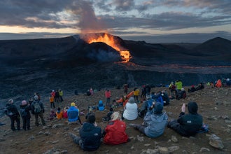
Aujourd'hui, vous pouvez débuter la journée avec la visite de l'intérieur d'un volcan. Ensuite, vous visitez le Cercle d'Or en Islande : route touristique constituée de la cascade Gullfoss, le parc national Thingvellir et Geysir.
Vous débutez avec le parc Thingvellir, lieu de naissance du premier parlement fondé en 930 et haut lieu géologique. Vous visitez ensuite Geysir situé dans la vallée de Haukadalur. Ce site est riche en bains de boue bouillonnants, fumerolles, ainsi que le geyser Strokkur, qui entre en éruption toutes les 8-10 minutes, propulsant de l'eau à plus de 40 m de haut.
Le dernier lieu de la journée est la cascade de Gullfoss. Son nom signifie justement « La Chute d'Or » . Nuit dans la région.
Exemple d'hébergement vers le Cercle d'Or
Cercle d'Or en super économique
Héraðsskólinn Boutique Hostel est idéalement situé au village Laugarvatn. L'auberge offre des lits en dortoir avec salles de bain partagées. Wifi gratuit. Petit déjeuner non inclus.
Cercle d'Or en économique
Héraðsskólinn Boutique Hostel est idéalement situé au village Laugarvatn. L'auberge offre des chambres avec salles de bain privées ou partagées. Wifi gratuit. Petit déjeuner non inclus.
Jour 3 - Côte sud entre cascades et plage volcanique
Aujourd'hui, vous prenez la route du sud de l'Islande. Depuis la route, vous pouvez apercevoir Eyjafjallajokull, le volcan dont l'éruption en 2010 a fait la une des journaux.
Lors de cette journée, vous visitez les cascades de Seljalandsfoss et de Skogafoss. Vous pouvez également visiter le musée de Skogar sur l'histoire du pays.
Vous découvrez ensuite la plage de Reynisfjara, avec une halte à Vik. Reynisfjara est l'une des plages les plus spectaculaires d'Islande avec son mur de basalte et son sable noir volcanique. Route et nuit dans le village tranquille de Kirkjubæjarklaustur.
Exemple d'hébergement vers Kirkjubæjarklaustur
Kirkjubæjarklaustur en super économique
Vagnstaðir Hostel est située à quelques pas de la plage et offre une belle vue sur l'océan et les montagnes environnantes. L'auberge offre des lits en dortoir avec salles de bain partagées. Wifi gratuit. Petit déjeuner non inclus.
Jour 4 - La région du Vatnajokull
Vous continuez votre voyage vers le Sud-Est de l'île vers la région du Vatnajokull. En chemin, découvrez la réserve naturelle de Skaftafell, offrant de nombreux sentiers de randonnée dont la randonnée vous menant à la cascade Svartifoss et ses colonnes de basalte. Vous avez également la possibilité de rejoindre une randonnée sur glacier guidée.
Vous reprenez ensuite la route vers Jokulsarlon : une lagune remplie de blocs de glace dérivant lentement vers l'océan. Vous pouvez partir en bateau naviguer parmi ses icebergs. Nuit à Kirkjubaejarklaustur.
Jour 5 - Retour à l'Ouest de l'Islande
Vous reprenez doucement votre route vers l'Ouest de l'île. En cours de route, vous pouvez visiter d'autres sites dont l'avion DC-3 ou la source chaude Seljavallalaug.
Dans l'après-midi, vous visitez la péninsule de Reykjanes avant de vous rendre au Blue Lagoon. Une baignade dans les eaux chaudes turquoises est idéale après un road trip en islande. N'oubliez simplement pas de réserver vos entrées en avance sur leur site internet. Nuit à Reykjavik.
Exemple d'hébergement vers Reykjavík
Reykjavík en super économique
Chambres ou lits en dortoir avec salles de bain partagées en guesthouses ou auberges de jeunesse comme HI Hostel. Hébergement situé dans la région de Reykjavik. Accès à une cuisine commune. Petit déjeuner non inclus.
Jour 6 - Fin de voyage
Aujourd'hui, vous déposez votre voiture à l'aéroport avant de prendre votre vol international.
Si votre vol est dans l'après-midi ou en soirée, profitez-en pour visiter un peu plus la capitale islandaise.
A bientôt en Islande !
Hébergement
Ci-dessous, découvrez nos catégories d'hébergement et des exemples d'hébergement par jour et par localité. En catégorie Super économique, vous occupez un lit en dortoir. Pour les autres catégories, un voyageur seul est en chambre individuelle. Un groupe pair loge en chambre double/twin et un groupe impair a des chambres triples et doubles. Si vous souhaitez une chambre supplémentaire, des frais peuvent s'appliquer. Les enfants et adolescents logent avec leurs parents.
Guide to Iceland sélectionne les meilleurs hôtels et chambres d'hôte disponibles au moment la réservation de votre voyage. Si les hébergements donnés à titre d'exemple ne sont pas disponibles pour vos dates, vous obtiendrez un hébergement de catégorie similaire. Nous faisons toujours notre possible pour répondre à vos demandes particulières qui peuvent dans certains cas entraîner des coûts supplémentaires. Choisissez une date pour voir les disponibilités.
Super Economique
Chambres ou lits en dortoir avec salles de bain partagées en guesthouses ou auberges de jeunesse situées dans la région des sites touristiques. Petit déjeuner non inclus.
Voiture
Ci-dessous découvrez les options de voitures de location pour votre autotour. Tous nos véhicules sont des modèles récents ou des modèles actuels. Les voitures super économiques ont 5 ans d'ancienneté maximum et sont équipées d'un GPS et de l'assurance CDW. Les autres catégories de voitures : voiture économique et 4x4 confort sont équipées d'un GPS et des assurances CDW, SCDW et la protection gravier. Surclassement possible en véhicule avec boîte automatique.
Super Economique
Une petite voiture 2 roues motrices idéale pour les voyages sur les routes principales comme une Toyota Aygo, Hyundai i10 ou similaire. Voiture confortable pour 2 voyageurs avec de petits bagages. Ce véhicule n'est pas apte à aller dans les Hautes Terres.
Economique
Une petite voiture 2 roues motrices idéale pour les voyages sur les routes principales comme une VW Polo, Toyota Yaris ou similaire. Voiture confortable pour 3 voyageurs avec de petits bagages. Ce véhicule n'est pas apte à aller dans les Hautes Terres.
Repas
Choisissez d'inclure vos repas du soir en option, et nous vous fournirons des bons à échanger dans des restaurants à Reykjavik et chacune de vos étapes. Nous choisissons parmi les restaurants les mieux notés qui correspondent à l'itinéraire de vos vacances. Au restaurant, plusieurs menus entrée-plat vous sont proposés, parmi lequel vous pouvez choisir des options standards avec poisson ou viande, ou bien les options végétariennes. Si vous préférez quelque chose à la carte, le coupon vaut également un certain montant. Les coupons ne sont pas remboursables.
Assurance annulation voyage
Cette assurance garantie l'annulation et le remboursement de l'ensemble de votre voyage sauf le prix de la souscription à l'assurance annulation voyage. Le coût de l'assurance annulation dépend de la durée de votre voyage ou de votre forfait. Un coût de base de 5 000 ISK par personne est appliqué à tous les séjours et forfaits d'une durée de 5 jours ou moins. Un montant supplémentaire de 1 000 ISK par personne sera ajouté au coût de l'assurance pour chaque jour suivant.
L'annulation peut être demandée jusqu'à 48h avant le début de votre voyage. Pour annuler votre voyage et demander un remboursement, merci d'envoyer un email à info@guidetoiceland.is jusqu'à 48h avant votre arrivée. Vous n'avez pas à donner de motifs ou bien à fournir de justificatifs.
Merci de noter que l'assurance couvre uniquement l'annulation complète de votre voyage. Elle ne couvre pas l'annulation de prestations de voyage individuelles, partie de votre voyage ou annulation d'un ou plusieurs participants. Le montant de l'assurance n'est ni remboursable ni transférable.
Carte
Vidéo
Consultez les avis
Il n'y a pas encore d'avis dans cette langue / pour cette note.,