Lo más destacado: South Iceland is the most popular part of the country and contains some of the most beautiful natural attractions in Iceland, among them the Golden Circle, some of Iceland's most famous active volcanoes as well as the beautiful Jokulsarlon glacier lagoon.
Geography
South Iceland is usually divided into the fertile South Icelandic lowlands between Hellisheidi and Eyjafjallajokull volcano on the one hand - and on the other hand the eastern part with the big volcanic glaciers Eyjafjallajokull and Myrdalsjokull (home of Katla) and flattened sands stretching towards the sea.
The South Icelandic lowlands
The South Icelandic Lowlands stretch nearly 100 km from Hellisheidi in the west towards Eyjafjallajokull in the east as a very flat and fertile farming land. From the shore the lowland stretches about km towards the inland. This is the best agriculture area in Iceland. The whole area is geologically very young, mainly of tuff type, formed during the Ice Age by the lava flows of the numerous volcanoes of the area. The area is indeed surrounded by volcanically active mountains on all sides. The glacier rivers of the area have helped filling the lavas with sand and clay, leaving it more and less smooth and fertile. Very strong earthquakes are found in this area as well.
The most active volcanoes of the area are Hekla and Eyjafjallajokull. No less active and not far off, but on the east side, is Katla, which we’ll adress in the eastern part-section. South of the mainland are the volcanic Westman Islands, famous for the 1973 eruption as well as the eruption in 1963, when Surtsey island was formed. Closely linked to the volcanic activity in the south is the geothermal heat found in many places, the best known being the Geysir area, which forms a part of the famed Golden Circle, which also consists of Gullfoss waterfall , Iceland's most famous waterfall as well as one of its most beautiful, located in the popular rafting river Hvita and Thingvellir National Park, comprising three of Iceland's most beloved natural attractions.
The earthquakes of the area bear witness to the fact that Iceland is still in shape. This is further evidenced by the endless number of fissures in the lavas, fractures in the mountains and certain pieces of lands sinking. The area of Thingvellir is the best known example of this, showcasing the continental drift. Thingvellir is a UNESCO World Heritage Site and the location of the old parliament, Althingi, (now situated in Reykjavik) and one of Iceland's most important sites.
Another of Iceland's most popular attractions is the beautiful Thorsmork valley, situated between Myrdalsjokull and Eyjafjallajokull.
Natural harbour-sites are hardly any on the South shore, due to sand produced by the glacier rivers. A few towns are found in the area, Selfoss being the biggest one, Hveragerdi is another, then there are Hella and Hvolsvollur, all conveniently located by the ring road. By the shore are three fishing villages; Thorlakshofn, Eyrarbakki and Stokkseyri. Thorlakshofn the only one of those that can accommodate modern ships and ferrys. The ferry to the Westman Islands sails from there. A new harbour has been built on the sandy coast opposite the Westman Islands. The whole south shoreline offers some of the most gigantic braker waves that you are likely to see.
Culturewise, in addition to Thingvellir, we reccomend the ancient bishop seat of Skalholt (weekends at Skalholt further offer rich music life). Also, Iceland's most famous saga, Njal's saga takes place in the South lowlands. We further recommend the large reconstructed turfhouse near Stong and the ancient excavated ruins.
For sports, horse riding is popular in the area as well as catching salmon or trout, hiking, and river rafting in Hvita.
The east part of South Iceland.
This is the area south and east of Myrdalsjokull. The volcanic glaciers Eyjafjallajokull (near the border of the eastern and western part) and Myrdalsjokull, dominate the view. The landscape has been shaped by volcanic eruptions and vast sands stretch to the sea. Some agriculture is found here, however, with the farms in a row alongside the mountains. A few large glacial rivers fall down in this area which also has striking waterfalls, such as Skogafoss and Seljalandsfoss.
Eyjafjallajokull is already well known for its 2010 eruption, disturbing air communication all over Europe for many days. Much more serious,however, would be an eruption from Katla, a volcano in the eastern part og Myrdalsjokull.
Katla’s last eruption was in the year 1918, when an enormous flood of water exploded from the glacier in a matter of minutes, threatening the local farmers of the area. Large amounts of ash and muddy material were brought to sea to form a new land of sand, Kotlutangi, later washed away by the sea. No people were killed in this eruption. Eruptions in Katla throughout the ages have further created the vast sand area Myrdalssandur. Sixteen eruptions have been recorded for Katla since 930 at intervals of 13-95 years and the volcano is being closely monitored, as time may draw near to its next eruption.
In the same volcanic system as Katla (geologically speaking), are the Lakagigar craters, northeast of Myrdalsjokull. Those erupted in the years 1783-84; producing the largest amount of lava known in historic times. The ashes hindered the sunlight from reaching down to the surface of Earth, resulting in cold climate over northern Europe.
In this area – what we call the eastern part of South Iceland -, there are many places worth visiting: Solheimajokull is a beautiful glacier in a walking distance (an outlet of Myrdalsjokull); Skogar has a very interesting museum of older time traditions and Skogafoss is only a few km away from there. One of Iceland’s most famous hiking routes, Fimmvorduhals, starts from Skogar. Southwest of the village Vik is one of Iceland’s most spectacular beaches, Reynisfjara. Together with the promontory Dyrholaey, which is the southernmost tip of the mainland of Iceland, it offers a breathtaking view with amazing rock formations, a black pebble beach, an abundance of birds and the powerful waves of the North Atlantic Ocean crashing on the beach.
Further east stretches the world's most vast sand plain, Skeidararsandur. North of the sand is the fascinating Skaftafell preservation area. At its east end, south of Hvannadalshnukur, Iceland's highest peak, is Ingolfshofdi cape, with its rich birdlife, old fishermen's shacks and its lighthouse. Following the shore further east is the incredibly beautiful and ice-filled Jokulsarlon glacier lagoon. Not far off is the region of Sudursveit, featuring the culture center and heritage museum Thorbergssetur, erected in the memory of Icelandic author Thorbergur Thordarson.
Sur de Islandia, 
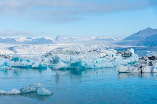
Jökulsárlón is Iceland’s most famous glacier lagoon. Conveniently located in the southeast by Route 1, about halfway between the Skaftafell Nature Reserve and Höfn, it is a popular stop for those travelling along the South Coast or around the circular ring road of the country.
Geography
As a glacier lagoon, Jökulsárlón is a lake that is filled with the meltwater from an outlet glacier. In this case, it is Breiðamerkurjökull, a tongue of Europe’s largest ice cap, Vatnajökull.
It stands out, however, due to the fact that it also fills with icebergs breaking from the glacier, some of which tower several stories high.
These icebergs, other than their scale, are notable for their colouration. Although they are, as expected, largely white, most are also dyed electric blue in part, with black streaks of ash from eruptions centuries past.
When the icebergs finally make it across the lagoon, they either drift out to sea or wash up on the nearby shore. Because of the way they glisten against the black sands of Breiðamerkursandur, this area has been nicknamed ‘the Diamond Beach’.
In spite of being a rather recent formation, Jökulsárlón is the deepest lake in the country, with depths reaching 248 metres. With a surface area of 18 square kilometres, it is also growing to be one of the largest.
History
Jökulsárlón has not been around since Iceland’s settlement; it only formed around 1935. This was due to rapidly rising temperatures in the country from the turn of the twentieth century; since 1920, Breiðamerkurjökull has been shrinking at a dramatic rate, and the lagoon has begun to fill its space.
Today, the expansion of Jökulsárlón is accelerating. As recently as 1975, it was just 8 square kilometres, and now that size has more than doubled.
In the relatively near future, it is expected that the lagoon will continue to grow until it becomes a large, deep fjord.
Though a dark omen for Iceland’s glaciers and ice caps in general, the retreat of Breiðamerkurjökull has resulted in an incredibly beautiful, if temporary, site. This has not been overlooked by Hollywood.
Jökulsárlón has been featured in the James Bond films A View to Kill in 1985 and Die Another Day in 2002, 2001’s Lara Croft: Tomb Raider, and 2005’s Batman Begins.
In 2017, Jökulsárlón was enveloped into the Vatnajökull National Park, thus it is now fully protected by Icelandic law.
Wildlife
Because of the wealth of herring and capelin that the tides bring into the lagoon, Jökulsárlón is somewhat of a hot-spot for Iceland’s wildlife.
In summer, it is a nesting site for Arctic Terns; stay well away from this area, as these birds are notorious for the fierceness with which they protect their eggs, dive-bombing the heads of any they see as a threat. Skuas also nest on the lake’s shores in this season.
Seals can be reliably spotted here throughout the year, swimming amongst or else hauling out on the icebergs. Jökulsárlón provides them with a safe haven to rest and socialise, especially considering the waters of southeast Iceland are renowned for their population of orcas.
Jökulsárlón, 
Vatnajökull glacier is the largest ice cap in Iceland and the third largest glacier in Europe, covering 8% of the island's landmass. Vatnajökull National park can be found in the south west of Iceland and is a popular spot for activities like glacier hiking from Skaftafell, boat tours and ice caving tours from Jökulsárlón glacier lagoon, both of which are part of Vatnajökull national park.
Facts about Vatnajökull
- Surface: 8,100 km2
- Average thickness: 400 - 600 m
- Maximum thickness: 1,000 m
- Height: 1,400 - 1,800 m
- Highest peak: 2,200 m (Hvannadalshnjúkur)
Information about Vatnajökull
Vatnajökull Glacier belongs to the greater Vatnajökull National Park, which encompasses the former national parks Skaftafell, in the southwest, and Jökulsárgljúfur, in the north. Vatnajökull's highest summit is Hvannadalshnjúkur which rests on top of a stratovolcano known as Öræfajökull.
Underneath the glacier rests some of the most active volcanoes in the country, the most notable being Grímsvötn, Öræfajökull and Bárðabunga. Volcanic activity in the region has occurred on and off throughout the centuries, and many geologists believe that such a period is overdue for immediate future. If their calculations are correct, it would mean significant volcanic activity for Vatnajökull over the scope of the next half century.
The glacier boasts of over 30 outlet glaciers, which are channels of ice that flow out of ice caps but remain constrained on the sides of the valley. The major outlet glaciers of Vatnajökull include Dyngjujökull in the north, Breiðamerkurjökull and Skeiðarárjökull to the south. To the west, one can find the outlet glaciers Síðujökull, Skaftárjökull and Tungnaárjökull.
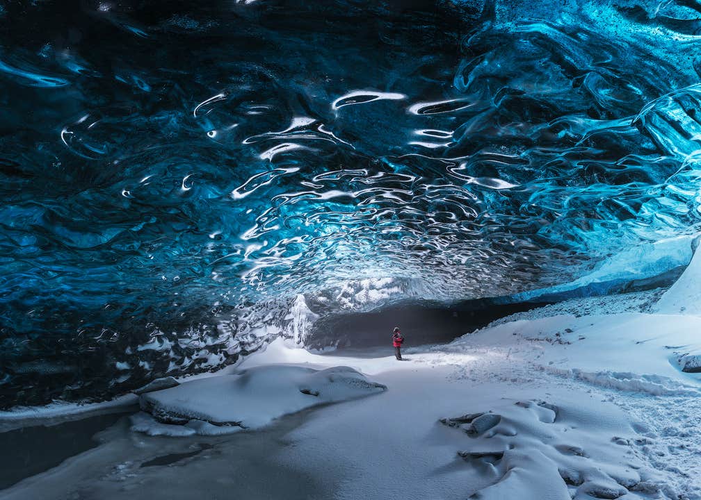
Glaciers are in constant motion underneath their weight; as they form over the centuries, the accession of snow exceeds its melting, creating a constant "push" on the ice cap. Each year, due to the melting ice water, new ice caves form that disappear come spring.
Numerous rivers run out of Vatnajökull, making up some of the greatest glacial rivers in Iceland:
- Tungnaá (west)
- Köldukvísl (west)
- Þjórsá (west)
- Jökulsá á Fjöllum (north)
- Skjálfandafljót (north)
- Jökulsá á Brú (north east)
- Jökulsá í Fljótsdal (north east)
- Jökulsá í Lóni (south)
- Hornafjarðarfljót (south)
- Jökulsá á Breiðamerkursandi (south)
- Skeiðará (south)
- Núpsvötn (south)
- Hverfisfljót (south)
- Skaftá (south)
Vatnajökull National Park
Vatnajökull National Park, in its current state, was established in June 2008. The park now covers an area of 14.141 km2, making it the second largest national park in Europe. Vatnajökull National Park has 14% coverage over the whole island of Iceland.
Rivers divide the highland plateau to the north of the park; an area that sees massive glacial flows in the summertime. The volcanic table mountain Herðubreið towers over this particular region, along with volcanoes Askja, Snæfell and Kverkfjöll.
The canyon Jökulsárgljúfur was carved out by glacial floods centuries ago. At the upper end of the canyon, you'll find Dettifoss, the most powerful waterfall in Europe. Further north, the horseshoe-shaped canyon Ásbyrgi is believed to have formed when Óðinn's horse, Sleipnir, stepped his foot down from the heavens.
East around Snæfell, one can find wetlands and ranges, home to roaming herds of wild reindeer and abundant birdlife. Steep mountain ridges make up the south side of Vatnajökull, where outlet glaciers crawl in between the ridges onto the lowlands. The sandy plains of Skeiðarársandur also lie to the south as they reach out to sea. The glacial river Skeiðará runs through this vast desert.
One of Iceland's most visited landmarks is the Jökulsárlón glacier lagoon, which sits at the head of outlet glacier Breiðamerkurjökull. There, large icebergs that have broken off the glacier gather to float in the lake before ending up in the Atlantic Ocean, or on the nearby Diamond Beach.
The Future of Vatnajökull
The volume of Vatnajökull reached its peak around 1930 but has since been in a steady process of decline. Because of rising levels of global temperature, approximately over the last 15 years, Vatnajökull has on average lost about a metre of its thickness annually.
If temperature levels continue to rise, the glacier could be all but gone nearing the end of the next century, leaving only small ice caps on top of the highest mountain summits.
Vatnajökull and Jökulsárlón in Popular Culture
- HBO's Game of Thrones (season 2, 2012)
- Batman Begins (2005)
- James Bond: Die Another Day (2002)
- James Bond: A View to a Kill (1985)
Vatnajökull, 
Skógafoss is one of the country’s biggest and most beautiful waterfalls with an astounding width of 25 meters (82 ft) and a drop of 60 meters (197 ft). Due to the amount of spray the cascade produces, a rainbow is present any time the sun emerges from behind the clouds.
Located on the Skógá river, this mighty cascade is clearly visible from Route 1 and is an excellent place to stop and stretch the legs while travelling Iceland’s South Coast. The river below Skógafoss holds a large char and salmon population and is thus a favourite spot for fishermen in the summer.
The land underneath the waterfall is very flat, allowing visitors to walk right up to the wall of water. Keep in mind, however, that this will get you drenched. Skógafoss can also be viewed from the top as a steep staircase leads to an observational platform above the cascade.
Geography
Skógafoss is located near the small village of Skógar, south of the Eyjafjallajökull glacier volcano. There you’ll find the Skógasafn folk museum, an open-air museum with both old wooden houses and turf houses, as well as a regional museum with various artefacts from this area.
A part of the Skógasafn Regional Museum is the Museum of Transportation, which showcases the history and evolution of transportation, communication and technologies in Iceland. There, you can see how this nation evolved from the age of the working horse to the digital communications of the 21st century.
The Skógasafn museum also includes a café and a museum shop, and in the village of Skógar, you will find both a hotel and a restaurant.
At the eastern side of Skógafoss, you will find one of Iceland’s most famed hiking routes; the Fimmvörðuháls pass. The 22 km (14 mi) trail takes you along Skógá river, between two glaciers, Mýrdalsjökull and Eyjafjallajökull, before ending in the beautiful Þórsmörk valley.
Folklore
A gold ring is on display at the Skógasafn museum. According to legend, the ring is from a chest that was owned by Þrasi Þórólfsson, one of the first Viking settlers in the area. Folklore states that before his death in 900 AD, Þrasi buried a chest filled with gold in a cave behind Skógafoss waterfall.
Many attempts were made to retrieve the chest after Þrasi’s death, and years later, locals managed to grasp a ring on the side of the chest. As they pulled, the ring broke off, and the treasure was lost forever. The ring was then given to the local church before it made its way to the museum.
Skógafoss, 
Seljalandsfoss is a waterfall, situated on the South Coast of Iceland, with a drop of 60 metres (200 feet).
Due to the waterfall’s close proximity to the Ring Road and impressive natural features, it is one of the most famous and visited falls in the whole country. Majestic and picturesque, the waterfall is one of the most photographed features in the whole of Iceland.
Geology and Surroundings
Seljalandsfoss waterfall, part of the river Seljalandsá, has its origins underneath the glacier volcano Eyjafjallajökull. The cascade of the falls is relatively narrow. However, it used to be wider until a flood in 1976 altered the shape of the cliffs from which the waterfall tumbles. The rainfall during the day of the flood measured 101 millimetres (4 inches), which caused a significant rise in the water levels of rivers in the area. This event caused a new crack to form in the cliffs, that subsequently redirected the width of the falls.
The cliffs themselves are the remnants of a former coastline, which now separates the lowlands from the Highlands of Iceland. The same can be said of Seljalandsfoss’s equally famous neighbour, Skógafoss waterfall.

The most distinguished feature of Seljalandsfoss is a natural pathway that stretches all the way around it. The cliffs behind the falls, therefore, form an accessible cave. Visitors can easily walk this path, although they should be prepared to get dampened due to the perpetual mist of the falls, which also tends to make the rocks of the pathway slippery. During the winter season, it is highly advised not to walk around the falls since the icing makes the walk too hazardous.
However, floodlights have been set up on both sides of the waterfall, which impressively illuminate the scene during dark winter nights. The lights were installed in 2001 due to the growing popularity of the falls as a tourist destination.
After visiting Seljalandsfoss, it is common for visitors to continue north to the waterfall Gljúfrabúi, which is found partially hidden behind a rock face. Because of Seljalandsfoss extreme popularity, Gljúfrabúi is widely considered an additional hidden gem of the scene.
Visitor Centre Controversy
In 2017, it was announced that a visitor’s centre was to be constructed near the falls. The design of the building indicates that it would be 7 metres (23 feet) high and 2,000 square metres (21,500 square feet) in size. Landowners in the area opposed to the idea, proclaiming that the centre would greatly alter the natural appearance of the waterfall’s renowned scenery.
The project has neither been fully approved nor wholly cancelled, with ideas surfacing of either significantly reducing the size of the construction, or moving the visitor centre’s location further away, for instance to the nearby farmstead Brekkuhorn.
Seljalandsfoss in Popular Culture
Along with a multitude of South Iceland’s most famous natural attractions, Seljalandsfoss can be seen in Justin Bieber’s music video for his song ‘I’ll Show You’.
The waterfall was also a featured waypoint during the first leg of the sixth season of The Amazing Race, an American reality TV series.
Seljalandsfoss,
The glacier volcano of Eyjafjallajokull (1651 m) is located at the borders of the South Icelandic highlands. It featured prominently in world news in 2010 when ash from its eruption halted air traffic in Europe.
An ice cap of about 100 km with several outlet glaciers covers the caldera of Eyjafjallajökull that stands at the height of 1651 meters. The diamaeter of its highest crater is around 3-4 km2 wide and the rim has several peaks.
Eyjafjallajokull glacier volcano lies north of Skogar, and to the west of Myrdalsjokull glacier and the massive volcano there; Katla.
Eyjafjallajokull is thought to be related geologically to Katla in Myrdalsjokull and eruptions in the former have often been followed by eruptions in the latter.
The 2010 eruptions
The end of 2010 saw some small seismic activity that gradually increased and resulted in a small eruption in March of 2010, characterized by a flow of alkani-olivine basalt lava.
This first stage lasted until April 12th and created the volcanic craters Magni and Modi at the Fimmvorduhals trail. They are so far Iceland's newest vocanic craters, and still eminate steam with lava glowing under the surface.
However it was the second phase of the eruption that started on April 14th that created the huge ash cloud that rose about 9 km into the skies.
This eruption halted air traffic in Europe for days, and its estimated that as many as 107.000 flights may have been cancelled during the week it lasted.
The ejected tephra measured around 250 million cubic meters. This ash cloud lasted for six days and some more localized disruption continued into May. The eruption was officially declared to be over in October 2010, as the snow on the glacier had ceased to melt.
Future volcanic developments?
Eyjafjallajokull erupted in years 920, 1612 and again 1821-1823.
Its latest eruptions were the two that occurred in 2010.
Future volcanic developments remain unclear. The area is still highly active and can be quite unpredictable. It continues, however, to be closely monitored by The Icelandic Meterological Office.
Eyjafjallajökull, Katla is an active volcano situated under the glacier Myrdalsjokull in South Iceland. It is one of Iceland's most well known volcanoes.
Katla's eruptions have produced many massive glacier bursts, with enormous amounts of water flowing, as the fire melts the ice. Its latest eruption was 1918. That eruption created the spit Kötlutangi, which is the mainland's southernmost tip.
Katla, Solheimajokull is a beautiful outlet glacier of the Myrdalsjokull icecap.
Solheimajokull is a rugged glacial tounge riddled with crevasses and spectacular ever-changing ice formations, jagged ridges and sinkholes and is popular for hiking and ice climbing.
The glacier river Jokulsa a Solheimasandur has its source at the glacier, flowing over the sand plain of Solheimasandur towards the sea.
Sólheimajökull, 
Mýrdalsjökull is a glacier in the south of the Icelandic highlands. It is the country's fourth largest ice cap, covering nearly 600 kilometres squared, and its highest peak is almost 1500 meters tall. It is most well-known for sitting atop the notorious and explosive volcano, Katla.Mýrdalsjökull is visible from Route 1 on the South Coast, sitting to the north of the village of Vík.
Eruptions beneath Mýrdalsjökull
Since 2010, the world has known of the volcano beneath Eyjafjallajökull; few, however, are aware of the much larger volcano right beside it. Mýdalsjökull conceals Katla, one of the country’s most active volcanoes, having erupted, on average, once every fifty years since 930 AD. Because of the glacier above it, these eruptions tend to cause enormous ash clouds.
The last major eruption beneath Katla was in 1918, in which such huge lahar floods occurred that the southern coastline was extended five kilometres outwards. This area is also very susceptible to glacial floods, or jökulhlaups, during eruptions, even when the lava does not break through the surface of the ice.
Historically, the area was little settled for this reason.
Katla is connected to the same volcanic system as Eyjafallajökull and usually erupts violently a few years after. As the ex-president, Ólafur Ragnar Grímsson said in 2010:
‘The time for Katla to erupt is coming close… it is high time for European governments and airline authorities all over Europe and the world to start planning for the eventual Katla eruption’
Katla is monitored heavily, and roads around it closed when seismic activity increases. All road closures around Iceland can be found on Road and Coastal Administration's website.
Tours on Mýrdalsjökull
While there are no eruptions immediately imminent, tours continue to run on Mýrdalsjökull, allowing visitors to enjoy the glacier. It is, for example, possible to snowmobile across its surface throughout the year and take ice caving tours beneath it from October to April, with departures from both Reykjavík and Vík.
Considering the ice caves under Vatnajökull glacier are usually only accessible from November to March, this provides a wider window of opportunity for travellers to Iceland outside of the depths of winter. It should be noted that the caves in Mýrdalsjökull do not have the same blue ice, however.
Tours around Mýrdalsjökull
Mýrdalsjökull can be seen on all South Coast tours that reach Vík and beyond in clear weather. It can also be seen from above on helicopter tours that depart from Reykjavík.
The best perspectives of the glacier, however, can be found on the popular Fimmvörðuháls hiking trail, which goes between Eyjafjallajökull and Mýrdalsjökull. Part of this hike can be done in a day, or you can take the complete route from Þórsmörk to Skógar on a three-day trek.
Mýrdalsjökull,
Photo from Tour to Skaftafell from Reykjavik.
Skaftafell Nature Preserve can be found in Öræfasveit, the western region of Austur-Skaftafellssýsla in Iceland. Skaftafell once used to be a national park in its own right but was merged with the far larger Vatnajökull National Park in 2008.
Skaftafell is notable for its rich flora, growing between sands and glaciers, and for its amazing and contrasting scenery. At Skaftafell, visitors will find a wealth of natural attractions, from cascading waterfalls to panoramic views over this picturesque region.
Like many areas along the South Coast of Iceland, Skaftafell Nature Preserve is known for its glorious hiking trails. You can take short and easy treks to the waterfalls Svartifoss and Hundafoss, as well as to the gorgeous Skaftafell glacier. A little further along, guests will stumble on the mountain, Kristinartindar, as well as the scenic Morsardalur Valley.
Skaftafell is also the perfect base camp for those seeking to climb Iceland’s highest peak, Hvannadalshnúkur, or for those wishing to spend a number of days exploring the region's attractions, including Vatnajökull glacier, Jökulsárlón glacial lagoon and the nearby Diamond Beach. It is also an excellent region to try your hand at a spot of either ice climbing or glacier hiking; both activities are two of the most authentically Icelandic experiences you can partake in whilst in the country.
Skaftafell Visitor Center
Skaftafell also boasts a Visitors Centre, acting as the main information and meeting point for tour operators and independent travellers. At the Skaftafell Visitor Centre, you will find answers to virtually any questions you might have about the greater Skaftafell area, including its history and geology. The Visitors Centre also contains information about nearby hiking trails, recreational options and accommodation.
Skaftafell, Hofn a Hornafirdi, is a fishing town in southeast Iceland, with a population of 1641 (as of 2011). It has a strong harbour and its main industries are fishing and tourism.
Of note are several interesting museums and the annual Humarhatid (lobster festival). The area is also rich and varied birdlife and migratory birds from Scotland land here around April and leave around August/September.
Höfn, 
Reynisfjara is a world-famous black-sand beach found on the South Coast of Iceland, just beside the small fishing village of Vík í Mýrdal.
With its enormous basalt stacks, roaring Atlantic waves and stunning panoramas, Reynisfjara is widely considered to be the most beautiful example of Iceland’s black sand beaches. In 1991, National Geographic voted Reynisfjara as one of the Top 10 non-tropical beaches to visit on the planet.
Reynisfjara is found around 180 km from Iceland’s capital city, Reykjavik, and is a popular stop-off for those taking a sightseeing tour along South Coast. Driving to the beach is particularly easy, taking an approximate two and a half hours from the capital.
Folklore
Upon visiting the beach, travellers will immediately observe rocky sea stacks sitting off the shoreline, known as Reynisdrangar. According to local Icelandic folklore, these large basalt columns were once trolls engaged in trying to pull ships from the ocean. However, as bad luck would have it, the dawn quickly arose, turning the trolls into solid stone.
Another legend tells of a husband whose wife was kidnapped and killed by two trolls. The man followed the trolls down to Reynisfjara where he froze them, ensuring that they would never kill again.
The sea stacks themselves are home to thousands of nesting seabirds. Species that can be found here include Puffins, Fulmars and Guillemots, making it a must-see location for all birdwatchers out there.
Potential Dangers
Visitors to Reynisfjara must be made well aware of the potential dangers present at the beach. First of all, the rolling, roaring waves of Reynisfjara are particularly violent, often pushing far further up the beach than many would expect.
Visitors are advised to never turn their back on the waves, don't go chasing after them and keep a safe distance of 20-30 metres.
Aside from these sudden and dramatic shifts in tide (known as “sneaker waves”), the currents off the shore are infamous for their strength and ability to drag helpless people out into the freezing cold open ocean. A number of fatal accidents have occurred at Reynisfjara, the last of which occurred in January 2017.
Reynisfjara Black Sand Beach, Vik in Myrdalur valley is the southernmost village on the Icelandic mainland, located 186 km from the capital Reykjavik.
Vik is important as a service centre for the inhabitants and visitors of the marvellous Reynisfjara beach.
Reynisfjara is widely considered one of the most beautiful beaches on earth (see for example Islands Magazine). This black pebble beach boasts an amazing cliff of regular basalt columns called Gardar, which resembles a rocky step pyramid and out in the sea are the spectaculary shaped basalt sea stacks Reynisdrangar. The area has rich birdlife, including puffins, fulmars and guillemots.
Vík í Mýrdal, 
Reynisdrangar are rock formations situated near the shore of Reynisfjara beach by the coastal village Vík í Mýrdalur on the South Coast of Iceland.
The formations are large and impending sea cliffs, made up of the rock type basalt, that serve as a vital part of the area’s allure as they shoot dramatically out of the ocean under the looming cliffs of Mt. Reynisfjall.
Dangerous Waves
The village of Vík only houses around 300 permanent inhabitants, but on a daily basis, travellers scouting the South Coast make their way there to visit what has been voted as one of the most beautiful non-tropical beaches in the world. The beach of Reynisfjara, however, can be highly dangerous if proper caution is not taken. As is evident from how the waves of the Atlantic Ocean crash upon Reynisdrangar, the currents here are strong, and sneak waves can easily carry anyone that’s standing too close out to sea. The beach is not for wading, but for admiring, and especially the mighty surf bursting on the base of these rocky cliffs.
Folklore
There is an Icelandic folk tale that explains the origin of the pillars’ eerie appearance. According to legend, a couple of trolls were busy dragging a stranded three-masted ship to shore when the sunlight hit them and turned them into pillars of rock for all eternity. In fact, numerous rock formations in Iceland carry with them tales of trolls or elves, and one has only to look at them to fathom why.
Surroundings & Wildlife
An alternative view of the bewitching cliffs and their surrounding sea can be enjoyed by venturing up Mt. Reynisfjall, by a road to the west of the village. The mountain furthermore functions as a puffin colony every summer, from April to September, meaning guests can enjoy the view in good company. Other birds can be seen gliding around the cliffs such as Arctic terns, fulmars and seagulls.
Reynisdrangar, 
The Capital Region refers to Reykjavík and its bordering towns. It holds well over half of the country’s population, in spite of taking up less than 1% of the country’s landmass.
The towns surrounding the capital are Kópavogur, Hafnafjörður, Garðabær, Mosfellsbær, Seltjarnarnes and Kjósarhreppur. Combined with Reykjavík city itself, these municipalities account for around 220,000 people.
Although each area is its own municipality, they cooperate on issues like transport, and by doing so, keep the region well connected.
Capital Region, Breiðamerkurjökull is the glacial tongue that extends from southern Vatnajökull and into the glacier lagoon Jökulsárlón.
Breiðamerkurjökull is constantly retreating, breaking and melting, causing the Jökulsárlón glacier lagoon to increase in size. This glacier tongue provides the lagoon with all of its enormous icebergs, which perpetually break from off its tip and tumble into the abyssal waters where they float for about 5 years until they are small enough to make their way towards sea and join the countless smaller ice chunks that adorn the nearby Diamond Beach.
Breiðamerkurjökull is beset with enormous cracks and crevices, and since it's virtually impossible to tell exactly when the next big block of ice will break from it, people should admire this enormous glacier tongue from a great distance.
Breiðamerkurjökull, 
The South Coast of Iceland is the country's most visited sightseeing route, along with the Golden Circle.
The famed South Coast shoreline stretches from the greater Reykjavík area and is dotted with natural wonders such as cascading waterfalls, volcanoes both active and dormant, black sand beaches and glacier lagoons.
Geography, Nature & Wildlife
Iceland is divided into eight geographical regions. Out of these, the Southern Region is the largest, as it spans over 24.000 square kilometres with its administrative centre in the municipality of Selfoss.
What is known as the South Coast embodies the shoreline of this particular region. The area consists of a lowland that is mostly composed of marshlands, bays and cultivated pastures that are met by a series of black beaches where the estuaries to the east and west of the district close off the coastal body.
Underneath the soil rests a vast lava field, known as Þjórsárhraun. Its edges reach several hundred metres offshore where the ocean waves crash upon them, thereby protecting the lowland from the invasion of the sea. This results in the South Coast being unusually lacking in the deep fjords that so distinctly characterise the rest of Iceland's shore line.
The region boasts vibrant bird life during all seasons. It is not only rich with both marshland birds and seabirds but also migrating birds such as the North Atlantic puffin. Some species stay throughout the harsh Icelandic winter, including the northern diver, the loom and various species of gulls and ducks.
Highlights of the South Coast
The South Coast offers an unprecedented array of natural wonders that draw thousands of visitors each day. When driving the route from Reykjavík City, the highlights in their correct order are:
These attractions count for but a fraction of what the South Coast has to offer. The vast sand plains of Sólheimasandur are home to a crashed DC-3 Plane Wreck, and close to Seljavellir by the Skógar Village there's Seljavallalaug, one of the oldest swimming pools in Iceland.
Costa Sur, 
The Diamond Beach is the name of a strip of black sand belonging to the greater Breiðamerkursandur glacial plain, located by the Jökulsárlón glacier lagoon on the South Coast of Iceland.
Breiðamerkursandur
Breiðamerkursandur is a glacial outwash plain located in the municipality of Hornafjörður. The sand stretches approximately 18 kilometres along Iceland’s South Coast, more specifically from the foot of Kvíárjökull Glacier to the famed glacier lagoon Jökulsárlón, that nests by the foot of Breiðamerkurjökull Glacier. Both glaciers count amongst the 30 outlets of Vatnajökull, Iceland’s largest ice cap.
The outwash plain was formed when three of Vatnajökull’s outlet glaciers, Breiðamerkurjökull, Hrútárjökull and Fjallsjökull, flowed forward due to volcanic activity and ground the rocks of the underlying surface, creating and pushing forward the glacial sediments. Such sand plains are a common part of the Icelandic landscape, due to the island being volcanically active as well as boasting numerous ice caps. The terminus (the tip of a given glacier) also dug deep into the ground and left what is now the Jökulsárlón glacier lagoon.
Jökulsárlón Icebergs
The Jökulsárlón glacier lagoon is one of the most famed and visited attractions in Iceland. Floating on the lagoon are enumerable ice bergs that have broken off the resident glacier, creating an ever-changing scenery of incredible allure.
The river Jökulsá connects the lagoon to the Atlantic Ocean, meaning that these icebergs eventually drift out to sea where they are polished by the waves before floating back to the black sands of Breiðamerkursandur. The name "Diamond Beach" comes from the white ice on the black sand appearing like gemstones or diamonds, as they often glisten in the sun and sharply contrast their jet black surroundings.
Diamond Beach