


소개
요약
소개
아이슬란드 남부 해안(South Coast)을 이전과는 전혀 다른 방식으로 경험해 보세요. 이 2일간의 여름 모험으로 우뚝 솟은 폭포, 장엄한 빙하, 그리고 이 지역을 잊을 수 없게 만드는 매혹적인 검은 모래 해변을 탐험할 수 있습니다. 자연 애호가에게 완벽한 이 투어는 아이슬란드의 가장 특별한 풍경을 최전선에서 감상할 수 있는 기회를 제공합니다.
시작부터 끝까지 모든 세부 사항이 완벽하게 준비된 원활한 여정을 즐기세요. 계획은 저희가 책임지니, 아이슬란드의 숨막히는 풍경에 완전히 몰입하고 소중한 추억을 만드는 데만 집중하시면 됩니다!
편의를 위해 이 여름 투어에는 레이캬비크 픽업 및 복귀 서비스가 포함됩니다. Wi-Fi가 제공되는 미니버스로 편안하게 이동하고, 이 환상적인 여정을 함께할 전문 가이드도 있어 든든하지요.
이틀 동안 남부 해안의 필수 관광지를 모두 방문하며 숨겨진 보석 같은 명소들도 발견하게 됩니다. 셀야란드스포스(Seljalandsfoss), 글류프라부이(Gljufrabui), 스코가포스(Skogafoss) 등 장엄한 폭포들을 탐험하세요. 평화로운 협곡에 자리 잡은 숨겨진 크베르누포스 폭포도 만나보시고요.
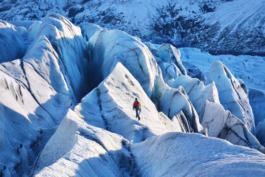
솔헤이마요쿨(Solheimajokull) 빙하에서는 아이젠과 얼음 도끼 등 제공되는 모든 안전 장비를 착용하고 가이드와 함께하는 빙하 산책을 즐기실 수 있습니다. 이날은 또한 레이니스피야라(Reynisfjara) 검은 모래 해변으로 이동하여 화산성 모래, 인상적인 현무암 기둥, 그리고 드라마틱한 암석 지형 위에 쉬고 있는 바다새들을 감상하실 수 있습니다.
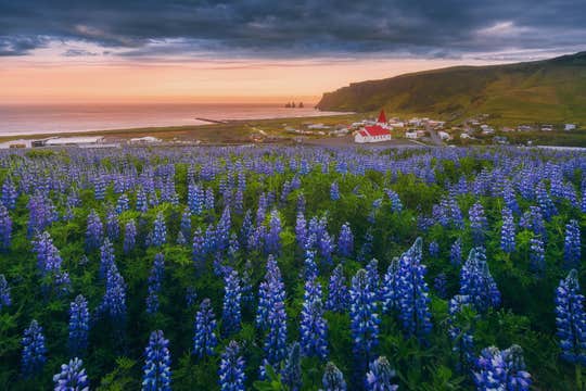
아름다운 비크(Vik) 마을을 지나며 경치 좋은 드라이브를 즐기고, 아름다운 포스 아 시두(Foss a Sidu) 폭포를 방문합니다. 여름철 백야 현상은 풍경을 더욱 경이롭게 만드는 동시에 아이슬란드의 경이로운 자연을 탐험할 시간을 더 많이 선사합니다.
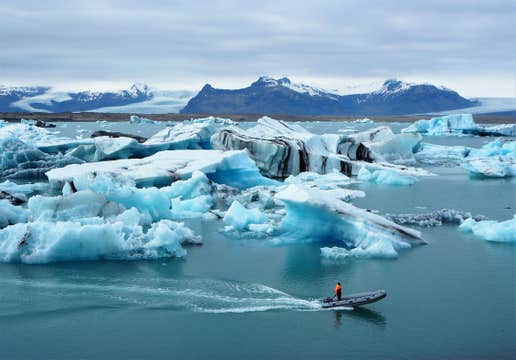
스카프타펠(Skaftafell) 자연 보호구역에서는 광활한 빙하와 함께 짧은 하이킹과 자연 속 평화로운 점심 식사에 완벽한 경관 트레일이 기다립니다. 이 모험은 아이슬란드의 보석인 요쿨살론(Jokulsarlon) 빙하호수와 눈부신 다이아몬드 해변(Diamond Beach)으로도 안내합니다.
저녁에 레이캬비크에 도착하며 투어가 마무리되며, 아이슬란드 남부 해안의 잊지 못할 추억을 선사합니다.
현지 전문가의 노하우로 설계된 이 투어는 시간과 비용을 절약하면서도 잊지 못할 경험을 보장합니다. 여행 중에는 편안함과 편리함을 동시에 제공하는 엄선된 숙소에서 머물며, 매일의 모험 후 휴식을 취할 수 있습니다.
지금 바로 예약하세요! 이 놀라운 2일간의 남부 해안 투어를 통해 아이슬란드의 폭포, 빙하, 검은 모래 해변의 마법을 경험하세요. 날짜를 선택하여 지금 바로 예약 가능 여부를 확인하세요.


