Najlepsze wycieczki quadami i buggy na Islandii
Wybierz lokalizację początkową
Wybierz daty
Dodaj podróżnych
Wycieczki quadami i buggy
Doprecyzuj wyniki za pomocą filtrów


Sprawdź naszą ofertę niesamowitych wycieczek i pakietów
Często zadawane pytania
Jaka jest najlepsza wycieczka quadem lub buggy na Islandii?
Popularną wycieczką quadem lub pojazdem buggy na Islandii jest ekscytująca przejażdżka quadem na południowym wybrzeżu do wraku samolotu DC, oceniona na 4,6 z 5 gwiazdek przez ponad 20 podróżników. Ta dwugodzinna wycieczka kosztuje około 674 PLN.
Inną najlepiej ocenianą wycieczką quadami lub buggy na Islandii jest wycieczka po górach z odbiorem w Reykjaviku, oceniona na 5 z 5 gwiazdek przez ponad 10 podróżnych. Ta dwugodzinna wycieczka kosztuje około 586 PLN.
Inną popularną wycieczką quadem lub pojazdem typu buggy jest wycieczka quadem w trakcie białych nocy z Reykjaviku, oceniana średnio na 4,9 z 5 przez ponad 10 podróżnych. Ta letnia wycieczka kosztuje około 734 PLN.
Czy warto wybrać się na wycieczkę quadem lub buggy na Islandii?
Jaka jest najtańsza wycieczka quadem lub buggy na Islandii?
Jedną z najtańszych wycieczek quadem lub buggy na Islandii jest ekscytująca wycieczka quadem na szczyt wulkanu na wyspie archipelagu Vestmannaeyjar. Ta wycieczka kosztuje około 406 PLN.
Inną tanią wycieczką quadem lub buggy na Islandii jest łatwa 2-godzinna wycieczka quadem po islandzkiej wsi z odbiorem w Reykjaviku. Ta wycieczka kosztuje około 419 PLN.
Alternatywnie, ta niedroga godzinna wycieczka quadem jest organizowana na czarnej wulkanicznej plaży. Ta wyjątkowa przejażdżka kosztuje około 445 PLN.
Czy potrzebuję prawa jazdy, aby wybrać się na wycieczkę quadem po Islandii?
Czy potrzebujesz prawa jazdy na motocykl, aby jeździć quadem na Islandii?
Czy prawo jazdy na skuter jest ważne podczas wycieczki quadem po Islandii?
Jaki jest minimalny wiek dla wycieczek quadami i pojazdami typu buggy na Islandii?
Czy quady i buggy są odpowiednie dla początkujących?
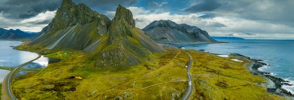
Jakie są popularne miejsca na wycieczki quadami i buggy na Islandii?
Popularne miejsca to półwysep Reykjanes, Złoty Krąg, południowe wybrzeże i obszary wulkaniczne w pobliżu Reykjaviku. Na przykład ta wyjątkowa 2-godzinna wycieczka quadem zabierze Cię na lodowiec Snaefellsjokull. Istnieje jednak wiele opcji wycieczek dostępnych w całym kraju, z których każda oferuje wyjątkowe wrażenia.
Jaki rodzaj terenu napotkam podczas tych wycieczek?
Jaka jest najlepsza pora roku, aby wybrać się na wycieczkę quadem lub buggy na Islandii?
Czy są miejsca, w których można się zatrzymać i zrobić zdjęcia podczas wycieczki quadami na Islandii?
Widziałem quady jeżdżące po plażach na Islandii, czy jazda off-road nie jest zabroniona?
Podobno Islandia słynie z ekstremalnych warunków pogodowych. Czy wycieczka quadem zostanie odwołana, jeśli będzie padać?
Jaki sprzęt jest zapewniony? Co muszę zabrać ze sobą na wycieczkę quadem i buggy?
Co jest lepsze, quady czy buggy podczas mojej wycieczki po Islandii?
Czy mogę wziąć udział w wycieczce quadami lub buggy do wraku samolotu DC na południowym wybrzeżu Islandii?
Czy wycieczki quadami są organizowane z Reykjaviku?
Czy mogę połączyć wycieczki quadami lub buggy z innymi atrakcjami, lub zwiedzaniem Islandii?
Czy muszę rezerwować wycieczki quadami lub buggy z wyprzedzeniem?


Pobierz największą platformę turystyczną na Islandii na telefon i zarządzaj wszystkimi elementami swojej podróży w jednym miejscu
Zeskanuj ten kod QR za pomocą aparatu w telefonie i naciśnij wyświetlony link, aby uzyskać dostęp do największej platformy turystycznej na Islandii. Wprowadź swój numer telefonu lub adres e-mail, aby otrzymać wiadomość SMS lub e-mail z linkiem do pobrania.