
Laugavegur - Day 3 - Hiking through the Highlands

We have hiked all the way from Landmannalaugur to Thorsmörk with the worst weather conditions and the most beautiful views! Our third Day...
(Den deutschen Artikel finden Sie hier: German Version)
The other hikers probably hated us this morning, when my alarm clock ringed at half past 5. But we really wanted to see the canyon nearby - and the last bus from Thorsmörk back to Reykjavik was going to leave at 4 pm. We couldn’t believe our eyes when we pushed open the hut’s door: Could that really be the SUN blinking at us?

The day kept its promise. The first time on our trip we actually felt warm while walking! So warm that we had to get rid of our long woolen underwear and were even able to walk some parts in T-shirts only!
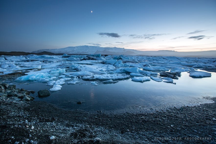
The canyon was worth getting up that early! And so we made good for all the pictures we did NOT take yesterday, due to the bad weather (and the more or less monotonous landscape).

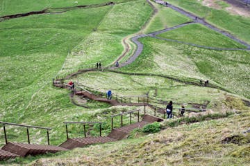
It was already 10 o’clock when we returned to Emstrur and sallied for today’s march to Thorsmörk. The warden’s words in mind that we would need at least 6, maybe 7 hours to reach Thorsmörk and therefore would never catch the bus in time, we kept our breaks short (we were kind of used to it by now) and set a swift tempo. It took 4.5 hours - bamm!! :D
Although our feet, knies and shoulders were badly affected, the sunshine and the bright blue sky made us walk elatedly and cheerfully. Only stairs-like ascents and descents were kind of challenging… But not as painful as climbing actual stairs the days after!

Maybe it was just because the weather yesterday was so bad - but TODAY the landscape was absolutly dreamlike again. The closer we came to Thorsmörk, the richer the vegetation got. In lieu of the omnipresent moss on barren lava rocks we saw bushes in red, yellow and a vivid green. And every now and then, we even passed a tree! Not especially big ones, but still a miracle every time! :D
Today, we almost welcomed the river - A good opportunity for the feet to evaporate a bit! Besides, we had been told that the river was close to Thorsmörk. Which meant we were almost there!

Nevertheless we nearly managed to get lost on the last meters… But it wasn’t all our fault! The path, that led away from the “road” (In Germany you would rather call it a beaten track…) and, according to the sign, to our destination, ended in a more than hundred meters deep slope. So we went back and followed the road until a group of hikers approached us and told us, that the road would not lead to Thorsmörk either, but ended in nothing. Now we were desperate: The only remaining way was the one back to Landmannalaugur.
But the rescue arrived a few minutes later in form of two Czechs with GPS. With their help we finally found the secret climb-down to the valley of Thorsmörk.
And then we arrived! After 55 kilometer of hiking, 1700 meters in altitude up and 2100 meters down, several blisters and the strangest conversations (that seemed to grew on abstrusity the farther we got)... WE MADE IT!!!

This post is part of a whole series called "Laugavegur - Hiking through the Highlands" in which we describe our experience of hiking all the way from Landmannalaugur to Thorsmörk in 3 days.
You missed the beginning? Click here to read about our First Day: Laugavegur - Day 1 - Hiking through the Highlands
To Day 2: Laugavegur - Day 2 - Hiking through the Highlands
You want to experience it yourself?
Here you can book this trip: Laugavegur Trekking


기타 흥미로운 블로그

요쿨살론부터 비크까지, 꽃보다 청춘 5화
드디어 하늘씨과 쓰리스톤즈가 합류했는데요! 설원을 달리는 모습에 저도 아이슬란드가 엄청 그리워졌답니다. 빙하와 빛나는 요쿨살론 첫번째로 향한 요쿨살론(Jokulsarlon)은 아이슬란드의 대표적인 명소 중 하나랍니다. 영어로 Glacier lagoon 이라고도 하는데요. 방송에 나온 것처럼 눈 앞에 보이는 빙하는 빙하수가 흘러서 녹았다 얼었다를자세히 읽어보기스코가포스 폭포부터 오로라까지, 꽃보다청춘 4화를 따라서
여행 5일째, 포스톤즈가 처음으로 향한 곳은 아이슬란드 남부에 있는 스코가포스 폭포(skogasfoss)입니다. 아이슬란드 남부의 대표적인 폭포 중 하나에요. 방송에서는 들르지 않았지만 스코가포스 거의 바로 옆에 위치한 셀리야란드스포스(seljalandsfoss) 폭포와 함께 같이 들르곤 한답니다. 스코가포스 폭포는 폭포의 물줄기 끝까지 올라갈 수 있단자세히 읽어보기꽃청춘을 따라서
요즘 인기리에 방영되고 있는 꽃보다 청춘 아이슬란드편! 저도 매주 빼놓지 않고 시청하고 있습니다. 많은 분들께서 포스톤즈의 발랄한 매력과 아이슬란드의 놀라운 경치에 빠져드셨을 것 같습니다! 이번에는 꽃보다 청춘을 따라서 아이슬란드를 한번 가보도록 해요! 사실 아이슬란드가 한국에서 그렇게 가기 쉬운 나라는 아닙니다. 거리도 멀고 항공권도 비싸고! 우자세히 읽어보기


아이슬란드 최대의 여행 마켓플레이스를 전화에 다운로드하여 전체 여행을 한 곳에서 관리하세요
전화 카메라로 이 QR 코드를 스캔하고 표시되는 링크를 누르면 아이슬란드 최대의 여행 마켓플레이스를 주머니에 넣을 수 있답니다. 다운로드 링크가 포함된 SMS 또는 이메일을 받으려면 전화번호 또는 이메일 주소를 추가하세요.


