参加人数には限りがあります
早めのお申し込みがお得です
最安値をお約束します
手数料なし
セットでお得!スナイフェルスネス半島、ゴールデンサークル、氷河湖
ホテルの予約ができた!あとはアクティビティだけという方におススメしたいコンボツアーです。Guide to Icelandスタッフが選定したツアーのコンビネーションを申し込めば、簡単に旅行プランが完成!
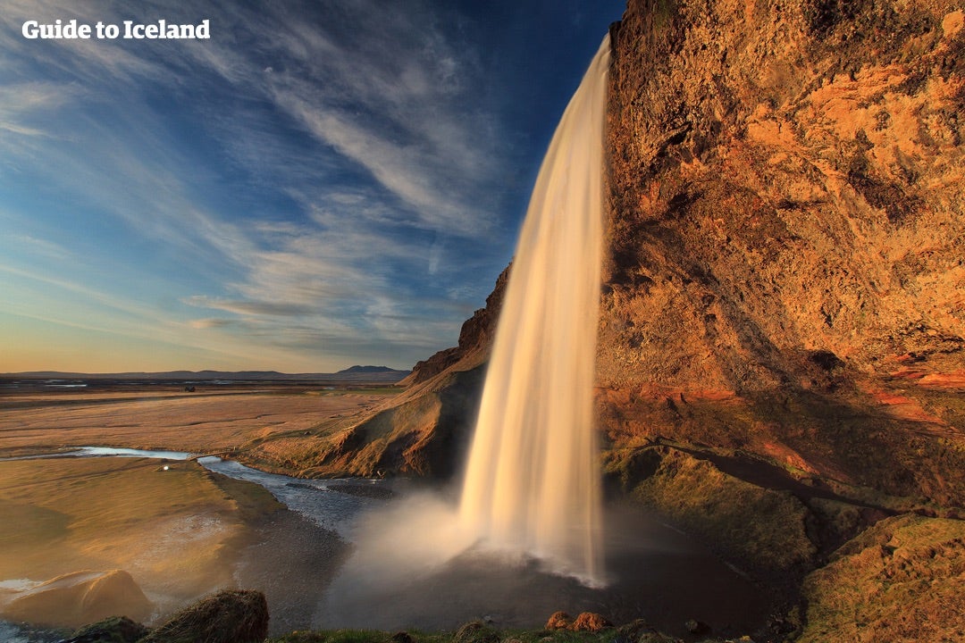
このコンボツアーはアイスランドの観光の目玉となるスナイフェルスネス半島、ゴールデンサークル、ヨークルスアゥルロゥン氷河湖を訪れる3つの日帰りツアーが含まれています。全てのツアーはレイキャビク市内からの送迎付き、ツアー後はお客様ご自身で手配した宿泊先でお休みください。ピックアップ場所は宿泊先に近いホテルをお選びいただけます。最寄りのピックアップポイントがわからないという方はお気軽にお問い合わせください。
このセットツアーを予約しましたら、セットツアー用の1つのバウチャーが発行されます。その後、それぞれの日帰りツアーのバウチャーをご予約時のメールアドレスに送ります。各バウチャーからピックアップ場所を変更もできますので、同じホテルにずっと泊まる必要はございません。
*ピックアップ場所の変更はツアー出発時刻の24時間前までです。詳しくは「ご利用規約」をご確認ください。
ツアー概要
- ツアー時期: 6月. - 10月.
- 所要時間: 3 日間
- アクティビティ: ハイキング, 観光, クルージング, 温泉, カルチャー, 野鳥観察
- 難易度: ☆
- 最低年齢: 8 歳
- ツアーガイド言語: English
- ハイライト: ゴールデンサークル,
The Golden Circle is a 300 km route to the 3 most popular natural attractions in Iceland. The Golden Circle consists of Geysir, Gullfoss and Thingvellir.
See this for Golden circle tours.
Geysir area
Geysir is a geyser that gives its name to hot springs all over the world. But although Geysir itself is not active anymore the area features spectacular hot springs such as the powerful Strokkur (spouting a vast amount of water every 10 minutes, regularly about 15-20 meters into the air), Smidur and Litli-Strokkur.
Gullfoss waterfall
The 'Golden Waterfall', is the second part of the Golden Circle, and one of the most beautiful and powerful waterfalls in Iceland, plummeting 32 meters into the river gorge of the popular rafting river Hvita. It is Iocated about 10 km from Geysir.
Thingvellir national park
The largest attraction of the Golden Circle is Thingvellir National Park. The Icelandic parliament was founded there in 930 and remained until the year 1798.
Today it is a UNESCO World Heritage Site and one of the most important places to visit in Iceland, not just for its historical and cultural values, but for also its magnificent landscape.
Thingvellir is surrounded by a beautiful mountain and volcano range and is the site of a rift valley, where the tectonic plates meet, marking the crest of the Mid-Atlantic ridge.
Of particular note at Thingvellir are the magnificent Almannagja gorge, and the beautiful lake Thingvallavatn, the largest lake in Iceland. The popular Gjabakkahellir lava cave is also in the area.
The fissure Silfra is located by Thingvallavatn, Iceland's largest lake, and is famous for its clear waters and popular for diving and snorkeling, as you can literally swim between continents.
南アイスランド,South Iceland is the most popular part of the country and contains some of the most beautiful natural attractions in Iceland, among them the Golden Circle, some of Iceland's most famous active volcanoes as well as the beautiful Jokulsarlon glacier lagoon.
Geography
South Iceland is usually divided into the fertile South Icelandic lowlands between Hellisheidi and Eyjafjallajokull volcano on the one hand - and on the other hand the eastern part with the big volcanic glaciers Eyjafjallajokull and Myrdalsjokull (home of Katla) and flattened sands stretching towards the sea.
The South Icelandic lowlands
The South Icelandic Lowlands stretch nearly 100 km from Hellisheidi in the west towards Eyjafjallajokull in the east as a very flat and fertile farming land. From the shore the lowland stretches about km towards the inland. This is the best agriculture area in Iceland. The whole area is geologically very young, mainly of tuff type, formed during the Ice Age by the lava flows of the numerous volcanoes of the area. The area is indeed surrounded by volcanically active mountains on all sides. The glacier rivers of the area have helped filling the lavas with sand and clay, leaving it more and less smooth and fertile. Very strong earthquakes are found in this area as well.
The most active volcanoes of the area are Hekla and Eyjafjallajokull. No less active and not far off, but on the east side, is Katla, which we’ll adress in the eastern part-section. South of the mainland are the volcanic Westman Islands, famous for the 1973 eruption as well as the eruption in 1963, when Surtsey island was formed. Closely linked to the volcanic activity in the south is the geothermal heat found in many places, the best known being the Geysir area, which forms a part of the famed Golden Circle, which also consists of Gullfoss waterfall , Iceland's most famous waterfall as well as one of its most beautiful, located in the popular rafting river Hvita and Thingvellir National Park, comprising three of Iceland's most beloved natural attractions.
The earthquakes of the area bear witness to the fact that Iceland is still in shape. This is further evidenced by the endless number of fissures in the lavas, fractures in the mountains and certain pieces of lands sinking. The area of Thingvellir is the best known example of this, showcasing the continental drift. Thingvellir is a UNESCO World Heritage Site and the location of the old parliament, Althingi, (now situated in Reykjavik) and one of Iceland's most important sites.
Another of Iceland's most popular attractions is the beautiful Thorsmork valley, situated between Myrdalsjokull and Eyjafjallajokull.
Natural harbour-sites are hardly any on the South shore, due to sand produced by the glacier rivers. A few towns are found in the area, Selfoss being the biggest one, Hveragerdi is another, then there are Hella and Hvolsvollur, all conveniently located by the ring road. By the shore are three fishing villages; Thorlakshofn, Eyrarbakki and Stokkseyri. Thorlakshofn the only one of those that can accommodate modern ships and ferrys. The ferry to the Westman Islands sails from there. A new harbour has been built on the sandy coast opposite the Westman Islands. The whole south shoreline offers some of the most gigantic braker waves that you are likely to see.
Culturewise, in addition to Thingvellir, we reccomend the ancient bishop seat of Skalholt (weekends at Skalholt further offer rich music life). Also, Iceland's most famous saga, Njal's saga takes place in the South lowlands. We further recommend the large reconstructed turfhouse near Stong and the ancient excavated ruins.
For sports, horse riding is popular in the area as well as catching salmon or trout, hiking, and river rafting in Hvita.
The east part of South Iceland.
This is the area south and east of Myrdalsjokull. The volcanic glaciers Eyjafjallajokull (near the border of the eastern and western part) and Myrdalsjokull, dominate the view. The landscape has been shaped by volcanic eruptions and vast sands stretch to the sea. Some agriculture is found here, however, with the farms in a row alongside the mountains. A few large glacial rivers fall down in this area which also has striking waterfalls, such as Skogafoss and Seljalandsfoss.
Eyjafjallajokull is already well known for its 2010 eruption, disturbing air communication all over Europe for many days. Much more serious,however, would be an eruption from Katla, a volcano in the eastern part og Myrdalsjokull.
Katla’s last eruption was in the year 1918, when an enormous flood of water exploded from the glacier in a matter of minutes, threatening the local farmers of the area. Large amounts of ash and muddy material were brought to sea to form a new land of sand, Kotlutangi, later washed away by the sea. No people were killed in this eruption. Eruptions in Katla throughout the ages have further created the vast sand area Myrdalssandur. Sixteen eruptions have been recorded for Katla since 930 at intervals of 13-95 years and the volcano is being closely monitored, as time may draw near to its next eruption.
In the same volcanic system as Katla (geologically speaking), are the Lakagigar craters, northeast of Myrdalsjokull. Those erupted in the years 1783-84; producing the largest amount of lava known in historic times. The ashes hindered the sunlight from reaching down to the surface of Earth, resulting in cold climate over northern Europe.
In this area – what we call the eastern part of South Iceland -, there are many places worth visiting: Solheimajokull is a beautiful glacier in a walking distance (an outlet of Myrdalsjokull); Skogar has a very interesting museum of older time traditions and Skogafoss is only a few km away from there. One of Iceland’s most famous hiking routes, Fimmvorduhals, starts from Skogar. Southwest of the village Vik is one of Iceland’s most spectacular beaches, Reynisfjara. Together with the promontory Dyrholaey, which is the southernmost tip of the mainland of Iceland, it offers a breathtaking view with amazing rock formations, a black pebble beach, an abundance of birds and the powerful waves of the North Atlantic Ocean crashing on the beach.
Further east stretches the world's most vast sand plain, Skeidararsandur. North of the sand is the fascinating Skaftafell preservation area. At its east end, south of Hvannadalshnukur, Iceland's highest peak, is Ingolfshofdi cape, with its rich birdlife, old fishermen's shacks and its lighthouse. Following the shore further east is the incredibly beautiful and ice-filled Jokulsarlon glacier lagoon. Not far off is the region of Sudursveit, featuring the culture center and heritage museum Thorbergssetur, erected in the memory of Icelandic author Thorbergur Thordarson.
レイキャビク,Reykjavik is the capital of Iceland and the northernmost capital of a sovereign state in the world.
Despite a small population (120.000 and more than 200.000 in the Greater Reykjavik area), it is a vibrant city that draws an ever increasing number of visitors. It is the financial, cultural and governmental centre of Iceland. It also has a reputation of being one of the cleanest and safest cities in the world.
Geography
The city of Reykjavik is located in southwest Iceland by the creek of the same name. Throughout the ages, the landscape has been shaped by glaciers, earthquakes and volcanic eruptions and the area is geothermal. Much of the current city area area was subglacial during the Ice Age, with the glacier reaching as far as the Álftanes peninsula, while other areas lay under the sea. After the end of the ice age the land rose as the glaciers drifted away, and it began to take on its present form.
The coastline of Reykjavik is set with peninsulas, coves, straights and islands, most notably the island of Videy, and seabirds and whales frequent the shores. The mountain ring as seen from the shore is particularly beautiful. Mount Esja is the highest mountain in the vicinity of Reykjavik and lends its distinct feature to the whole area. This majestic mountain is also highly popular for climbing. Other notable mountains that can be seen from the seaside are Akrafjall and Skardsheidi and on clear days one may even see as far to the legendary Snaefellsjokull glacier, at the end of the Snafellsnes peninsula.
The largest river to run through the city is Ellidaa in Ellidaardalur valley, which is also one of Iceland‘s best rivers for salmon fishing.
Transportation
There are no trains or trams in Iceland, but most people travel by car. The city also operates a bus system. There are two major harbours in town, the old harbour in the centre and Sundahofn in the east. The domestic Reykjavik Airport is located at Vatnsmyrin, not far from the city centre and close to Oskjuhlid and Perlan. The international Keflavik Airport at Midnesheidi heath then lies around 50 km from the city. Cars, jeeps and bicycles can be readily rented in the city and many organized tours are also being offered.
What to See & Do in Reykjavik
The local arts scene is strong in Iceland, with both annual events and single ones, many of whom have hit the international stage. For the annual ones please check our articles Best Annual Events in Iceland and the Top Ten Festivals in Iceland. Major events taking place in Reykjavik include the Iceland Airwaves, Gay Pride, RIFF (The Reykjavik International Film Festival), The Reykjavik Literature Festival, Cultural Night, the Reykjavik Arts Festival, Food & Fun, the Reykjavik Fashion Festival and the Sónar music festival.
Among famous people from Reykjavik are artists Bjork Gudmundsdottir, Sigur Ros, writers Halldor Laxness (born in Laugavegur) and Arnaldur Indridason and mayor Jon Gnarr. For more well-known and fairly-well known Icelanders, check our article on the subject.
You might also want to check our article on some of the many things to see and do in Reykjavik, such as visiting the city‘s many museums, exhibitions and galleries, checking out live music, visiting the Harpa music hall or the theatres, visiting the lighthouse at Grotta, the main shopping street of Laugavegur, visiting the old harbour and the flea market, going on a bird- and whale watching tour or visiting Videy island. We also have a top ten list of things to do.
Make sure to visit the public square of Austurvollur, one of the city‘s most popular gathering places, where you‘ll also find the national parliament, Althingi, the state church a statue of independence hero Jon Sigurdson, as well as cafés, bars and restaurants. Austurvollur was central in the 2008 protests, along with Laekjargata, home to the House of Government. You are also not likely to miss the great church of Hallgrimskirkja that towers over the city from the hill of Skolavorduholt, wherefrom you‘ll get a great view of the city.
Try a walk by the city pond, greet the many birds that frequent the area and visit the city hall, stationed by its banks. The Hljomaskalagardur is a beautiful park that lies by the pond, it ideal for a nice walk and sometimes concerts get held there. Further off is the campus of the university of Iceland, the Nordic house and the Vatnsmyri wetland, a particularly pleasant place, but be mindful of not disturbing the wildlife there and keep to the pathways.
For a nice swim on a warm day, we particularly recommend Nautholsvik beach.
Visit the Laugardalur valley, home to one of the city‘s best swimming pools, as well as the Asmundarsafn gallery, a beautiful botanical garden and a domestic zoo. A walk by the Aegissida beach, with it‘s old fishing sheds, in the west part of Reykjavik also holds a particular charm. The aforementioned Elllidaardalur valley is also a popular resort.
Another place that offers one of the city‘s best (and free) views is Perlan, up in Oskjuhlid hill. The hill itself is a popular resort, with over 176.000 trees and great opportunities for walking and cycling.
Travel to Alftanes to see the president‘s house at Bessastadir, which is also a historical site in it‘s own right, having been the educational centre of Iceland for centuries. Nearby is a beautiful lava field, Galgahraun, well worth a visit, though there is currently an environmental struggle going on as to it‘s future state.
The city is furthermore a short drive from many of Iceland‘s major attractions, most famously the Golden Circle and the Blue Lagoon. In close vicinity you‘ll also find the Heidmork preservation area, a favourite pastime resort of the people of Reykjavik, as well as the Blue Mountains, one of Iceland‘s most beloved skiing venues.
Check our Best of Reykjavik guide further for tips on the best cheap things to do in Reykjavik, some of the best restaurants in the city, happy hours, the top ten value places to eat and our two articles on the famous Reykjavik nightlife; Nightlife in Reykjavik and Nightlife and mating.
Finally, we‘d like to stress that these are only some suggestions of the many things you might check out in Reykjavik. Whatever you choose to do, we hope you‘ll be able to make the most of your visit and we wish you a pleasant stay in our capital.
ヨークルサロン氷河湖,Jökulsárlón is Iceland’s most famous glacier lagoon. Conveniently located in the southeast by Route 1, about halfway between the Skaftafell Nature Reserve and Höfn, it is a popular stop for those travelling along the South Coast or around the circular ring road of the country.
Geography
As a glacier lagoon, Jökulsárlón is a lake that is filled with the meltwater from an outlet glacier. In this case, it is Breiðamerkurjökull, a tongue of Europe’s largest ice cap, Vatnajökull.
It stands out, however, due to the fact that it also fills with icebergs breaking from the glacier, some of which tower several stories high.
These icebergs, other than their scale, are notable for their colouration. Although they are, as expected, largely white, most are also dyed electric blue in part, with black streaks of ash from eruptions centuries past.
When the icebergs finally make it across the lagoon, they either drift out to sea or wash up on the nearby shore. Because of the way they glisten against the black sands of Breiðamerkursandur, this area has been nicknamed ‘the Diamond Beach’.
In spite of being a rather recent formation, Jökulsárlón is the deepest lake in the country, with depths reaching 248 metres. With a surface area of 18 square kilometres, it is also growing to be one of the largest.
History
Jökulsárlón has not been around since Iceland’s settlement; it only formed around 1935. This was due to rapidly rising temperatures in the country from the turn of the twentieth century; since 1920, Breiðamerkurjökull has been shrinking at a dramatic rate, and the lagoon has begun to fill its space.
Today, the expansion of Jökulsárlón is accelerating. As recently as 1975, it was just 8 square kilometres, and now that size has more than doubled.
In the relatively near future, it is expected that the lagoon will continue to grow until it becomes a large, deep fjord.
Though a dark omen for Iceland’s glaciers and ice caps in general, the retreat of Breiðamerkurjökull has resulted in an incredibly beautiful, if temporary, site. This has not been overlooked by Hollywood.
Jökulsárlón has been featured in the James Bond films A View to Kill in 1985 and Die Another Day in 2002, 2001’s Lara Croft: Tomb Raider, and 2005’s Batman Begins.
In 2017, Jökulsárlón was enveloped into the Vatnajökull National Park, thus it is now fully protected by Icelandic law.
Wildlife
Because of the wealth of herring and capelin that the tides bring into the lagoon, Jökulsárlón is somewhat of a hot-spot for Iceland’s wildlife.
In summer, it is a nesting site for Arctic Terns; stay well away from this area, as these birds are notorious for the fierceness with which they protect their eggs, dive-bombing the heads of any they see as a threat. Skuas also nest on the lake’s shores in this season.
Seals can be reliably spotted here throughout the year, swimming amongst or else hauling out on the icebergs. Jökulsárlón provides them with a safe haven to rest and socialise, especially considering the waters of southeast Iceland are renowned for their population of orcas.
ヴァトナヨークル氷河,Vatnajökull glacier is the largest ice cap in Iceland and the third largest glacier in Europe, covering 8% of the island's landmass. Vatnajökull National park can be found in the south west of Iceland and is a popular spot for activities like glacier hiking from Skaftafell, boat tours and ice caving tours from Jökulsárlón glacier lagoon, both of which are part of Vatnajökull national park.
Facts about Vatnajökull
- Surface: 8,100 km2
- Average thickness: 400 - 600 m
- Maximum thickness: 1,000 m
- Height: 1,400 - 1,800 m
- Highest peak: 2,200 m (Hvannadalshnjúkur)
Information about Vatnajökull
Vatnajökull Glacier belongs to the greater Vatnajökull National Park, which encompasses the former national parks Skaftafell, in the southwest, and Jökulsárgljúfur, in the north. Vatnajökull's highest summit is Hvannadalshnjúkur which rests on top of a stratovolcano known as Öræfajökull.
Underneath the glacier rests some of the most active volcanoes in the country, the most notable being Grímsvötn, Öræfajökull and Bárðabunga. Volcanic activity in the region has occurred on and off throughout the centuries, and many geologists believe that such a period is overdue for immediate future. If their calculations are correct, it would mean significant volcanic activity for Vatnajökull over the scope of the next half century.
The glacier boasts of over 30 outlet glaciers, which are channels of ice that flow out of ice caps but remain constrained on the sides of the valley. The major outlet glaciers of Vatnajökull include Dyngjujökull in the north, Breiðamerkurjökull and Skeiðarárjökull to the south. To the west, one can find the outlet glaciers Síðujökull, Skaftárjökull and Tungnaárjökull.
Glaciers are in constant motion underneath their weight; as they form over the centuries, the accession of snow exceeds its melting, creating a constant "push" on the ice cap. Each year, due to the melting ice water, new ice caves form that disappear come spring.
- Click here for a selection of Ice Cave tours
Numerous rivers run out of Vatnajökull, making up some of the greatest glacial rivers in Iceland:
- Tungnaá (west)
- Köldukvísl (west)
- Þjórsá (west)
- Jökulsá á Fjöllum (north)
- Skjálfandafljót (north)
- Jökulsá á Brú (north east)
- Jökulsá í Fljótsdal (north east)
- Jökulsá í Lóni (south)
- Hornafjarðarfljót (south)
- Jökulsá á Breiðamerkursandi (south)
- Skeiðará (south)
- Núpsvötn (south)
- Hverfisfljót (south)
- Skaftá (south)
Vatnajökull National Park
Vatnajökull National Park, in its current state, was established in June 2008. The park now covers an area of 14.141 km2, making it the second largest national park in Europe. Vatnajökull National Park has 14% coverage over the whole island of Iceland.
Rivers divide the highland plateau to the north of the park; an area that sees massive glacial flows in the summertime. The volcanic table mountain Herðubreið towers over this particular region, along with volcanoes Askja, Snæfell and Kverkfjöll.
The canyon Jökulsárgljúfur was carved out by glacial floods centuries ago. At the upper end of the canyon, you'll find Dettifoss, the most powerful waterfall in Europe. Further north, the horseshoe-shaped canyon Ásbyrgi is believed to have formed when Óðinn's horse, Sleipnir, stepped his foot down from the heavens.
East around Snæfell, one can find wetlands and ranges, home to roaming herds of wild reindeer and abundant birdlife. Steep mountain ridges make up the south side of Vatnajökull, where outlet glaciers crawl in between the ridges onto the lowlands. The sandy plains of Skeiðarársandur also lie to the south as they reach out to sea. The glacial river Skeiðará runs through this vast desert.
One of Iceland's most visited landmarks is the Jökulsárlón glacier lagoon, which sits at the head of outlet glacier Breiðamerkurjökull. There, large icebergs that have broken off the glacier gather to float in the lake before ending up in the Atlantic Ocean, or on the nearby Diamond Beach.
- Click here for a selection of Jökulsárlón tours
The Future of Vatnajökull
The volume of Vatnajökull reached its peak around 1930 but has since been in a steady process of decline. Because of rising levels of global temperature, approximately over the last 15 years, Vatnajökull has on average lost about a metre of its thickness annually.
If temperature levels continue to rise, the glacier could be all but gone nearing the end of the next century, leaving only small ice caps on top of the highest mountain summits.
Vatnajökull and Jökulsárlón in Popular Culture
- HBO's Game of Thrones (season 2, 2012)
- Batman Begins (2005)
- James Bond: Die Another Day (2002)
- James Bond: A View to a Kill (1985)
スナイフェルスヨークトル氷河,Snæfellsjökull (1446 m) is an ice-capped volcano found on the tip of the Snæfellsnes Peninsula in West Iceland.
Though many consider Snæfellsjökull to simply be a particularly impressive ice cap, it is, in fact, a 700,000-year-old glacier-capped stratovolcano. The mountain is actually called "Snæfell" (Snowy Mountain), though the “jökull” (Glacier) is often added to help distinguish it from other mountains of the same name. For the first time in recorded history, Snæfellsjökull had no snow or ice at its peak in August 2012, causing concern amongst locals that climate change is threatening the nature of the mountain.
On clear days, one can see Snæfellsjökull from Iceland’s capital city, Reykjavik, approximately 120 kilometres away over Faxa Bay, making for an impressive sight—and a tick off the bucket list if you can’t make it to travelling across the Peninsula itself. The volcano makes up just a small part of the larger Snæfellsjökull National Park.
History
Nearby villages include Hellissandur, Rif and Ólafsvík, all of which were commercial and fishing hubs throughout the peninsula’s long history of human inhabitance. Fishing took off primarily in the 13th-Century, with fishing stations being built in all areas with easy access to the open ocean.
One notable example would be the settlement of Dritvík, one of the largest fishing stations in Iceland at the time, utilising around 40–60 boats and employing between 200–600 people. Fishing in the region declined during the 19th century due to a change in Iceland’s fishing practises, though it is still an important source of livelihood for those living on the Peninsula.
Snæfellsjökull has, for centuries, been considered to be one of the world’s ancient power sites, a source of mysticism, energy and mystery for the peninsula’s superstitious population. This likely has something to do with the stratovolcanoes place in the Icelandic sagas; the feature takes a prominent role in Bárðar saga Snæfellsáss, a late 14th-century saga that tells the story of Bárður, half-human-half-troll, who became the “guardian spirit of Snæfellsjökull.”
In Literature
Snæfellsjökull serves as the entrance to a fantastical subterranean world in Jules Verne’s classic 1864 novel “Journey to The Centre of The Earth.” Given its central place in the novel, Snæfellsjökull has become one of the most popular spots for visitors in Iceland and has inspired a wealth of writers, poets and artists.
Since “Journey to The Centre of The Earth”, Snæfellsjökull has appeared in the Blind Birds trilogy by Czech SF writer Ludvík Souček (partially based on Jules’ work) and in Under The Glacier, a novel by Iceland’s only Nobel laureate, Halldor Laxness.
Nearby Attractions
Along with the glacier, attractions include the two nearby basalt cliffs called Lóndrangar and the many fascinating lava formations at the beautiful Djúpalonssandur beach, such as the arch rock Gatklettur. At Djúpalonssandur, one can also test their strength just as the ancient sailors once did with the four "strength" stones, Amlóði ('Useless'), Hálfdrættingur ('Weakling'), Hálfsterkur ('Half Strength') and Fullsterkur ('Full Strength'). In the area, one can also explore the Saxhóll volcano crater and 'the singing cave' Sönghellir, which is named after the loud echoes inside.
スコゥガフォスの滝,Skógafoss is one of the country’s biggest and most beautiful waterfalls with an astounding width of 25 meters (82 ft) and a drop of 60 meters (197 ft). Due to the amount of spray the cascade produces, a rainbow is present any time the sun emerges from behind the clouds.
Located on the Skógá river, this mighty cascade is clearly visible from Route 1 and is an excellent place to stop and stretch the legs while travelling Iceland’s South Coast. The river below Skógafoss holds a large char and salmon population and is thus a favourite spot for fishermen in the summer.
The land underneath the waterfall is very flat, allowing visitors to walk right up to the wall of water. Keep in mind, however, that this will get you drenched. Skógafoss can also be viewed from the top as a steep staircase leads to an observational platform above the cascade.
Geography
Skógafoss is located near the small village of Skógar, south of the Eyjafjallajökull glacier volcano. There you’ll find the Skógasafn folk museum, an open-air museum with both old wooden houses and turf houses, as well as a regional museum with various artefacts from this area.A part of the Skógasafn Regional Museum is the Museum of Transportation, which showcases the history and evolution of transportation, communication and technologies in Iceland. There, you can see how this nation evolved from the age of the working horse to the digital communications of the 21st century.
The Skógasafn museum also includes a café and a museum shop, and in the village of Skógar, you will find both a hotel and a restaurant.
At the eastern side of Skógafoss, you will find one of Iceland’s most famed hiking routes; the Fimmvörðuháls pass. The 22 km (14 mi) trail takes you along Skógá river, between two glaciers, Mýrdalsjökull and Eyjafjallajökull, before ending in the beautiful Þórsmörk valley.
Folklore
A gold ring is on display at the Skógasafn museum. According to legend, the ring is from a chest that was owned by Þrasi Þórólfsson, one of the first Viking settlers in the area. Folklore states that before his death in 900 AD, Þrasi buried a chest filled with gold in a cave behind Skógafoss waterfall.
Many attempts were made to retrieve the chest after Þrasi’s death, and years later, locals managed to grasp a ring on the side of the chest. As they pulled, the ring broke off, and the treasure was lost forever. The ring was then given to the local church before it made its way to the museum.
セリャランズフォスの滝,Seljalandsfoss is a waterfall, situated on the South Coast of Iceland, with a drop of 60 metres (200 feet).
Due to the waterfall’s close proximity to the Ring Road and impressive natural features, it is one of the most famous and visited falls in the whole country. Majestic and picturesque, the waterfall is one of the most photographed features in the whole of Iceland.
Geology and Surroundings
Seljalandsfoss waterfall, part of the river Seljalandsá, has its origins underneath the glacier volcano Eyjafjallajökull. The cascade of the falls is relatively narrow. However, it used to be wider until a flood in 1976 altered the shape of the cliffs from which the waterfall tumbles. The rainfall during the day of the flood measured 101 millimetres (4 inches), which caused a significant rise in the water levels of rivers in the area. This event caused a new crack to form in the cliffs, that subsequently redirected the width of the falls.
The cliffs themselves are the remnants of a former coastline, which now separates the lowlands from the Highlands of Iceland. The same can be said of Seljalandsfoss’s equally famous neighbour, Skógafoss waterfall.
The most distinguished feature of Seljalandsfoss is a natural pathway that stretches all the way around it. The cliffs behind the falls, therefore, form an accessible cave. Visitors can easily walk this path, although they should be prepared to get dampened due to the perpetual mist of the falls, which also tends to make the rocks of the pathway slippery. During the winter season, it is highly advised not to walk around the falls since the icing makes the walk too hazardous.
However, floodlights have been set up on both sides of the waterfall, which impressively illuminate the scene during dark winter nights. The lights were installed in 2001 due to the growing popularity of the falls as a tourist destination.
After visiting Seljalandsfoss, it is common for visitors to continue north to the waterfall Gljúfrabúi, which is found partially hidden behind a rock face. Because of Seljalandsfoss extreme popularity, Gljúfrabúi is widely considered an additional hidden gem of the scene.
Visitor Centre Controversy
In 2017, it was announced that a visitor’s centre was to be constructed near the falls. The design of the building indicates that it would be 7 metres (23 feet) high and 2,000 square metres (21,500 square feet) in size. Landowners in the area opposed to the idea, proclaiming that the centre would greatly alter the natural appearance of the waterfall’s renowned scenery.
The project has neither been fully approved nor wholly cancelled, with ideas surfacing of either significantly reducing the size of the construction, or moving the visitor centre’s location further away, for instance to the nearby farmstead Brekkuhorn.
Seljalandsfoss in Popular Culture
Along with a multitude of South Iceland’s most famous natural attractions, Seljalandsfoss can be seen in Justin Bieber’s music video for his song ‘I’ll Show You’.
The waterfall was also a featured waypoint during the first leg of the sixth season of The Amazing Race, an American reality TV series.ゲイシールの間欠泉,Geysir is a dormant hot spring in the geothermal area, Haukadalur Valley, found in South Iceland. Making up just one of the attractions along the world famous Golden Circle sightseeing route, alongside Þingvellir National Park and the mighty Gullfoss waterfall, Geysir is most well-known for having lent its name to geysers around the world.
Geography
Though Geysir itself is rarely active these days, Haukadalur Valley boasts a plethora of hot springs, including the powerful Strokkur, Smiður and Litli-Strokkur. Strokkur is, arguably, the country’s most famous hot spring, shooting vast jets of boiling water from twenty metres (65 ft) up to forty metres (130 ft) high. Don’t worry about missing this incredible spectacle of nature as Strokkur erupts every five to ten minutes, just make sure to have your camera ready.
Geysir is much larger, but years can go by between eruptions at Geysir. When it does erupt, the water can shoot up in the air as high as 70 metres (230 ft)!
Just five minutes walk north of Geysir a wealth of fumaroles emanating steam and gas into the cool Icelandic air can be found. Aside from watching the hypnotic pillars of steam, you will also be able to observe the yellow sulphuric stains along the fumaroles themselves, a result of the steam crystallising around the rock bed.
At the southern part of the valley, Þykkuhverir, you‘ll find various bubbling mud pots. These spooky brown cauldrons are actually fumaroles that boil up through the loose ground; after a dry spell, these mud pools are likely to transform into a hardened fumarole.
Nearby Attractions
About 2 km from Geysir is a preserved natural pool called Kúalaug. It has room for 3-5 people at a time, but care should be taken, as the area around the pool is very delicate. The temperature is 39-43°C, depending on where you are positioned in the pool. The water is slightly muddy, as the pool is built on soil, and the bottom is slippery due to algae, so caution is advised when relaxing here.
Haukadalur has also seen a rise in re-forestation in recent times thanks to continued experiments and research in the area. Today, Haukadalsskógur is one of the largest forests in South Iceland, boasting accessible walking paths (also for wheelchair users), fascinating vegetation and The Tree Museum, built in the memory of forester Gunnar Freysteinsson.
History
Haukadalur has been a church site since ancient times and has been inhabited since the Age of Settlement. Given its historic value, it should be noted that scholar, Ari “The Wise“ Thorgilsson, grew up there; it was also where the first pastoral school in Iceland was built. The current wooden church was last rebuilt in 1938 but its architectural style dates back to 1842, making it one of the oldest of its kind in Iceland.
For accommodation, Hotel Gullfoss is approximately 7 km from the Geysir area, and closer still is Hotel Geysir on the other side of the road from the attraction, where you will also find a restaurant, café and a souvenir shop.
グトルフォスの滝,Gullfoss (translated to ‘Golden Falls’) is one of Iceland’s most iconic and beloved waterfalls, found on the Hvítá river canyon in south Iceland. The water in Hvítá river travels from the glacier Langjökull, finally cascading 32m down Gullfoss’ two stages in a dramatic display of nature’s raw power.
Because of the waterfall’s two stages, Gullfoss should actually be thought of as two separate waterfalls. The first, shorter stage of the waterfall is 11m, whilst the second stage is 21m. The canyon walls on both sides of the waterfall reach heights of up to 70m, descending into the 2.5km long Gullfossgjúfur canyon (geologists indicate that this canyon was formed by glacial outbursts at the beginning of the last age.)
In the summer, approximately 140 cubic metres of water surges down the waterfall every second, whilst in winter that number drops to around 109 cubic metres. With such energy, visitor’s should not be surprised to find themselves drenched by the waterfall’s mighty spray-off.
Gullfoss makes up a part of the highly popular Golden Circle tour, alongside Geysir geothermal area and Þingvellir National Park.
History
In the early days of the last century, Gullfoss was at the centre of much controversy regarding foreign investors and their desire to profit off Iceland’s nature. In the year 1907, an English businessman known only as Howells sought to utilise the waterfall’s energy and harboured ambitions to use its energy to fuel a hydroelectric plant.
At the time, Gullfoss was owned by a farmer named Tómas Tómasson. Tómas declined Howell’s offer to purchase the land, stating famously “I will not sell my friend!” He would, however, go on to lease Howells the land, inadvertently beginning the first chapter of Icelandic environmentalism.
It was Tómas’ daughter, Sigríður Tómasdóttir, who would lead the charge. Having grown up on her father’s sheep farm, she sought to get the lease contract nullified, hurriedly saving her own money to hire a lawyer. The ensuing legal battle was an uphill struggle; the case continued for years, forcing Sigríður to travel many times by foot to Reykjavík if only to keep the trial moving. Circumstances became so difficult that Sigríður threatened to throw herself into the waterfall if any construction began.
Thankfully, in 1929, the waterfall fell back into the hands of the Icelandic people. Today, Sigríður is recognised for her perseverance in protecting Gullfoss and is often hailed as Iceland’s first environmentalist. Her contribution is forever marked in stone; a plaque detailing her plight sits at the top of Gullfoss.
Restaurant / Cafe
Besides Gullfoss, visitors can enjoy the views from Gullfoss Cafe, a locally run delicatessen that serves a wide variety of refreshments and meals. The menu has options to tantalise everyone’s taste buds; hot soups, sandwiches, salads and cakes. There is also a shop on site where visitors’ can browse and purchase traditional Icelandic souvenirs.
エイヤフィヤットラヨークル火山,The glacier volcano of Eyjafjallajokull (1651 m) is located at the borders of the South Icelandic highlands. It featured prominently in world news in 2010 when ash from its eruption halted air traffic in Europe.
An ice cap of about 100 km with several outlet glaciers covers the caldera of Eyjafjallajökull that stands at the height of 1651 meters. The diamaeter of its highest crater is around 3-4 km2 wide and the rim has several peaks.
Eyjafjallajokull glacier volcano lies north of Skogar, and to the west of Myrdalsjokull glacier and the massive volcano there; Katla.
Eyjafjallajokull is thought to be related geologically to Katla in Myrdalsjokull and eruptions in the former have often been followed by eruptions in the latter.
The 2010 eruptions
The end of 2010 saw some small seismic activity that gradually increased and resulted in a small eruption in March of 2010, characterized by a flow of alkani-olivine basalt lava.
This first stage lasted until April 12th and created the volcanic craters Magni and Modi at the Fimmvorduhals trail. They are so far Iceland's newest vocanic craters, and still eminate steam with lava glowing under the surface.
However it was the second phase of the eruption that started on April 14th that created the huge ash cloud that rose about 9 km into the skies.
This eruption halted air traffic in Europe for days, and its estimated that as many as 107.000 flights may have been cancelled during the week it lasted.
The ejected tephra measured around 250 million cubic meters. This ash cloud lasted for six days and some more localized disruption continued into May. The eruption was officially declared to be over in October 2010, as the snow on the glacier had ceased to melt.
Future volcanic developments?
Eyjafjallajokull erupted in years 920, 1612 and again 1821-1823.
Its latest eruptions were the two that occurred in 2010.
Future volcanic developments remain unclear. The area is still highly active and can be quite unpredictable. It continues, however, to be closely monitored by The Icelandic Meterological Office.
シングヴェトリル国立公園,Þingvellir National Park is Iceland’s only UNESCO World Heritage site and one of the major stops on the world famous Golden Circle sightseeing tour, alongside Haukadalur Geothermal Valley (Geysir) and Gullfoss Waterfall. Just to the south, as well as a part of the park is Þingvallavatn, Iceland’s largest natural lake.
Geography
The first thing that visitors to the National Park notice is its sheer aesthetic beauty; dried magma fields, covered in Icelandic moss, sit carved by glacial springs and surrounded by a bowl of ancient mountain peaks.
Two of the greatest attractions in the park are the exposed North American and Eurasian tectonic plates; it is one of the only regions in the world where you can see geology such as this on land. Visitors are encouraged to walk along the North American tectonic plate, where they can read more about the area’s fascinating formation and history.
History
Þingvellir can be anglicised to “Fields of Parliament”, a nod to the area’s fascinating history and relevance to Icelandic culture. It is here, after all, that the world’s first democratically elected parliament that remains functioning, the Althing, was formed in 930 AD.
This saw the birth of the Old Icelandic Commonwealth, a time of independence and freedom for the Icelandic people before they became constituents of the Norwegian monarchy. Sessions would continue to be held at Þingvellir until 1798.
Another major reason as to why Þingvellir is considered so important to Icelanders is the fact that this is where the decision was made to abandon the belief of Paganism and the Norse Gods, instead adopting Christianity in 1000 AD. This turning point in history was left to the pagan lawspeaker, Thorgeir Thorkelsson, who rested on the choice for one day and one night before reappearing to share his decision.
Silfra Fissure
Þingvellir is one of the most widely visited attractions in Iceland, in large part due to the fact that it is home to the glacial spring, Silfra Fissure, one of the top 10 sites in the world for snorkellers and scuba divers.
Silfra (meaning “Silver”) is a submerged ravine within the park, boasting visibility of up to 100 metres and a temperature just above freezing. Participants in these tours will be attired at the Silfra carpark in neoprene hoodies and gloves, as well as an undersuit and drysuit for thermal protection.
ストロックル間欠泉,Strokkur (Icelandic for "churn") is one of the most famous hot springs in Iceland and belongs to the famous Golden Circle.
Strokkur is a fountain geyser in the Geysir geothermal area in the southwest part of the country, east of Reykjavik, near Hvítá river.
Strokkur is a powerful hot spring and an impressive sight. It erupts about every 4–8 minutes and spouts water to a height of 15 – 20 m, sometimes up to 40 m.
スナイフェルスネス半島,Snaefellsnes is a large peninsula extending to the west from West Iceland ending with a national park, Snaefellsjokull National Park, where the glacier towers over the scenery, as can sometimes be seen from Reykjavik, lending its beauty to the area.
Snaefellsnes peninsula
The peninsula stretches over 100 km to the west as a mountain ridge that includes active volcanoes and is unique in the variety of mountains found.
A few small and beautiful villages are located on the south side and a few fishing villages are on the north side: Rif, Hellissandur, Olafsvik, Grundarfjordur and Stykkisholmur. The last one is highly popular for travelers, featuring a volcano museum and a ferry that takes you across the fascinating Breidafjordur bay to Brjanslaekur on the south border of the Westfjords.
Other museums you might want to check out are the Maritime Museum at Hellissandur, the regional museum Pakkhusid at Olafsvik, and, last but not least, the shark museum at Bjarnarhofn, indeed listed as the nr. 1 Snafellsnes attraction by Lonely Planet Travelers. Also, many of the Icelandic sagas take place at Snaefellsnes.
Snaefellsnes has an abundance of interesting sights. At the national park, you can witness the impressive lava formations of Djupalonssandur creek and test your strength on its four stones, see the two massive lava formations that compries Londrangar, explore the Saxholl volcanic crater and enjoy the echo of 'The Singing Cave', Songhellir. You may also hike on the majestic Snaefellsjokull glacier. The glacier has strong ties with folklore and was the setting for Jules Verne's Journey to the Center of the Earth.
Other sights we can recommend at Snaefellsnes recommend include Raudfeldsgja canyon, east of the national park and the rugged and colourful Berserkjahraun lava field, near Bjarnarhofn, on the north side of the peninsula.
Last, but not least, Snaefellsnes is one of the main setting for Laxdaela saga. Chieftain Snorri godi, Gudrun Osvifursdottir, Bolli Thorlakssson all lived there as well as his namesake Bolli Bollason, the first West Norse member of the Varangian guard, an elite unit of the Byzantine army. Iceland's most famous mass murderer, Axlar-Bjorn, also lived at Snaefellsnes.
Mýrdalsjökull,Mýrdalsjökull is a glacier in the south of the Icelandic highlands. It is the country's fourth largest ice cap, covering nearly 600 kilometres squared, and its highest peak is almost 1500 meters tall. It is most well-known for sitting atop the notorious and explosive volcano, Katla.Mýrdalsjökull is visible from Route 1 on the South Coast, sitting to the north of the village of Vík.
Eruptions beneath Mýrdalsjökull
Since 2010, the world has known of the volcano beneath Eyjafjallajökull; few, however, are aware of the much larger volcano right beside it. Mýdalsjökull conceals Katla, one of the country’s most active volcanoes, having erupted, on average, once every fifty years since 930 AD. Because of the glacier above it, these eruptions tend to cause enormous ash clouds.
The last major eruption beneath Katla was in 1918, in which such huge lahar floods occurred that the southern coastline was extended five kilometres outwards. This area is also very susceptible to glacial floods, or jökulhlaups, during eruptions, even when the lava does not break through the surface of the ice.
Historically, the area was little settled for this reason.
Katla is connected to the same volcanic system as Eyjafallajökull and usually erupts violently a few years after. As the ex-president, Ólafur Ragnar Grímsson said in 2010:
‘The time for Katla to erupt is coming close… it is high time for European governments and airline authorities all over Europe and the world to start planning for the eventual Katla eruption’Katla is monitored heavily, and roads around it closed when seismic activity increases. All road closures around Iceland can be found on Road and Coastal Administration's website.
Tours on Mýrdalsjökull
While there are no eruptions immediately imminent, tours continue to run on Mýrdalsjökull, allowing visitors to enjoy the glacier. It is, for example, possible to snowmobile across its surface throughout the year and take ice caving tours beneath it from October to April, with departures from both Reykjavík and Vík.
Considering the ice caves under Vatnajökull glacier are usually only accessible from November to March, this provides a wider window of opportunity for travellers to Iceland outside of the depths of winter. It should be noted that the caves in Mýrdalsjökull do not have the same blue ice, however.
Tours around Mýrdalsjökull
Mýrdalsjökull can be seen on all South Coast tours that reach Vík and beyond in clear weather. It can also be seen from above on helicopter tours that depart from Reykjavík.
The best perspectives of the glacier, however, can be found on the popular Fimmvörðuháls hiking trail, which goes between Eyjafjallajökull and Mýrdalsjökull. Part of this hike can be done in a day, or you can take the complete route from Þórsmörk to Skógar on a three-day trek.
スカフタフェットル,Photo from Tour to Skaftafell from Reykjavik.
Skaftafell Nature Preserve can be found in Öræfasveit, the western region of Austur-Skaftafellssýsla in Iceland. Skaftafell once used to be a national park in its own right but was merged with the far larger Vatnajökull National Park in 2008.
Skaftafell is notable for its rich flora, growing between sands and glaciers, and for its amazing and contrasting scenery. At Skaftafell, visitors will find a wealth of natural attractions, from cascading waterfalls to panoramic views over this picturesque region.
Like many areas along the South Coast of Iceland, Skaftafell Nature Preserve is known for its glorious hiking trails. You can take short and easy treks to the waterfalls Svartifoss and Hundafoss, as well as to the gorgeous Skaftafell glacier. A little further along, guests will stumble on the mountain, Kristinartindar, as well as the scenic Morsardalur Valley.
Skaftafell is also the perfect base camp for those seeking to climb Iceland’s highest peak, Hvannadalshnúkur, or for those wishing to spend a number of days exploring the region's attractions, including Vatnajökull glacier, Jökulsárlón glacial lagoon and the nearby Diamond Beach. It is also an excellent region to try your hand at a spot of either ice climbing or glacier hiking; both activities are two of the most authentically Icelandic experiences you can partake in whilst in the country.
Skaftafell Visitor Center
Skaftafell also boasts a Visitors Centre, acting as the main information and meeting point for tour operators and independent travellers. At the Skaftafell Visitor Centre, you will find answers to virtually any questions you might have about the greater Skaftafell area, including its history and geology. The Visitors Centre also contains information about nearby hiking trails, recreational options and accommodation.
レイニスフィヤラのブラックサンドビーチ,Reynisfjara is a world-famous black-sand beach found on the South Coast of Iceland, just beside the small fishing village of Vík í Mýrdal.
With its enormous basalt stacks, roaring Atlantic waves and stunning panoramas, Reynisfjara is widely considered to be the most beautiful example of Iceland’s black sand beaches. In 1991, National Geographic voted Reynisfjara as one of the Top 10 non-tropical beaches to visit on the planet.
Reynisfjara is found around 180 km from Iceland’s capital city, Reykjavik, and is a popular stop-off for those taking a sightseeing tour along South Coast. Driving to the beach is particularly easy, taking an approximate two and a half hours from the capital.
Folklore
Upon visiting the beach, travellers will immediately observe rocky sea stacks sitting off the shoreline, known as Reynisdrangar. According to local Icelandic folklore, these large basalt columns were once trolls engaged in trying to pull ships from the ocean. However, as bad luck would have it, the dawn quickly arose, turning the trolls into solid stone.
Another legend tells of a husband whose wife was kidnapped and killed by two trolls. The man followed the trolls down to Reynisfjara where he froze them, ensuring that they would never kill again.
The sea stacks themselves are home to thousands of nesting seabirds. Species that can be found here include Puffins, Fulmars and Guillemots, making it a must-see location for all birdwatchers out there.
Potential Dangers
Visitors to Reynisfjara must be made well aware of the potential dangers present at the beach. First of all, the rolling, roaring waves of Reynisfjara are particularly violent, often pushing far further up the beach than many would expect.
Visitors are advised to never turn their back on the waves, don't go chasing after them and keep a safe distance of 20-30 metres.
Aside from these sudden and dramatic shifts in tide (known as “sneaker waves”), the currents off the shore are infamous for their strength and ability to drag helpless people out into the freezing cold open ocean. A number of fatal accidents have occurred at Reynisfjara, the last of which occurred in January 2017.
ヘルナル,Hellnar is an old fishing village on the westernmost part of the Snaefellsnes peninsula. It used to be one of the largest fishing stations of the peninsula, the oldest record of seafaring there being from 1560.
At the shore are spectacular rock formations. Among them is a protruding cliff called Valasnos. Tunneling into the cliff is a cave renowned for its changing colourful hues, according to the light and sea movement. Large colonies of birds also nest in the area.
At Gvendarbrunnar a.k.a. Mariulind you can taste excellent spring water which is said to have healing powers.
Hellnar hosts the guesthouse for Snaefellsnes National Park and has a very interesting exhibition about the economy of former times and on the geology, flora and fauna of the national park.
アルナルスタピ,Arnarstapi is a village in the southern part of the Snaefellsnes peninsula. The area has several old and charming houses with interesting stories to them and is furthermore renowned for its beautiful nature.
The beach holds a particular attraction. It has an eroded circular stone arch, called Gatklettur, and three rifts, Hundagja,Midgja and Musagja. The interplay of spectacular waves and the light of the sun creates a fascinating spectacle. Large colonies of the arctic tern also nest in the area.
An old horse trail through the lava field Hellnahraun is highly popular for hiking, due to the impressiveness of the surrounding landscape.
Vík í Mýrdal,Vik in Myrdalur valley is the southernmost village on the Icelandic mainland, located around 180 km from the capital Reykjavik.
Vik is important as a service center for the inhabitants and visitors of the marvelous Reynisfjara beach.
Reynisfjara is widely considered one of the most beautiful beaches on earth (see for example Islands Magazine). This black pebble beach boasts an amazing cliff of regular basalt columns called Gardar, which resembles a rocky step pyramid and out in the sea are the spectacularly shaped basalt sea stacks Reynisdrangar. The area has rich birdlife, including puffins, fulmars and guillemots.
キルキュフェルの山,Kirkjufell (“Church Mountain”) is a distinctly shaped mountain found on the north coast of Iceland’s Snæfellsnes Peninsula, only a short distance away from the town of Grundarfjörður.
Kirkjufell takes it’s name from its resemblance to a church steeple, sharpened at the top with long curved sides. From other angles, the mountain can resemble a witch’s hat or even a freshly scooped ice cream.
Photography at Kirkjufell & Kirkjufellsfoss Waterfall
Peaking at 463 m, Kirkjufell holds the honour of being Iceland’s most photographed mountain. Throughout the centuries, Kirkjufell’s striking slopes have acted as a visual landmark for seafarers and travellers.
Walking distance from Kirkjufell, one can find the photogenic waterfall Kirkjufellsfoss (“Church Mountain Falls”), an excellent subject for photographers who can easily frame the mountain in the background. Despite its relatively diminutive height, Kirkjufellsfoss’ three-pronged falls make the waterfall particularly stunning, even for Iceland.
At the base of the mountain, visitors will also be able to find a lake; on calm and clear days, this lake reflects a perfect mirror image of Kirkjufell, only adding to the fantastic photo opportunities around this area. On top of that, the colours of Kirkjufell change with the passing seasons; the summer see it a lush green, full of life, whilst the winter months scar the mountain’s face with a mask of barren brown and white.
Fans of the HBO series Game of Thrones will recognise Kirkjufell as a shooting location from Season 7 of Game of Thrones. The mountain is showcased from the scenes ‘beyond the wall’ when Jon Snow, The Hound and Jorah Mormont, among others, brave the wilderness in hopes of catching an undead wight. Having seen it in a vision, The Hound acknowledges Kirkjufell as “[...] the mountain like an arrowhead.” Even the Games of Thrones producers can’t resist capturing the mountain on celluloid!
Hiking Kirkjufell
There is a fairly steep trail to the top of Kirkjufell, from where there are magnificent panoramas of the surrounding fields, coastlines and rivers. The mountain takes roughly an hour and a half to ascend, and one and a half hours back to the bottom.
Alongside this mountain-track is a steeper route to the peak which involves two points where one needs to rope-climb. This route should never be attempted in the winter, and never without a certified guide. Given the steep elevation, it is highly recommended that you bring a sturdy pair of hiking boots, snacks and water to the trail.
Getting to Kirkjufell
Kirkjufell is extremely close to Grundarfjörður, a small town on the Snæfellsnes Peninsula, approximately two hours drive from Iceland's capital city, Reykjavik. From Grundarfjörður, one travels ten minutes west down Route Snaefellsnesvegur 54 to the base of Kirkjufell. Visitors have plenty of parking space to choose from, all free of charge.
Flúðir,Flúðir is a small-scale village located in the municipality of Hrunamannahreppur in the Southern Region of Iceland.
The village has the river Litla-Laxá running through it into the larger river of Hvítá, and is overlooked by the mountain Miðfell. With a population of just under 400 people, its residency has grown around greenhouse activity and general horticulture, which continues to be the area's main produce.
Being located near the ever-popular destinations Gullfoss and Geysir, the village and its surrounding area are known for being exceptionally green, plentiful and warm because of geothermal activity. The aforementioned rivers are awash with trout and salmon, and the village's surrounding farmlands are acclaimed for their cultivation of plants, beef and dairy.
Sights, services and accommodation
Flúðir has long been a favoured camping destination amongst Icelanders. Visitors can camp at Tjaldmiðstöðin Flúðum or the nearby Álfaskeið, next to the farm Syðra-Langholt.
Since 1999 the particularly luxurious Hotel Flúðir has also been available for accommodation and fine dining. Because of the region's plentiful organic produce, the acclaimed hotel restaurant prides itself in serving solely locally-grown fruits and vegetables.
Another advantage of the geothermal activity includes natural and age-old thermal pools. Although the minuscule Hrunalaug has undergone a great deal of damage lately due to an excessive traffic of visitors, the larger-scale Secret Lagoon at Hverahólmi has been modified to accommodate a much larger number of people, whilst still preserving its natural terrain.
The water in these hot springs stays at a temperature of 38-40° Celcius (100° Fahrenheit) throughout the entire year. Built in the year 1891, The Secret Lagoon is officially the oldest swimming pool in Iceland.
Other sights include the folk museum at Gröf, the golf course Selsvöllur, the horse rental at Syðra-Langholt and Flúðasveppir, the country's largest mushroom manufacture.
レイニスドランガル,Reynisdrangar are rock formations situated near the shore of Reynisfjara beach by the coastal village Vík í Mýrdalur on the South Coast of Iceland.
The formations are large and impending sea cliffs, made up of the rock type basalt, that serve as a vital part of the area’s allure as they shoot dramatically out of the ocean under the looming cliffs of Mt. Reynisfjall.
- Visit Reynisfjara and Reynisdrangar on these South Coast Tours
Dangerous Waves
The village of Vík only houses around 300 permanent inhabitants, but on a daily basis, travellers scouting the South Coast make their way there to visit what has been voted as one of the most beautiful non-tropical beaches in the world. The beach of Reynisfjara, however, can be highly dangerous if proper caution is not taken. As is evident from how the waves of the Atlantic Ocean crash upon Reynisdrangar, the currents here are strong, and sneak waves can easily carry anyone that’s standing too close out to sea. The beach is not for wading, but for admiring, and especially the mighty surf bursting on the base of these rocky cliffs.
Folklore
There is an Icelandic folk tale that explains the origin of the pillars’ eerie appearance. According to legend, a couple of trolls were busy dragging a stranded three-masted ship to shore when the sunlight hit them and turned them into pillars of rock for all eternity. In fact, numerous rock formations in Iceland carry with them tales of trolls or elves, and one has only to look at them to fathom why.
Surroundings & Wildlife
An alternative view of the bewitching cliffs and their surrounding sea can be enjoyed by venturing up Mt. Reynisfjall, by a road to the west of the village. The mountain furthermore functions as a puffin colony every summer, from April to September, meaning guests can enjoy the view in good company. Other birds can be seen gliding around the cliffs such as Arctic terns, fulmars and seagulls.
- See also: Puffin Watching Tours
Öxarárfoss,Öxarárfoss is a waterfall situated within Þingvellir National Park in southwest Iceland.
The waterfall flows out the river Öxará, cascading in two drops over the cliffs of Almannagjá gorge, which marks the eastern boundary of the North American and Eurasian tectonic plates.
Features and Surroundings
The waterfall has a height of 13 metres (44 feet) and an average width of 6 metres (20 feet). The pool of water at the waterfall’s base is dotted with large, smooth rocks, which get especially icy in winter. The waterfall can be visited year round, but expect large crowds during the peak season of the summer.
Öxarárfoss is one of the most popular attractions of Þingvellir, the area in which Icelanders formed the world’s oldest running democratic parliament, called Alþingi, in 930 AD. :ingvellir National Park is also an official UNESCO World Heritage site. Within the park is Iceland’s largest lake, Þingvallavatn, of which Öxará River is a tributary.
Haukadalur,Haukadalur is a geothermal valley in South Iceland on the popular Golden Circle route.
Lying to the north of Lake Laugarvatn, it is home to hot springs, fumaroles, mud pots and geysers, including the famous Great Geysir and the active Strokkur. The area is noted for the vivid colouration of its surrounding hills, caused by elements deep in the earth being brought to the surface by the geothermal activity.
History of Haukadalur
Haukadalur has been mentioned in historic writings as far back as 1294, in which its geysers were described following an earthquake that activated them. Since the 18th Century, it has been drawing visitors to this island, most notably being a favourite destination of Danish royals.
Throughout the 20th Century, images of the Great Geysir erupting at Haukadular began to symbolise Iceland. It’s activity, however, was unreliable, so unnatural efforts were made to stimulate it more regularly, such as lowering the water table in 1935 and pumping soap into it 1981.
These, however, limited the geyser’s long-term activity, so that it rarely goes off today, although, in the early 2000s, it did have a period where it was spouting water over 140 metres (459 ft) high. Even so, the geyser Strokkur is still very active, erupting to heights of 30 metres (98 ft) every five to ten minutes.
Today, most of the near-two million visitors to Iceland will see Haukadalur Valley on their travels.
Surroundings of Haukadalur
Haukadalur Valley is located about an hour and a half’s drive inland from Reykjavík, thus making many sites of the South and West easily accessible. The most notable of these are the other points on the Golden Circle: Gullfoss Waterfall (about five minutes away) and Þingvellir National Park (about forty minutes away).
It is also, however, within easy driving distance of Flúðir, home of the Secret Lagoon, the Kjölur Highland Road, which leads into Iceland’s interior, Sólheimar eco-village, and Faxi Waterfall.
Grundarfjörður,Grundarfjörður is a small town found on the north coast of the Snæfellsnes Peninsula in the west of Iceland.
The town has an approximate population of 872 people and has been twinned with the French town Paimpol since 2004. The town’s main industries lie in fishing and fish processing. Grundarfjörður also bears host to substantial ship traffic, a consequence of’ the settlement’s natural harbour.
Grundarfjörður boasts a public library, a historical centre, a resident’s café and a photography exhibition, Bæringsstofa, a collection of pictures by the late Icelandic photographer and honorary citizen of Grundarfjörður, Bærings Cecilsson. Asides from accommodation and amenities, Grundarfjörður offers the opportunity to partake in numerous outdoor activities, ranging from horseback riding and camping to ice-climbing. One can also find a nine-hole golf course beside the town.
Kirkjufell Mountain
Visitors to Grundarfjörður will likely visit the town’s main landmark, the photogenic Kirkjufell (“Church Mountain”). Clearly distinguishable from its dramatic slopes, steeple-like peak and surrounding shorelines, Kirkjufell is both one of the most beautiful and photographed mountains found in Iceland. Besides the mountain itself, one can find Kirkjufellsfoss (“Church Mountain Falls”), a beautiful three-pronged waterfall.
Folklore & History
Nearby, one can find the town and municipality of Stykkishólmur (population: 1195), a centre of commerce and services for the region. The road from Grundarfjörður to Stykkishólmur crosses a wide lava field known as Berserkjahraun. The name of this lava field is derived from the Eyrbyggja saga, in which it said two berserkers (Viking Warriors) were slaughtered by their master because one of them fell madly in love with own daughter.
Grundarfjörður is an important historical town in Iceland, having been a centre of trade for the Snæfellsnes Peninsula since at least the 15th century. The town was certified official as one the country’s six designated marketplaces in the year 1786. There are a number of antiquity sites around the town, however, that point to the region being well-inhabited as far back as the Viking era.
Header Photo: Wikimedia. Creative Commons. Chensiyuan
Lóndrangar,The Lóndrangar basalt cliffs are amongst the many geological wonders of the Snæfellnes peninsula. Once a volcanic crater, all that remains after aeons of ocean battering are two great pillars upon a cliff, one 75 metres (246 ft) high and the other 61 metres (200 ft). Their dramatic scale earning this incredible formation the nickname ‘the rocky castle’.
The cliffs can be accessed easily from the Visitor’s Centre, through fields of mossy lava, but they can also be seen from the sea. Surfing is relatively popular in the area and doing so in the shadows of these great peaks only adds to the experience.
The surrounding lands are steeped in folklore; farmers have never made use of the fields around the Lóndrangar basalt cliffs due to the elves that are rumoured to live there. Nearby, at Þúfubjarg cliff, it was said that the poet Kolbeinn Jöklaskáld met the devil and struck a deal with him.
デューパロンサンドゥル,Photo by Regína Hrönn Ragnarsdóttir
Djúpalónssandur is an arched-shaped bay of dark cliffs and black sand, located on the Snæfellsnes Peninsula in western Iceland.
History & Monuments
The location was once home to a prosperous fishing village, along with other abandoned hamlets and ports of the area such as Búðir and Hellnar, from back when the Snæfellsnes Peninsula functioned as one of the most active trading posts of the island.
- See a selection of exciting Snæfellsnes Tours
Fascinating remnants of this period are for instance found in the form of four ancient lifting stones that still occupy the beach. The stones range in weight from 23 kg (50 lbs) to 155 kg (342 lbs) and were used to test the strength of fishermen. Their names are Amlóði (useless), Hálfdrættingur (weakling), Hálfsterkur (half-strong) and Fullsterkur (full-strong).
In 1948, the English trawler Epine GY 7 from Grimsby shipwrecked on the shore, with fourteen dead and five survivors. The rusty iron remains of the vessel remain scattered on the beach, now protected as a monument to those who perished.
Environment & Surroundings
The Snæfellsnes Peninsula boasts countless natural wonders, where locals and travellers both flock on a daily basis to enjoy the unique landscape and stunning coastlines. Djúpalónssandur’s black pebble beach is particularly stunning amidst rocky coastal lava formations, including the elusive Gatklettur, a large lava rock with a hole in the middle through which you can directly spot the Snæfellsjökull Glacier Volcano.
Behind the rock are two freshwater lagoons called Djúpulón and Svörtulón, with the former serving as the namesake of the bay. Believed in olden times to be bottomless, the water bodies were later revealed to reach the depth of five metres. Lagoons such as these are held in high regard amongst the Icelandic people, and Svörtulón is thought to possess healing properties, especially after having been blessed by Bishop Guðmundur góði ('the good') in the late 1100s.
A natural monument of the area is Söngklettur, or “singing rock”, a large lava rock with a reddish hue that resembles an elfish church. Other rock formations of folklorish appeal rest close by, including the alleged trolls-turned-to-stone Kerling and Lóndrangur.
Warning
When visiting Djúpalónssandur, take heed that these are treacherous waters and the Atlantic Ocean’s powerful suction can easily carry you out to sea. This beach is not one for wading, but enjoying from a safe distance, especially if the weather is stormy.
The glistening pebbles that make up the beach known as Djúpalónsperlur, or “pearls of the deep lagoon”, are gorgeous to look at and might seem appealing to stone collectors, but they are protected by law and should not be removed from the area by visitors.
Secret Lagoon,The Secret Lagoon is a man-made hot spring of natural resources located at Hverahólmi, the geothermal area next to the village of Flúðir in southern Iceland.
The hot spring is situated within the range of popular tourist route the Golden Circle in the geothermal area of Flúðir, a village renowned for its greenhouse activity and general horticulture. A major advantage of this geothermal activity is the natural and age-old thermal pools to be found in the area. Hrunalaug is one of those, a minuscule and natural hot spring that has regrettably undergone a great deal of damage in the last years due to increased numbers of visitors. The Secret Lagoon, however, has been modified to accommodate a much larger number of people. It makes use of its natural terrain and geothermal heating, leaving the water at a temperature of 38-40° Celcius (100° Fahrenheit) all year long.
History
The pool was constructed in 1891 and is officially the oldest swimming pool in the entire country. Icelanders simply call it 'the old pool' or 'gamla laugin'. In the year 1909, the first swimming lessons took place in the pool, which continued until relocated to the new pool in Flúðir in 1947. Before the 1900s, the Icelandic people rarely knew how to swim, in spite of being a nation of fishermen surrounded by an ocean. The sea that surrounds the island was simply too cold to swim in. Today, near every single Icelandic person is an able swimmer, since swimming lessons are constructed in pools and are mandatory for every Icelandic child. After the opening of the new pool in Flúðir, the Secret Lagoon as good as fell into oblivion. It has since then been thoroughly renovated and enjoys a large array of visitors each day.
Surroundings
The area all around the hot spring consists of mossy lava fields and geothermal activity, including a small geyser that erupts every 5 minutes, or so which can be seen from the pool. The steam that rises from the surrounding terrain into the air gives the place its distinct and magical atmosphere.
南海岸,The South Coast of Iceland is the country's most visited sightseeing route, along with the Golden Circle.
The famed South Coast shoreline stretches from the greater Reykjavík area and is dotted with natural wonders such as cascading waterfalls, volcanoes both active and dormant, black sand beaches and glacier lagoons.
Geography, Nature & Wildlife
Iceland is divided into eight geographical regions. Out of these, the Southern Region is the largest, as it spans over 24.000 square kilometres with its administrative centre in the municipality of Selfoss.
What is known as the South Coast embodies the shoreline of this particular region. The area consists of a lowland that is mostly composed of marshlands, bays and cultivated pastures that are met by a series of black beaches where the estuaries to the east and west of the district close off the coastal body.
Underneath the soil rests a vast lava field, known as Þjórsárhraun. Its edges reach several hundred metres offshore where the ocean waves crash upon them, thereby protecting the lowland from the invasion of the sea. This results in the South Coast being unusually lacking in the deep fjords that so distinctly characterise the rest of Iceland's shore line.
The region boasts vibrant bird life during all seasons. It is not only rich with both marshland birds and seabirds but also migrating birds such as the North Atlantic puffin. Some species stay throughout the harsh Icelandic winter, including the northern diver, the loom and various species of gulls and ducks.
Highlights of the South Coast
The South Coast offers an unprecedented array of natural wonders that draw thousands of visitors each day. When driving the route from Reykjavík City, the highlights in their correct order are:
- Seljalandsfoss Waterfall
- Vestmannaeyjar; The Westman Islands
- Eyjafjallajökull Glacier Volcano
- Skógafoss Waterfall
- Sólheimajökull Glacier
- Dyrhólaey Peninsula
- Reynisfjara Black Sand Beach
- Reynisdrangar Sea Stacks
- Coastal Village Vík í Mýrdal
- Skeiðarársandur Glacial Sand Plain
- Vatnajökull National Park
- Jökulsárlón Glacier Lagoon
These attractions count for but a fraction of what the South Coast has to offer. The vast sand plains of Sólheimasandur are home to a crashed DC-3 Plane Wreck, and close to Seljavellir by the Skógar Village there's Seljavallalaug, one of the oldest swimming pools in Iceland.
- Explore the many wonders of the area on these South Coast Tours
Diamond BeachThe Diamond Beach is the name of a strip of black sand belonging to the greater Breiðamerkursandur glacial plain, located by the Jökulsárlón glacier lagoon on the South Coast of Iceland.
Breiðamerkursandur
Breiðamerkursandur is a glacial outwash plain located in the municipality of Hornafjörður. The sand stretches approximately 18 kilometres along Iceland’s South Coast, more specifically from the foot of Kvíárjökull Glacier to the famed glacier lagoon Jökulsárlón, that nests by the foot of Breiðamerkurjökull Glacier. Both glaciers count amongst the 30 outlets of Vatnajökull, Iceland’s largest ice cap.
The outwash plain was formed when three of Vatnajökull’s outlet glaciers, Breiðamerkurjökull, Hrútárjökull and Fjallsjökull, flowed forward due to volcanic activity and ground the rocks of the underlying surface, creating and pushing forward the glacial sediments. Such sand plains are a common part of the Icelandic landscape, due to the island being volcanically active as well as boasting numerous ice caps. The terminus (the tip of a given glacier) also dug deep into the ground and left what is now the Jökulsárlón glacier lagoon.
Jökulsárlón Icebergs
The Jökulsárlón glacier lagoon is one of the most famed and visited attractions in Iceland. Floating on the lagoon are enumerable ice bergs that have broken off the resident glacier, creating an ever-changing scenery of incredible allure.
The river Jökulsá connects the lagoon to the Atlantic Ocean, meaning that these icebergs eventually drift out to sea where they are polished by the waves before floating back to the black sands of Breiðamerkursandur. The name "Diamond Beach" comes from the white ice on the black sand appearing like gemstones or diamonds, as they often glisten in the sun and sharply contrast their jet black surroundings.
- Find Jökulsárlón Tours here
- Find South Coast Tours here
開始時刻 : 08:00
各単独ツアーのバウチャーを発行しましたら、送信させていただきます。ツアー別のピックアップ場所の変更は、単独のバウチャーの右上にある「Click here to edit booking」のボタンから行うことができます。
シークレットラグーン入場券
ゴールデンサークル+シークレットラグーンのツアー
ヨークルスアゥルロゥン氷河湖へのツアー
シークレットラグーンの入場券
ヨークルスアゥルロゥン氷河湖でのボートツアー
英語ガイド
食事
宿泊
必要なもの
タオル
水着
雨風に耐えられる暖かい服
ハイキングブーツ
カメラ
備考
各日帰りツアー中に食事が購入できる場所で昼食休憩をとります。遅い時間にレイキャビクに戻るツアーは夕食休憩の時間もとります。ツアーには食事は含まれませんが、休憩中にご購入いただけます。
アイスランドは天気が変わりやすいです。服装は重ね着をすることをお勧め致します。
スケジュール
Day 1 - スナイフェルスネス半島

1日目に訪れるのはスナイフェルスネス半島です。「アイスランドのミニチュア」とも呼ばれるこの半島は、その名通り表情豊かな自然があふれています。
バスに乗ったら、レイキャビクの北に位置するスナイフェルスネス半島へと進みます。
スナイフェルスネス半島には沢山の絶景スポットが点在しており、その中でも人気なキルキュフェットル(Kirkjufell)の山、アルナルスタピ(Arnarstapi)とヘルナル(Hellnar)、デューパロゥンサンドゥル(Djúpalónssandur)の見学が予定されます。特徴的な形をするキルキュフェットルの山はアイスランドのシンボル的な存在です。見る角度により形が変化し、撮影スポットとして非常に人気がある山です。
チャーミングなアルナルスタピとヘルナルでは、昔ながらのアイスランドの様子が楽しめます。この2つの村の間をハイキングするチャンスもあります。
デューパロゥンサンドゥルの海岸はアイスランドでも珍しく、砂ではなくコロコロとした小さな黒い小石が敷き詰められた海岸となっています。自然にできた、丸い小石でできたこの海岸。昔の船乗りたちの力比べに使われていた4つの大きな石も残っています。
スナイフェルスネス半島を周遊後、レイキャビクに戻ります。
Day 2 - ゴールデンサークルとシークレットラグーン

アイスランド観光の定番と言っても過言ではない、ゴールデンサークル。シンクヴェトリル国立公園、ゲイシール地熱地帯、グトルフォスの滝といった三つの観光スポットで成り立っています。また、シークレットラグーンという温泉も訪れるので、リラックスしたい人にもおすすめ!
08:00にピックアップを開始し、まず最初にシークレットラグーンへと向かいます。シークレットラグーンは文字通り、あまり人には知られていなかった場所。美しい風景を見ながら入浴をし、リフレッシュしたら、ゴールデンサークルの三つの観光スポットへと向かいます。
ゴールデンサークルで最初に訪れるのは、ゲイシール地熱地帯です。この地熱地帯では地熱活動の様子を様々な形で観察することができ、10分おきに熱湯を噴出するストロックル間欠泉の姿を見ることもできます。
最後はシンクヴェトリル国立公園を訪れます。ユネスコの世界遺産にも登録されているシンクヴェトリルではユーラシア大陸と北米大陸の間を歩くことができます。
ツアー後はレイキャビクに戻ります。
Day 3 - ヨークルスアゥルロゥン氷河湖でのボートツアー

3日目にはいよいよアイスランドの観光のハイライトとなる南海岸へ。東部アイスランドに位置するヨークルスアゥルロゥン氷河湖まで広がる南海岸には多くの有名な観光スポットが並びます。
ヨークルスアゥルロゥン氷河湖までは車で約6時間の場所にあり、この日は朝早くに出発。レイキャビクを後にし、東へと進みます。まず最初はヴィークの町とレイニスフィヤラのブラックサンドビーチ。美しくも力強い浜辺の景色が魅力です。
その次はかの有名な氷河湖、ヨークルスアゥルロゥンへ。湖に浮かぶ氷山の間をクルーズするボートツアーに参加できます。運が良ければ氷上に顔を出すアザラシにも出会えるかもしれません。ヨークルスアゥルロゥン氷河湖の観光後はレイキャビクへの帰路につきます。
途中でスコゥガフォスとセリャランズフォスといった名瀑を見学します。幅25m、落差60mを誇るスコゥガフォスの滝は迫力のある滝で、数々のハリウッド映画のロケ地として使われました。セリャランズフォスの滝は珍しく流れ落ちる滝の裏側を歩くことができます。水しぶきで濡れることがありますので、レインウエアや防水のアウターがあると便利です。
ツアー後はレイキャビクまでお送りします。