説明
まとめ
説明
アイスランドの南海岸をマイクロバスで巡る少人数の日帰りツアーです。氷河、火山、滝、そして有名なレイニスフィヤラのブラックサンドビーチなどを訪れます!南海岸の見どころをお得に観光したい方にぴったりのツアーです。
セリャランズフォスとスコゥガフォスの滝、山頂に輝く真っ白な氷河、大きな火山、のどかな牧草地、そして夏はパフィンをお楽しみに。たっぷり10時間かけて、南海岸の魅力を余すところなくご紹介します。
朝、レイキャビク市内のホテルやゲストハウスをピックアップに回ります。最大参加人数は19名。少人数制なのでガイドや他の参加者とも交流しやすく、アットホームな雰囲気です。アイスランドの文化や自然、歴史についてわからないことがあれば何でもガイドに聞いてみてください。
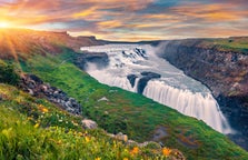
まず最初に訪れるのは二つの大きな滝です。
セリャランズフォス(Seljalandsfoss)は優美な姿が人気で、夏は裏見ができます。滝越しの景色は美しく、今にも妖精が出てきそうです。
スコゥガフォス(Skogafoss)は雷鳴のような音を立てて流れる滝で、近くに立つとそのパワーに圧倒されます。
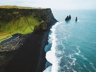
その後はヴィーク村の近くにあるレイニスフィヤラの黒砂海岸(Reynisfjara)をご紹介します。柱状節理の崖が見事で、夏はたくさんのパフィンが飛び交っています。
沖合にはレイニスドランガル(Reynisdrangar)という奇岩があります。誤って太陽の光を浴びて石になってしまったトロールの姿だと言い伝えられています。
バスの車窓からは、ソゥルヘイマヨークトル氷河(Solheimajokull)や2010年に大噴火したエイヤフィヤトラヨークトル氷河(Eyjafjallajökull)も見えるでしょう。
ツアーに使用するのは新しくてきれいなマイクロバス。車内では無料WiFiを使えるほか、ガイドがアイスランドの様々な物語や豆知識を披露します。アイスランドのおやつのサービスもあります!お昼には休憩をとりますので、各自昼食をお取りください。
アイスランド人に愛される南海岸の風景を見に行く日帰りツアー!カレンダーで日付を選択すると空き状況を確認できます。