비크의 검은 모래 해변에서 즐기는 스릴 넘치는 1시간 버기 투어


소개
요약
소개
비크(Vik)의 검은 모래 해변에서 즐기는 흥미진진한 버기 투어를 통해 아이슬란드의 검은 모래 해변의 아름다움을 가까이에서 경험해 보세요. 짜릿한 모험을 선사할 이 투어는 거친 지형에서 어드벤처 버기를 운전하는 스릴을 만끽하면서 아름다운 남부 아이슬란드 해안도 탐험하고 싶은 분들에게 안성맞춤입니다.
먼저 남부 아이슬란드의 비크로 이동하여 투어를 위한 체크인을 진행하세요. 이곳에서 기다리고 있던 현지 전문 가이드가 버기 운전에 대한 모든 세부 사항을 안내하고 철저한 안전 교육을 실시할 예정입니다.
버기는 안전하고 다루기 쉽지만, 버기를 직접 운전하려면 유효한 운전 면허증이 필요합니다. 버기를 한 번도 운전해 본 적이 없더라도 금방 조작법을 배울 수 있을 거예요. 투어 중에 착용할 작업복과 헬멧이 제공되므로 안전하게 주행을 즐길 수 있습니다.
출발할 준비가 되면 가이드가 전용 검은 모래 해변으로 안내해 드리므로, 이곳에서 방해받지 않고 멋진 경치와 짜릿한 모험을 즐길 수 있습니다. 이곳에서 버기를 타고 칠흑 같은 모래 위를 질주하며 속도감을 즐기고 아름다운 경치를 감상하는 특별한 시간을 만끽해 보세요!
각 버기에는 두 사람이 탈 수 있는 충분한 공간이 있기 때문에, 혼자 타거나 2인 1조로 타실 수 있습니다. 혼자 타면 한 시간 내내 버기를 운전할 수 있으며, 친구와 함께 타는 경우 번갈아 가며 운전할 수 있으므로 가끔은 아름다운 경치를 보다 편안하게 즐길 수 있습니다.
이 흥미진진한 투어는 6세 이상의 여행객 누구에게나 적합합니다. 다만, 어린이는 직접 버기를 운전할 수 없으며, 동승자로만 탑승이 가능합니다.
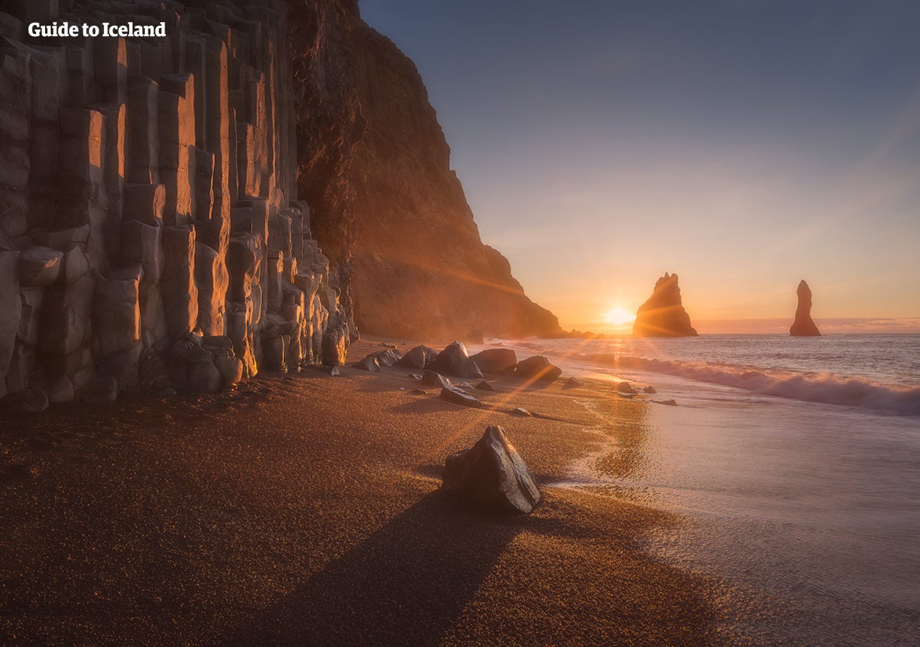
아이슬란드의 대부분의 해변에는 검은 모래가 깔려 있습니다. 이 투어에서 가까이서 볼 수 있는 이 모래는 화산 퇴적물로, 수천 년에 걸쳐 굳어진 용암과 현무암의 작은 입자예요. 이는 아이슬란드가 선사하는 매우 흥미로운 광경으로, 이 투어를 통해 이 독특한 풍경을 자세히 살펴볼 수 있습니다.
버기를 타고 주변의 아름다운 풍경을 감상하는 동안 가이드가 수 세대에 걸쳐 전해 내려오는 흥미로운 현지 민속을 비롯해 비크 지역에 대해 자세히 알려 드릴 거예요. 또한 사진 촬영도 해드리기 때문에 버기 투어를 통해 만든 특별한 추억을 오랫동안 간직하실 수 있습니다.
아이슬란드의 검은 모래 해변에서 버기를 타고 스릴 넘치는 모험을 즐기는 동안 시원한 바람을 온몸으로 느껴보세요! 지금 우측에서 원하는 날짜를 선택해 예약 가능 여부를 확인하실 수 있습니다.
포함 사항
액티비티
준비물
주의사항
본 투어는 2명이 버기 1대를 공유하는 것을 기준으로 합니다. 이 투어에 참여하려면 만 6세 이상이어야 합니다. 유효한 운전면허증을 소지한 사람만 버기를 운전할 수 있으므로, 운전면허가 없는 어린이 또는 성인은 동승자로만 탑승할 수 있습니다. 버기를 직접 운전하시려면 운전면허증을 반드시 지참하시기 바랍니다.
비슷한 투어


아이슬란드 최대의 여행 마켓플레이스를 전화에 다운로드하여 전체 여행을 한 곳에서 관리하세요
전화 카메라로 이 QR 코드를 스캔하고 표시되는 링크를 누르면 아이슬란드 최대의 여행 마켓플레이스를 주머니에 넣을 수 있답니다. 다운로드 링크가 포함된 SMS 또는 이메일을 받으려면 전화번호 또는 이메일 주소를 추가하세요.