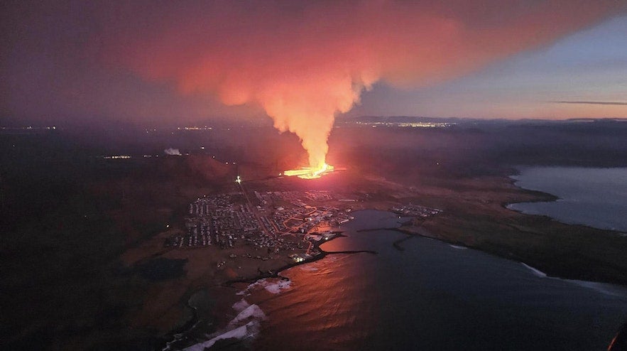
Since 2021, the area surrounding the town of Grindavik on the Reykjanes peninsula has been a hotspot for recurring volcanic activity. The initial 2021 eruption occurred at the nearby Fagradallsfjall volcano, which was followed by another eruption in 2022.
In the summer of 2023, the third eruption took place in the area, this time by the Litli-Hrutur mountain. Later that same year, Grindavik gained international attention when a fourth eruption was anticipated, this time much closer to the town.
Why You Can Trust Our Content
Guide to Iceland is the most trusted travel platform in Iceland, helping millions of visitors each year. All our content is written and reviewed by local experts who are deeply familiar with Iceland. You can count on us for accurate, up-to-date, and trustworthy travel advice.
Magma had started collecting under the nearby Svartsengi powerplant and the Blue Lagoon, and the earth trembled as a lava tunnel formed under Grindavik. Inhabitants were forced to evacuate as cracks formed throughout the town due to the seismic activity, damaging infrastructure. Thankfully, no one was harmed, and when an eruption finally started on December 18th, 2023, the town was deserted.
This eruption took place in the Sundhnukagigar crater row near the town, which had previously erupted over 2,500 years ago. It thankfully only lasted until December 21st and did not pose a direct risk to Grindavik or nearby infrastructure.
However, lava continued gathering under the earth, and just a month later, on the morning of January 14th, 2024, a volcanic fissure ripped open by Hagafell mountain, much closer to Grindavik. No lives were in danger as the town had been evacuated, but this eruption posed a far greater risk to the surrounding infrastructure, with lava reaching at least three houses on the outskirts of town.
The end of the Hagafell eruption was declared on January 19th, but it is only a part of a larger event in the area. Lava continues to gather underground, with more Sundhnukagigar eruptions taking place in the months afterwards.
There is still a risk of future eruptions in the area. While Grindavik reopened in October 2024, temporary evacuations have occurred since, and access to certain zones around the town remains restricted for safety. You can check the SafeTravel website for updates on the closure and check out our guide to the 2024 Hagafell volcanic eruption.
- Learn more: Guide to the 2024 and 2025 Sundhnukagigar Volcanic Eruptions
- See also: Guide to the 2023 Sundhnukagigar Volcanic Eruption
- Check out the 2023 Eruption of Litli-Hrutur Volcano
- See more: 2021 Eruption by Fagradalsfjall Volcano and 2022 Fagradalsfjall Volcano Eruption
The 2024 Eruption of Hagafell near Grindavik
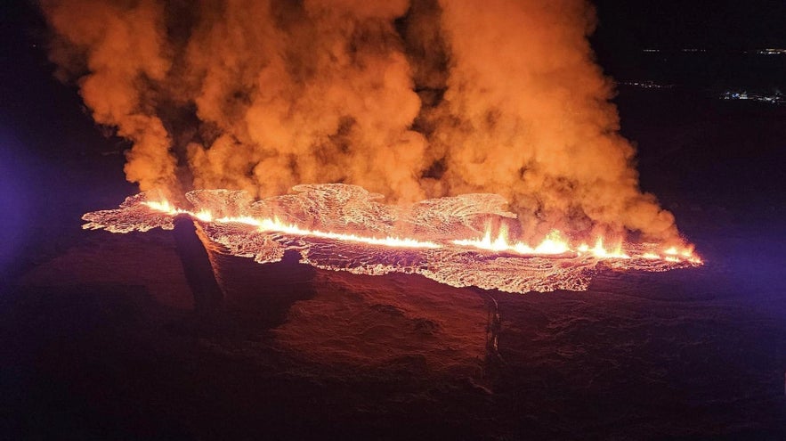
The Hagafell volcanic fissure went through the new protective barriers, but they still helped control most of the lava flow.
Since the December eruption of Sundhnukagigar, the town of Grindavik has been mostly deserted as it was considered unsafe to stay there for long periods of time. Work had begun on fixing deep cracks in the area and easing access, and the government had started evaluating the damage to houses, roads, and other infrastructure. Protective barriers were raised around the town and by the nearby Svartshengi and the Blue Lagoon in hopes that it would help control the lava flow of future eruptions.
By late December and early January, the inhabitants of the town were allowed to return to the area, though it was not recommended to stay there for long. However, in the early morning of January 14th, 2024, those who had returned to Grindavik were awoken by warning sirens and messages from authorities to evacuate.
Of the roughly 3,600 inhabitants, only around 200 were in the town that night, and they were able to leave quickly. The evacuation was due to a sudden, dramatic increase in seismic activity in the vicinity, indicating an impending volcanic eruption.
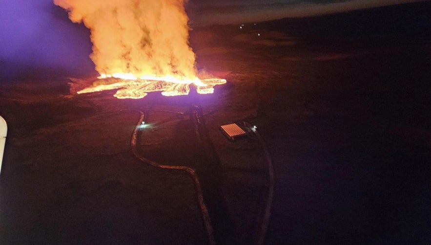 At 8 AM, five hours after the evacuation, the lava broke ground by the nearby Hagafell mountain, which lies at the edge of the Sundhnukagigar crater row and is just next to Grindavik. The first fissure was roughly half a mile (800 meters) in length, just north of the town but outside the new protective barriers. Thankfully, they did their job and helped steer the lava flow from the town, though it quickly reached the main road to Grindavik.
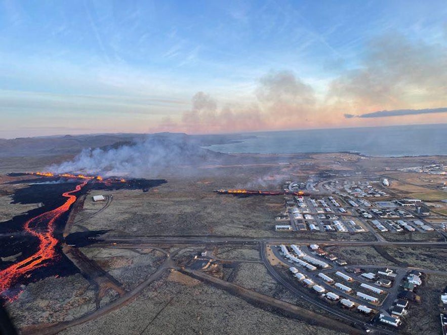
The situation escalated when a new fissure opened inside the protective barrier around 10 AM, just at the edge of Grindavik. Within the first few hours, the lava had started flowing into the town. Three houses were destroyed, but it currently seems that lava flow from this smaller fissure has stopped.
Activity in the Hagafell eruption slowly came to a stop over the next two days before it was officially declared to have ended on January 19th, 2024. More eruptions followed in 2025, including in January and July, leading to new evacuations due to smoke and gas. Lava damage was limited thanks to the barriers.
Lava accumulation beneath the Svartsengi power plant is a pressing concern, suggesting the likelihood of more eruptions soon. Additionally, the landscape is undergoing significant changes, with the ground expanding and shifting. This movement is creating deep and dangerous fissures, many of which are hidden from view on the surface, posing a hidden danger to the area.
It remains to be seen how the volcanic activity on the Reykjanes peninsula will develop in the coming months and years.
History of the Hagafell Mountain
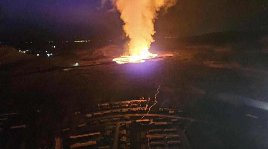
The Hagafell eruption as seen from a helicopter when it first started on January 14th, 2024.
The Hagafell mountain is just on the edge of Grindavik and has been a popular area for hiking. The area is crisscrossed with trails that offer lovely views of the town and the surrounding nature.
Hagafell is just next to the larger Thorbjorn mountain, which is an iconic landmark of the town. The top of Mt. Thorbjorn is characterized by a sharp ravine known as Þjófagjá or "Thieves' Ravine," which has a place in Grindavik's history. The ravine is said to have once been the hiding place of thieves who preyed on surrounding farms in the past. They were eventually caught, and the story goes that they were hanged by large cliffs in Mt. Hagafell, known as "gálgaklettar" or gallows cliffs.
Hagafell is surrounded by the old lava field that once ran from the Sundhnukagigar crater row over 2,500 years ago. The recent eruptions in 2023, 2024, and 2025 are reshaping this landscape, and it will take years for the new lava to cool down to safe temperatures.
The likelihood of further volcanic activity in the coming years may shape the area even further, though it's impossible to tell what will happen.


