

Beschreibung
Zusammenfassung
Beschreibung
Erlebe die Schönheit der isländischen Winterlandschaften auf dieser 9-tägigen Selbstfahrerreise über die Snaefellsnes-Halbinsel und entlang der Südküste – mit der Chance, die Nordlichter zu sehen. Dieses topbewertete Winterabenteuer ist ideal für alle, die Islands berühmte Sehenswürdigkeiten und versteckte Highlights in ihrem eigenen Tempo erkunden möchten.
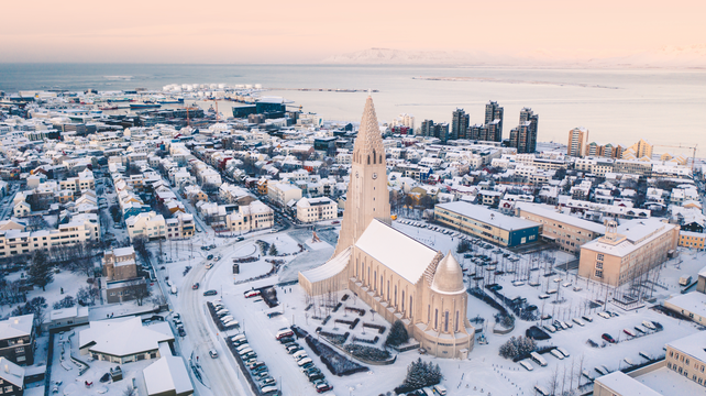
Deine Winter-Mietwagenreise beinhaltet einen Mietwagen, den du bequem am internationalen Flughafen Keflavík oder in Reykjavik abholen kannst. Das Fahrzeug ist perfekt auf Islands Straßenverhältnisse abgestimmt und verfügt über kostenloses WLAN, damit du unterwegs jederzeit verbunden bleibst, während du das Land aus Feuer und Eis entdeckst.
Diese Reise gibt dir maximale Flexibilität: Du entscheidest selbst, wann du aufbrichst und wohin du fahren möchtest. Du erhältst eine individuell ausgearbeitete Reiseroute, die von lokalen Experten sorgfältig erstellt wurde – mit tiefem Wissen über die winterlichen Bedingungen und Tageslichtzeiten in Island. So entfällt der Stress einer komplexen Reiseplanung. Alle Details können zudem an deine persönlichen Wünsche angepasst werden.
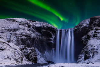
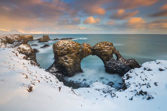
Du fährst entlang einiger der schönsten Routen in Island: dem weltberühmten Goldenen Kreis, den kontrastreichen Landschaften der Snaefellsnes-Halbinsel und den dramatischen Szenerien der Südküste. Zu den Höhepunkten gehören der Thingvellir-Nationalpark, Islands erstes UNESCO-Welterbe, der majestätische Snaefellsjökull-Gletscher sowie ikonische Naturwunder wie der Wasserfall Skogafoss und der schwarze Sandstrand Reynisfjara.
Mit neun gut geplanten Tagen hast du reichlich Zeit, die imposanten Gipfel, eisigen Gletscher und vulkanischen Küstenlinien zu genießen. Außerdem erkundest du den Vatnajökull-Nationalpark, Heimat des Vatnajökull-Gletschers – einer der größten Eiskappen Europas.
Zusätzlich kannst du einzigartige Aktivitäten zu deiner Reise hinzufügen, etwa Schnorcheln, Eishöhlenbesuche, Schneemobilfahren, Gletscherwanderungen oder einen Besuch der Blauen Lagune. Diese optionalen Touren werden von erfahrenen Guides geführt, die deine Sicherheit gewährleisten und dir helfen, das Beste aus jedem Erlebnis herauszuholen.
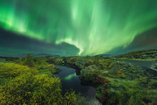
Im Winter hast du in Island besonders lange Nächte – perfekte Bedingungen, um die Nordlichter zu sehen. Wenn du außerhalb der Städte übernachtest, fern von künstlichem Licht, steigen deine Chancen erheblich, die farbenprächtigen Polarlichter am Himmel tanzen zu sehen.
Dieses Paket garantiert eine stressfreie Reise von der Ankunft bis zur Abreise. Dein Mietwagen und acht Übernachtungen sind vollständig organisiert, sodass du dich ganz auf dein Island-Abenteuer konzentrieren kannst.
Um deinen Komfort zu erhöhen, kannst du die Kategorie deiner Unterkünfte an dein Budget und deine Vorlieben anpassen. Ein persönlicher Reiseberater steht dir außerdem rund um die Uhr zur Verfügung, um Fragen zu beantworten und Unterstützung zu bieten.
Die Buchung ist völlig sorgenfrei: Sollten sich deine Pläne ändern, kannst du bis zu 24 Stunden vor Beginn der Reise kostenlos stornieren und erhältst eine vollständige Rückerstattung.
Diese Winter-Mietwagenreise macht das Erkunden Islands einfach und aufregend: Sie führt dich zu den beliebtesten Attraktionen sowie den schönsten Geheimtipps im Süden und Westen des Landes und umfasst zudem die besten Touren und Erlebnisse zu unschlagbaren Preisen.
Nutze die Gelegenheit und entdecke Islands Snaefellsnes-Halbinsel, die Südküste und die Nordlichter auf dieser beeindruckenden 9-tägigen Winter-Selbstfahrerreise. Prüfe jetzt die Verfügbarkeit, indem du dein Reisedatum auswählst.


