


Beschreibung
Zusammenfassung
Beschreibung
Begleite uns in eine der wildesten und schönsten Regionen Islands: das Thorsmörk-Tal im südlichen Hochland. Dies ist die perfekte Gelegenheit für Reisende, die Islands versteckte und unzugänglichsten Orte bei einem spannenden Superjeep-Ausflug ab Reykjavík erkunden möchten.
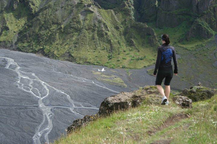
Thorsmörk ist zwischen Bergen und Gletschern eingebettet und seit Jahrhunderten unberührt. Das Tal ist nach dem nordischen Gott des Donners, Thor, benannt. Die Landschaft macht diesem Namen alle Ehre und präsentiert sich dramatisch: Sie umfasst eine Vielzahl von steilen Berghängen, gefrorenen Gletscherzungen, rauschenden Flüssen, Vulkanplateaus, üppigen Hügeln und dunklen, schroffen Höhlen. Es ist, als hätten die Götter selbst diesen Ort geformt.
Bei dieser Tagestour hast du die Möglichkeit, diese natürliche Oase zu erleben, die nur in den Sommermonaten zugänglich ist. Nur speziell entworfene Fahrzeuge, besser bekannt als Super-Jeeps, können den Weg durch die breiten Flüsse auf dem Weg hierhin wagen. Die Gegend ist besonders beliebt bei Naturliebhabern, Landschaftsfotografen und abenteuerlustigen Wanderern.
Bevor du in das grüne Herz von Thorsmörk eintauchst, macht der Superjeep zunächst einen Abstecher zum ikonischen Wasserfall Seljalandsfoss, einem der Schätze der isländischen Südküste. Seljalandsfoss ist ein seltenes Beispiel für einen Wasserfall in Island, bei dem es möglich ist, direkt hinter dem Wasserschleier zu laufen – was eine ganz neue Perspektive auf dieses erstaunliche Naturschauspiel bietet!
Der nächste Halt des Abenteuers ist die ständig wechselnde Gletscherzunge Gígjökull, die vom berühmt-berüchtigten Vulkan Eyjafjallajökull stammt. Beobachter des Zeitgeschehens werden diesen Vulkan als denjenigen wiedererkennen, der 2010 ausbrach und den Flugverkehr auf dem europäischen Festland stark beeinträchtigte. In der Gegend von Thorsmörk gibt es auch eine große natürliche Schlucht, in der man den Berghang betreten kann.
Warum also noch warten? Lass dir die Attraktionen in Thorsmörk, dem unglaublichen Tal von Thor, und an der wunderschönen Südküste nicht entgehen. Überprüfe die Verfügbarkeit, indem du ein Datum auswählst.


