
Tjörnin | The Pond in Reykjavik

- Learn more about Lakes in Iceland and Rivers in Iceland
- Why not jump on this Helicopter Ride & Glacier Hike from Reykjavik?
- Go further afield with this Katla Ice Cave Tour | Departure from Reykjavik
Tjörnin (The Pond) is one of the most popular recreational localities in Reykjavík, almost impossible to miss given its central location to downtown. Its surrounding area represents the very best of the capital’s character, radiating a delicate balance between authentic urban development and enchanting nature.
Though categorically a lake, the water body is referred to colloquially as a pond due to its extremely shallow depth. As for its title? The name Tjörnin is derived from the Old Norse 'tjörn', an ancestor of the Northern English 'tarn', meaning “mountain lake”.
The pond is also known by its longer title, Reykjavíkurtjörn (Reykjavík's Pond), though this is less widely heard across the city and does little to stimulate Google's search engine.

Referring to Tjörnin as a singular pond is rather deceptive; in fact, it is comprised of five different water bodies, stretching away from downtown toward Reykjavík's Domestic Airport which is built on the lake's source, Vatnsmýri Marsh.
These marshlands are well-regarded amongst the city's inhabitants as an excellent place to stroll, walk the dogs and get in touch with Reykjavík's surrounding nature.
According to the myth, two elderly ladies lived on opposite sides of the pond and regularly used to wash their clothes in the water. One day, while both were cleaning their stockings, an argument ensued as to who should have rights over all of the fish in the lake. In the heat of the moment, both ladies entered the water and, in a moment of magic, all of the fish turned to bugs and crustaceans. Ever since,, fishing has been off the agenda.
- See Also: Folklore in Iceland
 Still, such sorcery does little to deter the thousands of birdwatchers, photographers and nature enthusiasts who flock to the banks of Tjörnin every year to enjoy its colourful ambience.
But when did development around the pond begin? And what surprises can visitors expect when they arrive? All will be revealed as, together, we explore the fascinating history of Reykjavik's iconic water body, Lake Tjörnin.
The Formation of Tjörnin
To look at Tjörnin today, one could be forgiven for thinking it has always been a well kept and elegant feature, designed deliberately to complement the charming downtown ambience. After all, Tjörnin’s panorama is one of natural sophistication and aesthetic tradition; the colourful, Scandinavian lake-homes dot the eastern shore, creating a quintessential and charming fishing-village atmosphere right in Reykjavík's centre.
Alongside the ornate sculptures, distinguished buildings and the modern City Hall, it's easy to misjudge Tjörnin as beautiful but artificial. In actuality, the lake's roots go far deeper.

- See Also: History and Culture of Iceland.
Lake Tjörnin was first formed as far back as 800 AD when the water body became separated from the sea by a gravel barrier. The landscape of this period was starkly different to our own; amidst the heavy forest of ancient Iceland, the lake stretched far closer to the shoreline, its waters moving in current with the adjacent ocean tide.
To consider how it must have looked then—wild, untempered, at one with the primitive landscape—feels like a testament to the earliest settler's adaptability and affinity for cultivation.
According to medieval sources—in particular, The Book of Icelanders (Íslendingabók) and The Book of Settlement (Landnámabók)—Iceland was discovered by lost sailors, set off course while attempting to reach new colonies in the Faroes.
What they found was an uninhabited land perfectly suited for fishing, farming and stock-raising, with forests "from the ocean to the mountains." Considering the dark and cragged fields of the modern-day Reykjanes Peninsula, the reality of today's landscape is clearly quite different to the one found a thousand years ago.

The area around Lake Tjörnin was, most likely, first inhabited during the Age of Settlement, estimated between 870 AD - 930 AD. Though most Icelanders consider it little more than a pleasant and well-trodden story, it is collectively accepted that the Norwegian, Ingólfur Arnarson, was the first to settle here in 874 AD.
Ingólfur used the traditional Norse method of choosing a spot to settle, throwing two wooden high seat pillars (Öndvegissúlur) into the ocean and then following them to wherever they washed up on the shoreline. Nothing more of Reykjavik is mentioned in the medieval sources (save that it was covered in farmland,) but this story is still remembered in the design of the Reykjavík City Crest.
- See Also: The Icelandic Flag | A Tale of Identity
This story is only relevant in so much as the immediate area around Tjörnin was likely settled very quickly. After all, given the period, such a close water body would easily provide ample fertile land, during which time the flora would have changed dramatically from Birch and Willows to grass and marshland. This beginning of deforestation would come to have an enormous impact on the future of Iceland, both geographically and culturally.

It is also mentioned in the sagas that Iceland's earliest settlers—of which, after Ingólfur Arnarson, there were many—chose to build their farmsteads either on the coast or along coastal tracts leading inland. During this period, Tjörnin would have taken this very form, thus making it a desirable area in which to build or start a series of farmsteads.
Scientific evidence strengthens this theory; at the time of the settlement, the lake's dominant aquatic life form would have been Myriophyllum alterniflorum, though this deteriorated and finally disappeared in the 17th century, coinciding with a rise in the population of midges. All of this follows the trend of how a long-term human settlement affects the natural environment.
As with elsewhere on the island, soil erosion also generated a huge influence over the natural eco-system; around this time, sea levels were rising, the land was subsiding, and it is thought the water in the lake was brackish until the 12th century, then again in the 17th century.
As with all great natural features, Tjörnin has had many faces over the presiding centuries; only now does it lay domesticated and at one with the country's vision of civility and splendour.
The Modern History of Tjörnin
 Photo from Wikimedia, Creative Commons, by the Swedish National Heritage Board. No edits made.
The modern history of Tjörnin closely correlates to the history of Reykjavík; as the city's central feature, urban development was focused around the lake, though such development did not truly begin until the 18th century, following the introduction of wool and fabric workshops. These wool mills were to be the catalyst for Reykjavik's future development.
Introduced by “Sheriff” Skúli Magnússon, this successful attempt at modernising the economy came, quite literally, off the backs of sheep. The profits and high-quality derived from such workshops were dutifully noted by the Danish Crown, who in 1786, granted a permanent trade charter to the city.
The next decades saw enormous growth to Reykjavík—growth that would lead to the reestablishment of the Althingi (1844) and see power and governance return to Iceland's southwest.
- See Also: Where Do Icelanders Come From?
Two later economic surges aided Reykjavík's road to modernity; ironically, these surges came at the desperation, contention and downfall of many of the European colonial powers following the First and Second World Wars. During World War I, for instance, Icelandic wool was in high demand given the appalling state of mainland Europe and their agricultural industries.
The Second World War saw Iceland prosper again, though this time the government's involvement was, initially at least, reluctant and coerced. This was in stark contrast to the Icelandic people, many of whom readily welcomed the Allied forces as they approached the shore. Following the tactical British Invasion of Iceland—one could say a necessary deterrent to the Axis forces—the Icelanders provided fish to the Allies.
Soon, the British were gone and the Americans arrived, bringing with them a flurry of investment that saw the rapid construction of airports, factories, harbours and infrastructure. Almost overnight, it seemed, Iceland had stepped into the modern era.
 Photo from Wikimedia, Creative Commons, by Valgerður Tryggvadóttir. No edits made.
Tjörnin saw changes and development before, throughout and after both world wars. Tjörnin’s outlet is known as Lækurinn and was previously an open water channel that ran all the way from the pond to the ocean. In 1911, this stream was built over and made part of the sewer system beneath Lækjargata. The name Lækjargata, in fact, means "Stream Street."
1913 saw the introduction of locks on the lake’s outlet, preventing tidal surges from hitting Tjörnin (in 1989, all sea water was prevented from entering the lake, and thus its transition to a freshwater body quickly took form).
In 1920, a pedestrian bridge was built across the pond, thus splitting the water body into two; North Tjörn and South Tjörn. Numerous improvements were made to the bridge throughout the war years, the biggest occurring in 1942 when the lane was widened and concreted over to accommodate motorised traffic. The bridge is colloquially referred to as "The Bridge Across the Pond. "
Environmental Impact

Such rapid changes have obviously had an impact on the ecosystem of and surrounding Tjörnin. Until the 1920s, the southern end of the lake was utilised as a rubbish dump by the City of Reykjavik. All roads and buildings seen adjacent to the lake have been constructed over the location of these historical landfills, and the embankments of the lake have since been restructured, thus classified as 'man-made.' Estimates suggest that up to 30% of the lake has been lost to these landfills.
Today, a large cut of Tjörnin's watershed is taken up by Reykjavik Domestic Airport. The surrounding wetlands have also been drained. In the last twenty years, the University of Iceland has also extended its campus into the wetlands' eastern section and the road Hringbraut now stretches further into the area than it once did. Though a short distance away from the lake, the use of fertilisers in the area has increased the water's nutrient count.
What to See and Do at Tjörnin
Birdwatching at Tjörnin
 Photo from Wikimedia, Creative Commons, by Adrian Simmons. No edits made.
Avid bird watchers, wildlife enthusiasts and ornithologists will find Tjörnin teeming with over forty different bird species including Arctic Tern, Eider Ducks, Gadwalls. Greylag Geese, Seagulls, Scaup and Mallard Ducks. Quite often, one will also see Whooper Swans crowding together on the pond surface.
The Gadwall, the Eider and Scaups are all migratory birds; the Eider spends the winter months at sea whilst Gadwalls and Scaups seek a more temperate climate in mainland Europe. The lake is an important moulting site for Mallards in particular; at the height of summer, up to 500 male Mallards will culminate on the lake to shed their flight feathers.
Birdwatching as a pastime here is, in fact, one of Reykjavík’s simplest and most satisfying pleasures, attracting twitchers from all around the planet, eager to tick some of the species off of their list. Tjörnin was in fact designed to attract bird life to the centre of the city, and future plans as to how to manage the lake always take into consideration how to preserve this wild diversity.
- See Also: Wildlife and Animals in Iceland
Feeding the birds at Tjörnin is a popular pastime for families, so popular in fact that the pond is often referred to in Icelandic as “stærsta brauðsúpa í heimi” (“The biggest bread soup in the world.”)
Despite the seemingly innocent nature of feeding birds at the pond, biologists such as Þóra Hrafnsdóttir recommend that visitors avoid giving them bread and instead opt for grains and seeds. Not only is bread bad for the birds’ diet, it also attracts predatory birds and creates toxins in the water.
The relationship between the pond’s birdlife and human beings has not always been so symbiotic. Throughout the centuries of settlement, hunting geese and ducks and poaching their eggs was a common practise. However, in 1919, all hunting in the area was banned. Very quickly, the species numbers began to recover, culminating in the rich and diverse ecosystem we see today.
 Photo from Wikimedia, Creative of Commons, by Andreas Tilles. No edits made.
Today, far more effort is made towards conservation efforts and protecting the pond’s wildlife. Given their aggressive nature, residents often take it upon themselves to clear the seagull nests from the area, a preventative measure to stop the seagulls hunting baby ducklings in the spring and summer.
This is one of the primary reasons as to why visitors to Tjörnin have been asked by Reykjavík City Council to refrain from feeding the birds from May to August, as the bread attracts a large number of seagulls.
There is a good reason for Reykjavík's residents to worry about the well-being of Tjörnin; in 2011, it was found that aggressive flora such as thistle and chervil had made the lake unsuitable for nesting birds, and thus, the summer saw a far lower density of young wildlife. Plans were since conceived of by a number of bodies, including the University of Iceland, Reykjavík City Council and Nordic House, to improve the lake's condition by introducing appropriate wet-vegetation.
Ice Skating at Tjörnin
During the winter months, Tjörnin freezes over to create a gorgeous, glittering ice sheet in the centre of town. Quick to maximise the opportunity, Icelanders have been ice skating on Tjörnin ever since they could, creating a winter tradition that grows in popularity each year. The Reykjavík Ice Skating Association was formed on Tjörnin in 1892.
Ice skating on Tjörnin is as safe as the pastime can be; the pond is very shallow with an average depth of 57cm (1.9 feet), its deepest point measuring 80cm (2.4 feet). Still, with sub-zero temperatures affecting the city, the ice has no means of breaking under human weight, creating a secure and fun public ice rink suitable for the entire family (with that being said, the ice did break in 2009 whilst hosting a horse parade; thankfully, nobody was injured.)
When the pond freezes over, local junior colleges will often play football matches on the ice. In recent years, the Reykjavík grammar school, Menntaskólinn í Reykjavík (MR) and the Women's Academy, Kvennaskólinn, have played friendly matches against one another on the ice.
Culture & Buildings Around Tjörnin
 Photo from Wikimedia, Creative Commons, by Helgi Halldórsson. No edits made.
Tjörnin has inspired an eclectic wealth of artistic endeavour, ranging from prized and historic sculptures to modern electro-pop music. This shouldn’t come as a surprising discovery given the pond’s central location to downtown; in close proximity, one can stumble across museums, theatres, inner-city parks, traditional residential neighbourhoods and iconic cultural landmarks.
- See Also: Art Galleries in Reykjavik
At the southeast foot of the pond can be found Hljómskálagarður Park, a green area intercut with trees and footpaths well frequented by the city’s joggers and cyclists. The idea for a park at the end of the lake was first proposed at the end of the 19th century, but it wasn't until 1901 when the city council finally set land aside for development.
Designs for the green space were submitted by Knud Ziemsen (later mayor) and the architect, Frederik Kiørboe, in 1908. In 1914, 400 birch saplings were planted in the west and south of the park.
The park has an entire section dedicated to five female Icelandic sculptors; Gerður Helgadóttir, Ólöf Pálsdóttir, Þorbjörg Pálsdóttir, Gunnfríður Jónsdóttir and Nína Sæmundson.
This section of the park was opened in 2014 at a cost of an estimated 13 million ISK; the project is seen as a collaboration between the public, the city planners and Reykjavik Art Museum. The sculpture garden is known as Perlufestin, or "The Pearl Necklace", a reference to how each piece is unique and yet still connected by its location.
Nína Sæmundson’s ‘Mermaid’ sculpture, sits within the pond, its 2014 unveiling being the last act by outgoing Reykjavík mayor and comedian, Jon Gnarr. Originally, another depiction of the stony siren sat in the lake from 1966.
However, a New Year's Eve explosion destroyed the statue, with many considering the reason being its resemblance to the Edvard Eriksen’s sculpture of the Little Mermaid in Copenhagen. Given Denmark's colonial history over Iceland, this original statue placement was likely to have rubbed many of Reykjavík's inhabitants up the wrong way.
Aside from the beautiful sculptures and pleasant gardens, it is the architecture surrounding Lake Tjörnin that immediately strikes a nerve. Given the pond's centrality, some of the nearby buildings include Reykjavík Art Museum, the Supreme Court of Iceland, the Living Art Museum, the Parliament Building, the Independent Theatre Tjarnarbíó and the event venue space, café and restaurant Iðnó.
 Photo from Wikimedia, Creative Commons, by Helgi Hall. No edits made.
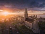
Fríkirkjan í Reykjavík ("The Free Church of Reykjavík") is an instantly recognisable feature along the banks of Lake Tjörnin, its green rooftop an enigma against the traditional, red-roofed churches across the country.
The church is truly a historical landmark; consecrated in 1903, the church's initial membership totalled 600, rising quickly over the proceeding years. The Free Church congregation was established just at the end of the 19th century, in the Autumn of 1899.
The church was erected not due to any doctrinal contention with the National Lutherans, but rather because of problems that certain community members had with the organisation itself. The Free Church closely aligned itself with houses of worship in Norway and of those established by Icelandic immigrants to North America; hoping to bring the church and community closer, the Free Church was considered something of a grassroots alternative to Reykjavík Cathedral.
In that light, Fríkirkjan í Reykjavík was the church of the proletariat, the fishermen, the craftsman, the farmers and their families.
Alongside the pond's western side, on the road Fríkirkjuvegur, one can find the instantly recognisable building, The National Gallery of Iceland. To look at, it almost defies imagination that the building was originally constructed as a freezing plant, used to store ice sculpted from the frozen surface of Tjörnin.
In the winters of 1919 and 1920, over 11,000 cubic metres of ice was uplifted from the lake, transferred to the freezing plants by sleighs to, eventually, be used for fish packing on trade missions to Britain.
The plant was erected in 1916 and designed by the famous Icelandic architect, Guðjón Samúelsson. Guðjón Samúelsson's work can be seen throughout downtown Reykjavík. One could, in fact, take your own "Guðjón Samúelsson tour", checking out the enormous impact this one man had over the aesthetic traditions of this northern capital.
Having played a key role in the city's urban planning, one can see Guðjón's finished work in the National Theatre of Iceland, the Landakot Catholic Cathedral, Hallgrímskirkja and the Church of Akureyri. He was also the principal architect of the University of Iceland, a building that the British Commander refused to commandeer on account of it being "too beautiful" during the UK's WWII invasion of the country.
 Photo from Wikimedia, Creative Commons, by Diego Delso. No edits made.
Tjörnin has also appeared numerous times in other media and artistic outlets. In regards to literature, the lake plays a prominent role in Geoffrey Gates' 2015 "The Copycat Murders" and Steinar Bragi's book, "The Ice Lands", amongst many others, and is also one of the settings in the 2010 Icelandic film, "Gauragangur", a comedy directed by Gunnar B. Gudmundsson. Aside from that, one can find a wealth of painting and photography focused on Tjörnin as its subject.
- See Also: The Story of Icelandic Cinema
To explore the lake's influence over musical artists, we must return for a moment to Hljómskálagarður Park. The name of park literally translates to "Music Pavillion Park", a testament to Hljómskálinn, a pavilion that was constructed in 1923 and lies just east of the bridge, Skothúsvegur.
The pavilion was the first building in Iceland deliberately built as a venue for musical performance. The designers set about creating an area where Iceland's brass musicians could play on clear and sunny days. From 1922 to 1924, Reykjavik's first music school operated from the pavilion and in 1930, the venue was chosen as the place to found the Reykjavik Music College.
One latest addition to the scene that has used Lake Tjörnin as a creative influence is the below track by Icelandic supergroup, Uniimog, a band made up of talented and already-successful musicians, including singer-songwriter Ásgeir Trausti.
- See Also: The Return of Ásgeir
Reykjavik City Hall
Reykjavík City Hall is home to the offices of the city’s officials—including the current Mayor, Dagur Bergþóruson Eggertsson—as well as a large 3D topographical map of Iceland that clearly displays the country’s many volcanos, lakes, glaciers and mountain ranges.

The building is renown for its modern architecture, a culmination of concrete, large glass windows and dramatic columns that make it appear as though the building is floating peacefully atop the pond. Reykjavík City Hall is often also utilised as a music venue or an exhibition space.
The building was constructed in 1992 following a design competition won by the Reykjavík-based architecture practise, Studio Granda. Founded by married couple Margrét Harðardóttir and Steve Christer in 1987, Studio Granda’s philosophy has always been rooted in using traditional Icelandic materials—stone, sheet metal NS timber—that could be categorised as Nordic modernism.

The studio is responsible for a number of iconic buildings in the city, including the Supreme Court of Iceland and Reykjavík Art Museum. Since January 2017, Reykjavík City Hall has also housed Guide To Iceland, the city’s official tourism provider. Travellers are free to drop in to find out further information about tours, itineraries, accommodation and car rentals.
Visiting Guide to Iceland at Reykjavík City Hall is one of the simplest methods of purchasing a Reykjavík City Card, a passport that allows you to explore the capital’s museums and galleries without breaking the bank.
- Purchase yours here: Reykjavik City Card | Reykjavik in Depth
Reykjavík City Card holders are also able to access the city’s public transportation system and are offered excellent discounts in numerous shops and restaurants.
Make sure you stop by and say hello on your visit to Tjörnin! Reykjavík City Hall is open every day, all year round, from 8.00 to 20.00.
Written by Mike Chapman


Inne interesujące artykuły

Wycieczka rodzinna do Reykjaviku | Z dziećmi na Islandię
Czy planujesz rodzinne wakacje na Islandii ? Dowiedz się, co warto robić i zobaczyć, będąc w Reykjaviku i okolicach z dziećmi! Sprawdź wycieczki rodzinne po Islandii Znajdź samochód do wynajęcia n...Czytaj więcej13 najlepszych tanich rzeczy do zrobienia w Reykjaviku
Poznaj najlepsze darmowe i tanie atrakcje w Reykjaviku oraz dowiedz się, co robić wieczorem. Pełne życia ulice i dynamiczna kultura otoczone wspaniałymi krajobrazami charakteryzują najbardziej wysu...Czytaj więcejTop 10 rzeczy do zrobienia w Reykjaviku
Przeczytaj o najlepszych rzeczach do zrobienia w Reykjaviku, stolicy Islandii. Reykjavik oferuje nieskończone możliwości spędzania czasu, od tętniącej życiem sceny artystycznej i muzycznej po skarbn...Czytaj więcej


Pobierz największą platformę turystyczną na Islandii na telefon i zarządzaj wszystkimi elementami swojej podróży w jednym miejscu
Zeskanuj ten kod QR za pomocą aparatu w telefonie i naciśnij wyświetlony link, aby uzyskać dostęp do największej platformy turystycznej na Islandii. Wprowadź swój numer telefonu lub adres e-mail, aby otrzymać wiadomość SMS lub e-mail z linkiem do pobrania.


