Limited availability
Reserve early to save money
Best price guaranteed
No booking fees
Ice Cave Day Tour with Flights from Reykjavik
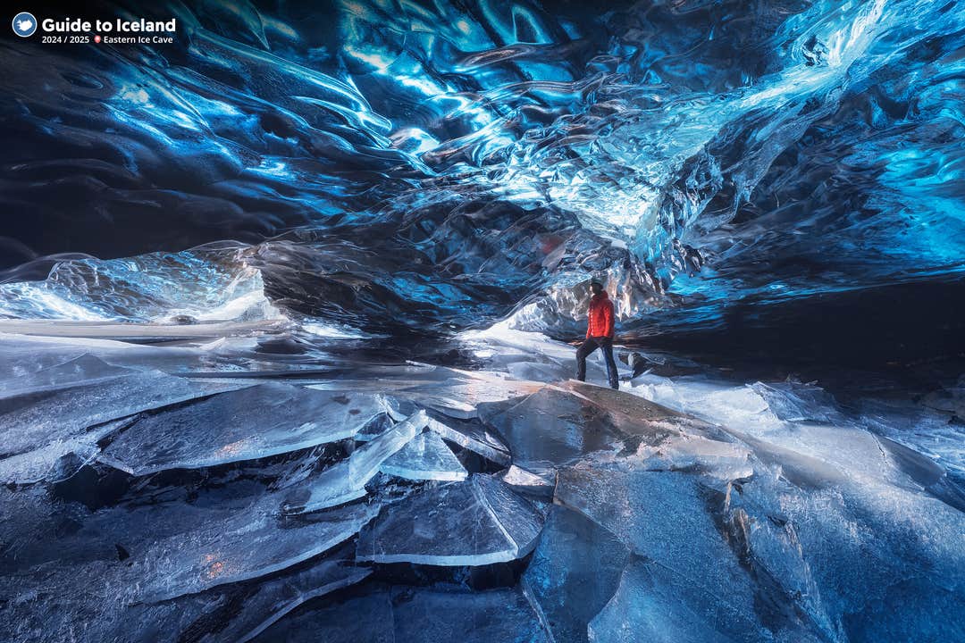
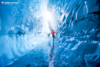
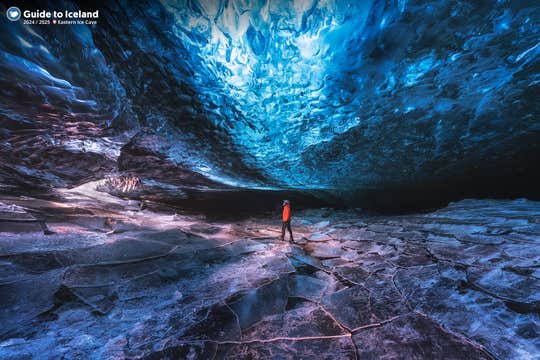
Hop on a plane for a scenic flight over the South Coast of Iceland and then explore a natural ice cave. This tour is for everyone who wants to see something truly rare: the world inside a glacier.
Every year, stunning ice caves are formed by running water from Europe's largest glacier, Vatnajökull. Each cave collapses during summertime and gets filled with water, and each winter new ones form. Therefore, every single cave is unique, and you won't have the same experience twice when you go to see a natural glacier cave.
Vatnajökull is situated in the south-east of Iceland, about a 6-hour drive one-way from Reykjavík. To drive there and back, you would thus need at least 2 days. Flying, however, gives you the chance to visit the ice caves, the nearby glacier lagoon Jökulsárlón and the Diamond Beach all at once, without rush.
The flight departs from Reykjavík airport at 8:55 AM, and in just 50 minutes, you will have reached Höfn in East Iceland. Your return flight to Reykjavík is at 6:55 PM.
Jökulsárlón glacier lagoon is right by the glacier and connected to the sea. In it, you will see majestic icebergs afloat, and you may even spot some seals relaxing on the ice. Where the lagoon meets the sea, there's a Diamond Beach, named for the glistening ice scattered along it.
The flight itself will be in a small plane and will provide spectacular aerial views of the Icelandic coastline. On a clear day, you'll get a great view of Vatnajökull glacier itself, giving you an idea of its immense size.
The ice caves should not be missed if you are here during winter and if you're pressed for time, this is the perfect tour for you. As soon as you reserve it, we will contact you to send you your flight tickets and provide you with all the necessary information.
Come aboard for the experience of a lifetime. Check availability by choosing a date.
Quick facts
- Available: Nov. - Mar.
- Duration: 12 hours
- Activities: Glacier Hiking, Super Jeep, Sightseeing, Airplane
- Difficulty: Easy
- Minimum age: 8 years.
- Languages: English
- Highlights: South Iceland,
South Iceland is the most popular part of the country amongst travellers and contains some of Iceland’s most beautiful natural attractions.
Amongst these are the sites of the world famous Golden Circle, and the features of the South Coast, such as the beautiful Jökulsárlón glacier lagoon.
The south of Iceland can be roughly split into two areas, the lowlands in the west, and the east.
The South Icelandic lowlands
The South Icelandic lowlands stretch nearly 100 kilometres (over sixty miles) from Hellisheiði in the west to Eyjafjallajökull in the east. This region is flat and fertile farming land, and home to many Icelandic horses and sheep.
The whole area is geologically very young, formed during the last Ice Age by the lava flows from numerous volcanoes in the area. The lowlands are surrounded by volcanically active mountains, notably the aforementioned Eyjafjallajökull and Hekla.
The most notable features of the South Icelandic lowlands are the three on the Golden Circle, the country’s most popular sightseeing route.
These consist of the Geysir Geothermal Area, where geysers erupt and hot springs bubble, Gullfoss, a powerful two-stepped waterfall, and Þingvellir National Park, an oasis of forests and lava located between the tectonic plates.
The fissures and lava landscapes of this latter feature reveal the extent to which earthquakes and eruptions have shaped the region. The area is still very active; take, for example, the 1975 eruption in the Westman Islands that nearly destroyed the town and formed a new island.
It should be noted that Þingvellir is not just a site of natural, geological wonder. It was also the original site of the parliament Icelanders formed in 930 AD. This was a convenient place, considering the fertile lands of south Iceland meant that many settlers populated it.
Unlike most early Icelandic settlements, few of the communities formed in the south were based off fishing. The only town with a significant harbour in the south is Þorlákshöfn, where the ferry to the Westman Islands leaves.
Other towns in the lowlands are Selfoss, Hveragerði, Hella and Hvolsvöllur, all conveniently located by the Ring Road.
In terms of culture in the lowlands, it was once home to the ancient bishop seat of Skálholt. Also, Iceland's most famous saga, Njal's Saga, takes place in the region.
For sports, horse riding is popular, as is fishing for salmon and trout, hiking, snorkelling, sightseeing and river rafting.
Eastern South Iceland.
The areas south and east of Mýrdalsjökull, the glacier that covers the volcano Katla, are considered the eastern part of south Iceland. Glaciers, volcanoes and the Highlands dominate the view.
This landscape has also been shaped by volcanic eruptions, although these were much more recent, and thus the area looks dramatically different. Vast expanses of black sand stretch from the Highlands to the sea, part of several glacial outwash plains that flood during a volcanic eruption.
Some agriculture is found here, with farms nestled in the mountains, but because of the glacial floods, they are few and far between.
A few large glacial rivers flow through this area, creating incredible features such as Skógafoss and Seljalandsfoss. These are hardly the only sites in this part of the south worth seeing, however.
Sólheimajokull is a beautiful outlet glacier, a tongue of the greater Mýrdalsjökull, that you can hike on so long as you are with a guide. Skógar has a very interesting museum that discusses national traditions during Iceland’s development. One of Iceland’s most famous hiking routes, Fímmvörðuháls, cuts through the area.
Southwest of the village of Vík is one of Iceland’s most spectacular beaches, Reynisfjara. Near the promontory of Dýrholaey, and boasting incredible views of the Reynisdrangar sea stacks, it is a marvellous stretch of black sand.
Even further east is the Skaftafell preservation area, an area so beautiful it was once a national park in its own right. Today it is part of the greater Vatnajökull National Park, which covers parts of the south, east, north and much of the Highlands.
Just a little further from here is the incredible, world famous Jökulsárlón glacier lagoon, a deep lake that fills with icebergs. At the adjacent Diamond Beach, they wash upon the shore.
Jökulsárlón,Jökulsárlón is Iceland’s most famous glacier lagoon. Conveniently located in the southeast by Route 1, about halfway between the Skaftafell Nature Reserve and Höfn, it is a popular stop for those travelling along the South Coast or around the Ring Road of the country.
Geography
As a glacier lagoon, Jökulsárlón is a lake that is filled with the meltwater from an outlet glacier. In this case, it is Breiðamerkurjökull, a tongue of Europe’s largest ice cap, Vatnajökull.
It stands out, however, due to the fact that it also fills with icebergs breaking from the glacier, some of which tower several stories high.
These icebergs, other than their scale, are notable for their colouration. Although they are, as expected, largely white, most are also dyed electric blue in part, with black streaks of ash from eruptions centuries past.
When the icebergs finally make it across the lagoon, they either drift out to sea or wash up on the nearby shore. Because of the way they glisten against the black sands of Breiðamerkursandur, this area has been nicknamed ‘the Diamond Beach’.
In spite of being a rather recent formation, Jökulsárlón is the deepest lake in the country, with depths of 248 metres (814 feet). With a surface area of 18 square kilometres (7 square miles), it is also growing to be one of the largest.
History
Jökulsárlón has not been around since Iceland’s settlement; it only formed around 1935. This was due to rapidly rising temperatures in the country from the turn of the twentieth century; since 1920, Breiðamerkurjökull has been shrinking at a dramatic rate, and the lagoon has begun to fill its space.
Today, the expansion of Jökulsárlón is accelerating. In 1975, it had less than half its current surface area.
In the relatively near future, it is expected that the lagoon will continue to grow until it becomes a large, deep fjord.
Though a dark omen for Iceland’s glaciers and ice caps in general, the retreat of Breiðamerkurjökull has resulted in an incredibly beautiful, if temporary, site. This has not been overlooked by Hollywood.
Jökulsárlón has been featured in the James Bond films A View to Kill in 1985 and Die Another Day in 2002, 2001’s Lara Croft: Tomb Raider, and 2005’s Batman Begins.
In 2017, Jökulsárlón was enveloped into the Vatnajökull National Park, thus it is now fully protected by Icelandic law.
Wildlife
Because of the wealth of herring and capelin that the tides bring into the lagoon, Jökulsárlón is somewhat of a hot-spot for Iceland’s wildlife.
In summer, it is a nesting site for Arctic Terns; stay well away from their nesting area, as these birds are notorious for the fierceness with which they protect their eggs, dive-bombing the heads of any they see as a threat. Skuas also nest on the lake’s shores in this season.
Seals can be reliably spotted here throughout the year, swimming amongst or else hauling out on the icebergs. Jökulsárlón provides them with a safe haven to rest and socialise, especially considering the waters of southeast Iceland are renowned for their population of orcas.
Vatnajökull,Vatnajökull glacier is the largest glacier in Europe, covering 8% of Iceland’s landmass.
It is the central feature of the Vatnajökull National park, found in the south west of Iceland, a popular spot for activities like glacier hiking from Skaftafell, boat tours in the Jökulsárlón glacier lagoon, and ice caving tours between November and March.
Facts about Vatnajokull
Vatnajökull has a surface area of approximately 8,100 square kilometres (3127 square miles); though it is rapidly shrinking due to climate change, its recession is not quite as advanced as at other glaciers, such as Langjökull and Mýrdalsjökull. In parts, it is a kilometre deep (over three thousand feet), and its average thickness is around half of that.
Vatnajökull also holds the tallest peak in Iceland beneath its ice; Hvannadalshnjúkur is 2,200 metres tall (7,218 feet). It also conceals some of the most active volcanoes in the country, the most notable being Grímsvötn, Öræfajökull and Bárðarbunga.
Volcanic activity in the region has occurred on and off throughout the centuries, and many geologists believe that several eruptions are overdue. If their calculations are correct, it would mean significant volcanic activity for Vatnajökull over the scope of the next half-century.
Depending on winds, this could result in worldwide consequences in terms of air-travel, agriculture and the general climate.
The glacier boasts over 30 outlet glaciers, which are channels of ice that flow out of ice caps but remain constrained on the sides of the valley. The major outlet glaciers of Vatnajökull include Dyngjujökull in the north, Breiðamerkurjökull, and Skeiðarárjökull to the south. To the west, one can find the outlet glaciers Síðujökull, Skaftárjökull and Tungnaárjökull.
Numerous rivers run out of Vatnajökull, making up some of the greatest glacial rivers in Iceland. The most notable are:
Tungnaá (west)
Köldukvísl (west)
Þjórsá (west)
Jökulsá á Fjöllum (north)
Skjálfandafljót (north)
Jökulsá á Brú (northeast)
Jökulsá í Fljótsdal (northeast)
Jökulsá í Lóni (south)
Hornafjarðarfljót (south)
Jökulsá á Breiðamerkursandi (south)
Skeiðará (south)
Núpsvötn (south)
Hverfisfljót (south)
Skaftá (south)
Vatnajokull National Park
Vatnajökull National Park was established in June 2008 and has slowly grown to include more and more areas. The park now covers an area of 14,141 square kilometres (5,460 square miles), 14% of the country. It is the second largest national park in Europe.
Rivers divide the highland plateau to the north of the park. The volcanic table mountain Herðubreið towers over this particular region, along with volcanoes Askja, Snæfell and Kverkfjöll.
The canyon Jökulsárgljúfur was carved out by glacial floods centuries ago. At the upper end of the canyon, you'll find Dettifoss, the most powerful waterfall in Europe. Further north, the horseshoe-shaped canyon Ásbyrgi is believed to have formed when Óðinn's eight-legged horse, Sleipnir, stepped his foot down from the heavens.
East around Snæfell, one can find wetlands and ranges, home to roaming herds of wild reindeer and abundant birdlife. Steep mountain ridges make up the south side of Vatnajökull, where outlet glaciers crawl onto the lowlands. The sandy plains of Skeiðarársandur also lie to the south, and the glacial river Skeiðará runs through this vast desert.
One of Iceland's most visited landmarks in the National Park is the Jökulsárlón glacier lagoon, which sits at the base of the outlet glacier Breiðamerkurjökull. Here, large icebergs that have broken off the glacier float across a vast lake before ending up in the Atlantic Ocean, or washed ashore on the nearby Diamond Beach.
This is one of the best seal-watching spots in the country.
The Future of Vatnajokull
The volume of Vatnajökull reached its peak around 1930 but has since been in a steady process of decline. Because of rising levels of global temperature, Vatnajökull has on average lost about a metre (three feet) of its thickness annually over the past 15 years.
If temperature levels continue to rise, the glacier could be all but gone nearing the end of the next century, leaving only small ice caps on top of the highest mountain summits.
Efforts are being made to prevent what some say is the inevitable, with reforestation projects going on all around the glacier, a proven method of cooling the area. Time will tell how successful they are.
Vatnajokull and Jokulsarlon in Popular Culture
The beauty of Vatnajökull National Park has not gone unnoticed by those in film or television. Many famous scenes have been shot here, starting with James Bond: A View to Kill in 1985. Other notable films with scenes here include Batman Begins, Lara Croft: Tomb Raider, and James Bond: Die Another Day.
Most famously, however, many places in Vatnajökull have been used in the HBO Series Game of Thrones, north of the Wall. The Wall itself is constructed with CGI using shots of the glacier.
Skaftafell,Skaftafell is a nature reserve located in Vatnajökull National Park in the south-east of Iceland. It is an oasis of this nation’s diverse landscapes and features, so beautiful it was once a national park in its own right.
Nature of Skaftafell
Skaftafell is notable for its rich flora, growing between sands and glaciers, and for its amazing, contrasting scenery. Visitors will find a wealth of natural attractions, from cascading waterfalls to glacier lagoons, geological formations to black sand deserts.
The rugged region is known for its fantastic photo opportunities, with many awe-inspiring panoramic views.
Like many areas along the South Coast of Iceland, Skaftafell Nature Reserve is known for its glorious hiking trails, often called a ‘hiking paradise’. Unlike in the Highlands, where hikes tend to go on for multiple days, here there are far shorter. There are easy treks that lead to diverse sites such as the waterfall Svartifoss which is surrounded by bizarre and beautiful basalt columns, as well as to glaciers such as Svínafellsjökull.
With a qualified guide, it is an excellent region to try your hand at a spot of either ice climbing or glacier hiking; both activities are two of the most authentically Icelandic experiences you can partake in whilst in the country.
The nature reserve is also the perfect base camp for those seeking to climb Iceland’s highest peak, Hvannadalshnúkur, or for those wishing to spend a number of days exploring the region's attractions, including Vatnajökull glacier, Jökulsárlón glacial lagoon and the nearby Diamond Beach.
Getting to Skaftafell
Just off the Ring Road in the south-east of the country, it takes approximately four hours to reach Skaftafell from Reykjavík. The South Coast, however, is one of the regions most popular sightseeing routes, so the journey usually takes much longer, as visitors will want to make several stops along the way.
Examples of the beautiful natural features found en route to Skaftafell include the waterfalls Seljalandsfoss and Skógafoss, the glaciers Mýrdalsjökull and Eyjafjallajökull, the black sand deserts of Sólheimasandur and Skeiðarársandur, as well as the dramatic coastal rock formations at Dyrhólaey and Reynisdrangar. The villages of Vík and Kirkjubæjarklaustur are also along Route 1 if you need to stop and refuel on refreshments.
Those who have made it all the way to Skaftafell will want be sure to check out the Jökulsárlón glacier lagoon, a giant lake filled with enormous icebergs breaking from a glacial tongue, and slowly drifting to sea. At the nearby Diamond Beach you can watch them wash upon the shore, and in both the sea and lagoon are many seals which can routinely be spotted.
Skaftafell Visitor Center
You will find a Visitors Centre at Skaftafell which acts as the main information and meeting point for tour operators and independent travellers. At the Skaftafell Visitor Centre, you will find answers to virtually any questions you might have about the greater Skaftafell area, including its history and geology. The Visitors Centre also contains information about nearby hiking trails, recreational options and accommodation.
There is also a hotel at Skaftafell, though it tends to book up very early. Luckily, the south-east is dotted with hotels, cabins and cottages in which you can stay, and the area is not far from the settlements of Höfn or Kirkjubæklaustur.
Höfn,Höfn is an Icelandic fishing town of just over two thousand people in southeast Iceland. It is the most significant settlement on Route 1 between the village of Kirkjubæjarklaustur in the south and Egilsstaðir in the east.
Geography of Höfn
Höfn means ‘harbour,’ as the town is located in one of the few natural harbours of Iceland’s South Coast; unlike the rest of the country, this stretch is beachy and flat, and thus there are hardly any small coastal villages when compared to places such as the Snæfellsnes Peninsula.
The town is right at the tip of its own peninsula, which is easy to reach throughout the year. It sits at the base of Route 99, which detours off from Route 1. It is surrounded on three sides by the ocean, which has been known to freeze over in extreme conditions.
The town can also be reached by plane in good weather, as it is one of the few locations in the country with a domestic airport.
The largest glacier in Europe, Vatnajökull, which sits in a National Park of the same name, is within clear view of Höfn.
Nearby Locations to Höfn
Höfn is most often visited by those driving the full Ring Road of Iceland, as a place to stay just before or after visiting the South Coast or East Fjords.
It is also visited independently, however, by those seeking to spend enough time near the sites of southeast Iceland, most notably Vatnajökull National Park, the Jökulsárlón Glacier Lagoon, the Diamond Beach and Vestrahorn Mountain.
All of these sites are incredible. Vatnajökull, for example, is incredibly diverse, boasting a huge array of different sites to marvel over. In its southwestern corner, for example, it is home to the Skaftafell Nature Reserve, an oasis of unbelievable scenery, whereas to its west sits the mighty mountain Snæfell, renowned for its wildlife such as pink-footed geese and reindeer.
The Jökulsárlón Glacier Lagoon has recently been enveloped into the National Park, but warrants its own discussion. Out of all the sites listed, it is here where most visitors to Höfn want to spend the bulk of their time. This lagoon is, in fact, Iceland’s deepest lake, and renowned for being full of great icebergs throughout the year.
These bergs snap off of a tongue of Vatnajökull glacier, before slowly cruising through the waters towards the ocean. As they travel, they often become resting spots for some of the many seals who live in and around the lagoon.
The site is marvellous to behold, with a particular appeal for landscape photographers. Visitors, however, should not spend all their time in the lagoon. By following the channel from Jökulsárlón to the ocean, you will come onto the Diamond Beach, where these icebergs wash up on the shore and glisten against the black sands.
A final site in southeast Iceland, closer to Höfn than those previously listed, is Mount Vestrahorn. This jagged peak is ominous and dramatic, with two sharp peaks that have created the nickname ‘the Batman Mountain.’ Another favourite amongst photographers, it’s distinct silhouette and colouration make it the perfect subject regardless of the weather.
Culture at Höfn
Like many of Iceland’s small, coastal towns, Höfn has a surprising amount of culture. Its cuisine is particularly notable, with the celebration of it coming to a head at the annual Lobster Festival, held every July. This comes as little surprise, considering the town’s long history as an important fishing port.
Höfn also has several art museums where visitors can admire local handicrafts, although it should be noted, in spite of conflicting evidence on the internet, that the Höfn Glacier Museum is now closed.
South Coast,The South Coast of Iceland is the country's most visited sightseeing route, along with the Golden Circle.
This incredible shoreline stretches from the greater Reykjavík area in the west to the magnificent Jökulsárlón glacier lagoon in the east and is lined with countless natural wonders such as cascading waterfalls, volcanoes, black sand beaches and glaciers.
Geography, Nature & Wildlife
The South Coast is the most easily accessible part of the country’s southern region, found along the Route 1 highway (the Ring Road), which encircles Iceland. The area consists of a diverse lowland that transitions between, marshlands, bays, cultivated pastures, estuaries and black sand deserts.
Underneath the soil rests a vast lava field, known as Þjórsárhraun. Its edges reach several hundred metres offshore where the ocean waves crash upon them, thereby protecting the lowland from the invasion of the sea. This results in the South Coast being unusually lacking in the deep fjords that so distinctly characterise the rest of Iceland's shoreline.
The region boasts vibrant bird life during all seasons. Freshwater birds nest in the marshlands and around the estuaries, while seabirds flock around the cliffs of Reynisdrangar and Dyrhólaey, including the North Atlantic puffin between May and August. Some species stay throughout the harsh Icelandic winter, including the northern diver, the loom and various species of gulls and ducks.
Seals are often found along the shore, particularly around the Jökulsárlón Glacier Lagoon and Diamond Beach. As with everywhere in Iceland, you should always keep an eye out to sea, as whales and dolphins reside all along its coastline.
Highlights of the South Coast
The South Coast offers an unprecedented array of natural wonders that draw thousands of visitors each day.
When driving the route from Reykjavík city, the first major features are the two great waterfalls of Seljalandsfoss and Skógafoss, which sit beneath the notorious subglacial volcano, Eyjafjallajökull. On clear days from these beautiful cascades, the Westman Islands can be seen across the ocean.
A little further down the route is the glacier Mýrdalsjökull, which covers one of Iceland’s most explosive volcanoes, Katla. Many glacier hikes are taken here upon the outlet of Sólheimajökull.
The aforementioned Dyrhólaey cliffs are next, home to many seabirds. Even if you come outside of puffin season, they are well worth a visit; jutting out to sea is an enormous rock arch of the same name, which you can marvel at from many angles.
Adjacent to the village of Vík is the famous black-sand beach, Reynisfjara, home to the rock pillars of Reynisdrangar, said to be two trolls frozen by the light of the sun. Though beautiful, this area is gaining notoriety for its dangerous sneaker waves, so visitors should be sure to stay well away from the edge of the water, even on a calm, still day.
There are no landmasses between Reynisfjara beach and the continent of Antarctica, so you can imagine how the waves can build momentum.
After passing through Vík, you will cross the glacial sand plain of Skeiðarársandur, before entering Vatnajökull National Park, home to the largest ice cap in Europe, Vatnajökull itself, dozens of glacial outlets and the magnificent Jökulsárlón glacier lagoon.
While almost all of these sites can be seen from Route 1, they make up a fraction of what the South Coast has to offer. The vast sand plains of Sólheimasandur are home to a crashed DC-3 Plane Wreck, and within the Vatnajökull National Park is the dramatic Skaftafell Nature Reserve.
Less than a kilometre from Seljalandsfoss is the hidden gem of Gljúfrabúi waterfall, and short distances from Jökulsárlón you will find the Diamond Beach, where icebergs wash on the black-sand shore, and another glacier lagoon, Fjallsárlón.
Diamond BeachThe Diamond Beach is a strip of black sand belonging to the greater Breiðamerkursandur glacial plain, located by Jökulsárlón glacier lagoon on the South Coast of Iceland.
Here, the icebergs which fill Jökulsárlón glacier lagoon wash up on shore, standing dazzling and defiant in stark contrast to the black sand beach. It is, therefore, a favourite amongst photographers, nature-lovers, and wildlife-enthusiasts. Many seals call this beach home, and it is one of the best places in the country to see orcas from the shore.
Breiðamerkursandur
Breiðamerkursandur is a glacial outwash plain located in the municipality of Hornafjörður. The sand stretches approximately 18 kilometres along Iceland’s South Coast, more specifically from the foot of Kvíárjökull Glacier to the famed glacier lagoon Jökulsárlón, that nests by the foot of Breiðamerkurjökull Glacier.
Both glaciers make up part of the 30 outlets of Vatnajökull, Europe’s largest ice cap and the central feature of the Vatnajökull National Park. Many of these are seen en route to the Diamond Beach as you travel along the South Coast.
The outwash plain was formed when three of Vatnajökull’s outlet glaciers, Breiðamerkurjökull, Hrútárjökull and Fjallsjökull, flowed forward due to volcanic activity and ground the rocks of the underlying surface, creating and pushing forward the glacial sediments.
Such sand plains are a common part of the Icelandic landscape, due to the island being volcanically active as well as boasting numerous ice caps. The terminus (the tip of a given glacier) also dug deep into the ground and left what is now the Jökulsárlón glacier lagoon. Although now the deepest lake in all of Iceland, it only began to form in 1935.
The glacier lagoon and Diamond Beach are fantastical sites, however, the rate of their expansion is, unfortunately, a consequence of climate change. With the rate that the glaciers are melting, there may be no ice left at either site within decades.
Jökulsárlón Icebergs
Jökulsárlón glacier lagoon is one of the most famed and visited attractions in Iceland. Floating on the lagoon are enumerable icebergs that have broken off the resident glacier, creating an ever-changing scenery of incredible allure.
The river Jökulsá connects the lagoon to the Atlantic Ocean, meaning that these icebergs eventually drift out to sea where they are polished by the waves before floating back to the black sands of Breiðamerkursandur. The name ‘Diamond Beach’ thus comes from the white ice on the black sand appearing like gemstones or diamonds, as they often glisten in the sun and sharply contrast their jet black surroundings.
Safety at the Diamond Beach
The Diamond Beach is a safe place for any responsible traveller; unlike at Reynisfjara, another South Coast black-sand-beach, sneaker waves and rip currents are not notorious for whisking unwitting tourists out to sea. However, there are still dangers to consider.
The main one of these is the icebergs themselves. Under no circumstance should you climb upon an iceberg, due to their slippery surfaces and sharp edges.
This is especially the case if the iceberg is at all in the water, as it could flip and trap you underneath, or else be pulled out to sea by a current with you on it.
The risk of injury and illness in the form of hypothermia is so great that extortionate fines exist to deter any ‘rebels’ looking for a thrill-seek. These have only come about due to serious incidents, to protect not only tourists at the lagoon but guides and staff who may feel obligated to embark on a dangerous rescue if they see someone at risk.
Departure time : 08:55.
Meeting point will be the Ernir Air office at the domestic airport.
Return flights from Reykjavík
Transfer from the Höfn airport to the caves,
Ice Cave tour with all gear
Airport taxes and fees
Transfer to and from Reykjavík airport
Food
What to bring:
Good warm clothes
ID card
Good to know:
***IMPORTANT: In case of extreme weather and/or safety reasons, the ice cave tour might be cancelled. We will refund you the ice cave tour value in such cases.
Reviews
Omar Emilsson
What a great trip!! Einar was waiting for us at the airport when we arrived in Höfn. We had some time before the tour began so he offered to show us some local sites. The glacier ice caves were amazing and diamond beach was spectacular! A great experience from beginning to end. Thank you!!
Juliet Hanna
Amazing tour made all the better by Einar, who showed us around the region, and Biggi, who showed us around the caves. These guys were great, knowledgeable and funny. We had an excellent time!