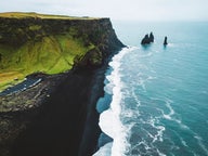
In South Iceland, a historical promontory towers majestically above the black glacial volcanic outwash, Mýrdalssandur.
This 221 meters tall promontory is called Hjörleifshöfði, named after the Viking Hjörleifur Hróðmarsson, who was killed on this spot.
Hjörleifur Hróðmarsson was the blood brother of Ingólfur Arnarson, who is considered to be our first Viking settler in around 874 AD.
I have written another travel-blog about Ingólfur and Hjörleifur and the death of Hjörleifur just a year after he arrived in Iceland.
Top photo: ruins of the old farm on Hjörleifshöfði

Road signs by Hjörleifshöfði
In this travel-blog, I am going to tell you about the people who inhabited Hjörleifshöfði, their family plot on the highest peak, and the ruins of their farms on the promontory.
And I am also going to show you what I found when we drove almost the whole circle around Hjörleifshöfði.
I have known about Hjörleifur's burial mound on top of Hjörleifshöfði for ages, and always as we passed Hjörleifshöfði I would look out for the highest peak thinking that I would never be able to see it up close as the cliffs were so steep and craggy.

Hjörleifshöfði cape
The old farm of Hjörleifur from around year 874 was to the west of Hjörleifshöfði as Hjörleifur and his men knew nothing about the dangers close by; that they were staying just south of the dangerous volcano Katla, which lurks beneath the ice cap of Mýrdalsjökull glacier - and that when Katla erupts it causes massive glacial floods.
This old farm was washed away in one such massive glacial outburst from Mt. Katla on the 11th of May 1721. Since then this location has been called Bæjarstaður (where the farmstead stood).
In 1860 what was left of the ruins of the farm could still be seen, and they can be seen on a Danish map of Iceland from 1904.

Mýrdalsjökull glacier and Katla
When Katla erupted in 1918 the massive floods totally ruined what was left of this old farm. What a shame - I would have loved seeing it.
Katla hasn't erupted since 1918 and we Icelanders are very aware of the fact that she is due to erupt any time now!
The hike to the top of Hjörleifshöfði

The start of the hike at Bæjarstaður
Now join me on the hike up to the highest peak of Hjörleifshöfði, where Hjörleifur's burial mound is said to be located.
It is strange really hiking up to the highest peak of Hjörleifshöfði, as the steep cliffs look so uninviting, but there are two locations on the west side where one can relatively easily hike up to the top.
One of the locations is at Bæjarstaður, where Hjörleifur's old farm was located, and the other one is through a pass called Klif, which leads up to the old ruins of the farms.
There are some parking spaces and good information signs on Hjörleifshöfði and the hike. The map in my photo below will give you a better idea of what to expect when you arrive at Hjörleifshöfði.

The information map by the parking lot at the beginning of the hike
We left our car by the information signs and hiked the ring clockwise from Bæjarstaður. At the beginning of the hike, a narrow path leads up a somewhat steep hill.
It was already a little late, 7 pm when we started ascending, but as the weather was so lovely on this 28th day of July we decided to do this hike.
From Bæjarstaður we hiked up Bæjarstaðagil canyon and up the beautiful areas in Hurðarbök and Dalabotn with the mountain castle Sauðafell on our left-hand side.
It was a little bit steep in the beginning but then I walked on grass and rubble always ascending a bit until I reached the highest point of Hjörleifshöfði.

I am not a great hiker so I was happy to see that the hike was relatively easy
The sun was shining, casting an orange hue on Hjörleifshöfði. I was a little bit worried that we would maybe be stuck up on Hjörleifshöfði in the twilight as I didn't know how long it would take us to finish this hike.
We ended up spending 2 hours on Hjörleifshöfði, not rushed at all, taking tons of photos and enjoying the breathtaking view on top, so I would say that this hike is at least 2 hours, depending on how much time you are going to stay on top of the promontory.
Finally, we reached the highest peak. As we were hurrying up the path seemed endless. But when you can see your goal in the distance gradually drawing in on it - you gain additional strength.

Hjörleifshaugur burial mound
When we reached the top we were greeted with a fantastic view in all directions. We checked out the burial mound of Hjörleifur and felt kind of strange standing by the grave of Ingólfur's blood brother.
I felt my Viking heritage so strong here and I was in awe being so close to such important events in the lives of the first Viking settlers of Iceland.
Next to the burial mound of Hjörleifur, you will find a unique family plot built in 1899.
In this family plot, some of the former inhabitants of Hjörleifshöfði are buried: Markús Loftsson, Markús's brother, Sigurður Loftsson and Áslaug Skæringsdóttir, the wife of Markús, and their unnamed child.

The family plot on Hjörleifshöfði and the cairn
I have written more about them a little further on in this travel-blog. As I had done this hike clockwise I first reached the highest peak and the family plot, and while descending again I visited the ruins of the old farms of these former inhabitants on Hjörleifshöfði.
There is also a peak-shaped monument to the liking of a large cairn. It was built by Danish surveyors. You can see this monument from afar and even when driving by on ring-road 1.
The view from the top of Hjörleifshöfði is breathtaking, as you can see from my photos. In the north, you can see Mýrdalsjökull glacier, Iceland's 4th largest glacier; beneath which the dreaded volcano Katla is lurking.
You can see the glacier on the left side in my photo above, but it was hidden behind clouds at the time of my visit.

On top of Hjörleifshöfði
In the south, you will see the black lava beaches and the sea - and to the west, there is a good view of Reynisdrangar cliffs by the village Vík.
We spent some time up on the highest peak enjoying this beautiful view, but it was so windy up there that we were kind of blowing away.
I couldn't tear myself away from this beautiful view though and will for sure be visiting Hjörleifshöfði again.
My father-in-law owns a part of a small cottage in this area, so I will be exploring this part of Iceland thoroughly later on.

The family plot
When we finally left the peak we signed our names in the guestbook on top of Hjörleifshöfði.
You can see the guestbook to the left of the cross on my photo of the family plot.
Don't forget to sign your name in it as well when you visit Hjörleifshöfði :)

Hiking on Hjörleifshöfði
We then went down the so-called Hjörleifshraun lava field and grass turfs with lots of tussocks.
It is not easy walking on tussocks, but you will find them in so many places in Iceland, caused by the ice in the wintertime followed by thaw.
We then turned and hiked to the edge of Bæjarbrekka cliff. From there the view was like something you would see in a fairy tale - I was totally mesmerized and felt like I had discovered s hobbit land ;)
Down in a green valley were ruins of 2 farms and several outhouses.

The old farms on Hjörleifshöfði
The sun was in my face, but I took a photo of this amazing sight, and I know you will agree with me.
I had another WOW moment and stood there for the longest time, just taking in the wonders of Iceland. Isn't this a pretty sight?
We could see as far as Reynisdrangar cliffs by Vík and the huge black sand plains and the sea. It was absolutely breathtaking.
And here you can see the southernmost point of the mainland of Iceland, Kötlutangi Spit.

The ruins, and Reynisdrangar in the distance
I was eager to see the ruins of these farms and hurried down the grassy hill towards the ruins.
All of a sudden I felt fear as it was windy and the path is relatively close to the steep cliffs on the south end of Hjörleifshöfði.
My husband just laughed at me telling me that I wasn't even close to the edge, but when fear takes over one stops thinking rationally. I have, fortunately, since my visit to Hjörleifshöfði, conquered my fear of heights with hypnosis.

By Hjörleifshöfði
There is a lot of fulmar in the cliffs during the nesting season of our migrating birds. The Icelandic word for a fulmar is "fýll" - and there is a joke in Iceland to say that you saw an elephant on the cliffs! The Icelandic word for an elephant is "fíll" and they are pronounced exactly the same! We locals always find this joke funny ;)
Men were roped down the precipices when hunting the chicks of the fulmar and collecting their eggs. The chicks were hunted right before they were able to fly away and there was massive hunting of the fulmar chick, probably way too much.
The inhabitants on Hjörleifshöfði had the right to the birds, the eggs, and everything that floated ashore, like driftwood and jetsam. So there were some perks from living on a promontory by the sea.
But there was a catch as Þykkvabæjarklaustur convent had the right to half the driftwood since 1340 and later on the church. The church got the major part and the farmers got the minor part.

Hiking on Hjörleifshöfði
Hjörleifshöfði was uninhabited for 32 years after the glacial outburst in 1721, when Þorvarður Steinsson built a lodge on the promontory, where it was relatively safer to live. He lived there only for a couple of years or until 1755.
The family of the last owners (until 2020) of Hjörleifshöfði lived from 1832 on Hjörleifshöfði when Loftur Guðmundsson moved to this place.
His son, the scholar Markús Loftsson (1828-1906) lived almost his entire life in a small turf house on Hjörleifshöfði.
You can see the ruins of the turf house, in which he lived, closest to the edge, very close actually. He wrote a book, Eldrit, about volcanic eruptions in Iceland.

The grave of Markús on Hjörleifshöfði
Markús had one experience with the hidden people (elves) in Hjörleifshöfði - which Markús's son, Kjartan, tells us about (in Icelandic) on an audiotape.
I love hearing stories about the hidden people (elves) in Iceland, and what Markús experienced is what many people in the olden times, who were much more connected to nature than we are now, often experienced.
I know that both my grandmothers and their siblings experienced encounters with the hidden people (elves).
The first story tells us of Markús returning home from a trip when he looked up at the north side of Hjörleifshöfði and saw a woman coming from under a rock on the promontory throwing something out of a trough onto the grass and then disappearing into what seemed like a door in the rock.
This is a typical sighting of the hidden people (elves), they often disappear into or come out of a door in the rock where they live.

The grave of Sigurður on Hjörleifshöfði
The second story on audio tape (in Icelandic) tells us about the brother of Markús, Sigurður Loftsson, returning home to Hjörleifshöfði from Vík on the black sand plains. A sudden blizzard blocked his view of the promontory.
He then saw a light high up and headed for the light, and as he had walked for a while he saw Hjörleifshöfði close by.
On Hjörleifshöfði there is a tall slope and a big rock up on the edge and it seemed to Sigurður that the light was shining from that spot. He gathered that the hidden people (elves) were showing him the way back home.
I love this story, it warms my heart to hear about the cooperation between the hidden people (elves) and us humans.

Runs on Hjörleifshöfði
Markús didn't want to change anything or upset anybody, as it were, at Hjörleifshöfði, to not disturb the hidden powers of the nature of Iceland.
When Markús died his wife, Áslaug Skæringsdóttir, who was 36 years younger than Markús, married Hallgrímur Bjarnason, who was their farmhand, and they built a house with some outhouses in 1908-1909 a little bit further from the edge of the promontory.
By doing so Hallgrímur and Áslaug went against the wishes of Markús and changed the old dwelling place.
Since that time it is said that Hjörleifshöfði has been so haunted that it was barely possible to live there anymore. And it is still said to be haunted.
I was not aware of anything out of the ordinary though.

Farm ruins on Hjörleifshöfði cape
Hallgrímur and Áslaug moved from Hjörleifshöfði in 1920 to Suður-Hvammur in Mýrdalur.
The reasons for them moving had probably nothing to do with the haunting of Hjörleifshöfði, but rather that Áslaug was ill and Hallgrímur wanted a better land to cultivate.
Tenant farmers then took up residence in Hjörleifshöfði and lived there until 1936. Since 1936 nobody has lived on the promontory.
See the farm ruins in my photo below - this is how close the farm was to the very edge of the steep cliffs! Very close, but the views from it must have been amazing.

Resting by the old farm ruins
We explored this area for a while and enjoyed the breathtaking view, but as we didn't know yet how to descend the promontory we went on our way sooner than we wanted.
We then found the path and descended Klif and the Slátturbrekka cliff, which was easy to do and we even saw a small pretty waterfall on the way.

A small waterfall on Hjörleifshöfði
We had to jump over a creek to be able to get back to Bæjarstaður to close the ring. My husband did that, picked up the car, and then picked me up and we drove as far around the promontory as we could.
The hike took us exactly 2 hours with a lot of photo stops.
You cannot get lost on top of Hjörleifshöfði seeing that there are no trees there, but I wouldn't want to be up there in fog or the darkness.
The area around Hjörleifshöfði

Arnardrangur pillar
There are several pillars of rock around Hjörleifshöfði. I have seen these pillars of rock in advertisements and in a beautiful Indian video, which I am totally hooked on.
It is shot in many locations in South Iceland, but I have added it here below as one of the locations is by this distinctive pillar of rock by Hjörleifshöfði promontory.
This beautiful pillar of rock with the protruding "head" is called Arnardrangur - I think it is ever so pretty.

There are several pillars of rock by Hjörleifshöfði - Arnardrangur and Lásadrangur
I walked around Arnardrangur (which is further away in my photo above) and the other pillars of rocks south of Hjörleifshöfði promontory.
It is totally different being up close and personal with these pillars of rock than just passing them by car.
The other pillars of rock are called Lásadrangur (the long one in the photo with Arnardrangur) and Latur (Lazy).
There is also a pillar of rock to the north of Hjörleifshöfði. It is called Drangur (Pillar of Rock) and you can see it in my second photo above in this travel-blog.
On the east side of Hjörleifshöfði, you will find another pillar of rock called Kötluklettur.
I didn't get a good enough photo of Kötluklettur, but it was carried with the massive glacial flood stream during the Katla eruptions.

It is lovely walking around Hjörleifshöfði checking out all the pillars of rock
In the olden times, the sea would reach this part, so when Hjörleifur and his men came to Iceland they must have sailed their ships straight up to Hjörleifshöfði. Imagine that!
Gýgjagjá - also known as the Yoda Cave

Can you see the resemblance to Yoda?
There is a huge cave called Gýgjagjá or Gígjagjá on the south side of Hjörleifshöfði - it is believed to be 20-30 meters high! The promontory is made of palagonite and parts of this cave seem to be man-made.
I find it to be so distinctive as there are two openings to the cave with a "bridge" separating the openings.
Just recently Gýgjagjá cave has been nicknamed the Yoda cave, as it is believed to resemble a huge Yoda when you photograph it from the inside of the cave.
I totally agree with this, even though I didn't see it on my first visit to the cave. Now I cannot look at the photos without seeing a huge Yoda :)

I look tiny compared to Gýgjagjá - the Yoda Cave
There are several other small caves in this part of Hjörleifshöfði. I examined some of them but was fascinated by this particular cave with this huge opening.
We now carried on driving as far as we could around the promontory. On the east side of Hjörleifshöfði, we found some strange signs; rocks had been lined up to make a circle and inside the circle, more rocks had been lined up like a cross pointing to a small circle in the middle - what was this?
I had no idea and asked around when I got back home, but nobody seemed to know about this. Finally, the experienced guide, Börkur, who was our guide on the Jökulsárlón glacial lagoon and the Ice Diamond beach tour rang up the owner of Hjörleifshöfði, who told him the story behind this circle.

Rocks had been lined up to make a circle
This circle was created for a German film that was shot by Hjörleifshöfði some 40 years ago - or around 1980. The film is called Viking Saga, starring the German actor Klaus Kinski and the Icelandic Ingibjörg Stefánsdóttir.
This film isn't listed under Klaus Kinski's films, but the owner of Hjörleifshöfði, Þórir Kjartansson, the descendant of the people who lived on Hjörleifshöfði, told me that this circle represented a Viking worship circle, hörgr or hearg in old English (blóthringur).
Usually, filmmakers tidy up after themselves so they leave no trail behind, but the owner asked them to leave this circle behind and I agree with him that it adds to the magic of this historical place.

The "blóthringur" from the Viking film
It was getting pretty dark by now and we couldn't get any further on our small car so we turned around and explored the southernmost part of the mainland of Iceland, Kötlutangi spit, on which I have written another travel-blog.
In 2020 after having been for sale for 4 years, Hjörleifshöfði and the land that reaches up to the glacier and Mt. Hafursey was sold.
Now, a company called Viking Park operates in this area. You can check them out both on Facebook and their website.
You now pay for parking by Hjörleifshöfði, and the fee goes to the upkeep of this area.
You can also pay a visit to the Katla ice caves north of Hjörleifshöfði by Mýrdalsjökull glacier.

Hjörleifshöfði
Hjörleifshöfði is on the south coast of Iceland, on Mýrdalssandur beach, just east of the village of Vík. To reach this area you can rent a car in Reykjavík and drive to Vík.
From Vík turn onto the road marked Hjörleifshöfði on your right-hand side. You can also join a guided tour of Hjörleifshöfði, which departs from Vík A hike to Hjörleifshöfði | The first settlers of Iceland
Here is the location of Hjörleifshöfði on the map. GPS: 63°25'13.2"N 18°44'58.0"W
Have a lovely time at Hjörleifshöfði and let's show utter respect on and by the promontory as we are here as guests :)