参加人数には限りがあります
早めのお申し込みがお得です
最安値をお約束します
手数料なし
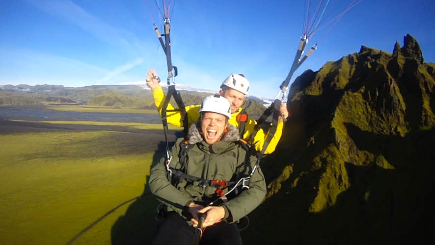
タンデム・パラグライディング|ヴィークの町発
空を飛んで新しい視点からアイスランドを見てみませんか?
このパラグライディングツアーは、アイスランドの南海岸でその日のコンディションにあった場所から飛び立つ、絶景を目にすることができるツアーです。木々の少ないアイスランドでは、その地形がはっきりと見え、スケールの大きな風景を見るには空からの観察が一番!
集合場所はヴィークの町にあるVik Hostelですが、その日のコンディションに合わせ、最適な場所へご案内します。
このツアーでは初心者でも可能なタンデム・フライトを行います。12歳以上のお子様や未経験の方も大歓迎です。パラグライダーが開いたら安全点検をします。そしてちょっと歩けば、あなたはもう空を飛んでいます!
ガイドがHD動画も録画し、ツアー後にSDカードでデータをお渡しするオプションもあります。
予約時には下記をよく読み、準備をして参加してください。
ツアー概要
- ツアー時期: 5月. - 9月.
- 所要時間: 2 時間
- アクティビティ: 観光, パラグライダー体験
- 難易度: ☆☆
- 最低年齢: 12 歳
- ツアーガイド言語: English, Icelandic
- ハイライト: Skógafoss,
Skógafoss is one of Iceland’s biggest and most beautiful waterfalls with an astounding width of 25 meters (82 feet) and a drop of 60 meters (197 feet).
Due to the amount of spray the cascade produces, at least one rainbow is present any time the sun emerges from behind the clouds.
Located on the Skógá river, this mighty cascade is clearly visible from Route 1 and is an excellent place to stop and stretch the legs while travelling Iceland’s South Coast. The river below Skógafoss holds a large char and salmon population and is thus a favourite spot for fishermen in the summer.
The land underneath the waterfall is very flat, allowing visitors to walk right up to the wall of water. This will get you drenched, although, on a summer’s day, it can be quite tempting.
Skógafoss can also be viewed from the top as a steep staircase leads to an observational platform above the cascade. Many nesting seabirds can be found on the route up.
Geography
Skógafoss is located near the small village of Skógar, south of the Eyjafjallajökull glacier volcano. There you’ll find the Skógasafn folk museum, an open-air museum with both old wooden houses and turf houses, as well as a regional museum with various artefacts from this area.
A part of the Skógasafn Regional Museum is the Museum of Transportation, which showcases the history and evolution of transportation, communication and technologies in Iceland. There, you can see how this nation evolved from the age of the working horse to the digital communications of the 21st century.
The Skógasafn museum also includes a café and a museum shop, and in the village of Skógar, you will find both a hotel and a restaurant.
At the eastern side of Skógafoss, you will find one of Iceland’s most famed hiking routes; the Fimmvörðuháls pass. The 22 kilometre (14 miles) trail takes you along Skógá river, between two glaciers, Mýrdalsjökull and Eyjafjallajökull, before ending in the beautiful Þórsmörk valley.
Skógafoss is often visited alongside the waterfall Seljalandsfoss, which is just a little further along the South Coast. Both fall from cliffs of the same height, and while Skógafoss is much more powerful, Seljalandsfoss has a cave behind it, which means it can be fully encircled. It is also next to a much lesser known but still awe-inspiring waterfall, Gljúfrabúi.
Folklore
A gold ring is on display at the Skógasafn museum. According to legend, the ring is from a chest that was owned by Þrasi Þórólfsson, one of the first Viking settlers in the area, who by some accounts was a giant. Folklore states that before his death in 900 AD, Þrasi buried a chest filled with gold in a cave behind Skógafoss waterfall.
Many attempts were made to retrieve the chest after Þrasi’s death, and years later, locals managed to grasp a ring on the side of the chest. As they pulled, the ring broke off, and the treasure was lost forever. The ring was then given to the local church before it made its way to the museum.
セリャランズフォスの滝,Seljalandsfoss is a waterfall that can be fully encircled, situated on the South Coast of Iceland with a drop of 60 metres (200 feet).
Due to the waterfall’s close proximity to the Ring Road and impressive natural features, it is one the country's most famous and visited falls. Majestic and picturesque, it is one of the most photographed features in all of Iceland.
Geology and Surroundings
Seljalandsfoss waterfall, part of the river Seljalandsá, has its origins underneath the glacier Eyjafjallajökull. The volcano beneath this ice cap was the one that erupted in 2010 and caused havoc at airports across Europe.
The cascade of the falls is relatively narrow but falls from a tall cliff that once marked the country's coastline, the sea is now located across a stretch of lowlands and is visible from the site.
The most distinguishing feature of Seljalandsfoss is a pathway that stretches all the way around it. The cliffs behind the falls have a wide cavern, and rocks and paths allow guests to fully encircle it in summer.
Though a mesmerising opportunity, visitors should be prepared to get dampened due to the perpetual mist of the falls, which also tends to make the rocks of the pathway slippery.
Floodlights have been set up on both sides of the waterfall, which impressively illuminate the scene during the night when the midnight sun is not out. The lights were installed in 2001 due to the growing popularity of the falls as a tourist destination.
After visiting Seljalandsfoss, it is common for visitors to continue north to the waterfall Gljúfrabúi, which is found partially hidden behind a rock face. Because of Seljalandsfoss extreme popularity, Gljúfrabúi is widely considered the hidden gem of the scene, as it is too often overlooked.
Seljalandsfoss is also usually visited alongside the nearby Skógafoss. The waterfall falls from the same height, and while it cannot be encircled, it is much more powerful and steeped in the legend of a giant’s hidden treasure.
Visitor Centre Controversy
In 2017, it was announced that a visitor’s centre was to be constructed near the falls. The design of the building indicated that it would be seven metres (23 feet) high and 2,000 square metres (21,500 square feet) in size. Landowners in the area opposed to the idea, proclaiming that the centre would greatly alter the natural appearance of the waterfall’s renowned scenery.
The project has neither been fully approved nor wholly cancelled, with ideas surfacing of either significantly reducing the size of the construction, or moving the visitor centre’s location further away, for instance to the nearby farmstead Brekkuhorn.
Seljalandsfoss in Popular Culture
Along with a multitude of South Iceland’s most famous natural attractions, Seljalandsfoss can be seen in Justin Bieber’s music video for his song ‘I’ll Show You’. Please enjoy the video without emulating any antics that will endanger yourself or the environment.
The waterfall was also a featured waypoint during the first leg of the sixth season of The Amazing Race, an American reality TV series.
レイニスドランガル,Reynisdrangar are impressive rock formations situated near the shore of Reynisfjara beach by the coastal village Vík on the South Coast of Iceland.
The formations are the remains of large and imposing sea cliffs, made up of basalt, that serve as a vital part of the area’s allure; they shoot dramatically out of the ocean under the looming cliffs of Mt. Reynisfjall, making for a beautiful site, and have a folklore that is equally impressive.
More modern visitors will be excited to know that these pillars also feature in Season 7 of Game of Thrones, at Eastwatch by the Sea.
Dangerous Waves
Before getting into the wonders of Reynisdrangar, it is important for potential visitors to be aware of the dangers at the site.
These majestic rock pillars rise from the sea just off of Reynisfjara, a famous black sand beach on the South Coast, by the village of Vík. Though incredible due to its diverse and dramatic geology, Reynisfjara is gaining a notorious reputation for its sneaker waves.
There are no significant landmasses between Antarctica and Reynisfjara, giving waves the entire length of the Atlantic Ocean to build strength. This means that even on still, summer days, they can rise from seemingly nowhere and chase far further up the sand than would ever be expected.
It is absolutely imperative, therefore, that guests stay at least 30 metres (98 feet) from the water’s edge. Those who flout these rules put their lives and the lives of others at risk; people have died here before.
Folklore
As with almost all bizarre features in this country, there is an Icelandic folk tale that explains the origin of the Reynisdrangar pillars and their eerie appearance.
According to legend, a couple of trolls saw a ship out to sea by night, and waded out to reach it. They got hold of it, and began to drag it to shore, but as so often happens in troll stories, they got their timing wrong.
Before they were even close to getting to the shade, dawn broke. The trolls and ship were instantly frozen into stone, and they have remained immortalised since, as a warning to their kin.
This is not the only folk tale in this area. According to local legend, two other trolls murdered a woman, whose husband hunted them down, tricked them into coming out at night, and ensured they too were turned to stone. Their remains can be found inland.
Surroundings & Wildlife
Most visitors will only see the Reynisfjara sea-stacks from the shore of Reynisfjara, although there is an incredibly rewarding alternative view of them from above. Those with a reasonable level of fitness can venture up the bewitching cliffs of Mt. Reynisfjall, by a road to the west of Vík.
The mountain furthermore holds thousands of puffins every summer, from May to August. These adorable creatures have very little fear of people, and can be approached within metres (although you should never try to touch them). Other birds can be seen gliding around the cliffs such as Arctic terns, fulmars and seagulls.
The oceans of Iceland are pregnant with life, so lucky visitors may also see seals in the water, or even one of Iceland’s twenty species of whale and dolphin.
南海岸The South Coast of Iceland is the country's most visited sightseeing route, along with the Golden Circle.
This incredible shoreline stretches from the greater Reykjavík area in the west to the magnificent Jökulsárlón glacier lagoon in the east and is lined with countless natural wonders such as cascading waterfalls, volcanoes, black sand beaches and glaciers.
Geography, Nature & Wildlife
The South Coast is the most easily accessible part of the country’s southern region, found along the Route 1 highway (the Ring Road), which encircles Iceland. The area consists of a diverse lowland that transitions between, marshlands, bays, cultivated pastures, estuaries and black sand deserts.
Underneath the soil rests a vast lava field, known as Þjórsárhraun. Its edges reach several hundred metres offshore where the ocean waves crash upon them, thereby protecting the lowland from the invasion of the sea. This results in the South Coast being unusually lacking in the deep fjords that so distinctly characterise the rest of Iceland's shoreline.
The region boasts vibrant bird life during all seasons. Freshwater birds nest in the marshlands and around the estuaries, while seabirds flock around the cliffs of Reynisdrangar and Dyrhólaey, including the North Atlantic puffin between May and August. Some species stay throughout the harsh Icelandic winter, including the northern diver, the loom and various species of gulls and ducks.
Seals are often found along the shore, particularly around the Jökulsárlón Glacier Lagoon and Diamond Beach. As with everywhere in Iceland, you should always keep an eye out to sea, as whales and dolphins reside all along its coastline.
Highlights of the South Coast
The South Coast offers an unprecedented array of natural wonders that draw thousands of visitors each day.
When driving the route from Reykjavík city, the first major features are the two great waterfalls of Seljalandsfoss and Skógafoss, which sit beneath the notorious subglacial volcano, Eyjafjallajökull. On clear days from these beautiful cascades, the Westman Islands can be seen across the ocean.
A little further down the route is the glacier Mýrdalsjökull, which covers one of Iceland’s most explosive volcanoes, Katla. Many glacier hikes are taken here upon the outlet of Sólheimajökull.
The aforementioned Dyrhólaey cliffs are next, home to many seabirds. Even if you come outside of puffin season, they are well worth a visit; jutting out to sea is an enormous rock arch of the same name, which you can marvel at from many angles.
Adjacent to the village of Vík is the famous black-sand beach, Reynisfjara, home to the rock pillars of Reynisdrangar, said to be two trolls frozen by the light of the sun. Though beautiful, this area is gaining notoriety for its dangerous sneaker waves, so visitors should be sure to stay well away from the edge of the water, even on a calm, still day.
There are no landmasses between Reynisfjara beach and the continent of Antarctica, so you can imagine how the waves can build momentum.
After passing through Vík, you will cross the glacial sand plain of Skeiðarársandur, before entering Vatnajökull National Park, home to the largest ice cap in Europe, Vatnajökull itself, dozens of glacial outlets and the magnificent Jökulsárlón glacier lagoon.
While almost all of these sites can be seen from Route 1, they make up a fraction of what the South Coast has to offer. The vast sand plains of Sólheimasandur are home to a crashed DC-3 Plane Wreck, and within the Vatnajökull National Park is the dramatic Skaftafell Nature Reserve.
Less than a kilometre from Seljalandsfoss is the hidden gem of Gljúfrabúi waterfall, and short distances from Jökulsárlón you will find the Diamond Beach, where icebergs wash on the black-sand shore, and another glacier lagoon, Fjallsárlón.
出発時刻 : 出発, 午後2時出発, 夜6時出発, 朝10時出発.
ヴィーク・ホステル(Vík Hostel, Suðurvíkurvegur 5, Vík í Mýrdal, South Iceland)
パラグライディング用の装備(ヘルメット込み)
フライト
必要なもの
ハイキングブーツなどのしっかりした靴
雨風に耐えられる暖かい服
ヘルメットの下にかぶる帽子(薄めのものがお勧め)
手袋
備考
飛行時間:
飛行時間はコンディションに大きく左右されます。アイスランドは天気や風の状態が変わりやすく、正確な飛行時間を予想することは困難です。10分から15分の飛行を予定していますが、コンディションが思わしくない場合には、それより短くなることもあります。そのような場合は事前にお伝えしますので、ツアーへの参加・不参加をお知らせください。
写真:一緒に飛行するパイロットがHDビデオカメラを装着して飛行しますので後でデータをもらうことができます。
安全について:
天候が良好な状態の時のみこのツアーを催行します。テイクオフ場所に到着した後でも、天候が思わしくない場合、良くなるのを待つか、また次回に延期することもあります。