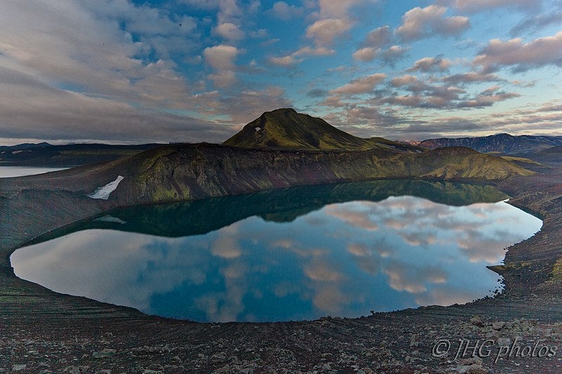
Travelers can discover Blahylur’s beauty on this full-day Landmannalaugar super jeep tour. Or, check out this magical 13-hour excursion to Landmannalaugar with hiking, hot spring bathing, and a visit to Blahylur lake.
Blahylur is a crater lake formed during an immense volcanic eruption in 871, just a few years before Iceland’s first settlers reportedly arrived. Today it’s a picturesque place for travelers visiting Landmannalaugar mountain to stop and appreciate the pristine beauty of the Icelandic Highlands.
저희의 콘텐츠를 신뢰할 수 있는 이유
가이드투아이슬란드는 아이슬란드에서 가장 믿을 수 있는 여행 플랫폼으로, 매년 수백만 명의 여행객이 저희와 함께 아이슬란드를 방문합니다. 저희의 모든 콘텐츠는 아이슬란드를 누구보다 잘 아는 현지 전문가들이 작성하고 검토하므로, 정확하고 신뢰할 수 있는 최신 여행 정보만 제공합니다.
Photo from Wikimedia, Creative Commons, by Jon Gretarsson No edits made
Geology and Features of Blahylur (Hnausapollur) Lake
In 871, catastrophic-level volcanic activity from the Torfajokull and Bardarbunga stratovolcanos had far-reaching effects across the Icelandic Highlands, including the formation of Blahylur.
Blahylur is a maar, a type of volcanic crater that forms when groundwater contacts hot lava. Typically, a maar fills with water to create a shallow crater lake, as it did with Blahylur.
Blahylur got its name from the deep blue color of its water. The striking contrast of the blue water against darker browns, greens and greys forms a landscape of incredible beauty.
The lake covers an area of around 30 hectares (74 acres), sitting at 1870 feet (570 meters) above sea level. Blahylur is home to small brown trout that some people choose to climb into the crater to fish.
It’s easy enough for visitors to walk down to the lake to appreciate a close-up view of the water. A short walk to the crater’s highest point offers unbeatable views down to the lake and across the surrounding terrain.
Location and How to Get to Blahylur (Hnausapollur) Lake
Blahylur lake is in the Fjallabak nature reserve, loved for its colorful mountains and valleys. It’s 5.6 miles (9 kilometers) north of Landmannalaugar mountain. The Laugavegur hiking trail, one of Iceland’s most famous treks, connects Landmannalaugar with the Thorsmork nature reserve.
Blahylur is just 3.4 miles (5.5 kilometers) northwest of Ljotipollur, another crater lake. A bit further south lies the larger Frostastadavatn lake. Travelers could visit all three lakes, just a short drive from one another as they head south to Landmannalaugar or north after visiting this area.
From Landmannalaugar, take F-road 208 north. You’ll first pass Frostastadavatn on the left, followed by Ljotipollur, then Blahylur on the right.
Attractions Near Blahylur (Hnausapollur) Lake
The Icelandic Highlands is a not-to-be-missed summer destination. Take a self-drive tour to experience this off-the-beaten-track destination's natural wonders and serenity.
Don’t miss Landmannalaugar with its colorful rhyolite mountains. It’s an excellent location for hiking and bathing in natural geothermal pools. Landmannalaugar marks the north end of the Laugavegur hiking trail and has camping facilities, making it an ideal base for exploring the Highlands.
Thorsmork is at the south end of the Laugavegur hiking trail and is known for its breathtaking scenery. Contrasts of black deserts, lush greenery, and ice-capped peaks form an awe-inspiring rugged landscape. The Laugavegur trail is 34 miles (55 kilometers) long, but if you plan to drive from Blahylur to Thorsmork, the distance is 97 miles (157 kilometers).
The Southern Highlands is full of natural treasures. While in the area, visit the pristine Sigoldufoss waterfall, 12.2 miles (19.7 kilometers) north of Blahylur.
Ofaerufoss waterfall is 25.8 miles (41.6 kilometers) southeast of Blahylur. It boasts a multi-level cascade in the Eldgja canyon, accessed by a short, scenic hike.


