


Description
Summary
Description
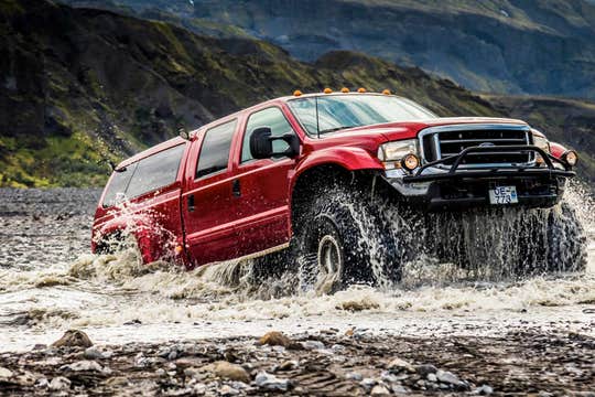
Discover one of Iceland’s natural gems, Þórsmörk valley, on this exciting super jeep tour. Þórsmörk’s jaw-dropping landscape is credited to the fact that it is surrounded by the volcanic glaciers, rough terrain, unbridged rivers and mind-blowing wilderness. This tour shouldn’t be missed by anyone wanting to experience the true magic of Iceland’s nature while travelling in comfort.
Þórsmörk will provide you with an experience of a lifetime. The name means “Valley of Thor” (the Viking Thunder God), and it is a vast area of unique beauty. It is located in south Iceland, and it is nestled between three glaciers: Mýrdalsjökull, Tindfjallajökull and the famous Eyjafjallajökull glacier volcano which erupted in 2010.
From Hvolsvöllur town, you will travel in a specially adapted super jeep, capable of handling rough terrain and cross un-bridged rivers. The super jeep allows you to experience the magnificence and power of Þórsmörk’s nature.
On the way into the valley, you will make various stops, including one at Gígjökull, an outlet glacier from where powerful glacial floods escaped during an eruption of Eyjafjallajökull. Your local guide will take you through the Eyjafjallajökull eruptions scenes, giving you a full and very vivid account of the action that roared through the area in April 2010.
Once in Þórsmörk, you will continue marvelling at its unique colours and panoramic views. You make several stops to take in Þórsmörk’s untouched wilderness. There are also endless possibilities for short hikes for even more spectacular scenes, like to the mighty Valahnúkur mountain.
Don't miss this unique opportunity to travel to the green oasis of Þórsmörk in the comfort of a super jeep with an experienced and passionate local guide. Check availability by choosing a date.


