I have recently written a travel blog about my favourite volcanic craters in Iceland.
Now I want to show you an interesting phenomenon: pseudocraters, which can be found in very few places in the world: Iceland, Hawaii, one in the Azores islands, and the Athabasca Valles region of Mars, as far as I know.
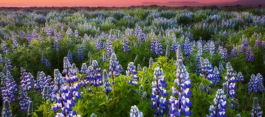
Top photo: Skútustaðagígar pseudo craters
 Skútustaðagígar on a sunny autumn day in 2024
I have often heard that Iceland is a feast for geologists, and the pseudocraters are for sure a valuable addition to that feast.
These rootless craters form when piping-hot, thin-flowing molten lava flows over wetlands or boggy areas.
The hot lava boils the wetland water, and the steam pressure causes explosions that create clusters of pseudocraters.
Skútustaðagígar pseudocraters

Skútustaðagígar pseudocraters
The biggest pseudocraters in Iceland are the Skútustaðagígar pseudocraters in the Mývatn area in North Iceland.
They are amongst the many extraordinary sights of the Mývatn area, and one of the most interesting natural phenomena in Iceland.
And the first sight in Mývatn, which people who are driving the circle of Iceland clockwise see when they enter the Mývatn area.

Skútustaðagígar pseudocraters
These pseudocraters were formed some 2,300 years ago in the eruption of Lúdentaborgir and Þrengslaborgir. The clusters of pseudocraters sit on a scoria mount, which is unique for this type of crater.
Skútustaðagígar craters are, in my opinion, the most spectacular pseudocraters in Iceland, at least among those I have visited. They are very distinctive and look like big bowls.
Skútustaðagígar pseudocraters are easily visited as they are right by the road.
The pseudocraters are sometimes called rootless craters or rootless cones, as they have no end to them, as it were, i.e., they are not connected to a direct magma conduit.
A path will take you on an interesting walk amongst these beautiful rootless craters with a view of Lake Mývatn, Iceland's 4th largest lake.
If several explosions occur, they look a lot like normal volcanic craters, with crater bowls, and you might think they are real craters that have erupted.
Sheep by Skútustaðagígar pseudocraters
If only a few explosions occur, these pseudo craters don't form a volcanic bowl and instead look more like hills.
While visiting these rootless craters, you will notice the difference between them.
Some are grassy hills, while others have grassy volcanic bowls, and other variations are lava cones with lava spatter and scoria that were shot up during the explosions.

Photo by Iurie Belegurschi
Skútustaðagígar pseudocraters were designated a natural monument in 1973, and the protected area is approximately 70 ha in size.
The photo above is by Iurie, one of the co-founders of Guide to Iceland and a fantastic photographer.
I got his permission to post a photo of the Skútustaðagígar pseudocraters, which he shot with a drone.

The distance from Reykjavík to Skútustaðagígar pseudo craters
Read more about this area in my travel blog: The amazing Mývatn Area in North Iceland - Part I
Rauðhólar pseudocraters

Rauðhólar pseudocraters
In southwest Iceland, only a stone's throw away from Reykjavík, the capital city of Iceland, you will be able to visit another cluster of pseudocraters - the Rauðhólar - Red Hills rootless craters.
They are very distinctive due to their dark maroon colour.
Rauðhólar pseudocraters, which are around 5,000 years old, are located in the Heiðmörk Nature Reserve. They are part of the Leitahraun lava field, which originated in an eruption from the shield volcano Leiti.

Rauðhólar pseudocraters
The part of the Leitahraun lava field where Rauðhólar formed is called the Elliðaárhraun lava field, but the salmon river, Elliðaár, runs through parts of Reykjavík city.
Rauðhólar pseudocraters are easily accessible and visible from Ring Road 1 on the eastern outskirts of Reykjavík.
They were preserved back in 1961 and protected as a natural monument in 1974 after truckloads of gravel were removed from them to use in a landfill, e.g., Reykjavík domestic airport.

Read more in my travel blog: The mystical Rauðhólar Pseudocraters & Tröllabörn - the Troll Children in SW-Iceland
Landbrotshólar pseudocraters

Landbrotshólar pseudocraters
In South Iceland, in the Katla UNESCO Global Geopark, you will find Landbrotshólar pseudocraters, the most extensive area of this interesting phenomenon in Iceland.
These pseudocraters, which cover an area of around 50 sq. km, were most likely formed in the gigantic volcanic eruption in Eldgjá during the years 934-938.
Some of these pseudocraters are hollow craters, ideal to keep "stuff" and act as a natural shelter.
Some of them have been used to keep sheep, and I saw one crater filled with rusting iron and timber (hopefully just kept there temporarily).

Landbrotshólar pseudocraters
My husband loves to look inside caves, so he crawled into one of the pseudocraters at Landbrot and had a look around. Pseudocraters are delicate, though, and preserved, so let's tread very lightly here.
The pseudocraters are hidden from view from Ring Road 1, but if you turn on Road 204, Meðallandsvegur, they become visible.
We found a gravel road that took us into a pseudocrater area. We drove in between them and hopped out when we saw an interesting-looking pseudocrater.

My husband inside Landbrotshólar pseudocraters
There is a myriad of pseudocraters in this area, some of which look like cones and pyramids, and others which are round and look like bosoms.
A tour guide once told me that he got very distracted sometimes driving with all these bosoms around ;) And you can see why if you have a look at my photo below.

Landbrotshólar pseudocraters
The pseudocraters are not marked on Google Maps, but we followed a gravel road close to the Efri-Vík farm and Hotel Laki, where we were staying for the night.
An aerial view on Google Maps shows the pseudocraters very clearly - I am amazed at how many there are.
In the vicinity is Kirkjubæjarklaustur with many natural wonders.

In this area, you will also find an elf-city and an elf-church, an 11th-century wall called Bjarnagarður, and an ash bunker, where you can see ash layers from different volcanic eruptions, even as far back as before the year 900.
You can read more about this very interesting area in my travel blog: Hotel Laki and its Amazing Surroundings in South Iceland.
Álftaversgígar pseudocraters

Álftaversgígar pseudocraters
After driving through the vast lava sand plains of Mýrdalssandur in South Iceland, you will notice a change in the landscape.
Here, Álftaversgígar, a cluster of pseudocraters, begins to pop up out of the flat landscape.
They make the landscape look very distinctive, and they also conveniently serve as a barrier to the massive glacial floods during the Katla eruptions.
Here, the pseudocraters look like spatter cones, which means that the power of the explosions that created them was not as massive as was the case in some of the pseudocraters in North Iceland.

Álftaversgígar pseudocraters - útsýnisskífa means a view-dial
These pseudocraters, such as Landbrotshólar pseudocraters, were most likely formed during the Eldgjá eruption in 934.
They were protected as a natural monument in 1975, but many of the pseudocraters in Iceland are now protected.
I am grateful for that, as some of these pseudocraters might have been completely destroyed and used for road construction or airport construction, as with the Rauðhólar pseudocraters.

By the view-dial on top of Álftaversgígar pseudocraters
On top of one of the pseudocraters, you will find steps leading up to a view-dial.
My father-in-law, Jakob Hálfdanarson, has designed many of the view-dials in Iceland, and I search for them on my travels around Iceland.
There are over 90 view-dials all over Iceland, some easily accessible, like this one, but others on top of mountains. These view-dials show the names and heights of the mountains in the surrounding area.
I have managed to take photos of almost all of them, except those on mountain tops, as I am far from being a good hiker.

The view-dial on top of Álftaversgígar (one of them)
I have added photos and information about the view-dials in many of my travel blogs, but one travel blog I dedicated to the view-dials in the Westfjords of Iceland:
View-dials - Hringsjár - in the Westfjords of Iceland
The Álftaversgígar pseudocraters are right by Ring Road 1, and my photos were taken by the intersection of Ring Road 1 and Road 211.
Other pseudocraters I have seen on my travels

Rauðhólar pseudocraters in Laxárdalur valley in North Iceland
I found a cluster of maroon pseudocraters in Laxárdalur valley in North Iceland. They are also called Rauðhólar - Red Hills, like the maroon pseudocraters in South Iceland, which I mentioned earlier.
You can stop by the pseudocraters and have a look around. I have ties to this valley and have many times walked around surrounded by red pseudocraters.
A little bit further up in Laxárdalur valley, you will find the majestic-looking Þverá turf house. It is still closed to visitors, but you can have a look at it from the outside.
The famous river Laxá flows through this beautiful valley, originating at Lake Mývatn.

There are other pseudocraters in the Aðalhraun lava field close by.
This area is truly amazing; you drive through what looks like another planet for a while on your way from Mývatn to Húsavík.
The pseudocraters in the photo below form a cluster near the intersection of roads 85 and 845 leading to Húsavík. They are clearly visible on Google Maps.

Pseudocraters in Aðalhraun
Some of these pseudocraters look like the more normal hilly pseudocraters, while others look like spatter cones and hornitos, and maybe some of them are.
I am not a geologist, just trying to make sense of this strange phenomenon in my country ;)
You can see more strange lava formations in this area in my travel blog on the Peculiar Knútsstaðaborg.

Pseudocraters in Þjórsárdalur valley upcountry in South Iceland
Other places in Iceland where pseudocraters can be found are in Þjórsárdalur valley, upcountry in South Iceland.
I have written several travel blogs about Þjórsárdalur, but have only driven by some of the pseudocraters on my way to Stöng and Gjáin. I looked them up on Google Maps, and they are clearly visible if you zoom in.
I found the map below showing the locations of the pseudocraters in Iceland on the website of Umhverfisstofnun (the Environmental Agency) and on the webpage of the Natural Research Station of Mývatn.
I hope they don't mind me using it for my travel blog.

A map of pseudocraters in Iceland
Now, these are the pseudocraters that I have seen on my travels in Iceland, and I hope you find this subject as interesting as I do.
This is only one of my 320 travel blogs about Iceland, so there are plenty of other interesting sights in Iceland to read up on and visit.
To visit these pseudocraters, it is best to rent a car and drive around Iceland on your own.
Have a lovely time in Iceland :)
Sources:

Hi, my name is Regína Hrönn, and I was born and raised here in Iceland.