Limited availability
Reserve early to save money
Best price guaranteed
No booking fees
Diamond Circle Flying Tour in North Iceland
Fly above north Iceland’s most incredible sites, with this flightseeing tour of the Diamond Circle. This amazing trip should not be missed by any who want to see the essential landmarks of the region from a fantastic aerial perspective.
This tour begins at Akureyri’s Domestic Airport, where your little plane will be waiting. After a quick briefing on your route from your friendly pilot, you will board the craft and take to the skies.
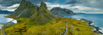
Your breath is sure to be taken away instantly; watching the ‘Capital of the North’, with its colourful tin roofs and beautiful buildings, shrink beneath you is awe-inspiring, as is the mighty bay of Eyjafjörður, and the giant mountains of Tröllaskagi. After circling above Akureyri, you will set out on the most popular route of the region, the Diamond Circle.
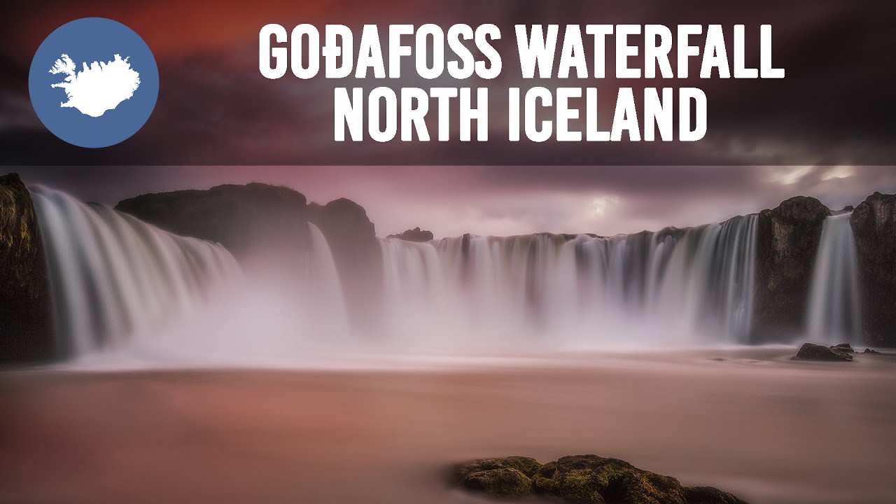
You will sail over the packed tour buses slogging along below until reaching the first site. Goðafoss waterfall is a stunning feature, wide and powerful, with a fascinating history. It was here that Iceland marked its conversion to Christianity, when the most powerful man at the time, the Law Speaker of the parliament, tossed his idols of the Old Norse Gods into the furious waters.
Next on your route is Lake Mývatn. Only from above can you comprehend the vastness of this place, with its many lagoons, separated by rows of pseudo-craters and lava formations. You will be able to see the basalt fortress of Dimmuborgir, and the tiny village of Reykjahlíð. Mývatn’s name means ‘midge lake’, so an added advantage of flying over it is that the millions of little flies won’t annoy you while admiring.
As you continue above the Diamond Circle, you will come across the seething geothermal region of the Námaskarð Pass. Here, you can see hot springs and fumaroles steaming, interrupting an ominous, barren landscape.
After going over this area and around the mountain, you will come to the valley of Jökulsá á Fjöllum, a surging glacial river that holds the most powerful waterfall in Europe, Dettifoss. From land, it is breathtaking, but from the sky, beyond that. Its scale and sheer power will lock your eyes upon it in awe as you circle above it.
On your return journey to Akureyri, you will hug the dramatic mountains of Tröllaskagi, admiring the peaks and seascapes, before touching down back at the domestic airport.
Don’t miss this exhilarating flight above the fantastic sites of the Diamond Circle. Check availability by choosing a date.
Quick facts
- Available: All year
- Duration: 1,5 hours
- Activities: Sightseeing
- Difficulty: Easy
- Languages: English
- Attractions: North Iceland,
North Iceland is a beautiful region, hosting some of the best attractions on the island.
Home to the Lake Mývatn region, the town of Akureyri (otherwise known as the 'Capital of the North'), the whale-watching hot-spot of Húsavík and the northern parts of Vatnajökull National Park, the North attracts visitors throughout the year.
It is divided by fjords and mountain ranges into many beautiful regions.
Eyjafjordur
Within the bay of Eyjafjörður is Akureyri, a town of 17,000 inhabitants. It is the largest settlement outside of the Greater Reykjavík Area.
It is easy to reach via the Ring Road, and many cruise ships land in the port of the town.
The older part of Akureyri is particularly worth a stroll, as it contains many historic buildings. The town is also home to many interesting museums, galleries, and the world’s northernmost botanical gardens.
If you like skiing or snowboarding, one of the best skiing sites in the country is located nearby.
Siglufjordur
Siglufjörður straddles the border of Eyjafjörður and Skagafjörður and is most famously home to a charming settlement of the same name.
Other than its natural beauty, with huge cliffs bordering the town, Siglufjörður is renowned for its fascinating museums.
There is a folk music museum, which comes alive during an annual festival, and the Herring Era Museum. The latter is the only Icelandic museum to win an international award and is much more interesting than it sounds; it explains how Iceland managed to survive a millennium in such harsh climes by relying on the seas.
The Vatnsnes Peninsula
The Vatnsnes Peninsula gets its fame for two reasons. Firstly, it is the best seal-watching location in the whole country, with colonies hauling out throughout the year. In the town of Hvammstangi, you can visit the Icelandic Seal Centre to learn more about these animals.
It is also famous for hosting the coastal rock formation of Hvítserkur. This bizarre feature is said to be a troll frozen by the light of the morning sun, but to most, it appears to be more like an elephant drinking from the ocean.
Thingeyjarsysla
Þingeyjarsýsla county is home to many incredible sites, particularly due to the fact that the Lake Mývatn region is nestled within it. This beautiful area is renowned for its lava formations, pseudocraters and rich birdlife.
Near Mývatn is the impressive lava field Dimmuborgir, which was featured in the Game of Thrones series. There is also the incredible waterfall Goðafoss, a beautiful feature between Lake Mývatn itself and Akureyri.
Húsavík is a nearby town, considered the whale watching capital of Europe. In summer, many operators see Humpback Whales every time they leave the port.
The Jökulsárgljúfur Canyon is home to some of Iceland's most beloved natural attractions; the river Jökulsá á Fjöllum runs through it and holds several waterfalls including Europe's most powerful, Dettifoss. Nearby to here is the spectacular, horseshoe-shaped Ásbyrgi canyon.
Grimsey
Far north, straddling the Arctic Circle is Grímsey island, the northernmost inhabited territory of Iceland, with a population of about 100 people. It is renowned for its fishing, its rich vegetation and birdlife, particularly puffins.
Akureyri,Akureyri, ‘The Capital of the North’ is a town in the fjord Eyjafjörður in North Iceland. It lies just 100 kilometres (62 miles) away from the Arctic Circle. It is Iceland’s second-largest urban area with a population of about 17,800.
Economy
Akureyri is an important fishing centre and port, but in the last few years, tourism, industry, higher education and services have become the fastest growing sectors of the economy.
An airport is located about three kilometres (two miles) from the centre and a large number of cruise ships lay anchor in its busy harbour.
Traditionally Akureyri has survived on fisheries and some of Iceland’s largest fishing companies such as Samherji, have their headquarters there. Other large companies are also based here, such as Vifilfell hf, the largest brewery in Iceland, which produces the famous Kaldi beer.
FSA/Akureyri Hospital is a significant employer in the area and is one of two major hospitals in Iceland.
Akureyri has excellent facilities for travellers and is located a short drive from many of Iceland’s top natural, cultural and historical attractions. Additionally, one of Iceland's best skiing sites is found by Akureyri, at Hlíðarfjall and it is the location for Ak Extreme, an annual skiing and snowboarding festival.
Nature & Landscape
Akureyri is surrounded by mountains, the highest one being Kerling at 1,538 metres (5,064 feet). The area around it has rich agriculture and a beautiful mountain ring.
The island of Hrísey sits in the middle of Eyjafjörður and Grímsey Island, which straddles the Arctic Circle; both islands belong to the municipality of Akureyri. Hrísey is often called 'The Pearl of Eyjafjörður’ and Grímsey 'The Pearl of the Arctic', and these beautiful and peaceful islands are highly popular with travellers.
Both are also home to many puffins.
Furthermore, Akureyri is a very popular place to stay due to its proximity to the Lake Mývatn. This is one of the country’s most popular destinations, due to its incredible natural beauty, intense geothermal activity, a wealth of birdlife and many surrounding sites, including Dettifoss waterfall, the most powerful waterfall in Europe.
It is also close to the seal-watching capital of Iceland, Hvammstangi, on the Vatnsnes Peninsula. This peninsula is also home to the captivating ‘elephant rock’ formation, called Hvítserkur.
The convenience of Akureyri is added to by its position on the Icelandic Ring Road, a route that encircles the country, passing almost every major destination. This means that reaching it from Reykjavík is little trouble, even in winter and the journey takes just under five hours.
History & Culture
During World War II, Akureyri was an essential site for the Allies and the town grew considerably after the war, as people increasingly moved to urban areas.
Akureyri has an active cultural scene, with several bars and renowned restaurants as well as frequent concerts and shows. During the summer there are several notable festivals in Akureyri and its surroundings such as the Vaka Folk festival.
Sites of interest in Akureyri include the brand-new Hof concert hall, many museums and the Christmas house which is open all year round.
The city boasts the world's northernmost botanical gardens which are located close to the swimming pool which is worth a visit.
Akureyrarkirkja church sits in a prized position halfway up the hill upon which most of the city is built. It was completed in 1940 and was designed by one of Iceland's most famous architects, Guðjón Samúelsson, who also was also responsible for arguably Iceland's most famous church, Hallgrímskirkja in Reykjavík.
Mývatn,Mývatn is a beautiful lake with many small islands in the north of Iceland, the fourth largest lake in the country. Due to its serenity, birdlife and volcanism, the lake, including its surrounding area, is one of the most amazing natural attractions in the country.
Mývatn is, in fact, so beautiful that is was used as a site in the Game of Thrones franchise. In mid-winter it was used to represent the lands North of the Wall, namely Mance Raider’s Wildling camp.
Geology
Mývatn sits about an incredibly active geothermal area, giving it a unique and beautiful geology. After all, it is close to sites such as Krafla caldera, which contains the notorious Víti volcano, the name of which translates to ‘hell’.
Many of the islands here are thus pseudocraters, formed by steam explosions as magma rose beneath pockets of water, and many are bizarre basalt columns, rising vertically from the surface, formed by rapid cooling after an eruption.
The high amount of geothermal activity beneath Mývatn, of course, presents the opportunity for bathing in naturally heated waters. This is best done at the Mývatn Nature Baths, a beautiful establishment with serene waters, incredible views, and a reasonable entry fee.
Wildlife
Mývatn has some of the best bird-watching available in Iceland, although those seeking puffins will need to be at coastal cliffs such as those at Látrabjarg and Dyrhólaey, between May and September.
In fact, Mývatn has more species of duck than anywhere else in the world, with thirteen nesting species and many more visitors. Most popular (and common) amongst these is the harlequin duck sometimes referred to as the white-eyed diver after their unique white markings.
Mývatn’s surrounding vegetation and plentiful food make it a happy home for voles, mice and rats that have spread all over Iceland, providing tasty treats for Iceland’s only native land mammal, the Arctic Fox. Visitors, however, will have to keep a close eye out for these, as they are experts in camouflage.
In terms of flora, the most interesting plant life at Mývatn actually exists just beneath the surface of the water. Marimo are ‘moss balls’, bizarre spheres of fluffy green algae that are found in very few other places around the world, namely Japan (where they got their name), Scotland, Estonia and Australia.
Surrounding sites
Visitors to Mývatn often wish to spend more than just a single day exploring its many surrounding locations. Primary amongst these is Dimmuborgir, a lava field which truly reflects the dramatic consequences of a volcanism in Iceland. This area is steeped in folklore and is home to the thirteen ‘Santas’ of Iceland, the Yule Lads.
It was also here that many of the Game of Thrones scenes were shot such as Mance Rayder's wildling camp at Dimmuborgir and Grjótagjá cave, where Jon and Ygritte shared an evening together. Though this site can be admired from the shore, the water temperature is not monitored and can heat up very quickly, so visitors are asked not to take a dip.
Those with an interest in Iceland’s strange geothermal and geological sites should also check out the Skútustadagígar pseudo-craters and the aforementioned Víti crater and its surrounding lava field. There are also several geothermal hot spots around Krafla and the Námaskarð Pass which is a fascinating and primordial place.
Lake Mývatn is located on the Ring Road that fully encircles the country, making further sites easily reachable. To the west is the ‘Capital of the North’, Akureyri, a charming town with the highest population outside of the capital area.
To the east, you can find the largest waterfall in Iceland, Dettifoss which also happens to be the most powerful waterfall in Europe, and the incredible horseshoe-shaped canyon, Ásbyrgi. This feature was said to have formed by the stomping of one of the feet of Oðinn’s eight-legged horse as it leapt through the sky.
Ásbyrgi,Ásbyrgi Canyon is a spectacular horseshoe-shaped depression in the northeast of Iceland, steeped in folklore.
It is found only fifty miles east of Húsavík along the popular Diamond Circle route.
Geography of Ásbyrgi Canyon
This beloved natural feature measures approximately 3.5 kilometres (2.2 miles) in length and 1.1 kilometres (0.7 miles) in width. It is only a small corner of the extensive and dramatic Vatnajökull National Park, but undoubtedly one of its most breathtaking.
Visitors to Ásbyrgi will quickly take note of the canyon’s 100 metre (328) feet high cliff faces, as well as the thick woodland of birch and willow below, creating an area quite unlike that found anywhere else across Iceland.
Other tree species here include spruce, larch and pine, and there is a small lake called Botnstjörn which visitors can hike to. One of the canyon's most distinctive features is Eyjan ("The Island"), a 25m rock formation that divides Ásbyrgi for almost half its length.
Formation and Folklore of Ásbyrgi Canyon
Geologists estimate that Ásbyrgi Canyon began to form roughly eight to ten million years ago, just after the last Ice Age, following a catastrophic glacial flooding of the Jökulsá á Fjöllum river. This flooding likely occurred due to a volcanic eruption beneath the ice-cap, Vatnajökull glacier.
Later, only 3000 years ago, this process repeated itself, further sculpting the soul-stirring, spectacular gorge that we know and love today.
With that being said, Icelandic folklore dictates an alternative theory, as it does with many of the landmarks around the country. Given the canyon’s horseshoe shape, legend has it that Odin’s eight-legged steed, Sleipnir, placed one of his feet on the ground here, leaving a deep imprint on the earth, as it sprinted across the sky.
A wealth of art and literature has depicted Sleipnir as Ásbyrgi’s true creator. Other myths claim that Ásbyrgi is the capital city and true home to Iceland’s ‘hidden people’, the Huldufólk and elves. Many of Iceland’s folk stories revolve around these strange, magical people and the bizarre punishments and plots.
Self-professed psychics have claimed that they can see and hear these mystical beings living in cracks and ravines of the canyon. Much more likely to be hidden in the woodland, however, are Arctic Foxes.
Attractions near Ásbyrgi Canyon
Thankfully, a number of other fascinating attractions are easily accessible from Ásbyrgi Canyon. One could visit Hljóðaklettar, a strange and enchanting cluster of columnar rock formations located in the neighbouring Jökulsárgljúfur canyon.
Nearby, there is also Europe’s most powerful waterfall, Dettifoss, a striking and mighty spectacle for any observer; glacial water from the Jökulsá á Fjöllum cascades 44 metres (144 ft) over the lip of the falls, culminating in a misty, roaring spray.
The video below shows one of Iceland’s most famous post-rock bands, Sigur Ros, who chose to play an outdoor concert at Ásbyrgi in 2006, only adding to the area’s rich and ethereal atmosphere. This and the rest of their performances can be seen in the film Heima (2007).
Goðafoss,Goðafoss waterfall is located in the river Skjálfandafljót in north Iceland, the fourth largest river in Iceland. It is one of the most spectacular waterfalls in the country, falling from a height of 12 metres (39 feet) over a width of 30 metres (98 feet).
History of Goðafoss
The name Goðafoss means either waterfall of the gods or waterfall of the 'goði' (i.e. priest/ chieftain). The reason for this is its fascinating history.
When Iceland was first settled in the 9th and 10th Centuries, the vast majority (who were not slaves, at least) were Norwegians who followed the Old Norse religion, worshipping deities like Thor, Odin, Loki and Freya. However, after the Commonwealth was established in 930 AD, pressure to convert began to push from Christianising Europe.
By 1000 AD, it seemed that Norway would almost certainly invade if the country were to stand by their pagan beliefs. The issue was thus discussed at Þingvellir, where the parliament met once a year. The lawspeaker at the time, the Ásatrú priest (or goði) Þorgeir Ljósvetningagoði, was given the responsibility to make the decision.
It is said he sat beneath a birch for a day and a night in silence, praying to his Old Gods for the right decision. Eventually, he emerged and said, for the good of the people, Christianity would be the official religion, but pagans could practice in private.
To symbolise his decision, he returned to his home in north Iceland and threw idols of the Old Gods into a beautiful waterfall. Since then, it would be known as Goðafoss.
Getting to Goðafoss
Goðafoss is located in north Iceland, on the Ring Road that fully encircles the country. It is considered part of the Diamond Circle sightseeing route.
This trail also takes visitors to the Lake Mývatn area, Dettifoss Waterfall, Ásbyrgi Canyon and the town of Húsavík.
Mývatn is a beautiful lake, filled with a wealth of birdlife, and it is renowned for it incredible surroundings, which include fortresses and of lava, geothermal areas, craters and basalt pillars. Dettifoss is another waterfall, and though it does not have the history of Goðafoss, it has much more power; it is, in fact, the most powerful waterfall in Europe.
Ásbyrgi Canyon, meanwhile, is also linked to the Old Norse Gods. Its perfect horseshoe shape was said to have been created by the stomping of one of the hoofs of the eight-legged steed of Odin. The final destination on the Diamond Circle is Húsavík, the best place for whale-watching in Iceland.
Outside of the Diamond Circle, Goðafoss, is easily reached by travelling for 45 minutes east by car from the capital of the north, Akureyri.
This is the largest settlement outside of the Greater Reykjavík Area and is a perfect place to stay for those travelling the circle around the country. It is a renowned cultural centre, with many museums, galleries and the world’s northernmost botanical gardens. Many tours depart from here.
Goðafoss can be reached throughout the year, although drivers in winter will want to be sure that they rent a four-wheel-drive vehicle.
Dettifoss,Dettifoss is a waterfall found in North Iceland, said to be the most powerful in Europe. It is regularly visited on Diamond Circle tours and should not be missed by any visiting the region.
Geography
Dettifoss is fed by the powerful glacier river Jökulsá á Fjöllum which flows from the largest glacier in Europe, Vatnajökull. The thunderous falls has an average waterflow of 193 metres cubed per second (6,186 cubic feet). It is 100 metres (330 feet) wide and plummets 45 metres (150 feet) down into Jökulsárgljúfur canyon.
This canyon is in the northern part of the greater Vatnajökull National Park, the largest national park in the country, thus Dettifoss is well protected.
Also within this canyon, fed by the river of Jökulsá á Fjöllum, are two more impressive waterfalls, Selfoss (not to be mistaken with the southern town of the same name) and Hafragilsfoss.
Surrounding Sites
Dettifoss is located north of the Ring Road that encircles Iceland, bypassing only the Westfjords and Snæfellsnes Peninsula in the west. There are two routes that connect the Ring Road to Dettifoss. However, traversing those in the winter can be difficult, even with a four-wheel-drive vehicle.
The most significant settlement near Dettifoss is the town of Akureyri, or ‘the Capital of the North’. With over ten thousand people, it is the largest town outside of the Greater Reykjavík Area. It is an excellent place to stop and rest for those visiting the North or encircling Iceland.
Another town of significance in the area is Húsavík, a coastal town that claims the title of the best whale watching town in all of Europe. In summer, operators usually have 100% success rates in terms of sightings. The most common species are humpback and minke whales, white-beaked dolphins and harbour porpoises, although blue, fin, sei, beaked, pilot, beluga and killer whales are seen on rare occasions.
Between Akureyri and Dettifoss is the Lake Mývatn area. This beautiful expanse is renowned for its wealth of flora and fauna, particularly its birdlife; dozens of species can be found here, particularly ducks.
It is also renowned for its spectacular geology, with its pseudocraters, basalt pillars, and the lava field of Dimmuborgir which is said to be the home of Iceland’s thirteen ‘Santas’, who are traditionally vindictive trolls more than they are jolly gift-givers.
Dimmuborgir and Mývatn were both used as a set in the Game of Thrones franchise, for many scenes North of the Wall. Dettifoss, meanwhile, was used in the opening scene of the 2012 film Prometheus, where the black rocks and dramatic scenery allowed it to represent an alien landscape.
Another waterfall sits on the Ring Road between Akureyri and Mývatn: Goðafoss. Though not as great as Dettifoss, its history is deeper; it was there in 1000 AD that Iceland’s lawspeaker symbolised the country’s shift from believing in the Old Norse Gods to believing in Christianity by throwing idols into the waterfall.
North of Dettifoss, one can find the incredible canyon of Ásbyrgi. This canyon is shaped like a giant horseshoe and filled with verdant greenery. It is so perfectly formed and dramatic that it was originally believed to have been created by the stomping of one of the hoofs of the eight-legged horse of the Old Norse God Odin.
Jökulsárgljúfur,Jökulsárgljúfur is a canyon in Iceland that was once its own national park; now, it is part of the greater Vatnajökull National Park. This ravine is best known for holding spectacular waterfalls.
The Waterfalls of Jökulsárgljúfur
Jökulsárgljúfur canyon is best known for being home to the most powerful waterfall in Europe, the almighty Dettifoss. With a waterflow of 183 cubic metres (1970 cubic feet) per second, it is awe-inspiring, throwing off great plumes of mist and drenching those who get too close. Besides its strength, it is impressive in terms of its scale; the falls are about 100 metres (330 feet) wide, and 44 metres (144 feet) tall.
The river that Dettifoss is a part of is called the Jökulsá á Fjöllum, the second longest river in Iceland. It holds two more waterfalls within Jökulsárgljúfur Canyon. Upriver from Dettifoss is Selfoss, not to be confused with the town of the same name in south Iceland. Downriver is Hafragilsfoss.
Other Sites in Jökulsárgljúfur
Jökulsárgljúfur has many features that draw guests besides its waterfalls. Particularly of note is the ‘Rock of Echoes’, Hjlóðaklettur, where the lava twists into beautiful shapes and carries the sound in a mystical way. Rauðhólar, or the red mountain, is also worth visiting, due to its beautiful, vivid colouration.
Just north of Jökulsárgljúfur is Ásbyrgi. This incredible feature is a vast, horseshoe-shaped canyon, filled with verdant forest. It is so dramatic that those who believed in the Old Norse Gods thought it was created when one of the hoofs of the eight-legged horse of the god Oðin came crashing into the earth.
Jökulsárgljúfur is best visited by those staying in east Iceland, in a settlement such as Egilsstaðir, or in north Iceland, in Akureyri, Husavík or Lake Mývatn. Those travelling the Ring Road between these two destination will pass by it, and absolutely should make the detour to see it.
Krafla,Wikimedia, Creative Commons, Photo Credit: Earthquakes Krafla
Krafla is a caldera, part of a greater volcanic system of the same name, located north of Lake Mývatn in North Iceland. It is one of the country’s most explosive volcanoes, having gone off approximately 29 times since the country was first settled.
Proportions of Krafla
The crater of Krafla’s caldera is about ten kilometres (seven miles) wide, although its fissure zone extends for 90 kilometres (56 miles). The Víti crater is located in this fissure zone, famed for the green lake within it.
At its tallest, the peak of Krafla is 818 metres (2684 feet) high.
Major Eruptions at Krafla
With 29 eruptions under its belt since settlement, Krafla has long had a reputation as an unpredictable and dangerous feature. Two, however, were more significant then the rest.
The Mývatn Fires were the first of these. Continuing for five years from 1724 to 1729, the fissure erupted across much of its length, and sent lava fountains so high in the air that they could be seen all the way across the Highlands, on the South Coast.
No one was killed directly by this eruption, although considering the ash and toxic fumes, it is difficult to be certain of how many indirectly died. It did, however, destroy three farms.
The second major eruptive episode at Krafla occurred between 1975 and 1984. Nine separate eruptions occurred, limiting services, industry and tourism in the area, and dramatically changing it.
For example, the hot spring of Grjótagjá was accessible prior to the eruption, but the temperature is now incredibly volatile.
Wikimedia, Creative Commons, Photo Credit: Christian Wirth
Utilisation of Krafla’s Energy
Since 1977, surprisingly established during an eruptive episode, a power station has existed at Krafla, helping the north with its green energy needs. Since then, there have been further attempts to harness its incredible power potential.
The most notable of these was a survey taken in 2006 that revealed a vast amount of lava just below the surface of the earth. This led to the creation of the Icelandic Deep Drilling Project’s first well, which discovered liquid rock a mere two kilometres (just over a mile) beneath the earth’s surface.
Surroundings of Krafla
Krafla is blessed with an incredible location, meaning visits to it can be accompanied by lots of different sites. This is because it sits in the Lake Mývatn area of the north, which is renowned for its diversity.
The lake itself, or, more correctly, the lakes themselves, are beautiful and serene, with dozens of species of nesting bird, fascinating flora and a wealth of geological sites. Amongst these, the Dimmuborgir lava fortress is the most impressive.
Krafla is also relatively close to the most powerful waterfall in Europe, Dettifoss, and an incredibly verdant horseshoe-shaped canyon, Ásbyrgi.
Reykjahlið is the closest settlement to Krafla, though small and with few services. The towns of Akureyri and Husavík, however, are still relatively close, and perfect for refreshment and rest.
The former is the largest settlement outside of the Reykjavík area, whereas the latter is often called the whale-watching capital of Europe.
Víti in Krafla,Víti is an explosion crater in the Krafla fissure area of north Iceland.
Wikimedia, Creative Commons, Photo by Christian Wirth
The Two Víti craters
It is one of the two most famous Víti craters in Iceland, the other being Víti in Askja. The name of both means’ hell’, in reference to the violence in the past.
This particular Víti was formed in 1724 by a massive eruption in part of the Krafla volcanic region. This event lasted, in its entirety, for five years, and was called the Mývatn Fires. Jets of lava shooting in the sky were said to have been visible from the South Coast.
The 18th Century had several major eruptions throughout the country, including the notorious Laki, the ash cloud of which plunged Europe into famine.
The diameter of the crater is around 300 meters; it is much better known, however, for the aqua blue water that sits within it year-round. This vivid colouration is due to elements brought up from the geothermal activity in the area.
Like other explosion craters in the country, such as Hverfell, Víti in Krafla was formed by a sudden, powerful ejection of magma from right beneath the surface.
Víti in Krafla
The Krafla volcanic area, which is 10 kilometres wide and 90 kilometres long, is one of the most active parts of the country, with at least other twenty eruptions since settlement. This is comparable to other notorious volcanoes like Hekla and Katla. Krafla sits on the Mid-Atlantic Ridge, and is what provides the popular Lake Mývatn Region with popular attractions such as its hot springs, lava fields, and other craters.
One of Iceland’s most beloved poets, Jonas Hallgrimsson, wrote the poem ‘Víti’ inspired by the crater, which was later set to choral music by Icelandic composer Jon Leifs. This impressive piece now has a record performed by the Icelandic University Choir.
Víti can be easily visited on tours from Akureyri and Mývatn, although usually only in summer. Some operators include it in their Diamond Circle sightseeing tours.
Námafjall Geothermal Area,The Námafjall Geothermal Area is located in Northeast Iceland, on the east side of Lake Mývatn.
At this area, also known as Hverir, you will see many smoking fumaroles and boiling mud pots, surrounded by sulphur crystals of many different colours. This sulphur gives the area an overwhelming smell of egg.
The soil in the area has little vegetation due to the acidity caused by these geothermal processes.
Around the area is a small hiking trail up to Námaskarð pass and Námafjall mountain, which returns to the highway and the parking lot.
In 1969 a geothermal power plant was built west of the Námafjall Area. The plant currently produces 3MW of geothermal energy.
Concerns have raised over current plans to expand the plant to 90 MW. In particular, there have been worries in regards to the effect of the plant on the delicate ecosystem of Lake Mývatn. The head of an environmental NGO has recently called for a new environmental impact assessment on the plans, and the matter continues to be debated.
NámaskarðNámaskarð Pass is a geothermal area on the mountain Námafjall, in north Iceland, less than half an hour’s drive from Lake Mývatn. It is located by Route 1, which encircles the country.
Connected to the Krafla volcano system, Námaskarð is home to many hot springs and fumaroles.
Geography of Námaskarð
Námaskarð is notable due to its barrenness; no vegetation grows on its slopes. This is due to the heat beneath the earth, the acidity in the soil, and poisonous fumes being expelled.
That is not to say, however, that the site is dull; its life comes from the vivid colours that streak through the earth, dyed by the elements brought up with the steam. Expect to see shades of red, orange, yellow and green, particularly concentrated around the springs themselves.
The air smells intensely of sulphur throughout the area, which, while unpleasant, is a constant reminder of the powerful forces at work beneath your feet. Though it would be damaging for your health to spend too long breathing it, a visit for a few hours will not cause any problems.
While exploring Námaskarð, be sure not to touch any of the running water, as it is likely to be boiling. Also, give all the hot springs a reasonably wide berth, as the land surrounding them may be unstable, with scalding steam just beneath the surface.
Námaskarð is about 400 metres (1312 ft) above sea level.
Surroundings of Námaskarð
Námaskarð is situated between the mighty waterfalls of the Jökulsá á Fjöllum river (which include Europe’s most powerful waterfall, Dettifoss) and the Lake Mývatn area, making it a natural part of anyone’s itinerary if they are exploring the north from Akureyri or Mývatn.
Those travelling the Diamond Circle are also encouraged to make a stop here if they have time.
Departure time : 10:00. 12:00,
Please be at the tour start location in good time before departure. If you need assistance finding it, seek guidance in your Hotel's reception or contact your tour provider directly.
Beverages on board
Transfer to airport
What to bring:
Camera
Good to know:
Tours are weather dependent