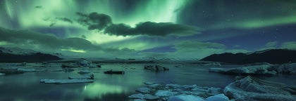
Excursions Randonnées et Treks
Choisissez parmi la plus grande sélection de randonnée et de treks en Islande. Explorez des régions sauvages et admirez des merveilles naturelles époustouflantes.
Trouvez une expérience exceptionnelle
Sélectionnez un lieu de départ
Sélectionnez vos dates
Date de débutDate de fin
Ajouter des voyageurs
1 voyageur
Excursions Randonnées et Treks
Affinez les résultats à l'aide des filtres
Trier par: Populaire


Nous offrons bien plus
Explorez un choix inégalé de circuits et de séjours
Foire aux Questions
Quelle est la meilleure excursion de randonnée en Islande ?
La meilleure randonnée d'une journée en Islande est une randonnée glaciaire de 3,5 heures sur le glacier Vatnajokull. Cette excursion est notée en moyenne 4,8 étoiles sur 5 dans plus de 300 commentaires. Elle coûte environ 137 USD par personne.
Une autre excellente randonnée en Islande est la randonnée de 12 heures au volcan Litli-Hrutur, qui comprend également une visite de la péninsule de Reykjanes. Cette randonnée est notée 4,7 étoiles par plus de 20 commentaires et coûte environ 110 USD par personne.
Quelle est l'excursion de randonnée la moins chère en Islande ?
L'excursion de randonnée la moins chère en Islande est une excursion de randonnée et d'observation des macareux sur la côte sud de l'Islande. Elle coûte environ 72 USD par personne et dure environ 90 minutes. C'est un choix parfait pour les amateurs de nature qui veulent voir les oiseaux les plus célèbres d'Islande.
Quel est l'excursion trek la moins chère en Islande ?
Le trek de plusieurs jours le moins cher en Islande est un trek de quatre jours du mont Hekla à Landmannalaugar. Il coûte environ 1 006 USD par personne, y compris le transfert de Reykjavik au point de départ de la randonnée, l'hébergement dans des refuges de montagne et les repas.
Les randonnées en Islande en valent-elles la peine ?
Oui, les treks en Islande valent vraiment la peine pour ceux qui recherchent une expérience d'aventure et unique en plein air. Ces excursions permettent d'explorer les paysages époustouflants de l'Islande, notamment ses zones géothermiques, ses vallées luxuriantes et ses montagnes couvertes de glaciers. Avec des options pour tous les niveaux de compétence, des promenades tranquilles aux randonnées difficiles, ces circuits constituent une façon mémorable de s'immerger dans la beauté naturelle de l'Islande.
En outre, les visites guidées bénéficient de l'expertise de guides compétents, qui enrichissent l'expérience en donnant un aperçu de la géologie, de la flore et de la faune locales.
Est-il dangereux de faire de la randonnée en Islande ?
Oui, les randonnées en Islande sont généralement sans danger, surtout lorsqu'elles sont accompagnées d'un guide expérimenté. Les guides veillent à ce que vous restiez sur les sentiers balisés et à ce que vous restiez attentifs aux changements de conditions météorologiques. Si vous prévoyez de randonner seul, emportez toujours une carte et une trousse de premiers secours, et n'oubliez pas d'informer quelqu'un de l'itinéraire que vous comptez suivre.
Quels sont les meilleurs sentiers de randonnée en Islande ?
Les meilleurs itinéraires de randonnée en Islande comprennent le sentier Laugavegur, connu pour ses montagnes de rhyolite colorées et ses paysages variés, et le sentier Fimmvorduhals, qui offre des vues imprenables sur les glaciers et les paysages volcaniques.
Parmi les autres sentiers magnifiques, citons le sentier Viknaslodir, dans l'est de l'Islande, qui offre des fjords et des montagnes pittoresques, et les divers sentiers du parc national du Vatnajokull.
Peut-on randonner toute l’année dans les Hautes Terres islandaises ?
Non, les Hautes-Terres deviennent extrêmement froides en hiver, avec des tempêtes de neige et des conditions glaciales qui les rendent inaccessibles. Les Hautes-Terres ne sont accessibles qu'en été.
Quel type de vêtements doit-on porter lors d’une randonnée en Islande ?
Nous recommandons de porter plusieurs couches de vêtements que vous pouvez mettre ou enlever en fonction des températures. Portez des vêtements chauds de type polaire ou laine mais également des vêtements imperméables, coupe-vent et de bonnes chaussures de randonnée. Nous déconseillons de porter du coton qui a des capacités d’isolation limitées et qui met du temps à sécher une fois mouillé. Si vous campez, prenez un sac de couchage, une tente solide et un matelas gonflable. La météo en Islande change rapidement, il est donc essentiel d'être préparé avec de nombreuses épaisseurs.
Est-ce que des baskets suffisent pour une randonnée en Islande ?
Non, il est déconseillé de porter des chaussures de sport ou des baskets en Islande. Le terrain islandais est souvent rocailleux et accidenté. Il est donc recommandé de porter des chaussures de randonnée robustes avec un support pour les chevilles.
Y a-t-il des itinéraires de randonnée près de Reykjavik à faire en une journée ou une demi-journée ?
Oui, il existe un grand choix de randonnée à faire dans la région qui entoure Reykjavik. Heidmork, par exemple, est une réserve naturelle juste à la sortie de la capitale qui offre de nombreux sentiers de randonnée. De nombreuses petites montagnes sont proches de Reykjavik, comme par exemple le Mont Mosfell, le Mont Helgafell, le Mont Keilir, et le Mont Esja.
Qu’est-ce que le trek Laugavegur ?
Laugavegur est le sentier de randonnée le plus populaire d'Islande. Il s'étend sur 55 kilomètres entre Landmannalaugar et la vallée de Thorsmork. Il partage également son nom avec la rue commerçante la plus fréquentée de Reykjavik. Le sentier de randonnée comporte des refuges où les randonneurs peuvent dormir, ainsi que des campings. La plupart des randonneurs mettent trois ou quatre jours pour parcourir l'ensemble de l'itinéraire de Laugavegur.
Qu’est-ce que le trek Fimmvorduhals ?
Fimmvorduhals est un segment de 22 kilomètres du sentier Laugavegur, dans le sud de l'Islande. L'itinéraire comprend une ascension de plus de 1 000 mètres, ce qui signifie qu'il nécessite un bon niveau de forme physique. Si vous empruntez ce sentier, vous serez récompensé par des vues imprenables sur les glaciers Eyjafjallajokull et Myrdalsjokull.
Quelles autres régions d'Islande sont populaires pour faire de la randonnée, en-dehors de Laugavegurinn et Fimmvorduhals ?
Il existe des sentiers de randonnée dans toute l'Islande, dont le niveau de difficulté varie. Kerlingarfjoll et Hveradalir sont des itinéraires de randonnée populaires dans les Hautes-Terres. Dans les Fjords de l'Ouest, les sentiers de randonnée les plus remarquables se trouvent dans la réserve naturelle du Hornstrandir.
Faut-il réserver une place dans les cabanes dans les Hautes-Terres, ou je peux juste arriver sans réservation ?
La plupart des refuges des Hautes Terres d'Islande sont de petite taille, ce qui signifie qu'ils peuvent être complets. Il est donc fortement recommandé de réserver votre place à l'avance pour être sûr d'avoir un lit pour la nuit pendant votre randonnée de plusieurs jours. Vous pouvez également réserver un circuit organisé avec un guide, qui s'occupera de votre hébergement.
Puis-je louer du matériel de randonnée en Islande ?
Oui, vous pouvez louer du matériel de randonnée et de camping, notamment des chaussures de randonnée robustes et des vêtements imperméables. Certains voyagistes proposent également la location d'équipement moyennant un supplément, mais il convient de vérifier au moment de la réservation.


Installez la plus grande plateforme de voyage d'Islande
Téléchargez la plus grande plateforme de voyage d'Islande sur votre téléphone pour gérer l'intégralité de votre voyage au même endroit
Scannez ce code QR avec l'appareil photo de votre téléphone, et cliquez sur le lien apparaissant pour avoir la plus grande plateforme de voyage d'Islande à portée de main. Ajoutez votre numéro de téléphone ou votre adresse e-mail pour recevoir un SMS ou un e-mail avec le lien de téléchargement.