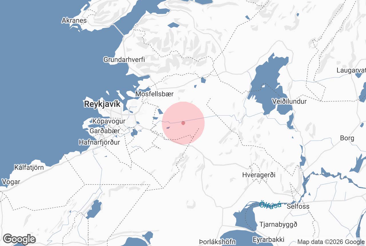
Miðdalsheiði is a low, lake-dotted heath on the eastern edge of the Reykjavík capital area, roughly 20 kilometres from the city centre.
It lies between Þingvallavegur (Route 36) to the north and the Ring Road over Hellisheiði (Route 1) to the south, and forms the western, lower shoulder of the much larger Mosfellsheiði plateau.
The name means "heath of Miðdalur" (mið = middle, dalur = valley, heiði = heath), after the old farm of Miðdalur in Mosfellsbær whose land it was.
Its best-known feature is the lake Selvatn, from which the Gudduós stream runs into the river Hólmsá and on down to Elliðavatn. Guide to Iceland's buggy tour from Úlfarsárdalur crosses the heath on its way towards Mosfellsheiði and Hellisheiði.
Key Takeaways About Miðdalsheiði
- Low heath on the eastern edge of the capital area, between Route 36 (Þingvallavegur) and Route 1 over Hellisheiði; the western shoulder of Mosfellsheiði.
- Selvatn, its largest lake (0.37 km², 131 m above sea level), holds Arctic char and the occasional brown trout; fishing by permit.
- Fault fissures west of Lyklafell and cairned old routes from Elliðakot towards Kolviðarhóll and Þingvellir.
- No car park or signed entrance; reached from farm roads off Route 36 or the track from Lækjarbotnar on Route 1; tracks are gravel.
- Crossed by Guide to Iceland's 2-hour buggy tour, which fords Hólmsá at Gudduós.
Why visit Miðdalsheiði
Miðdalsheiði is not a place you drive to for a single viewpoint. It is open moorland of moss, heather, lava and small lakes that you move through, which is why it suits buggies, mountain bikes, horses and walkers, and it begins a short drive from the city's eastern suburbs.
The heath has several lakes. Selvatn is the largest, 0.37 square kilometres in area, around 40 metres deep at its deepest and 131 metres above sea level.
It holds Arctic char and the occasional brown trout and is a fishing lake for Reykjavík anglers. Smaller lakes nearby include Silungatjörn and Leirtjörn. Water from Selvatn leaves through the Gudduós stream, joins Hólmsá and ends up in Elliðavatn.
The ground tells the story of the rift zone this heath sits on.
A line of faults and open fissures runs through Miðdalsheiði, most visibly just west of the hill Lyklafell, where there are several gaping cracks; the same fracture system runs south through Selfjall and Sandfell.
The heath's western rim, Elliðakotsbrúnir, is a line of escarpments above Nátthagavatn and the old Elliðakot farm site.
Miðdalsheiði carried one of the old routes east from Reykjavík. The old route from the farm Elliðakot ran across the heath past Selvatn and along Lyklafell to the waystation at Kolviðarhóll below Hellisheiði, or branched north-east towards Þingvallavatn (the Dyravegur).
When a proper road east was planned around 1880, there was a dispute over whether to build it here or on the southern line that Route 1 follows today. Cairns from the old routes still stand, and the ruins of two long-abandoned crofts, Sólheimakot and Búrfellskot, are recorded on the heath in an 1855 parish description.
How to get to Miðdalsheiði
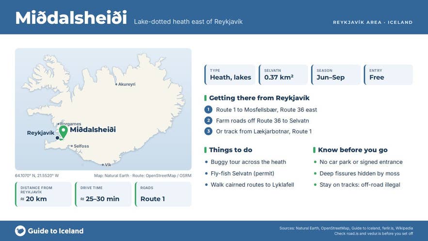
Miðdalsheiði is about 20 kilometres east of central Reykjavík. There is no single car park or signposted entrance; the heath is reached from the roads that frame it.
- From the north: take Route 1 towards Mosfellsbær, then Route 36 (Þingvallavegur) east. The road passes the farm Miðdalur and climbs onto the heath; the farm roads and tracks south of Route 36 lead towards Selvatn.
- From the south: take Route 1 east towards Hveragerði. Near Lækjarbotnar, just past the junction for Heiðmörk, a gravel track leads north-east past the old Elliðakot farm site onto the heath; this is the start of the old Dyravegur route.
- Guide to Iceland's buggy tour starts at Lambhagavegur 13 in the Úlfarsárdalur district and crosses onto the heath over Hólmsá at Gudduós.
The tracks are gravel and in places rough; a normal car can reach the farm roads off Route 36, but beyond that it is better on foot, by bike or in a high-clearance vehicle, and some tracks cross private farmland.
Driving off the tracks is illegal and the moss takes decades to recover. Lyklafell is 5-7 km on foot from the Lækjarbotnar end (about 5.5 km in a straight line from the Elliðakot farm site).
Best time to visit
June to September is the easiest period: tracks are dry, the lakes are ice-free, and the trout and char season is open (fishing permits for Selvatn are sold separately; check the current seller before you go).
Late August and September bring colour to the heather. In winter the heath is often snow-covered and the tracks are not cleared; weather on the open heath changes fast and whiteouts are possible.
Safety and practical tips
- There are no facilities on the heath. The nearest services are in Mosfellsbær and at the Litla kaffistofan café on Route 1.
- Bring a windproof layer; it is colder and windier than in town.
- Watch your footing around the fault fissures west of Lyklafell; some are deep and partly hidden by moss.
- Stay on tracks when driving. Off-road driving carries heavy fines.
Is Miðdalsheiði the same as Mosfellsheiði?
Can I fish in Selvatn?
What is Gudduós?
Is there anything to see for a non-fishing visitor?
Nearby attractions
- Hellisheiði - 5 km, the geothermal plateau the Ring Road crosses, with Iceland's largest geothermal power station.
- Hafravatn - 6 km, a lake below Miðdalsheiði's northern edge with a walking path around it.
- Mosfellsheiði - 6 km, the high heath between Esja and Hengill that Miðdalsheiði leads up to.
- Vífilsfell - 6 km, the 655 m peak overlooking Sandskeið and the Ring Road, a popular half-day hike.
- Rauðhólar - 10 km, red pseudocrater cluster near Elliðavatn.
- Elliðavatn - 11 km, the lake that Hólmsá flows into, at the edge of Heiðmörk.
- Heiðmörk - 11 km, Reykjavík's forested recreation area.
Tours that visit Miðdalsheiði
- 2-Hour Buggy Tour with Burger Stop Near Reykjavik - starts at Lambhagavegur 13, crosses Hólmsá at Gudduós on Miðdalsheiði, continues over Mosfellsheiði (410 m) and the Hengill area towards Hellisheiði, and ends with a burger at the food market in Hveragerði.