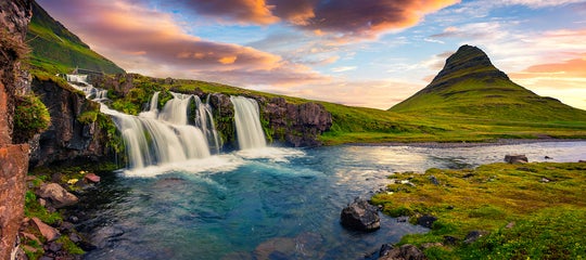
Iceland sits on the Mid-Atlantic Ridge, the boundary between two of Earth's largest tectonic plates. This makes it the only country on Earth where the ridge rises above the ocean surface. The result is one of the most geologically dramatic landscapes on the planet.
From erupting volcanoes and black sand beaches to steaming geysers and crystal-clear fissures, Iceland's terrain is a direct product of the plates pulling apart beneath it. No other destination offers such visible, accessible evidence of our planet's restless geology.
Why You Can Trust Our Content
Guide to Iceland is the most trusted travel platform in Iceland, helping millions of visitors each year. All our content is written and reviewed by local experts who are deeply familiar with Iceland. You can count on us for accurate, up-to-date, and trustworthy travel advice.
The best way to witness Iceland's tectonic wonders is to book a guided volcano tour, where expert guides take you to the most dramatic sites. You can also rent a car in Iceland and drive the Ring Road at your own pace.
For a structured experience, browse Iceland self-drive tour packages that include geological highlights like Thingvellir National Park and the Golden Circle. Find accommodation in Iceland along the route to complete your trip.
Keep reading to learn how Iceland's tectonic plates work, what effects they have on the landscape, and exactly where to go to experience this geological wonder for yourself.
Key Facts About Tectonic Plates in Iceland
-
Iceland is the only country on Earth that sits directly on the Mid-Atlantic Ridge, the boundary between the North American and Eurasian plates.
-
The two plates separate at roughly 2.5 centimeters (1 inch) per year, continuously reshaping Iceland's landscape.
-
Iceland has around 130 active and inactive volcanoes, all driven by tectonic activity beneath the surface. Learn more about volcanic eruptions in Iceland.
-
Over 90% of Icelandic homes are heated using geothermal energy produced by the same tectonic forces.
-
Thingvellir National Park is the best place to walk between two tectonic plates above ground and is a UNESCO World Heritage Site.
-
Silfra is the only place in the world where you can snorkel or dive between two tectonic plates, with visibility exceeding 100 meters (330 feet).
-
The Bridge Between Continents on the Reykjanes Peninsula offers a free and accessible way to stand on the Mid-Atlantic Ridge.
-
Surtsey, a volcanic island that rose from the ocean between 1963 and 1967, is one of the best examples of how tectonic activity creates new land.
The Mid-Atlantic Ridge and Iceland's Tectonic Plates
 The Earth's outer layer is divided into seven major tectonic plates that are constantly moving. Where plates pull apart, magma rises from below to fill the gap, cooling into new oceanic crust over millions of years.
Two of the largest are the North American and Eurasian plates. The boundary between them is the Mid-Atlantic Ridge, a massive underwater mountain range stretching along the floor of the Atlantic Ocean.
If you have ever wondered where Iceland is located, it sits in the North Atlantic Ocean, just below the Arctic Circle. It is also the only country on Earth that sits directly on the Mid-Atlantic Ridge.
It began forming around 60 million years ago as the two plates separated, with volcanic eruptions building layer upon layer of lava above the ocean surface.
The ridge runs through Iceland from southwest to northeast. Some parts of the country sit on the North American plate, while others rest on the Eurasian plate, meaning Iceland quite literally straddles two continents at once.
The plates continue pulling apart at roughly 2.5 centimeters (1 inch) per year. This ongoing movement drives Iceland's volcanic eruptions, earthquakes, and geothermal energy, making it one of the most geologically active countries on Earth
Effects of Tectonic Plates on Iceland

Photo from Wikimedia, Creative Commons, by M. Bitton.
Iceland's tectonic activity shapes everything from its volcanoes and earthquakes to its geothermal hot springs and brand new islands. Here is a closer look at the three biggest effects of the shifting plates on Iceland's landscape.
Volcanic Eruptions and Earthquakes

As the two plates pull apart, magma rises through the resulting fissures. This drives the frequent volcanic eruptions in Iceland that have shaped the country's dramatic landscape for millions of years.
Iceland is home to around 130 active and inactive volcanoes. The most internationally recognized is Eyjafjallajokull, which erupted in 2010 and sent a cloud of volcanic ash across European airspace, disrupting air travel for weeks.
Some eruptions have had devastating consequences for local communities. A 1973 eruption in the Westman Islands came without warning and destroyed hundreds of homes. Thankfully, the island's residents were evacuated safely before the lava reached the town.
A series of eruptions beginning in 2021 has drawn visitors from around the world, with lava flows close enough to hike to and watch safely. The Reykjanes eruptions have been some of the most accessible and widely watched volcanic events in Iceland's modern history.
The same forces also trigger frequent earthquakes across the country. Most are small and go unnoticed, but larger seismic events do occur. Iceland has strict building codes in place to reduce the impact of earthquake damage.
To learn more, head to Hvolsvollur in South Iceland and book a 1-hour Lava Centre exhibition and cinema tour. It is a fun and interactive way to learn about Iceland's volcanic and earthquake history.
Formation of New Land

Photo from Wikimedia, Creative Commons, by Howell Williams.
The diverging plates also create entirely new land. As magma rises and cools on the surface, it builds up layer by layer until it breaks above the ocean. This is how Iceland itself formed, and the process is still happening today.
The best example is Surtsey, a volcanic island off the south coast of Iceland that rose from the ocean in a series of eruptions between 1963 and 1967. Watching a brand new island form from scratch was a once-in-a-generation event.
Surtsey is closed to visitors to protect its natural development, but scientists have closely monitored it for decades. It has become one of the most valuable natural laboratories on Earth for studying how ecosystems establish themselves on entirely new land.
While you cannot set foot on Surtsey itself, you can see it from the sea on many of the boat tours available from the Westman Islands. It is a worthwhile addition to any trip along Iceland's south coast.
Geothermal Activity

Tectonic activity does more than create volcanoes. The heat generated by magma rising close to the surface powers an extensive geothermal energy system that supplies over 90% of Icelandic homes with heating. Iceland is one of the most sustainably powered countries on Earth.
The Mid-Atlantic Ridge doesn't just split the island at Thingvellir or reveal itself in the clear waters of Silfra. Its presence can be traced across the entire country through the geothermal activity it produces. Wherever the ridge passes beneath Iceland, it leaves the ground warm, the earth restless, and the landscape steaming.
This geothermal energy also fuels some of Iceland's most visited attractions. The Geysir geothermal area is one of the three stops on the famous Golden Circle route. It is home to Strokkur, a geyser that shoots water high into the air every few minutes.
Further south, the town of Hveragerdi sits directly on top of a geothermal field. Locals use the heat to power greenhouses, and the nearby Reykjadalur Valley is a popular spot for a hike to a naturally heated river where you can bathe.
 The Blue Lagoon on the Reykjanes Peninsula is Iceland's most famous geothermal attraction. It is known for its striking mineral-rich waters and world-class spa facilities. For something more remote, Landmannalaugar offers natural hot spring baths surrounded by colorful rhyolite mountains.
No visit to Iceland is complete without a soak in geothermally heated water. Browse the best hot spring tours in Iceland to find the right experience for your trip.
Where to See the Tectonic Plates in Iceland
 Most of the Mid-Atlantic Ridge lies underwater, so it is not easy to see for yourself. However, Iceland's unique position on the ridge means there are several places where you can witness this geological phenomenon up close.
Thingvellir National Park
 Thingvellir National Park is one of Iceland's most iconic destinations and one of the best places to see the tectonic plates in Iceland. It forms one of the three stops on the popular Golden Circle route.
The rift between the two plates is clearly visible in the gorge of Almannagja. This dramatic fissure was formed as the North American and Eurasian plates slowly pulled apart. Walking through it means you are physically passing between two continents.
 Thingvellir is also where Iceland's first parliament, the Althingi, was founded around 930 AD. It is considered one of the oldest parliamentary institutions in the world and the Icelandic parliament still carries the same name today.
In recognition of its geological and cultural significance, Thingvellir was designated a UNESCO World Heritage Site. The best way to visit is on a Golden Circle small group tour, where a local guide brings the history and geology to life.
Visitor information:
-
Thingvellir is open year-round and accessible in all seasons, though winter visits require care on icy paths.
-
The park is located about 45 minutes by car from Reykjavik, making it an easy day trip.
-
Most visitors spend two to three hours here, though the park is large enough to reward a longer visit.
-
Entrance to the park is free, though there is a parking fee at the main lot.
Silfra Fissure

The Silfra fissure sits within Thingvellir National Park and is the only place in the world where you can snorkel or dive in Iceland between two tectonic plates. It is widely considered one of the best dive sites on the planet.
The water in Silfra is glacial meltwater that has been naturally filtered through porous volcanic rock over several decades. By the time it reaches the fissure, it is among the clearest water found anywhere on Earth, with visibility that regularly exceeds 100 meters (330 feet).
The water temperature hovers between 2 to 4 C (35 to 39 F) year round. That sounds daunting, but drysuits keep you warm and dry throughout the experience. Another remarkable detail is that the water in Silfra is clean enough to drink directly as you swim through it.
As you float through the fissure, you are struck by the realization that you are drifting between two continents. Every dive or snorkel here is a unique experience, as the fissure is continuously reshaped by the Earth's restless geology.
While Silfra's cold waters might seem off-putting, there are very accessible ways to experience it. Booking a snorkeling tour in Silfra requires no prior diving certification, making it suitable for most visitors. A drysuit is provided, keeping you comfortably warm throughout.
Visitor information:
-
Snorkeling and diving tours at Silfra run year-round, including in winter.
-
Tours depart from the Silfra parking area inside Thingvellir National Park.
-
Snorkeling requires no prior certification; scuba diving tours typically require an Open Water certification and prior cold water experience.
-
A standard snorkeling tour lasts around three hours in total, with roughly 30 to 45 minutes spent in the water.
-
Minimum age and weight requirements apply, and participants must be able to swim.
Bridge Between Continents
 The Reykjanes Peninsula in southwestern Iceland lies directly on the Mid-Atlantic Ridge and offers a vivid showcase of what tectonic activity looks like above ground. The region is filled with volcanic craters, steaming vents, and lava fields shaped by centuries of geological activity.
The Bridge Between Continents is a footbridge that spans a small fissure marking the general boundary between the North American and Eurasian plates. While it is more symbolic than a precise scientific marker, it gives visitors a tangible way to experience standing between two continents.
The fissure beneath the bridge has been slowly widening as the plates continue to separate at roughly 2.5 centimeters (1 inch) per year. Over time, this gradual movement has created the visible rifts and valleys that define the Reykjanes landscape today.
Standing on the bridge, you get a real sense of the dynamic nature of the Earth's crust. The boundary between the plates is not just a concept here. It is a physical reality you can see and stand on with your own feet.
The Bridge Between Continents is free to visit and just a short detour from the main road. It makes for an easy and rewarding stop on any trip around the peninsula. Check out our guide to the 22 things to do in Reykjanes Peninsula to make the most of your time in the area.
Experience the Tectonic Plates in Iceland for Yourself
 Iceland's tectonic landscape is unlike anything else on Earth. The rift at Thingvellir, the crystal-clear waters of Silfra, and the Bridge Between Continents are all living proof of the extraordinary forces shaping this island every single day.
There is no better way to experience it all than on one of the many Iceland vacation packages that take you through the country's most dramatic landscapes. To learn more about what lies beneath the surface, our guide to the geology of Iceland is a great place to start.
No matter how you choose to explore, Iceland's tectonic wonders promise views, experiences, and memories that will stay with you long after you leave.
Can you walk between the tectonic plates in Iceland?
Can you touch two tectonic plates in Iceland?
How many tectonic plates are there in Iceland?
Why is Iceland so tectonically active?
What is the tectonic plate boundary in Iceland?
Which part of Iceland is on which tectonic plate?
Where is the best place to see tectonic plates in Iceland?
How deep is the Silfra fissure?
Is it safe to visit volcanic areas in Iceland?
How old is Iceland geologically?
What causes geothermal activity in Iceland?
Have you ever walked between two tectonic plates or dived at Silfra? Which of these geological wonders is on your Iceland bucket list? We would love to hear about your experience in the comments below!

Hi, I’m Arnar Tómas, a storyteller with a background in journalism and content creation. I’ve worked with top Icelandic media and travel organizations, and I’m into fantasy football, pro wrestling, and travel.