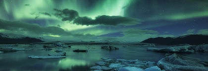
Excursions Grottes de Glace
Parcourez la plus grande sélection de visite de grottes de glace en Islande. Admirez les magnifiques couleurs bleues et les motifs hypnotiques de la glace, à l'intérieur d'un glacier.
Trouvez une expérience exceptionnelle
Sélectionnez un lieu de départ
Sélectionnez vos dates
Date de débutDate de fin
Ajouter des voyageurs
1 voyageur
Vous ne savez pas par où commencer ? Consultez Le Guide Ultime des Grottes de Glace en Islande
Excursions Grottes de Glace
Affinez les résultats à l'aide des filtres
Trier par: Populaire


Nous offrons bien plus
Explorez un choix inégalé de circuits et de séjours
Foire aux Questions
Quelle est la meilleure visite de la grotte de glace cette année ?
Durant cette saison, deux incroyables grottes de glace du glacier Vatnajokull sont ouvertes à la visite : la Grotte de glace de l'Ouest et la Grotte de glace de l'Est.
Cette visite des grottes de glace incontournable vous emmène dans la meilleure grotte accessible chaque jour, offrant une expérience inoubliable dans la paisible Grotte de glace de l'Ouest ou la saisissante Grotte de glace de l'Est. La Grotte de glace de l'Ouest, avec ses parois bleues scintillantes, donne l'impression de pénétrer dans un diamant étincelant. Sa situation isolée la rend plus exclusive et idéale pour des photos tranquilles et à couper le souffle. La Grotte de glace de l'Est, plus spacieuse et accessible, séduit par ses couleurs vibrantes et ses formations spectaculaires, offrant une expérience inoubliable.
Les deux grottes promettent un voyage envoûtant dans les merveilles glacées de l'Islande.
Quelle est la visite de grotte de glace la moins chère d’Islande ?
La visite de grotte de glace la moins chère en Islande est proposée à partir d’environ 140 EUR. C'est une visite en petit groupe d'une durée de 4 heures qui commence au centre d'accueil des visiteurs de Skaftafell et vous emmène au glacier Vatnajokull. Là, vous ferez à la fois l'expérience de l'exploration de grotte glaciaire et celle de la randonnée sur glacier. Le centre d'accueil de Skaftafell se trouve à approximativement 4 heures de route de Reykjavik.
Quelles sont les meilleures excursions dans les grottes de glace au départ de Reykjavik ?
Les meilleures excursions dans les grottes de glace au départ de Reykjavik comprennent l'impressionnante visite de la grotte de glace de Katla, près de Vík, connue pour son étonnante glace noire, et l'emblématique visite de la grotte de glace de Langjokull, un tunnel creusé par l'homme à l'intérieur d'un glacier.
Pour une aventure complète, participez à ce circuit de trois jours qui combine une grotte de glace avec les points forts du Cercle d'or et de la Côte Sud.
Quelle est la meilleure visite de grotte de glace en Islande ?
La meilleure excursion d'une journée dans une grotte de glace est celle qui commence à la lagune du glacier de Jokulsarlon. Notre circuit de plusieurs jours le plus populaire avec spéléologie est ce circuit de 2 jours vers la lagune glaciaire de Jokulsarlon, ainsi que ce circuit de 3 jours sur la Côte Sud, incluant le Cercle d'Or.
La visite de grotte de glace la plus populaire en Islande est une excursion de 5 jours pour visiter la grotte de glace bleue du Parc National de Vatnajokull, qui inclut aussi les sites de la Côte Sud, ceux du célèbre Cercle d'or, et une baignade au Blue Lagoon.
Puis-je visiter des grottes de glace en été ?
Les grottes de glace sont généralement plus stables et plus sûres pendant les mois d'hiver. La grotte de glace de Katla et le tunnel du glacier Langjokull sont les seules à être accessibles en été. Il est conseillé de toujours participer à une excursion guidée et de consulter des experts locaux avant de visiter des grottes de glace en été.
Peut-on visiter des grottes de glace en Islande vers la fin octobre ?
Certaines grottes de glace en Islande sont encore ouvertes à la fin du mois d'octobre, mais cela dépend des conditions météorologiques chaque année. La grotte de glace de Katla est cependant ouverte toute l'année.
Les excursions dans les grottes de glace en Islande sont-elles possibles à Noël ?
Dans le glacier Vatnajokull en Islande, les visites de grottes de glace sont disponibles d'octobre à mars, y compris autour de Noël. La plupart des opérateurs proposent des visites dans la période de Noël.
Des excursions en motoneige et dans les grottes de glace sont-elles possibles en Islande ?
Oui, il existe plusieurs excursions en motoneige et dans des grottes de glace en Islande, comme cette incroyable excursion de 4 heures en motoneige et dans des grottes de glace sur le glacier Langjokull.
Proposez-vous des excursions photo dans des grottes de glace en Islande ?
Oui, nous proposons des excursions photographiques en Islande, comme cette excursion de 3 heures en petit groupe dans une grotte de glace, avec un forfait photo professionnel.
Puis-je faire une visite privée des grottes de glace?
Oui, vous pouvez tout à fait réserver une visite privée des grottes de glace en Islande, comme cette visite privée dans une grotte de glace de cinq heures en hiver. Ces visites offrent souvent une expérience plus personnalisée et peuvent être adaptées à vos préférences et à vos besoins.
Les excursions dans les grottes de glace sont-elles adaptées aux personnes âgées ?
Les excursions dans les grottes de glace peuvent être adaptées aux personnes âgées, en fonction de leur niveau de forme physique et de la difficulté de l'excursion. Certaines excursions comportent de courtes marches sur terrain plat, tandis que d'autres nécessitent des randonnées ou de l'escalade plus ardues. Une excellente option pour les personnes âgées est de participer à une excursion dans une grotte de glace, avec les cascades de Hraunfossar, au départ de Reykjavik.
Les excursions dans les grottes de glace en Islande sont-elles adaptées aux enfants?
De nombreux circuits dans les grottes de glace en Islande sont adaptés aux familles, mais les restrictions d'âge peuvent varier d'un circuit à l'autre. Pour des raisons de sécurité, certains circuits n'autorisent les enfants qu'à partir d'un certain âge, il est donc préférable de vérifier l'âge minimum pour chaque circuit. L'une des meilleures excursions dans les grottes de glace pour les familles avec enfants est l'excursion classique Into the Glacier ("À l'Intérieur du Glacier") qui n'impose aucune restriction d'âge.
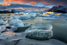
Où puis-je voir une grotte de glace bleue cristal en Islande ?
Vous pouvez voir une grotte de glace bleu cristal en Islande sous le glacier Vatnajokull, accessible lors de visites guidées depuis la lagune glaciaire de Jokulsarlon, comme la meilleure visite de grotte de glace en Islande. Cette dernière vous emmène dans la plus belle et la meilleure grotte de glace disponible durant la saison d'hiver 2024-2025 : la Grotte de glace de l'Ouest ou celle de l'Est, dans le vaste glacier Vatnajokull.
Quelle est la différence entre les visites de grottes de glace et les visites de grottes de glacier en Islande ?
Les excursions dans les grottes de glace et les grottes de glacier en Islande offrent des expériences uniques, mais il existe des différences essentielles entre les deux :
- Les excursions dans les grottes de glace se concentrent sur les grottes naturelles situées à l'intérieur des glaciers, où vous verrez de l'impressionnante glace bleue, formée par la fonte et le regel. Elles sont généralement accessibles en hiver, lorsque la glace est stable, avec des sites populaires tels que le Vatnajokull et la grotte de glace de Katla, ouverte toute l'année, près de Vik.
- Les excursions dans les grottes de glacier peuvent inclure des grottes naturelles et artificielles, comme celle du tunnel de glace artificiel du glacier Langjokull, ouvert toute l'année.
La principale différence est que les visites grottes de glace sont souvent saisonnières et naturelles, tandis que les visites de grottes de glacier peuvent être visités toute l'année et peuvent inclure des éléments artificiels. Les deux types d'excursions offrent des moyens uniques d'explorer les merveilles gelées de l'Islande.
Quelle est la meilleure période de l'année pour visiter les grottes de glace en Islande ?
La haute saison pour les visites de grottes de glace s'étend de novembre à mars, lorsque la glace est la plus stable. C'est durant cette période qu'a lieu cette incroyable visite de grotte de glace , qui vous emmène dans une grotte bleue cristalline dans le glacier Vatnajokull.
D'autres grottes, comme celles de Langjokull et de Katla, sont accessibles toute l'année en raison de constructions humaines ou de conditions géologiques spécifiques.
Peut-on visiter des grottes de glace par soi-même en Islande ?
Non. Il ne faut jamais visiter une grotte de glace en Islande sans un guide professionnel, car cela peut être dangereux.
Combien de temps dure une excursion spécial grotte de glace en Islande ?
Votre visite à l'intérieur de la grotte de glace durera environ 45-60 minutes. Cependant, selon l'excursion choisie, la durée totale de l'excursion dure le plus souvent 4 ou 5 heures, car cela prend du temps de s'équiper et de randonner vers la grotte de glace elle-même ; elles sont souvent situées à l'intérieur de glaciers.
Comment se forment les grottes de glace en Islande ?
Les grottes de glace en Islande se forment lorsque l'eau de fonte en été s'écoule dans un glacier par des fissures et trouve ensuite son chemin vers l'extérieur. La plupart des visites de grottes de glace en Islande ne sont possibles qu'en hiver, lorsque les grottes sont plus stables.
Où puis-je trouver des grottes de glace en Islande?
Les grottes de glace d'Islande se trouvent dans toute l'île, mais certaines des plus populaires et des plus accessibles sont situées dans le Parc national du Vatnajokull, près de la lagune glaciaire de Jokulsarlon. D'autres grottes de glace remarquables se trouvent dans le glacier Langjokull, près du Cercle d'Or, et la grotte de Katla (ouverte toute l'année) se trouve près de la ville méridionale de Vík.
Cela vaut-il le coup de visiter les grottes de glace en Islande ?
Complètement. Il s'agit d'une expérience unique en Islande, qui vous transportera dans un tout autre monde, et que vous n'oublierez jamais. Les opportunités pour prendre des photos sont fantastiques, et comme certaines grottes ne sont accessibles qu'en hiver, cela rend l'expérience encore plus unique.
L'accès aux grottes de glace en Islande est-il sécurisé ?
Toutes les grottes de glace en Islande sont vérifiées au préalable par des guides professionnels et expérimentés pour s'assurer de la solidité de leur structure. Elles ne peuvent être visitées que lors d'excursions pour visiter les grottes de glace, encadrées par un guide local.
Quelle est la meilleure période pour visiter les grottes de glace en Islande?
La meilleure période pour visiter les grottes de glace en Islande est l'hiver, de novembre à mars. Durant cette période, les grottes sont plus stables et accessibles en raison des températures plus froides.
Combien de temps vais-je passer à l'intérieur de la grotte de glace en Islande ?
Au cours de la plupart des visites de grottes de glace en Islande, les participants passent environ 40 ou 50 minutes à l'intérieur de la grotte, pour admirer les parois des glaciers et les formations de glace tout en apprenant plein de choses sur elle.
À quel point fait-il froid dans les grottes de glace en Islande ?
La température à l'intérieur des grottes de glace en Islande est d'environ 0°C et peut atteindre -10°C dans certains endroits. Il est donc important de porter des vêtements chauds, un bonnet et des gants lors de la visite d'une grotte de glace, même en été.
Quels types de formations glaciaires puis-je m'attendre à voir à l'intérieur des grottes ?
À l'intérieur des grottes de glace, vous pouvez rencontrer diverses formations de glace, notamment des stalactites, des cascades gelées et des couches de glace bleue, blanche ou même noire, créées par la compression de la glace et l'incorporation de cendres volcaniques. Les formations et les couleurs varient en fonction de la grotte et de la période de l'année.
À quelle distance se trouvent les grottes de glace de Reykjavik ?
La distance entre Reykjavik et les grottes de glace les plus populaires varie. Par exemple, les grottes de glace du Parc national de Vatnajokull se trouvent à environ 370 km de Reykjavik, soit environ 4,5 heures de route. Certains circuits comprennent le transport depuis Reykjavik ou les villes voisines, tandis que d'autres exigent que vous vous retrouviez à un endroit spécifique plus proche de la grotte, comme à Vík.
Les grottes de glace en Islande ont-elles le même aspect chaque année ?
Non, les grottes de glace en Islande sont principalement des formations naturelles qui changent chaque année en raison de la fonte et du regel. Cela signifie que chaque visite peut offrir une expérience différente, même si vous visitez le même glacier plusieurs fois. Cependant, certaines grottes de glace, comme le tunnel de glace du glacier Langjokull, ont été créées par l'homme et se ressemblent d'une année sur l'autre.
Y aura-t-il de la lumière du jour si nous visitons les grottes de glace en début de journée au milieu de l'hiver ?
Oui, il se peut qu'il vous faille 4 ou 5 heures pour voyager vers les grottes de glace en Islande, si vous arrivez de Reykjavik. Le temps que vous arriviez et que vous enfiliez votre équipement de sécurité, le soleil se sera levé et vous serez prêt(e) pour partir explorer les grottes de glace.
Quels vêtements prévoir pour une visite de grotte de glace ?
Pour les excursions dans les grottes de glace en Islande, il est essentiel de porter des vêtements chauds et imperméables ; notamment une couche de base thermique, une veste isolante et des bottes de randonnée robustes et imperméables, offrant une bonne adhérence. Des gants, un bonnet et une écharpe sont également recommandés, car les conditions à l'intérieur des grottes peuvent être froides et glissantes.
Y aura-t-il besoin d'équipement d'escalade pour visiter les grottes de glace en Islande ?
À moins que la description de votre excursion ne l'indique explicitement, vous n'aurez pas besoin d'outils d'escalade pour explorer les grottes de glace islandaises. Si par contre votre circuit comprend de l'escalade sur glace, cela sera indiqué dans sa description, et l'opérateur vous fournira tout l'équipement nécesssaire.
Les excursions dans les grottes de glace en Islande sont-elles physiquement exigeantes ?
Les exigences physiques pour une excursion dans une grotte de glace peuvent varier de l'une à l'autre. Certaines grottes nécessitent une randonnée sur le glacier, ce qui peut être physiquement éprouvant, alors que d'autres ne nécessitent que de courtes marches. Nous vous conseillons de lire attentivement la description de l'excursion afin de déterminer le niveau de condition physique requis pour celle-ci.
Comment choisir la visite de la grotte de glace qui me convient ?
Lorsque vous choisissez une excursion dans une grotte de glace, tenez compte de facteurs tels que le niveau de difficulté de l'excursion, sa durée, sa localisation et la taille du groupe. Tenez également compte de la période de l'année, de vos intérêts personnels, de votre forme physique et de vos projets de voyage.
Que se passe-t-il si le temps est mauvais le jour de la visite de la grotte de glace?
Si le voyagiste estime que les conditions météorologiques sont trop dangereuses, l'excursion peut être annulée ou reportée à un autre jour. Si l'excursion est annulée en raison du mauvais temps ou reportée à un autre jour et que vous ne pouvez pas vous y rendre, vous serez toujours remboursé en intégralité.
Comment visiter une grotte de glace en Islande?
Pour visiter une grotte de glace en Islande, il faut participer à une excursion guidée. Ces excursions sont menées par des guides expérimentés qui connaissent bien les grottes et les conditions locales. Les visites guidées garantissent votre sécurité et vous fournissent des informations précieuses sur les grottes et leur formation.
Puis-je prendre des photos à l'intérieur des grottes de glace?
Oui, la photographie est généralement autorisée dans les grottes de glace, qui offrent de superbes opportunités de capturer des images uniques et magnifiques. Veillez à vous munir d'un appareil photo adapté aux conditions de faible luminosité et suivez toujours les instructions de votre guide pour des raisons de sécurité et de prévention.
Puis-je utiliser un drone pour filmer la visite d'une grotte de glace ?
L'utilisation de drones est souvent restreinte ou interdite dans de nombreuses zones naturelles en Islande, y compris dans les grottes de glace et leurs environs. Vérifiez toujours avec le guide touristique et suivez les réglementations locales concernant l'utilisation des drones. Dans de nombreux cas, les drones ne sont pas autorisés pour des raisons de sécurité et de perturbations potentielles de l'environnement et de la faune.
Dois-je réserver à l'avance une excursion de grotte de glace?
Il est recommandé de réserver votre excursion dans une grotte de glace à l'avance, en particulier pendant la haute saison d'hiver car les places se remplissent rapidement. En réservant à l'avance, vous êtes sûr d'avoir une place pour l'excursion et vous pouvez planifier votre voyage plus efficacement.
Est-il possible de combiner une visite des grottes de glace avec d'autres activités en Islande?
Oui, de nombreux voyagistes proposent des forfaits combinés qui incluent la visite des grottes de glace avec d'autres activités populaires, telles que la randonnée sur glacier, la motoneige ou la chasse aux aurores boréales. Ces forfaits peuvent constituer un moyen plus complet et plus pratique de découvrir les diverses attractions que l'Islande a à offrir.
Y a-t-il des toilettes dans les grottes de glace?
Les toilettes des grottes de glace sont généralement limitées ou inexistantes. Il est préférable d'utiliser les toilettes avant de commencer l'excursion, soit à la base où vous revêtez votre équipement de glacier, soit dans les installations voisines.
Y a-t-il une taille maximale de groupe pour les visites des grottes de glace ?
La taille maximale des groupes pour les excursions dans les grottes de glace varie d'un organisateur à l'autre et peut dépendre de l'endroit où se trouve la grotte. La taille des groupes peut varier de 8 à plus de 20 participants.
Les grottes de glace sont-elles accessibles aux personnes en fauteuil roulant?
Les grottes de glace en Islande ne sont généralement pas accessibles aux fauteuils roulants, en raison de la difficulté et de l'irrégularité du terrain, ainsi que de la nécessité de naviguer dans des passages étroits ou de grimper dans certains cas.
Si vous avez des problèmes d'accessibilité spécifiques, contactez-nous à l'adresse info@guidetoiceland.is pour discuter des aménagements possibles ou des solutions de rechange.


Installez la plus grande plateforme de voyage d'Islande
Téléchargez la plus grande plateforme de voyage d'Islande sur votre téléphone pour gérer l'intégralité de votre voyage au même endroit
Scannez ce code QR avec l'appareil photo de votre téléphone, et cliquez sur le lien apparaissant pour avoir la plus grande plateforme de voyage d'Islande à portée de main. Ajoutez votre numéro de téléphone ou votre adresse e-mail pour recevoir un SMS ou un e-mail avec le lien de téléchargement.