Informationen über: Fjallabak
Fjallabak may refer to Fjallabak Nature Reserve, or two highland routes, South Fjallabaksleið or the North Fjallbaksleið. The name 'Fjallabak' literally translates to 'The Back of the Mountains', or 'Mountain Back'.
Fjallabak Nature Reserve
Fjallabak Nature Reserve ("Friðland að Fjallabaki") is an area in the Icelandic Highlands surrounding the popular hiking destination of Landmannalaugar, protected since 1979.
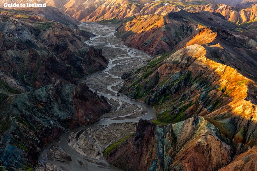
The entire area is more than 500 metres above sea level and characterised by colourful mountains, geothermal valleys and volcanic activity. The colour is due to the rhyolite and obsidian making the ground appear green, blue, pink, red and yellow. Lava fields, rivers and lakes also make their mark on this Nature Reserve.
A popular natural hot spring is located at Landmannalaugar camping ground, where visitors will frequently bathe. A mountain hut is also found in the area, perfect for guests to book overnight stays, use the kitchen and the bathroom facilities.
All amenities are basic and very rustic and there are no food or grocery shops available in the area.
The area is most popular with hikers; to reach it a 4WD car is needed as some rivers need to be crossed. Fjallabak Nature Reserve is also only accessible during summertime, as it is covered with thick ice and snow in wintertime.
Iceland's most popular hiking route, the Laugavegur Route, leads from Landmannalaugar within Fjallabak Nature Reserve to Þórsmörk.
Hikers normally take 3-4 days to hike it.
South Fjallabaksleið
The South Fjallabaksleið ('Fjallabaksleið syðri') is an old highland route north of Mýrdalsjökull glacier, connecting Rangárvellir (the eastern part of the South Iceland lowlands) to Skaftártunga (the area northwest of Mýrdalsjökull).
The area is very dry, sporting scant vegetation as it is situated between mountains that have a strong volcanic activity. The mountains have left endless amounts of ash, sand and lava in the area which is now covered in moss, creating a truly unique regional look.
North Fjallabaksleid
In more recent times, another track, North Fjallabaksleið ('Fjallabaksleið nyrðri'), has been laid, connecting the two aforementioned areas. This north track was originally named Landmannaleið by the local farmers who used it.
Dienstleistungen in der Nähe: Fjallabak
Attraktionen in der Umgebung: Fjallabak
Dómadalur
Domadalur is a valley east of Kringla (Landmannahellir cave) in the south of the Icelandic highlands. The valley has a little shallow lake a...
Landmannaleið
Photo from Wikimedia, Creative Commons, by Pietro Landmannaleið, or the F225, is a highland road that leads to the Fjallabak Nature Reserve and t...
Frostastaðavatn
Frostastaðavatn is a lake in the southern region of the Highlands of Iceland. Its shores are accessible via the Highland routes of the F208 and ...
Ljótipollur
Ljótipollur is an explosion crater and crater lake in the south Highlands. Its name means ‘Ugly Puddle’, despite the fact it is a...
Landmannalaugar
Landmannalaugar, or the 'People's Pools', is a vast area of stunning and unique beauty in the heart of Iceland's southern Highlands....
Brennisteinsalda
Brennisteinsalda (ca. 855 m) is a volcano in the area of Landmannalaugar National Park, in the south highlands of Iceland. Brennisteinsalda ...
Bláhnjúkur
Blahnjukur (a.k.a. Blahnukur) is a volcano in the area of Landmannalaugar, in the south highlands of Iceland. Blahnjukur's name (...
Sigoldugljufur
Sigöldugljúfur, also known as the Valley of Tears, is a canyon in the Icelandic Highlands. It is most renowned for and earned its nickn...
Torfajökull
Torfajökull is the name of both a stratovolcano and a complex of subglacial volcanoes, north of Mýrdalsjökull glacier in South Icelan...
Strútslaug
Strutslaug (also known as Holmsarbotnalaug) is a geothermal pool in the South Highlands, north of Myrdalsjokull glacier and close to Torfajokull glaci...
Veiðivötn
Veiðivötn is an area of over 50 small fishing lakes, situated north-east of Friðland að Fjallabaki and Landmannalaugar. The ov...
Krakatindur
Krakatindur is a 858 m volcano in Rangarvallasysla in South Iceland. The volcano is located in the Nyjahraun lava field and belongs to ...
Stórasúla
Stórasúla is a distinctive, cone-shaped mountain found in the southern highlands of Iceland. The mountain has an elevation of 693 m (2...
Faxi
Credit: Wikimedia, Creative Commons. Photo by Kkaefer. Faxi is a wide, serene waterfall in South Iceland. It can be found in the Tungufljót Ri...
Bláfjöll
Wikimedia, Creative Commons, photo by Reykholt The Blue Mountains, otherwise known as Bláfjöll, are a beautiful mountain range in the sou...
Eldgjá
Eldgjá is the largest volcanic canyon in the world, located in the south of Iceland. Wikimedia, Creative Commons, Photo by Ilya Grigorik ...
Hekla
Hekla, nicknamed ‘the Gateway to Hell’ in the Middle Ages, is one of Iceland’s most explosive, unpredictable and powerful volcanoes....
Laugavegur (Wanderweg)
Laugavegur is one of the most popular highland trails in Iceland. The scenery is breathtaking in its beauty and diversity, perfectly representing th...
Hólaskógur
Holaskogur is an deforested area (despite the name, 'skogur'='forrest') in Gjupverjaafrettur in the mid highlands of Iceland.&...
Háifoss
Háifoss, or the 'High Waterfall', is a waterfall in Fossárdalur valley, innermost of Þjórsárdalur valley, ...