Begrenzt verfügbar
Buche jetzt & spare Geld
Bestpreisgarantie
Keine Buchungsgebühren
3-tägiger Fotoworkshop | Vatnajökull-Nationalpark
Schließe dich diesem spannenden, 3-tägigen Foto-Workshop an und halte viele der schönsten Attraktionen an Islands Südküste und im größten Nationalpark des Landes, Vatnajökull, digital fest. Diese Tour ist eine großartige Option für alle Fotografen, die nach Island reisen, um an ihren Fähigkeiten zu feilen und dabei so viele Sehenswürdigkeiten wie möglich in kurzer Zeit zu besuchen.
Mit seinen unzähligen, atemberaubenden Naturattraktionen ist Island wie zum Fotografieren geschaffen. Nach diesem Workshop ist deine Fotomappe randvoll mit fantastischen Aufnahmen aus diesen drei Tagen im Schatten von Europas größtem Gletscher.
Worauf wartest du? Sichere dir gleich deinen Platz in diesem 3-tägigen Workshop und bringe deine Fähigkeiten als Fotograf aufs nächste Level. Wähle jetzt ein Datum aus, um die Verfügbarkeit zu überprüfen.
Kurzinfo
- Verfügbarkeit: Jun. - Aug.
- Dauer: 3 Tage
- Aktivitäten: Wanderung, Besichtigung, Kultur-Tour
- Schwierigkeitsstufe: Einfach
- Mindestalter: 18 Jahre
- Sprachen: English
- Höhepunkte: Jökulsárlón,
Jökulsárlón is Iceland’s most famous glacier lagoon. Conveniently located in the southeast by Route 1, about halfway between the Skaftafell Nature Reserve and Höfn, it is a popular stop for those travelling along the South Coast or around the Ring Road of the country.
Geography
As a glacier lagoon, Jökulsárlón is a lake that is filled with the meltwater from an outlet glacier. In this case, it is Breiðamerkurjökull, a tongue of Europe’s largest ice cap, Vatnajökull.
It stands out, however, due to the fact that it also fills with icebergs breaking from the glacier, some of which tower several stories high.
These icebergs, other than their scale, are notable for their colouration. Although they are, as expected, largely white, most are also dyed electric blue in part, with black streaks of ash from eruptions centuries past.
When the icebergs finally make it across the lagoon, they either drift out to sea or wash up on the nearby shore. Because of the way they glisten against the black sands of Breiðamerkursandur, this area has been nicknamed ‘the Diamond Beach’.
In spite of being a rather recent formation, Jökulsárlón is the deepest lake in the country, with depths of 248 metres (814 feet). With a surface area of 18 square kilometres (7 square miles), it is also growing to be one of the largest.
History
Jökulsárlón has not been around since Iceland’s settlement; it only formed around 1935. This was due to rapidly rising temperatures in the country from the turn of the twentieth century; since 1920, Breiðamerkurjökull has been shrinking at a dramatic rate, and the lagoon has begun to fill its space.
Today, the expansion of Jökulsárlón is accelerating. In 1975, it had less than half its current surface area.
In the relatively near future, it is expected that the lagoon will continue to grow until it becomes a large, deep fjord.
Though a dark omen for Iceland’s glaciers and ice caps in general, the retreat of Breiðamerkurjökull has resulted in an incredibly beautiful, if temporary, site. This has not been overlooked by Hollywood.
Jökulsárlón has been featured in the James Bond films A View to Kill in 1985 and Die Another Day in 2002, 2001’s Lara Croft: Tomb Raider, and 2005’s Batman Begins.
In 2017, Jökulsárlón was enveloped into the Vatnajökull National Park, thus it is now fully protected by Icelandic law.
Wildlife
Because of the wealth of herring and capelin that the tides bring into the lagoon, Jökulsárlón is somewhat of a hot-spot for Iceland’s wildlife.
In summer, it is a nesting site for Arctic Terns; stay well away from their nesting area, as these birds are notorious for the fierceness with which they protect their eggs, dive-bombing the heads of any they see as a threat. Skuas also nest on the lake’s shores in this season.
Seals can be reliably spotted here throughout the year, swimming amongst or else hauling out on the icebergs. Jökulsárlón provides them with a safe haven to rest and socialise, especially considering the waters of southeast Iceland are renowned for their population of orcas.
Vatnajökull,Vatnajökull glacier is the largest glacier in Europe, covering 8% of Iceland’s landmass.
It is the central feature of the Vatnajökull National park, found in the south west of Iceland, a popular spot for activities like glacier hiking from Skaftafell, boat tours in the Jökulsárlón glacier lagoon, and ice caving tours between November and March.
Facts about Vatnajokull
Vatnajökull has a surface area of approximately 8,100 square kilometres (3127 square miles); though it is rapidly shrinking due to climate change, its recession is not quite as advanced as at other glaciers, such as Langjökull and Mýrdalsjökull. In parts, it is a kilometre deep (over three thousand feet), and its average thickness is around half of that.
Vatnajökull also holds the tallest peak in Iceland beneath its ice; Hvannadalshnjúkur is 2,200 metres tall (7,218 feet). It also conceals some of the most active volcanoes in the country, the most notable being Grímsvötn, Öræfajökull and Bárðarbunga.
Volcanic activity in the region has occurred on and off throughout the centuries, and many geologists believe that several eruptions are overdue. If their calculations are correct, it would mean significant volcanic activity for Vatnajökull over the scope of the next half-century.
Depending on winds, this could result in worldwide consequences in terms of air-travel, agriculture and the general climate.
The glacier boasts over 30 outlet glaciers, which are channels of ice that flow out of ice caps but remain constrained on the sides of the valley. The major outlet glaciers of Vatnajökull include Dyngjujökull in the north, Breiðamerkurjökull, and Skeiðarárjökull to the south. To the west, one can find the outlet glaciers Síðujökull, Skaftárjökull and Tungnaárjökull.
Numerous rivers run out of Vatnajökull, making up some of the greatest glacial rivers in Iceland. The most notable are:
Tungnaá (west)
Köldukvísl (west)
Þjórsá (west)
Jökulsá á Fjöllum (north)
Skjálfandafljót (north)
Jökulsá á Brú (northeast)
Jökulsá í Fljótsdal (northeast)
Jökulsá í Lóni (south)
Hornafjarðarfljót (south)
Jökulsá á Breiðamerkursandi (south)
Skeiðará (south)
Núpsvötn (south)
Hverfisfljót (south)
Skaftá (south)
Vatnajokull National Park
Vatnajökull National Park was established in June 2008 and has slowly grown to include more and more areas. The park now covers an area of 14,141 square kilometres (5,460 square miles), 14% of the country. It is the second largest national park in Europe.
Rivers divide the highland plateau to the north of the park. The volcanic table mountain Herðubreið towers over this particular region, along with volcanoes Askja, Snæfell and Kverkfjöll.
The canyon Jökulsárgljúfur was carved out by glacial floods centuries ago. At the upper end of the canyon, you'll find Dettifoss, the most powerful waterfall in Europe. Further north, the horseshoe-shaped canyon Ásbyrgi is believed to have formed when Óðinn's eight-legged horse, Sleipnir, stepped his foot down from the heavens.
East around Snæfell, one can find wetlands and ranges, home to roaming herds of wild reindeer and abundant birdlife. Steep mountain ridges make up the south side of Vatnajökull, where outlet glaciers crawl onto the lowlands. The sandy plains of Skeiðarársandur also lie to the south, and the glacial river Skeiðará runs through this vast desert.
One of Iceland's most visited landmarks in the National Park is the Jökulsárlón glacier lagoon, which sits at the base of the outlet glacier Breiðamerkurjökull. Here, large icebergs that have broken off the glacier float across a vast lake before ending up in the Atlantic Ocean, or washed ashore on the nearby Diamond Beach.
This is one of the best seal-watching spots in the country.
The Future of Vatnajokull
The volume of Vatnajökull reached its peak around 1930 but has since been in a steady process of decline. Because of rising levels of global temperature, Vatnajökull has on average lost about a metre (three feet) of its thickness annually over the past 15 years.
If temperature levels continue to rise, the glacier could be all but gone nearing the end of the next century, leaving only small ice caps on top of the highest mountain summits.
Efforts are being made to prevent what some say is the inevitable, with reforestation projects going on all around the glacier, a proven method of cooling the area. Time will tell how successful they are.
Vatnajokull and Jokulsarlon in Popular Culture
The beauty of Vatnajökull National Park has not gone unnoticed by those in film or television. Many famous scenes have been shot here, starting with James Bond: A View to Kill in 1985. Other notable films with scenes here include Batman Begins, Lara Croft: Tomb Raider, and James Bond: Die Another Day.
Most famously, however, many places in Vatnajökull have been used in the HBO Series Game of Thrones, north of the Wall. The Wall itself is constructed with CGI using shots of the glacier.
Skógafoss,Skógafoss is one of Iceland’s biggest and most beautiful waterfalls with an astounding width of 25 meters (82 feet) and a drop of 60 meters (197 feet).
Due to the amount of spray the cascade produces, at least one rainbow is present any time the sun emerges from behind the clouds.
Located on the Skógá river, this mighty cascade is clearly visible from Route 1 and is an excellent place to stop and stretch the legs while travelling Iceland’s South Coast. The river below Skógafoss holds a large char and salmon population and is thus a favourite spot for fishermen in the summer.
The land underneath the waterfall is very flat, allowing visitors to walk right up to the wall of water. This will get you drenched, although, on a summer’s day, it can be quite tempting.
Skógafoss can also be viewed from the top as a steep staircase leads to an observational platform above the cascade. Many nesting seabirds can be found on the route up.
Geography
Skógafoss is located near the small village of Skógar, south of the Eyjafjallajökull glacier volcano. There you’ll find the Skógasafn folk museum, an open-air museum with both old wooden houses and turf houses, as well as a regional museum with various artefacts from this area.
A part of the Skógasafn Regional Museum is the Museum of Transportation, which showcases the history and evolution of transportation, communication and technologies in Iceland. There, you can see how this nation evolved from the age of the working horse to the digital communications of the 21st century.
The Skógasafn museum also includes a café and a museum shop, and in the village of Skógar, you will find both a hotel and a restaurant.
At the eastern side of Skógafoss, you will find one of Iceland’s most famed hiking routes; the Fimmvörðuháls pass. The 22 kilometre (14 miles) trail takes you along Skógá river, between two glaciers, Mýrdalsjökull and Eyjafjallajökull, before ending in the beautiful Þórsmörk valley.
Skógafoss is often visited alongside the waterfall Seljalandsfoss, which is just a little further along the South Coast. Both fall from cliffs of the same height, and while Skógafoss is much more powerful, Seljalandsfoss has a cave behind it, which means it can be fully encircled. It is also next to a much lesser known but still awe-inspiring waterfall, Gljúfrabúi.
Folklore
A gold ring is on display at the Skógasafn museum. According to legend, the ring is from a chest that was owned by Þrasi Þórólfsson, one of the first Viking settlers in the area, who by some accounts was a giant. Folklore states that before his death in 900 AD, Þrasi buried a chest filled with gold in a cave behind Skógafoss waterfall.
Many attempts were made to retrieve the chest after Þrasi’s death, and years later, locals managed to grasp a ring on the side of the chest. As they pulled, the ring broke off, and the treasure was lost forever. The ring was then given to the local church before it made its way to the museum.
Seljalandsfoss,Seljalandsfoss is a waterfall that can be fully encircled, situated on the South Coast of Iceland with a drop of 60 metres (200 feet).
Due to the waterfall’s close proximity to the Ring Road and impressive natural features, it is one the country's most famous and visited falls. Majestic and picturesque, it is one of the most photographed features in all of Iceland.
Geology and Surroundings
Seljalandsfoss waterfall, part of the river Seljalandsá, has its origins underneath the glacier Eyjafjallajökull. The volcano beneath this ice cap was the one that erupted in 2010 and caused havoc at airports across Europe.
The cascade of the falls is relatively narrow but falls from a tall cliff that once marked the country's coastline, the sea is now located across a stretch of lowlands and is visible from the site.
The most distinguishing feature of Seljalandsfoss is a pathway that stretches all the way around it. The cliffs behind the falls have a wide cavern, and rocks and paths allow guests to fully encircle it in summer.
Though a mesmerising opportunity, visitors should be prepared to get dampened due to the perpetual mist of the falls, which also tends to make the rocks of the pathway slippery.
Floodlights have been set up on both sides of the waterfall, which impressively illuminate the scene during the night when the midnight sun is not out. The lights were installed in 2001 due to the growing popularity of the falls as a tourist destination.
After visiting Seljalandsfoss, it is common for visitors to continue north to the waterfall Gljúfrabúi, which is found partially hidden behind a rock face. Because of Seljalandsfoss extreme popularity, Gljúfrabúi is widely considered the hidden gem of the scene, as it is too often overlooked.
Seljalandsfoss is also usually visited alongside the nearby Skógafoss. The waterfall falls from the same height, and while it cannot be encircled, it is much more powerful and steeped in the legend of a giant’s hidden treasure.
Visitor Centre Controversy
In 2017, it was announced that a visitor’s centre was to be constructed near the falls. The design of the building indicated that it would be seven metres (23 feet) high and 2,000 square metres (21,500 square feet) in size. Landowners in the area opposed to the idea, proclaiming that the centre would greatly alter the natural appearance of the waterfall’s renowned scenery.
The project has neither been fully approved nor wholly cancelled, with ideas surfacing of either significantly reducing the size of the construction, or moving the visitor centre’s location further away, for instance to the nearby farmstead Brekkuhorn.
Seljalandsfoss in Popular Culture
Along with a multitude of South Iceland’s most famous natural attractions, Seljalandsfoss can be seen in Justin Bieber’s music video for his song ‘I’ll Show You’. Please enjoy the video without emulating any antics that will endanger yourself or the environment.
The waterfall was also a featured waypoint during the first leg of the sixth season of The Amazing Race, an American reality TV series.
Dyrhólaey,Dyrhólaey Peninsula is a 120-metre promenade famed for its staggering views of Iceland’s South Coast, as well as its historic lighthouse and wealth of birdlife. It is home to a rock arch of the same name.
Dyrhólaey, which translates to Door Hill Island, is of volcanic origin and was once an island before joining up to the Icelandic mainland. In ancient times, passing sailors used to refer to Dyrhólaey as ‘Cape Portland’.
It is also the southernmost part of the Icelandic mainland, making it a popular stop for sightseers travelling along the Ring Road, and can be found close by the coastal village of Vík í Mýrdal.
Other features along the South Coast en route to Dyrhólaey from Reykjavík include the waterfalls Seljalandsfoss and Skógafoss, and the glacier Eyjafjallajökull.
Dyrhólaey Arch
Dyrhólaey’s most instantly recognisable attraction is the promenade’s massive rock arch, a result of centuries of erosion. As a result, its name is in direct reference to this enormous arch. In fact, this natural feature is so large and dramatic that one daredevil pilot even flew through it, back in 1993. Boats can easily cruise through its opening.
Dyrhólaey Wildlife
Dyrhólaey has an abundance of birdlife, the most common year-round being Eider Ducks. Iceland’s favourite winged resident, the migratory Atlantic Puffin, can be found here from May to September.
It is one of the best places to reliably locate them, and one of the closest to Reykjavík after the islands in Faxaflói Bay which can be visited by boat from the Old Harbour.
While watching puffins, it is striking how little they seem to fear people, as they allow you to get very close. Be aware, however, they do not like to be touched, and if one flies off in a panic, the whole flock might follow it, so be respectful.
Features at and around Dyrhólaey
From your position atop the promenade of Dyrhólaey, you can enjoy staggering views over Iceland’s black sand beaches, complemented by the glittering waves of the Atlantic on one side, and distant mountainscapes to the other.
The most notable stretch of coast here is called Reynisfjara, renowned for its incredible geology, with the sea-stacks of Reynisdrangar jutting up out to sea. If you visit this beach while seeing Dyrhólaey as part of a South Coast adventure, be sure to follow the warning signs and stay away from the water as dangerous sneaker waves here are commonplace.
To the north, you will also able to see the creeping glacier, Mýrdalsjökull. This amazing ice cap conceals a secret; beneath its surface is one of the most explosive and notorious volcanoes in all of Iceland, Katla. Long overdue, experts say that it is a matter of when - not if - it will erupt over the coming years.
On top of Dyrhólaey stands Dyrhólaeyjarviti, a beautiful old lighthouse that consists of a white, square concrete tower. The first lighthouse in the area was built in 1919; the current construction was completed in 1927. Visitors here will be able to see the lighthouse flicking out beams of white light to sea every ten seconds.
Skaftafell,Skaftafell is a nature reserve located in Vatnajökull National Park in the south-east of Iceland. It is an oasis of this nation’s diverse landscapes and features, so beautiful it was once a national park in its own right.
Nature of Skaftafell
Skaftafell is notable for its rich flora, growing between sands and glaciers, and for its amazing, contrasting scenery. Visitors will find a wealth of natural attractions, from cascading waterfalls to glacier lagoons, geological formations to black sand deserts.
The rugged region is known for its fantastic photo opportunities, with many awe-inspiring panoramic views.
Like many areas along the South Coast of Iceland, Skaftafell Nature Reserve is known for its glorious hiking trails, often called a ‘hiking paradise’. Unlike in the Highlands, where hikes tend to go on for multiple days, here there are far shorter. There are easy treks that lead to diverse sites such as the waterfall Svartifoss which is surrounded by bizarre and beautiful basalt columns, as well as to glaciers such as Svínafellsjökull.
With a qualified guide, it is an excellent region to try your hand at a spot of either ice climbing or glacier hiking; both activities are two of the most authentically Icelandic experiences you can partake in whilst in the country.
The nature reserve is also the perfect base camp for those seeking to climb Iceland’s highest peak, Hvannadalshnúkur, or for those wishing to spend a number of days exploring the region's attractions, including Vatnajökull glacier, Jökulsárlón glacial lagoon and the nearby Diamond Beach.
Getting to Skaftafell
Just off the Ring Road in the south-east of the country, it takes approximately four hours to reach Skaftafell from Reykjavík. The South Coast, however, is one of the regions most popular sightseeing routes, so the journey usually takes much longer, as visitors will want to make several stops along the way.
Examples of the beautiful natural features found en route to Skaftafell include the waterfalls Seljalandsfoss and Skógafoss, the glaciers Mýrdalsjökull and Eyjafjallajökull, the black sand deserts of Sólheimasandur and Skeiðarársandur, as well as the dramatic coastal rock formations at Dyrhólaey and Reynisdrangar. The villages of Vík and Kirkjubæjarklaustur are also along Route 1 if you need to stop and refuel on refreshments.
Those who have made it all the way to Skaftafell will want to be sure to check out the Jökulsárlón glacier lagoon, a giant lake filled with enormous icebergs breaking from a glacial tongue, and slowly drifting to sea. At the nearby Diamond Beach you can watch them wash upon the shore, and in both the sea and lagoon are many seals which can routinely be spotted.
Skaftafell Visitor Center
You will find a Visitors Centre at Skaftafell which acts as the main information and meeting point for tour operators and independent travellers. At the Skaftafell Visitor Centre, you will find answers to virtually any questions you might have about the greater Skaftafell area, including its history and geology. The Visitors Centre also contains information about nearby hiking trails, recreational options and accommodation.
There is also a hotel at Skaftafell, though it tends to book up very early. Luckily, the south-east is dotted with hotels, cabins and cottages in which you can stay, and the area is not far from the settlements of Höfn or Kirkjubæklaustur.
Schwarzer Sandstrand Reynisfjara,Reynisfjara is a world-famous black-sand beach found on the South Coast of Iceland, just beside the small fishing village of Vík í Mýrdal.
With its enormous basalt stacks, roaring Atlantic waves and stunning panoramas, Reynisfjara is widely considered to be the most beautiful example of Iceland’s black sand beaches. In 1991, National Geographic voted Reynisfjara as one of the Top 10 non-tropical beaches to visit on the planet.
Reynisfjara is found around 180 kilometers (112 miles) from Iceland’s capital city, Reykjavík, and is a popular stop-off for those taking a sightseeing tour along the popular South Coast.
Driving to the beach is particularly easy, taking an approximate two and a half hours from the capital, so can easily be done within half a day, or a full one combined with other features.
Folklore
Upon visiting the beach, travelers will immediately observe rocky sea stacks sitting off the shoreline, known as Reynisdrangar.
According to local Icelandic folklore, these large basalt columns were once trolls trying to pull ships from the ocean to shore. However, these trolls were dim and went out too late in the night; dawn broke on the horizon, turning the trolls into solid stone.
Another legend tells of a husband whose wife was kidnapped and killed by two trolls. The man followed the trolls down to Reynisfjara where he froze them, ensuring that they would never kill again.
So mesmerizing are these features that they featured in Season 7 of the HBO Series Game of Thrones; you can spot them in a few scenes shot ‘North of the Wall’.
The sea stacks themselves are home to thousands of nesting seabirds. Species that can be found here include puffins, fulmars and guillemots, making it a must-see location for all birdwatchers out there.
Surrounding Sites
Reynisfjara beach is located conveniently in the middle of the South Coast, adjacent to the village of Vík. This means that those taking the Ring Road around the country, or else those heading to the Jökulsárlón glacier lagoon, will pass it, and are encouraged to make a stop.
The closest major landmark is the Dyrhólaey rock arch and cliffs. While many seabirds are found at Reynisfjara, it is nothing compared to the numbers here. From May to August, it is one of the best places to see puffins from land.
En route to Reynisfjara from Reykjavík, you will discover waterfalls, such as Seljalandsfoss and Skógafoss, and glaciers, such as Eyjafjallajökull and Mýrdalsjökull. Further along the South Coast, you will reach the Vatnajökull National Park, with its many glacier tongues, glacier lagoons, black sand deserts, and the incredible Skaftafell Nature Reserve.
Potential Dangers
Visitors to Reynisfjara must be made well aware of the potential dangers present at the beach. First of all, the rolling, roaring waves of Reynisfjara are particularly violent, often pushing far further up the beach than many would expect.
These are called sneaker-waves, and they can appear when least expected, even on incredibly still days. There are no significant landmasses in between Antarctica and the shores of Reynisfjara, meaning waves have thousands of kilometers to build.
Visitors are advised to never turn their back on the waves, and keep a safe distance of at least 30 meters (98 feet).
Aside from these sudden and dramatic shifts in the tide, the rip currents offshore are infamous for their strength and ability to drag helpless people out into the freezing cold open ocean. A number of fatal accidents have occurred at Reynisfjara, the last of which occurred in January 2017.
Vík í Mýrdal,Vík í Mýdral, or just Vík, is the southernmost village on the Icelandic mainland, located 186 kilometres (110 miles) from the capital Reykjavík.
Often visited by those travelling the popular sightseeing route along the South Coast, it is a wonderful place to stop, recharge, and if you are taking your time, rest for the night. Though it only has around 300 residents, the village is very popular amongst tourists for its convenience and beautiful surrounding landscapes.
Features near Vik
Reaching Vík from Reykjavík takes approximately two and a half hours, and en route, there are many marvellous features to admire. Two of the country’s most famous waterfalls, Skógafoss and Seljalandsfoss, lay between the two destinations; the former has awe-inspiring power, whereas the latter can be fully encircled.
The glaciers Eyjafjallajökull and Mýrdalsjökull can also be seen on clear days; both of these cover volcanoes which are particularly explosive, with Eyjafjallajökull famously disrupting European air travel in 2010. Out to sea in especially good weather, the Westman Islands can also be seen on the horizon.
Just before Vík are the popular birdwatching cliffs of Dyrhólaey, where you can also find an enormous rock arch curving out into the ocean. This is one of the best places for birdwatching in Iceland, with thousands of puffins nesting here from May to August.
The village itself sits opposite one of the country’s most famous features: Reynisfjara black sand beach. Considered one of the world’s most beautiful non-tropical beaches, it boasts incredible geology.
Particularly of note are the Reynisdrangar sea-stacks, said to be two trolls frozen in the light of the morning sun as they tried to pull a ship into shore.
Though this beach makes for a lovely walk, particularly for those staying in Vík overnight, as they can see it under the midnight sun or northern lights, it has its dangers. Sneaker waves can be notorious here, so visitors should stay far from the water’s edge, and never go for a swim. Lives have been lost here before.
The route to Vík from Reykjavík is beautiful and continues to be so as you travel further along the South Coast, through the Skeiðarásandur black-sand-plains into Vatnajökull National Park. This beautiful region is often the final destination of those passing through Vík, as it is home to the largest glacier in Europe, the Skaftafell Nature Reserve, and Jökulsárlón Glacier Lagoon.
Of course, ambitious travellers will carry on from here to encircle the full country.
Wildlife around Vik
Vík, due to its closeness to the Reynisfjall and Dyrhólaey cliffs, has a rich birdlife. Short walks from the village will take you to the nesting grounds of gulls, fulmar, guillemots, and in summer, puffins.
Due to its coastal location, visitors to Vík have a decent chance to see seals on the shore. There is also a slim chance to see whales or dolphins; the twenty or so species that live in Iceland’s waters can appear at any time.
Services in Vik
Vík has a wide variety of public services, due to its remoteness and its importance in connecting the east and west of Iceland. There are gas stations, shops and cafes, a swimming pool, a wool factory that can be visited, and a wide range of accommodation options for all budgets.
Please note, however, that as the village has such a small year-round population, those with special dietary requirements should purchase their food from Reykjavík before departing.
Reynisdrangar,Reynisdrangar are impressive rock formations situated near the shore of Reynisfjara beach by the coastal village Vík on the South Coast of Iceland.
The formations are the remains of large and imposing sea cliffs, made up of basalt, that serve as a vital part of the area’s allure; they shoot dramatically out of the ocean under the looming cliffs of Mt. Reynisfjall, making for a beautiful site, and have a folklore that is equally impressive.
More modern visitors will be excited to know that these pillars also feature in Season 7 of Game of Thrones, at Eastwatch by the Sea.
Dangerous Waves
Before getting into the wonders of Reynisdrangar, it is important for potential visitors to be aware of the dangers at the site.
These majestic rock pillars rise from the sea just off of Reynisfjara, a famous black sand beach on the South Coast, by the village of Vík. Though incredible due to its diverse and dramatic geology, Reynisfjara is gaining a notorious reputation for its sneaker waves.
There are no significant landmasses between Antarctica and Reynisfjara, giving waves the entire length of the Atlantic Ocean to build strength. This means that even on still, summer days, they can rise from seemingly nowhere and chase far further up the sand than would ever be expected.
It is absolutely imperative, therefore, that guests stay at least 30 metres (98 feet) from the water’s edge. Those who flout these rules put their lives and the lives of others at risk; people have died here before.
Folklore
As with almost all bizarre features in this country, there is an Icelandic folk tale that explains the origin of the Reynisdrangar pillars and their eerie appearance.
According to legend, a couple of trolls saw a ship out to sea by night, and waded out to reach it. They got hold of it, and began to drag it to shore, but as so often happens in troll stories, they got their timing wrong.
Before they were even close to getting to the shade, dawn broke. The trolls and ship were instantly frozen into stone, and they have remained immortalised since, as a warning to their kin.
This is not the only folk tale in this area. According to local legend, two other trolls murdered a woman, whose husband hunted them down, tricked them into coming out at night, and ensured they too were turned to stone. Their remains can be found inland.
Surroundings & Wildlife
Most visitors will only see the Reynisfjara sea-stacks from the shore of Reynisfjara, although there is an incredibly rewarding alternative view of them from above. Those with a reasonable level of fitness can venture up the bewitching cliffs of Mt. Reynisfjall, by a road to the west of Vík.
The mountain furthermore holds thousands of puffins every summer, from May to August. These adorable creatures have very little fear of people, and can be approached within metres (although you should never try to touch them). Other birds can be seen gliding around the cliffs such as Arctic terns, fulmars and seagulls.
The oceans of Iceland are pregnant with life, so lucky visitors may also see seals in the water, or even one of Iceland’s twenty species of whale and dolphin.
Fjallsárlón,Photo from Boat Tour on Fjallsarlon
Fjallsárlón is a glacial lagoon in Iceland, located on the southern end of Vatnajökull glacier.
Fjallsárlón can be found off Iceland’s main Ring Road, 47 kilometres (29 miles) east of Skaftafell Nature Reserve.
Geology
The outlet glacier Fjallsjökull, originating from Vatnajökull, extends all the way to the lagoon’s surface, where large icebergs break away from the ice cap and fall into the water below.
With the many hundreds of icebergs that float atop the lagoon’s surface, Fjallsárlón is considered to be a strong second to the nearby, and more famous, Jökulsárlón glacial lagoon.
Though smaller than its neighbour, it is less known, thus less crowded with other visitors.
Like Jökulsárlón, Fjallsárlón is characterised by its unique and glittering icebergs. No iceberg is alike, with many hundreds of different shapes and sizes floating lazily atop the water. As these icebergs drift from place to place, they will often collide, exulting a loud groan as the ice rubs against itself.
Activities
Photo from Boat Tour on Fjallsarlon
It is possible to take boat tours on Fjallsárlón, an excellent way of both seeing the icebergs up close and adding a sense of adventure to the lagoon’s serene tranquillity. Those who choose to take a boat ride will be provided warm and protective overalls, as well as receive a safety briefing that will further educate you to the surrounding glaciers and their origins.
These tours are undertaken on zodiac boats, meaning that each voyage is personal and fitted to small groups (max. 10 participants). Boat rides on Fjallsárlón will last approximately 45 minutes.
There is also a small bistro at Fjallsárlón, perfect for travellers looking to grab some light snacks and refreshments whilst in the area. Guests can pick from a variety of different meal options, including sandwiches, salads, soups, cakes and sweets. In the summer, the bistro is open from 9.30 AM to 06.00 PM, and in the winter, from 10.00 AM to 05.00 PM.
Wildlife
For those visitors hoping to travel to Fjallsárlón during the summer months, it is important to be aware of the nesting Skuas, a large species of seabird known to protectively dive bomb anyone foolish enough to walk too close to their eggs.
Other wildlife in the lagoon includes resident seals who will happily bob in and out of the water, making for a fantastic added extra for all those looking to see as much as Iceland can offer.
Südküste,
The South Coast of Iceland is one of the most popular parts of the country for travellers. South Iceland is lined with countless natural wonders including cascading waterfalls, volcanoes, glaciers and black sand beaches.This incredible South Shore of Iceland stretches from the greater Reykjavík area in the west to the magnificent Jökulsárlón glacier lagoon in the east. It’s possible to incorporate a trip to The Golden Circle before heading South. This is another popular area with visitors to Iceland. Here you can see Þingvellir (or Thingvellir) National Park, the Geysir geothermal area, a volcanic crater called Kerið, and one of Iceland's biggest waterfalls; Gulfoss.
Highlights of the South Coast of Iceland
The South Coast offers an array of natural wonders that draw thousands of visitors each day.The whole area is geologically very young, formed during the last Ice Age by the lava flows from numerous volcanoes in the area. The lowlands are surrounded by volcanically active mountains, notably Eyjafjallajökull and Hekla. If you stop at Hveragerði, you can visit the Quake 2008 exhibition where you can witness the split in the North American and Eurasian tectonic plates.
In terms of culture in the South, it is rich and diverse. Most towns have amateur groups for theatre, poetry reading, and choir song. Community is a big part of an Icelander’s life and one of the key things that help them get through the winter months. The South was once home to the ancient bishop seat of Skálholt. Also, Iceland's most famous saga, Njal's Saga, takes place in the region.
When driving the South Coast route from Reykjavík city, the first major features are the two great waterfalls of Seljalandsfoss and Skógafoss. These falls which sit beneath the notorious subglacial volcano, Eyjafjallajökull. On clear days, the Westman Islands can be seen across the ocean from these beautiful cascades. Less than a kilometre from Seljalandsfoss is the hidden gem of Gljúfrabúi waterfall.
Skógar, which is home to Skogafoss waterfall, has a very interesting museum that discusses some of the nation’s history and culture. One of Iceland’s most famous hiking trails, Fímmvörðuháls, cuts through the area and is worth the walk if you have time.
A little further down the route is the glacier Mýrdalsjökull glacier, which covers one of Iceland’s most explosive volcanoes, Katla. Many glacier hikes are taken here upon the glacier tongue, Sólheimajökull.
This landscape has also been shaped by volcanic eruptions, although these were much more recent. Vast expanses of the black sand stretch from the Highlands to the sea, part of several glacial outwash plains that flood during a volcanic eruption. One such sandplain, Sólheimasandur, is home to a crashed DC-3 Plane Wreck.
The Dyrhólaey cliffs are next, home to many seabirds. Jutting out to sea is an enormous rock arch of the same name, which you can marvel at from many angles.
Adjacent to the village of Vík is the famous black-sand beach, Reynisfjara, which is home to basalt columns and the Reynisdrangar rock formations. These pillars are said to be two trolls frozen by the light of the sun.
Though beautiful, this area is notorious for its dangerous sneaker waves. Even on seemingly calm and still days, visitors should keep a distance from the shoreline. There are no landmasses between Reynisfjara beach and the continent of Antarctica, so you can imagine how the waves can build momentum.
After passing through Vík you will cross the glacial sandplain of Skeiðarársandur before entering Vatnajökull National Park. Here you can see Vatnajokull Glacier, Iceland’s largest glacier. Many ice cave tours take place in Vatnajokull in the winter months.
Move on to the dramatic Skaftafell Nature Reserve in the National Park. Here you can enjoy a diversity of landscapes and terrains. The area was considered a National Park in its own right because it was so beautiful.
Finally, you will approach the famous Jokulsarlon glacier lagoon, a deep lake that fills with icebergs as the Breiðamerkurjökull glacier slowly breaks down. Here there are plenty of options for boat tours that take you around the lagoon and up close to icebergs. A short distance from Jökulsárlón you will find the Diamond Beach, where blue icebergs wash on the black-sand beach, and another glacier lagoon called Fjallsárlón.
Geography, Nature & Wildlife
The South Coast is the most easily accessible part of the country’s southern region, found along the Ring Road (Route 1), which encircles Iceland. The area is made up of diverse landscapes; marshlands, bays, cultivated pastures, estuaries and black sand deserts.
Underneath the soil rests a vast lava field, known as Þjórsárhraun. Reaching several hundred metres offshore, it provides a protective factor to the lowland as ocean waves crash upon it. This results in the South Shore being unusually lacking in the deep fjords that so distinctly characterise the rest of Iceland's shoreline.
Unlike most early Icelandic settlements, few of the communities in the south were based on fishing. The only town with a significant harbour in the south is Þorlákshöfn, where the ferry to the Westman Islands leaves. Some agriculture is found here, with farms nestled in the mountains, but because of the glacial floods, they are few and far between.
There are, however, plenty of hot springs in the area. The most famous is the Blue Lagoon Spa which is close to Keflavik airport. The lagoon formed as a result of the overflow from a nearby power plant.
However, there are lots of natural geothermal hot springs in more remote locations, where you can avoid the crowds and have a more natural experience. Some of the spots travellers recommend are Seljavallalaug, which is close to Skogar, and Reykjadalur, the Valley of Steam, which is close to Hveragerði.
The South region boasts vibrant bird life during all seasons. Freshwater birds nest in the marshlands and around the estuaries, while seabirds flock around the cliffs of Reynisdrangar and Dyrhólaey.
You may be able to spot North Atlantic puffins nesting on the cliffs between May and August. In summer there are 2-3 times as many Arctic Tern as Icelanders so you are bound to spot some of them on your travels. Some species stay throughout the harsh Icelandic winter, including the northern diver, the loom and various species of gulls and ducks.
Seals are often found along the shore, particularly around the Jökulsárlón Glacier Lagoon and Diamond Beach. As with everywhere in Iceland, you should always keep an eye out to sea, as whales and dolphins reside all along its coastline.
In terms of sports; horse riding is popular, as is fishing, hiking, snorkelling, sightseeing and river rafting.
DiamantstrandThe Diamond Beach is a strip of black sand belonging to the greater Breiðamerkursandur glacial plain, located by Jökulsárlón glacier lagoon on the South Coast of Iceland.
Here, the icebergs which fill Jökulsárlón glacier lagoon wash up on shore, standing dazzling and defiant in stark contrast to the black sand beach. It is, therefore, a favourite amongst photographers, nature-lovers, and wildlife-enthusiasts. Many seals call this beach home, and it is one of the best places in the country to see orcas from the shore.
Breiðamerkursandur
Breiðamerkursandur is a glacial outwash plain located in the municipality of Hornafjörður. The sand stretches approximately 18 kilometres along Iceland’s South Coast, more specifically from the foot of Kvíárjökull Glacier to the famed glacier lagoon Jökulsárlón, that nests by the foot of Breiðamerkurjökull Glacier.
Both glaciers make up part of the 30 outlets of Vatnajökull, Europe’s largest ice cap and the central feature of the Vatnajökull National Park. Many of these are seen en route to the Diamond Beach as you travel along the South Coast.
The outwash plain was formed when three of Vatnajökull’s outlet glaciers, Breiðamerkurjökull, Hrútárjökull and Fjallsjökull, flowed forward due to volcanic activity and ground the rocks of the underlying surface, creating and pushing forward the glacial sediments.
Such sand plains are a common part of the Icelandic landscape, due to the island being volcanically active as well as boasting numerous ice caps. The terminus (the tip of a given glacier) also dug deep into the ground and left what is now the Jökulsárlón glacier lagoon. Although now the deepest lake in all of Iceland, it only began to form in 1935.
The glacier lagoon and Diamond Beach are fantastical sites, however, the rate of their expansion is, unfortunately, a consequence of climate change. With the rate that the glaciers are melting, there may be no ice left at either site within decades.
Jökulsárlón Icebergs
Jökulsárlón glacier lagoon is one of the most famed and visited attractions in Iceland. Floating on the lagoon are enumerable icebergs that have broken off the resident glacier, creating an ever-changing scenery of incredible allure.
The river Jökulsá connects the lagoon to the Atlantic Ocean, meaning that these icebergs eventually drift out to sea where they are polished by the waves before floating back to the black sands of Breiðamerkursandur. The name ‘Diamond Beach’ thus comes from the white ice on the black sand appearing like gemstones or diamonds, as they often glisten in the sun and sharply contrast their jet black surroundings.
Safety at the Diamond Beach
The Diamond Beach is a safe place for any responsible traveller; unlike at Reynisfjara, another South Coast black-sand-beach, sneaker waves and rip currents are not notorious for whisking unwitting tourists out to sea. However, there are still dangers to consider.
The main one of these is the icebergs themselves. Under no circumstance should you climb upon an iceberg, due to their slippery surfaces and sharp edges.
This is especially the case if the iceberg is at all in the water, as it could flip and trap you underneath, or else be pulled out to sea by a current with you on it.
The risk of injury and illness in the form of hypothermia is so great that extortionate fines exist to deter any ‘rebels’ looking for a thrill-seek. These have only come about due to serious incidents, to protect not only tourists at the lagoon but guides and staff who may feel obligated to embark on a dangerous rescue if they see someone at risk.
Die Abholung für diese Tour erfolgt zwischen 08:00 und 09:00 Uhr. Der Anbieter wird dich vor Tourbeginn mit der genauen Abholzeit kontaktieren.
Professioneller Foto-Guide
Transport in einem komfortablen Fahrzeug
2 Nächte in einem Hotel in der Nähe des Vatnajökull-Nationalparks (Doppelzimmer mit privatem Bad)
Speisen und Getränke
Hotel in Reykjavík
Flüge
Was du mitbringen solltest:
Fotoausrüstung
Outdoor-Kleidung
Stabile Wanderschuhe
Snacks und Getränke
Gut zu wissen:
Die Tour wird von preisgekrönten Fotografen geleitet:
07. - 09.06.2019 – geleitet von Siggi The Viking
14. - 16.06.2019
21. - 23.06.2019 – geleitet von Siggi The Viking
28. - 30.06.2019
06. - 08.07.2019
20. - 22.07.2019
26. - 28.07.2019
02. - 04.08.2019
09. - 11.08.2019
16. - 18.08.2019
23. - 25.08.2019
24. - 26.08.2019
31.08. - 02.09.2019 – geleitet von Siggi The Viking
Bitte beachte, dass der Verlauf der Tour immer von den Wetterbedingungen abhängt, da das isländische Wetter sehr unvorhersehbar sein kann.
Tagesübersicht
Tag 1 - Die malerische Südküste

Heute ist der erste Tag deines Foto-Workshops in Island. Ein erfahrener Guide holt dich an deiner Unterkunft ab und fährt mit dir in einem geräumigen, bequemen Minibus an der idyllischen Südküste entlang. Du wirst nicht lange brauchen, um zu verstehen, warum diese Region bei Besuchern so beliebt ist.
Deine erste Station ist der Wasserfall Seljalandsfoss, der für die kleine Höhle berühmt ist, die sich hinter der Kaskade in der Felswand befindet. Da man den Wasserfall auf diesem Wege zu Fuß umrunden kann, bieten sich für Fotografen ungeahnte und einmalige Perspektiven.
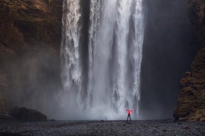
Nicht weit entfernt liegt Skógafoss, ein breiter Wasserfall, der von einer riesigen Sprühnebelwolke umgeben ist. Sie entsteht, wenn das Wasser auf dem felsigen Untergrund aufschlägt. Besucher können den Wasserfall von unten fotografieren oder die Treppe nach oben klettern und von dort ein außergewöhnliches Foto machen.
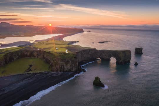
Danach gelangst du bald zur Halbinsel Dyrhólaey. Sie war einst von der Hauptinsel getrennt, bildet jetzt aber ihre Südspitze. Die Halbinsel bietet einen absolut überwältigenden Blick auf die Südküste. Hier kannst du nistende Papageientaucher und den riesigen Felsbogen am Ende der Landzunge fotografieren.
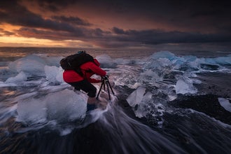
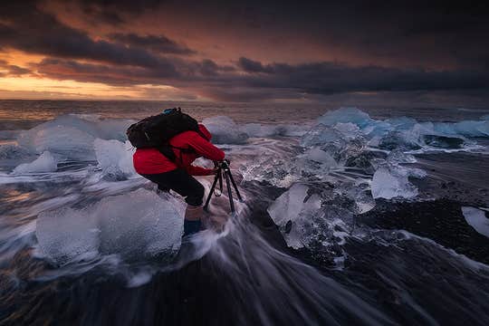
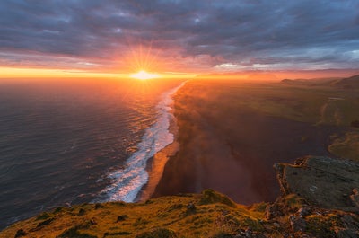
Außerdem besuchst du den schwarzen Sandstrand Reynisfjara, der für seine imposanten Felsformationen und die nahegelegene, hübsche Ortschaft Vík í Mýrdal berühmt ist. Du wirst Gelegenheit haben, beide zu fotografieren, und dein Guide wird auch darauf achten, dass du eine Aufnahme der legendären Felsnadeln Reynisdrangar mit nach Hause nimmst.
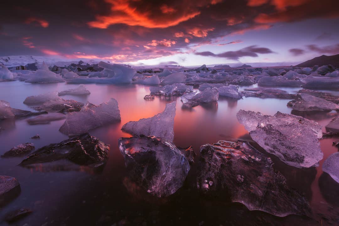
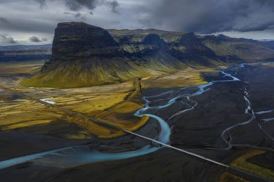
Wenn der Tag sich dem Ende zuneigt, setzt du deine Reise in Richtung des Naturreservats Skaftafell fort. Die Strecke führt dich vorbei an schwarzen Sandwüsten und hohen Bergen. Im Nationalpark angekommen, kannst du noch schnell ein paar Fotos machen und ziehst dich dann in deine Unterkunft zurück.
Tag 2 - Highlights im Vatnajökull-Nationalpark

Dein zweiter Tag beginnt mit einem Fototermin mit der allgemein als ‚Kronjuwel Islands‘ bekannten Gletscherlagune Jökulsárlón. Hier brechen riesige Eisberge von der Gletscherzunge Breidamerkurjökull ab und fallen in das ruhige Wasser der Lagune, wo sie gemächlich auf der Oberfläche treiben. Es ist eine Szenerie, die sich kaum mit Worten beschreiben lässt.
Nur einen kurzen Spaziergang entfernt liegt ein Küstenstreifen mit dem passenden Namen Diamantstrand. An diesem schwarzen Sandstrand werden einige der Eisberge auf ihrem Weg aus der Lagune zum Atlantik angespült und bleiben dort glitzernd und funkelnd liegen.
Wenn du den Diamantstrand fotografiert hast, setzt du dich wieder in den Minibus und dann geht es weiter zu einer anderen Gletscherlagune, Fjallsárlón. Der See Fjallsárlón ist kleiner als Jökulsárlón, aber auch hier gibt es zahlreiche Eisberge zu sehen und zu fotografieren.
Du kannst unvergessliche Bilder von diesem wundervollen Ort unter der Mitternachtssonne machen. Danach ist es Zeit, zurück in deine Unterkunft zu fahren.
Tag 3 - Vatnajökull-Nationalpark & die Südküste

Am Morgen des dritten und letzten Tages deines Foto-Workshops, wählt dein professioneller Guide noch einige andere Highlights des Vatnajökull-Nationalparks aus, denen ihr heute einen Besuch abstattet. Danach macht ihr euch auf den Rückweg nach Reykjavík.
Unterwegs legt ihr noch ein paar Zwischenstopps an der Südküste ein. Da ihr dieselbe Route fahrt wie am ersten Tag, kannst du einige der Naturattraktionen noch einmal unter ganz anderen Lichtbedingungen fotografieren und damit dein mittlerweile gut gefülltes und abwechslungsreiches Portfolio abrunden.