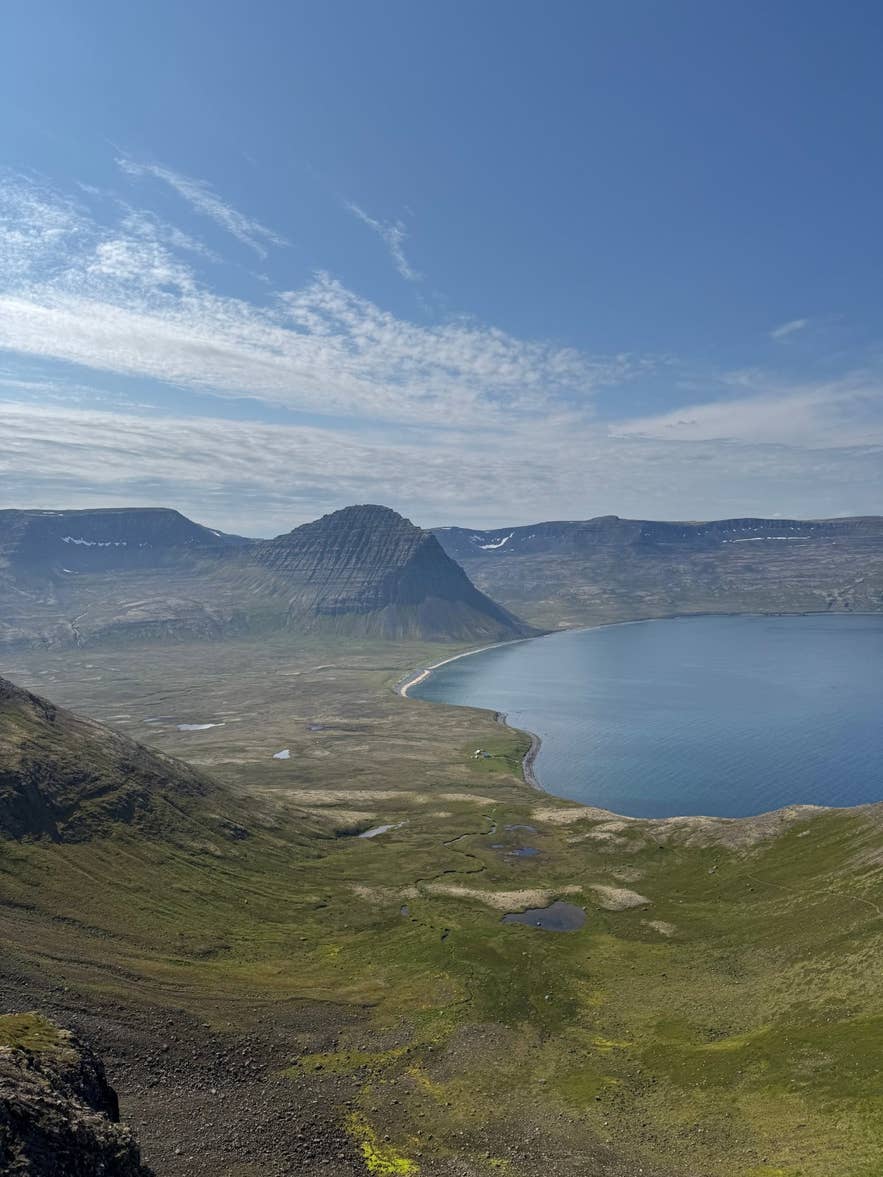
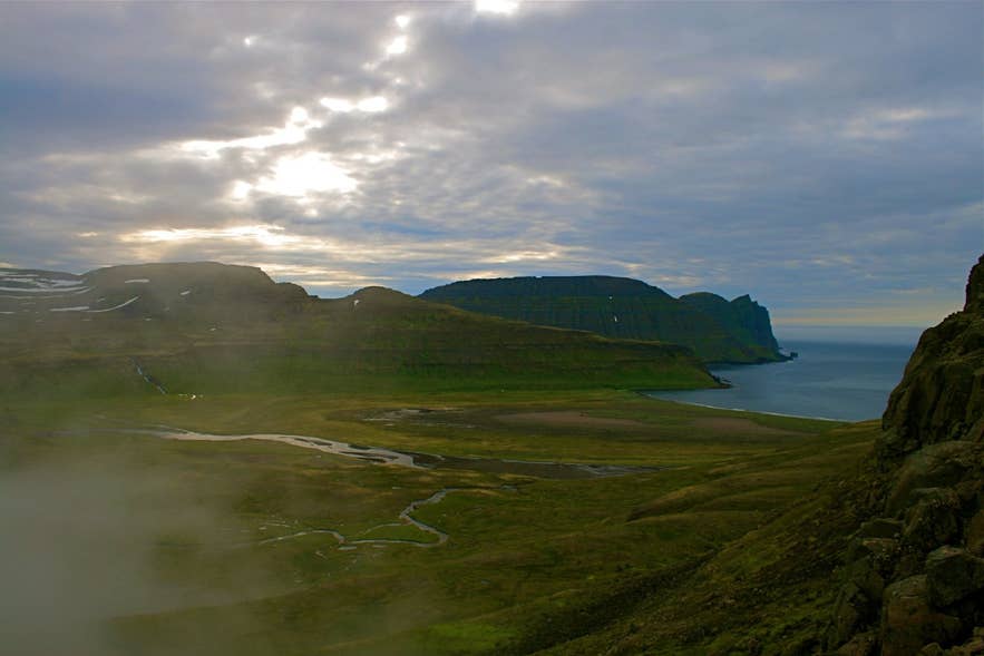
Hlöðuvík from Skálakambur. Photo: Elinarbur, CC BY-SA 4.0
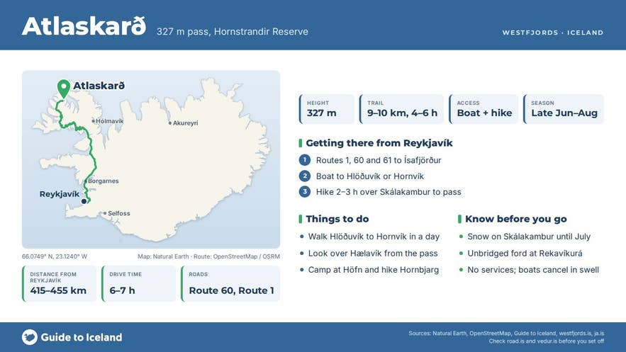
Atlaskarð is a 327-metre mountain pass in the Hornstrandir Nature Reserve in the Westfjords, on the marked trail between Hlöðuvík and Hornvík.
It links the small, uninhabited bay of Hælavík on the west with Rekavík bak Höfn, the cove just west of the Hornvík campsite at Höfn, and it is the lower of the two climbs on that day's walk, the other being the Skálakambur ridge above Hlöðuvík.
Skarð is the Icelandic word for a notch or col in a mountain ridge.
Key Takeaways About Atlaskarð
- 327 m pass between Hælavík and Rekavík bak Höfn on the marked Hlöðuvík–Hornvík trail, Hornstrandir Nature Reserve
- Whole trail about 9–10 km, 4–6 hours, rated level 3 (challenging) by Visit Westfjords; two climbs, Skálakambur (350 m) and Atlaskarð
- Access by summer boat from Ísafjörður or Bolungarvík (Hornvík scheduled, Hlöðuvík on request) or from Norðurfjörður, roughly mid-June to early September
- Best late June to late August; snow on Skálakambur and in the Hælavík valley until the end of June
- No services on the trail; ranger and campsite at Hornvík, campsite at Hlöðuvík; dogs banned
Why visit Atlaskarð
The Hlöðuvík–Hornvík trail is the classic link in the northern Hornstrandir circuit, and Atlaskarð pass is its second high point.
From Hlöðuvík the path passes the old Búðir farm, climbs steeply on a narrow but marked track up the north side of the Skálakambur ridge at about 350 m, drops into the grassy valley behind Hælavík, then climbs again over Atlaskarð at 327 m.
From the pass the view opens east to Hornvík and the bird cliffs of Hornbjarg on the far side of the bay, whose highest point, Kálfatindur, is 534 m; behind you is Hælavíkurbjarg, one of the three great seabird cliffs of Hornstrandir.
The descent runs down to the driftwood-strewn shore of Rekavík bak Höfn, across the Rekavíkurá river and over the Tröllakambur cliff, where hikers report a fixed rope on the smooth rock, to the campsite at Höfn.
The whole route is about 9 to 10 km and takes 4 to 6 hours; Visit Westfjords rates it level 3, challenging. It is the marked way between the two bays on foot, and follows the old route between the farms of Hlöðuvík, Hælavík and Hornvík.
Hælavík itself, abandoned in 1943 and now only ruins, is worth the short detour down to the shore. Arctic foxes den along this coast and are often seen, and in June and July the slopes are full of nesting birds.
How to get to Atlaskarð
Hornstrandir has no roads. Access is by boat from Ísafjörður or Bolungarvík in summer, roughly mid-June to early September (check the current schedules); Ísafjörður is 415 to 455 km and six to seven hours' drive from Reykjavík by Routes 1, 60 and 61, depending on the route taken, or a flight of about 45 minutes.
Scheduled boats land hikers at Höfn in Hornvík on the east; Hlöðuvík on the west is a request stop from Ísafjörður, and Strandferðir sails to both Hlöðuvík and Hornvík from Norðurfjörður in Strandir in high summer. The pass is walked between the two bays.
From the Hlöðuvík campsite the climb over Skálakambur and on to Atlaskarð pass takes roughly 2 to 3 hours; from Höfn in Hornvík allow roughly 2 hours to the pass via Tröllakambur and Rekavík (our estimates from the 4 to 6 hour total).
The route is marked with cairns and signposts and there is a ranger at Hornvík in summer, but no other services anywhere on the trail. Many hikers walk it as day three or four of a circuit Hesteyri – Hlöðuvík – Hornvík – Veiðileysufjörður, which is how most guided groups, including the Guide to Iceland trek below, approach it.
Best time to visit
Late June to late August.
Snow usually lies on Skálakambur and in the Hælavík valley until the end of June and makes the steep descent towards Hlöðuvík dangerous; July is the most reliable month, with near round-the-clock daylight; by late August most seabirds have left the cliffs and the weather turns.
Anyone travelling between 1 March and 15 June, or between 1 September and 1 November, must register a travel plan with the Environment Agency, and boats do not run outside the season.
Safety and practical tips
- The track over Atlaskarð pass itself is clear, but the Skálakambur section is narrow and steep, Tröllakambur has smooth rock above the sea, and the Rekavíkurá is an unbridged ford. Walk the route in good visibility and do not attempt it in high wind.
- Rockfall is possible below the cliffs, and sudden gusts are common on the ridges. Carry windproof and waterproof layers in any weather.
- There are no shops, huts or mobile signal; carry food for the whole trip and a storm-proof tent. Camp only at the designated sites at Hlöðuvík and Höfn, light no fires and take rubbish out.
- Dogs are not allowed in the reserve (only landowners may bring theirs); stay at least 40 m from fox dens and never feed the foxes.
- Register your route at Hornstrandastofa, the visitor centre at Silfurgata 1 in Ísafjörður, and check safetravel.is and the marine forecast; boats are cancelled in rough seas.
How high is Atlaskarð?
How long does the Hlöðuvík to Hornvík hike take?
Is Atlaskarð the same as Atlastaðir?
Can I do it as a day hike?
Nearby attractions
Hornvík bay at the trail's end. Photo: Silverkey, CC BY-SA 3.0
- Skálakambur – the first ridge on the trail from Hlöðuvík, about 3 km
- Hornvík campsite – at Höfn, the eastern end of the day's walk, about 3 km
- Hornvík – the bay, about 4 km to its page pin
- Hælavíkurbjarg – the bird cliff west of Hælavík, about 5 km
- Hornbjarg – the great bird cliff across Hornvík, about 7 km
- Hafnarskarð – the pass south from Hornvík towards Veiðileysufjörður, about 3 km
Tours that visit Atlaskarð
- 6 Day Hiking Tour in Hornstrandir | Camping in the Remote Westfjords – the guided camping trek crosses Skálakambur and Atlaskarð on day four, walking from Hlöðuvík past Hælavík to the Hornvík campsite before the day hike to Hornbjarg.