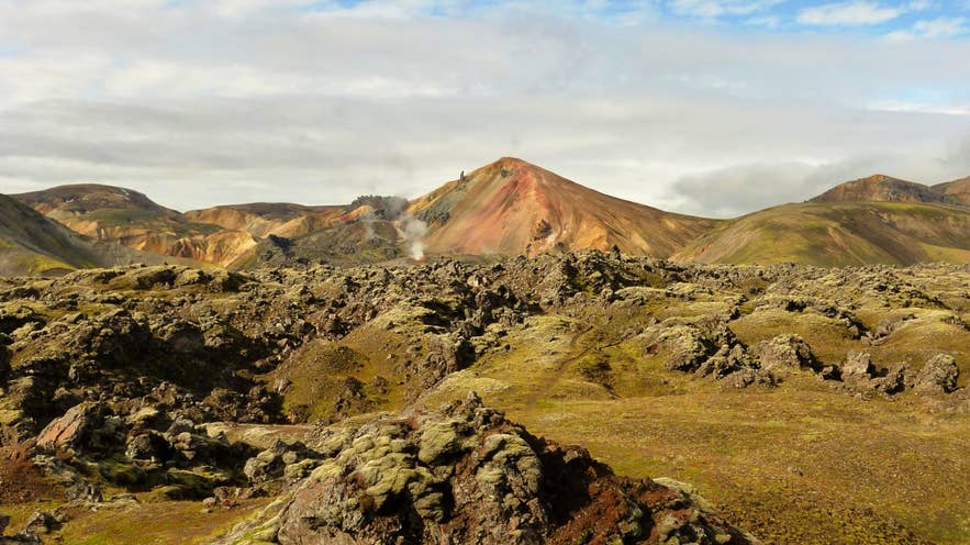
Brennisteinsalda above Laugahraun lava. Photo: Borvan53, CC BY-SA 4.0
Laugahraun (Icelandic: Laugahraun, "the hot-spring lava") is the rough, black lava field that lies directly behind the hut, campsite and natural hot spring at Landmannalaugar in Iceland's southern highlands.
It erupted around 1477 from a fissure that cuts through the rhyolite mountain Brennisteinsalda, and the hot springs that feed the famous bathing brook at Landmannalaugar rise at its edge. It is part of the Fjallabak Nature Reserve and the first landmark on the Laugavegur trail.
Key Takeaways About Laugahraun
- Rhyolite lava field full of obsidian, erupted c. 1477 from a fissure through Brennisteinsalda mountain at Landmannalaugar
- The easiest marked trail at Landmannalaugar: a 4–5 km loop, 1.5–2 hours, little climbing
- First section of the Laugavegur trail; connects to Grænagil ravine and Brennisteinsalda mountain
- Reached only by summer F-roads (F208/F224) with a 4x4, or by highland bus and tours
- The hot springs that feed the famous bathing brook rise at the edge of the lava

Why visit Laugahraun
Most lava fields in Iceland are basalt. Laugahraun is unusual because it belongs to the Torfajökull volcanic system, Iceland's largest area of rhyolite, so its lava is rhyolitic and full of obsidian, natural black volcanic glass.
Walk the path through it and you see shining black blocks, grey pumice-like crust, and thick green moss filling the hollows, all framed by the red, yellow and blue-grey rhyolite slopes of Brennisteinsalda and Bláhnúkur.
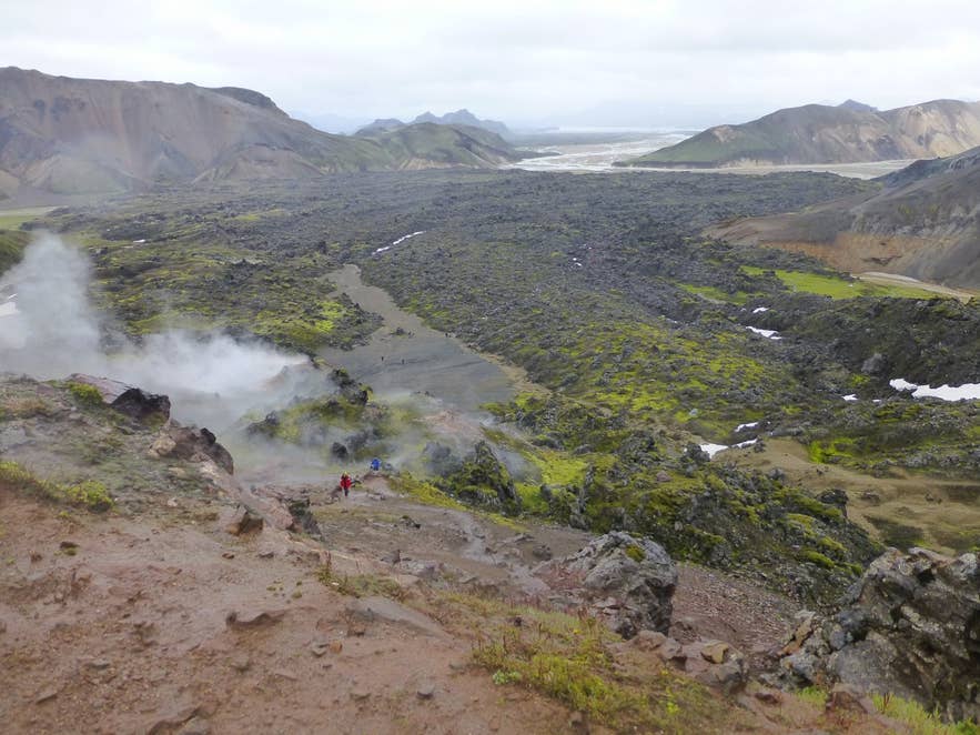
Laugahraun lava field toward Landmannalaugar. Photo: Jürgen Regel, CC BY 3.0
The eruption itself was part of a much larger event.
In 1477 a fissure of the Bárðarbunga–Veiðivötn system opened across the highlands; where it cut through the Torfajökull system it triggered rhyolite eruptions, and Laugahraun, together with the nearby Námshraun lava and the crater lake Ljótipollur, dates from that episode.
The lava is therefore only about 550 years old, young enough that its surface is still sharp and only partly colonised by moss.
Practical reasons to walk it:
- The Laugahraun loop is the easiest marked trail at Landmannalaugar: about 4–5 km and 1.5–2 hours, with little climbing. It is a common choice for families.
- It leads to the base of Brennisteinsalda, where you can see steaming vents and sulphur-stained ground without any climbing.
- It is the first section of the Laugavegur trail, so day visitors and long-distance trekkers share the same path out of the valley.
- It connects to Grænagil, the green rhyolite ravine between the lava and Bláhnúkur, so you can walk out through the lava and back through the ravine without retracing your steps.
How to get to Laugahraun
Laugahraun sits at Landmannalaugar, inside the Fjallabak Nature Reserve in the southern highlands, and you reach it the same way you reach the Landmannalaugar hut and campsite. There is no paved road.
All approaches are summer-only mountain roads (F-roads) that legally require a 4x4, and the roads normally open in June (the Iceland Touring Association advises assuming 20 June) and close again around mid-September, depending on snow.
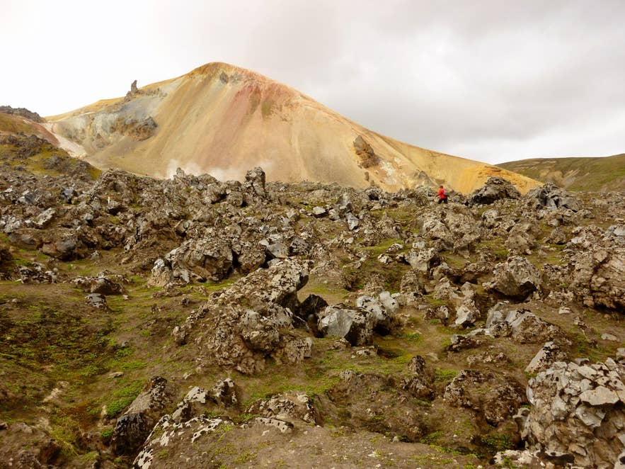
Laugahraun lava below Brennisteinsalda. Photo: Borvan53, CC BY-SA 3.0
- From Reykjavík (about 3.5–4.5 hours, roughly 180–210 km): the most-used route is Route 1 east, then Route 26 (Landvegur) north past Hekla volcano, onto F208 (Fjallabaksleið nyrðri) from the north via the Sigalda power station and Frostastaðavatn lake, and finally the short F224 spur into Landmannalaugar. Driven this way the only unbridged rivers are the two fords on the last stretch of F224, just before the campsite. The Environment Agency recommends that smaller SUVs and inexperienced drivers park in the northern car park (P1) before the fords and walk across the footbridge.
- F225 (Landmannaleið) from Route 26 near Hekla volcano is the western alternative and has several river crossings.
- F208 from the south (from Route 1 west of Kirkjubæjarklaustur, past the Eldgjá fissure) is the roughest option, with several unbridged rivers, and is only for experienced highland drivers in capable 4x4s.
- Without your own 4x4: scheduled highland buses run from Reykjavík, Selfoss and Hella to Landmannalaugar in summer, and most of the GTI tours listed below include transport.
The nearest towns with services are Hella and Hvolsvöllur, each roughly 2 to 3 hours away depending on the route (F225 is the shorter approach). From the Landmannalaugar hut, the Laugahraun lava edge is a few minutes' walk; the lava field itself begins right behind the hot spring.
Parking: Landmannalaugar has used a paid parking and reservation system through the Parka app since 2024.
In 2025, private and rental cars arriving between 9 AM and 4 PM from 20 June to 14 September needed a reservation and paid a service fee per vehicle, and the Iceland Touring Association says the same applies in summer 2026.
Dates, hours and fees change, so check ust.is or parka.is before you drive up.
Best time to visit
Late June to mid-September, when the F-roads are open. July and August give the most reliable conditions and the greenest moss on the lava, but also the fullest car park and campsite.
Early in the season there can be snow patches in the lava and the river at the F224 ford runs high with meltwater. For photography, the low light of early morning or evening brings out the contrast between the black lava and the coloured mountains; midday light flattens it.
Outside summer the area is closed to normal traffic; winter visits are only possible on guided super-jeep tours, and the lava is then usually under snow.
Safety and practical tips
- The lava surface is sharp and uneven. Wear boots with ankle support and stay on the marked path; obsidian edges cut skin and shoes.
- Weather at about 550–600 m elevation changes quickly even in July. Carry a windproof layer, hat and gloves, and check vedur.is and safetravel.is before setting out.
- Near Brennisteinsalda the ground around the steam vents is thin and hot. Stay on the trail and keep children close.
- Facilities (toilets, showers, a small summer shop called the Mountain Mall, the hut and campsite) are at Landmannalaugar itself; there is nothing in the lava field. A service fee applies to campsite and toilet use.
- The natural bathing brook is at the lava edge; use the boardwalk across the boggy banks, and do not use soap in the water.
- Mobile coverage is patchy. Download maps offline.
Nearby attractions
- Landmannalaugar – about 1 km
- Bláhnjúkur – about 0.9 km
- Brennisteinsalda – about 1 km
- Frostastaðavatn – about 4 km
- Ljótipollur – about 6.8 km
- Hrafntinnusker Mountain Peak – about 7.7 km
Tours that visit Laugahraun
Most Landmannalaugar day tours include a walk into Laugahraun, and Laugavegur treks cross it on their first or last day.
- All-Women Laugavegur Trail Hiking Tour for Six Days with Meals and Mountain Huts
- Small Group Landmannalaugar Tour from Reykjavik with a French Guide
- Ultimate 6-Day Laugavegur & Fimmvorduhals Hiking Tour from Reykjavik with Meals and Mountain Huts
- Private Landmannalaugar Super Jeep Tour from Reykjavik with Host Spring Bathing & Hiking
- Ultimate 10-Day Northern Lights Winter Trip to Iceland's Highlands with Ice Caving (winter package whose itinerary includes Landmannalaugar; the lava field is usually under snow at that time)
- Super Jeep & Hiking Tour of Landmannalaugar & Waterfalls with Transfer from Reykjavik
- Landmannalaugar Super Jeep Tour From Reykjavik
- Landmannalaugar Geothermal Area | Super Jeep Day Tour
- Scenic 5-Day Road Trip Adventure Through Iceland's South Coast, Landmannalaugar & Highlands (package: the itinerary includes a stop at Landmannalaugar, where this is one of the walks on offer)
- Adventurous 1-Week Summer Self-Drive Tour of Iceland with Highlands Exploration (package: the itinerary includes a stop at Landmannalaugar, where this is one of the walks on offer)
- Landmannalaugar Hiking & Hot Spring Tour from Reykjavik
- 8-Day Laugavegur Trail Tour with Glacier Hike, Golden Circle, and South Coast from Reykjavik
- Guided 7-Day Laugavegur Trail Tour with Solheimajokull Glacier Hike from Reykjavik
- Exciting 5-Day Laugavegur Trekking with South Coast Tour and Glacier Hiking from Reykjavik
- Action-Packed 5-Hour Hiking and Hot Springs Tour of Landmannalaugar
- Guided 4-Day Highland Hiking Tour of the Laugavegur Trail from Reykjavik
- Private Landmannalaugar Tour from Hvolsvollur
- Landmannalaugar Hike and the Valley of Tears From Reykjavik & Selfoss
- Thrilling 11-Hour Private Landmannalaugar Super Jeep Day Tour from Reykjavik
- Private 11-Hour Super Jeep and Hiking Tour of Landmannalaugar from Reykjavik
- Small-Group 7-Day Highlands Hiking Tour of the Eldgja and Strutur Trails with Reykjavik Transfers
- Adventure-Packed 4-Day Eldgja Trek Expedition through Iceland's Highlands from Reykjavik
- Private & Intimate 8-Hour Super Jeep Adventure Tour Exploring Eldgja Canyon & Landmannalaugar
- Small-Group 3-Day All-Inclusive Hiking Tour of Landmannalaugar from Reykjavik
- 4-Day Laugavegur Hiking & Camping Tour from Reykjavik
- 3-Day Summer Sightseeing Tour of the Westman Islands, South Iceland, & Highlands from Reykjavik
- Thrilling 4-Day Hiking Tour in Fjallabak Nature Reserve from Reykjavik
