
Mýrdalsjökull across Mýrdalssandur. Photo: Hansueli Krapf, CC BY-SA 3.0
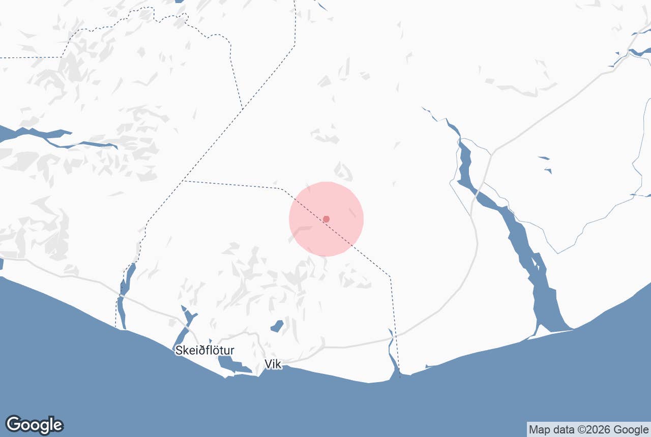
Kötlujökull is the large outlet glacier that flows east and south-east out of the Mýrdalsjökull ice cap in South Iceland, ending on the black sands of Mýrdalssandur north-east of Vík í Mýrdal.
Its name means "Katla's glacier": it drains the ice-filled caldera of the Katla volcano, and it is the glacier where the Katla Ice Cave tours take place. Most visitors meet their guides in Vík and travel the final stretch by super jeep, because no public road reaches the ice.
Key Takeaways About Kötlujökull
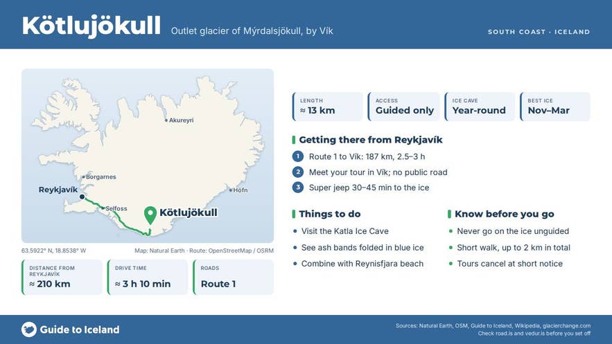
- Eastern outlet glacier of Mýrdalsjökull, draining the ice-filled Katla caldera; about 13 km long
- Ice banded with ash from past Katla eruptions, which is what gives the Katla Ice Cave its black-and-blue walls
- No public road: tours leave Vík by modified super jeep, about 30 to 45 minutes to the glacier edge
- Guided ice-cave visits run year-round; never go onto the glacier without a certified guide
- Has retreated 1–1.5 km in the last 30 years; floods from under it built Mýrdalssandur
Why visit Kötlujökull
Mýrdalsjökull is Iceland's fourth-largest ice cap, covering about 520 square kilometres in the 2019 survey (down from roughly 595 in 1980), with an average ice thickness of about 230 metres and up to around 700 metres inside the Katla caldera.
The caldera rim is lowest on the eastern side, so most of the ice flows out that way as Kötlujökull. The glacier runs about 13 kilometres from the caldera, squeezes through a valley about 3 kilometres wide and then fans out into a broad lobe that ends at only around 200 metres above sea level.
What makes the ice here distinctive is its colour. Katla has erupted roughly every 40 to 80 years since settlement (the last large eruption was in 1918), and each eruption buried the glacier in ash.
Those ash layers are now folded into the ice, so the caves and ice walls on Kötlujökull show dark bands of volcanic ash running through blue glacier ice, rather than the clean blue of Vatnajökull's caves.
Because the ice is debris-covered and relatively low-lying, guided ice-cave visits here run year-round, which few Icelandic ice caves allow.
The glacier also shows climate change clearly. Kötlujökull has retreated by 1 to 1.5 kilometres over the last 30 years, with the southern margin holding on longer because its cover of ash and gravel insulates the ice.
Researchers dating the outermost moraines with ash layers found the glacier was at its largest around the start of the fifth century AD, two kilometres beyond its 19th-century position, which is unusual for an Icelandic glacier.
The jökulhlaups (glacial outburst floods) that follow Katla eruptions pour out from under Kötlujökull across Mýrdalssandur. Historic floods have reached discharges of several hundred thousand cubic metres per second, and the 1918 flood pushed the coastline out by about 5 kilometres. The wide sand plain you cross on the Ring Road east of Vík is the product of those floods.
How to get to Kötlujökull
Kötlujökull lies about 20 kilometres north-east of Vík as the crow flies. Vík is roughly 187 kilometres from Reykjavík on Route 1 (the Ring Road), about 2.5 to 3 hours in good conditions.
From Vík, Route 1 continues east across Mýrdalssandur, and rough tracks lead north from the Höfðabrekka area toward the glacier snout.
These tracks cross glacial outwash and are not suitable for normal cars or standard rental 4x4s; tour operators use modified super jeeps and quote about 30 to 45 minutes from Vík to the glacier edge.
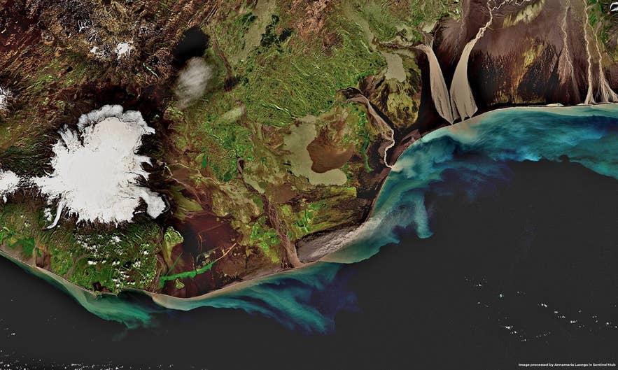
Kötlujökull from space. Photo: Annamaria Luongo / Copernicus Sentinel data, CC BY 2.0
There is no public car park at the ice. Tours departing from Vík meet at a point in the village named on each tour page, which varies by operator.
From where the jeeps stop, expect a short walk over uneven, icy ground to reach the cave; operators describe up to about 2 kilometres of walking in total, and one tour includes a short, steep section with rope assistance.
Best time to visit
Katla Ice Cave tours on Kötlujökull run all year. In winter (November to March) the ice is coldest and most stable and the colours are at their deepest, but daylight is short and the roads to Vík can be icy.
In summer the cave is still accessible but changes shape quickly as meltwater carves it, so the route and entrance are re-checked before every visit. Expect a different cave in July than in January.
Safety and practical tips
- Never approach or enter the glacier without a certified guide. Crevasses, moulins, collapsing ice and sudden meltwater surges are real hazards, and the cave is reassessed daily.
- Helmets and crampons are supplied by the operators. Bring waterproof outer layers, warm layers, a hat, gloves and hiking boots with ankle support. There is nowhere to rent clothing at the glacier.
- Tours set a minimum age; check the specific tour page before booking.
- Weather, high water levels or glacier movement can cancel tours at short notice. Build a buffer day into your South Coast plans if the cave is a priority.
- Kötlujökull sits on an active volcano. Katla is monitored closely by the Icelandic Met Office; follow guide instructions and any Civil Protection notices.
- There are no facilities at the glacier. Toilets, fuel and food are in Vík.
Is Kötlujökull the same as the Katla Ice Cave?
Can I drive to Kötlujökull myself?
Why is the ice black and blue?
Is it safe to visit a glacier on an active volcano?
How long is the walk on the glacier?
Nearby attractions
- Thakgil Canyon – about 6 km. A green, sheltered canyon and campsite north of Höfðabrekka.
- Hafursey – about 9 km. A 582 m tuff mountain rising from the western edge of Mýrdalssandur, south-east of the glacier snout.
- Katla Volcano – about 11 km. The volcano beneath the ice that feeds this glacier.
- Myrdalsjokull Glacier – about 17 km. The ice cap that Kötlujökull drains.
- Myrdalssandur – about 18 km. The outwash plain built by Katla's floods.
- Vik – about 21 km. The village where the tours start.
- Reynisfjara Black Sand Beach – about 23 km. The famous basalt-column beach west of Vík, easily combined with an ice cave tour.
