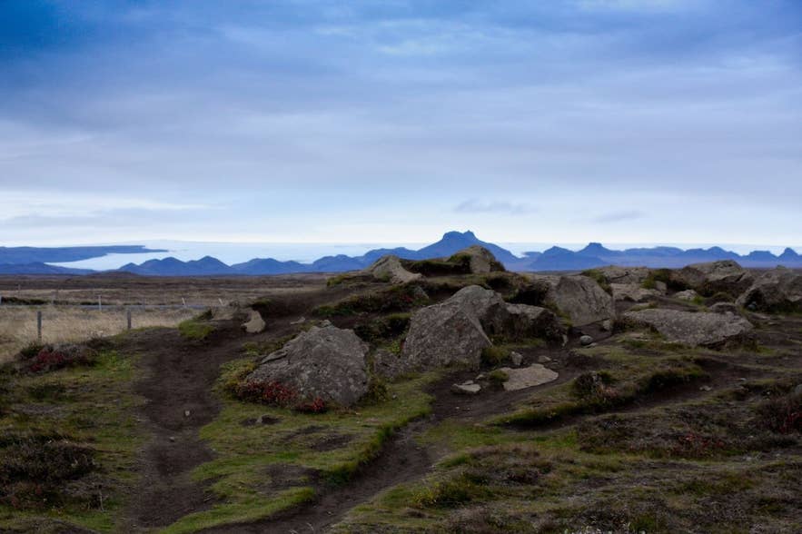
Langjökull's edge above Hagavatn basin. Photo: dolbex, CC BY 2.0
Vestari-Hagafellsjökull is the western of two glacier tongues that spill off the southern edge of Langjökull, Iceland's second-largest ice cap, into the highland basin north-east of Gullfoss.
Its name means "western Hagafell glacier": the twin outlets are split by Hagafell, a mountain that pushes north into the ice, with Vestari-Hagafellsjökull (western) on one side and Eystri-Hagafellsjökull (eastern) on the other. The eastern tongue ends at the glacial lake Hagavatn; the western tongue ends on the gravel flats west of Hagafell.
Together they are among the best-documented surging glaciers in Iceland.
Key Takeaways About Vestari-Hagafellsjökull
- Western of the two Hagafellsjökull tongues on the south side of Langjökull, split from Eystri-Hagafellsjökull by Hagafell mountain
- A surging glacier: surges recorded in 1971 and 1980, and an aborted surge in 1997–98
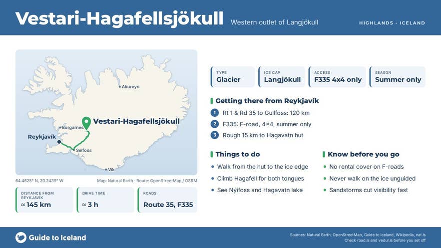
- Reached via Road 35 past Gullfoss and the 4x4-only F335 Hagavatnsvegur; about 145 km from Reykjavík to the Hagavatn hut, a full day
- Hagavatn lake below the eastern tongue burst its banks in 1929 and 1939, creating Nýifoss
- Summer only, roughly late June to September; no services beyond Gullfoss; FÍ Hagavatn hut sleeps 12
Why visit Vestari-Hagafellsjökull
Langjökull covers about 870 square kilometres, stretches about 50 kilometres from north to south and 15 to 20 kilometres across, and is up to 580 metres thick; its highest point rises to about 1,450 metres.
The Hagafellsjökull tongues are the ice cap's southernmost arm, and from the gravel plains around Hagavatn and Sandvatn you see them as a broad white wall above the dark ridges of Jarlhettur, a chain of volcanic peaks that formed under the ice and now stands along the glacier's eastern flank.
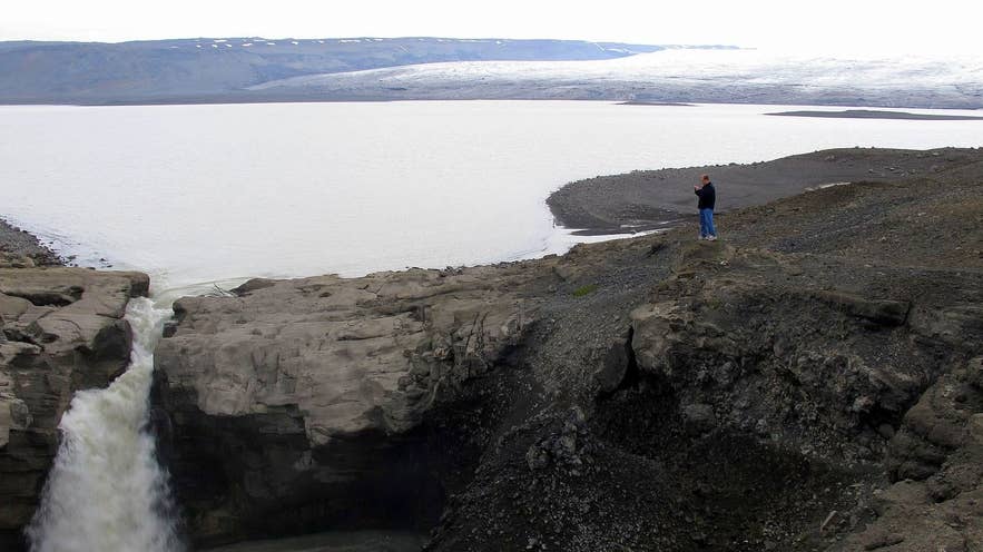
Hagavatn below the Hagafellsjökull tongues. Photo: M S, CC BY-SA 2.0
What makes these glaciers unusual is how they move. Instead of flowing steadily, both Hagafellsjökull tongues surge: they sit almost still for years, then lurch forward. Glaciologists recorded Vestari-Hagafellsjökull surging in 1971, Eystri-Hagafellsjökull in 1975, and both together in 1980.
Between summer 1997 and autumn 1998 the surface of the western tongue sped up from about 50 to 250 metres a year in a zone 4 to 12 kilometres above its snout, then abruptly slowed again.
The glaciologists who recorded it called it an aborted surge and speculated that a sudden flood, which cut deep new watercourses in front of the glacier in autumn 1998, may have ended it. The eastern tongue carried on, surging into Hagavatn in 1998–99, displacing lake water and destroying the footbridge over the outlet river Farið.
A new footbridge was built below Einifell in 2006.
Hagavatn itself has a dramatic history.
The lake is dammed by old lava and the Jarlhettur ridge, and more than once it has burst its banks: outburst floods in 1929 and 1939 cut new outlets and lowered the lake sharply, carving the gorge and the waterfalls Nýifoss ("new falls") and Leynifoss on the Farið river, which drains to Sandvatn and on to the Hvítá and Tungufljót rivers.
Icebergs used to calve into the lake; they no longer do. Around the shore the land is bare and windblown, with only about 14 percent vegetation cover, and sandstorms off the glacial silt are common.
How to get to Vestari-Hagafellsjökull
The approach is from the Golden Circle. From Reykjavík take Route 1 and Road 35 to Gullfoss (about 120 kilometres, roughly 2 hours). Continue north on Road 35 (Kjalvegur), which becomes the gravel Kjölur highland road beyond the waterfall.
About 10 kilometres beyond Gullfoss, turn left onto Hagavatnsvegur (F335), a rough 15-kilometre track that leads north-west to the Hagavatn hut and the lake. This is a 4x4-only track with soft sand and steep, loose sections near the end; many drivers park before the final climb and walk the last stretch to the lake.
From the hut, walking routes lead over the ridge to the glacier margins and up onto Hagafell for views of both tongues; reaching the western tongue means crossing the Hagafell ridge or rounding its southern end, so allow a full day from Reykjavík.
The Hagavatn hut, built in 1942 and renewed in 1986, is run by the Icelandic Touring Association (Ferðafélag Íslands). It sleeps 12, stands about 2 km from the lake, and should be booked in advance.
Best time to visit
The Kjölur road (35) from Gullfoss normally opens around the start of June (Vegagerðin's average opening date is 1 June); Hagavatnsvegur (F335) is a lower-standard track that opens later, usually by late June or July, and both close with the first snows in September or October. Check road.is before setting out.
July and August are the most reliable months for access and for the walk to the ice. Early autumn brings clearer air and fewer sandstorms. In winter the area is reached only on guided snowmobile or super jeep trips, if at all, and the glacier edge is dangerous without a guide.
Safety and practical tips
- Never walk onto the glacier without a guide, crampons and rope. Surging glaciers are heavily crevassed, and the margins of Vestari-Hagafellsjökull are fractured and unstable.
- Hagavatnsvegur is unsuitable for small 4x4s and all two-wheel-drive cars; rental insurance does not cover damage on F-roads or from sand.
- The glacial rivers here change course. Do not ford Farið or any other river without checking depth and flow.
- Wind-blown silt can cut visibility to a few metres in minutes. Carry a map and GPS; there is no mobile coverage in parts of the basin.
- There are no services beyond the Gullfoss café and visitor centre. Bring fuel, food and water.
What is a surging glacier?
Can I walk on Vestari-Hagafellsjökull?
Do I need a 4x4 to get there?
Is Hagavatn safe to swim in?
When is the road open?
Nearby attractions
- Hagavatn, 5 km, the glacial lake below the eastern Hagafellsjökull tongue
- Nýifoss, 7 km, the waterfall created when the lake burst its banks
- Einifell, 8 km, the hill beside the Hagavatn hut
- Hlöðufell, 12 km, a table mountain formed under Ice Age glaciers
- Sandvatn, 13 km, the shallow lake that Hagavatn drains into
- Jarlhettur, 14 km, the ridge of subglacial volcanic peaks along Langjökull's edge
- Gullfoss Waterfall, about 23 km
Tours that visit Vestari-Hagafellsjökull
- Golden Circle Buggy Tour from Reykjavik: a 10-hour self-drive buggy day that crosses Mosfellsheiði to Þingvellir, then runs highland tracks past Hagavatn and Sandvatn with both Vestari- and Eystri-Hagafellsjökull in sight before reaching Gullfoss and Geysir. Operates May to November.