Understand Iceland's road system before you drive, and the whole country opens up to you. This guide covers the road types, route numbers, F-roads, tolls, and how to check live conditions, so you can choose the right car and plan realistic days. Read on to drive with confidence.
Iceland's roads change quickly in character, and the road type often decides what rental car you need and where you can go. Most visitors loop the paved Ring Road, while the rough F-roads open the Highland interior only to 4x4 vehicles, and only in summer.
Why You Can Trust Our Content
Guide to Iceland is the most trusted travel platform in Iceland, helping millions of visitors each year. All our content is written and reviewed by local experts who are deeply familiar with Iceland. You can count on us for accurate, up-to-date, and trustworthy travel advice.
Because conditions shift with the season and the weather, understanding the system helps you choose the right vehicle, avoid closed roads, and plan sensible driving days. It also makes booking simpler, since one of our self-drive tours can map the whole route for you.
This guide is built for first-time drivers, Ring Road travelers, and Highland visitors alike. For the complete rulebook, see our guide to driving in Iceland, and for route ideas, browse the top road trips in Iceland. It breaks down road types, numbering, the rules visitors miss, tolls, hazards, and how to read the country's official road alerts.
Iceland's roads range widely, with paved Route 1, gravel regional roads, and seasonal Highland tracks often on one trip. Understanding the system helps you pick the right car, avoid closures, and plan realistic days.
What to Know About Iceland's Road System
-
The Ring Road (Route 1) circles the country for about 810 miles (1,300 kilometers) and is paved the whole way.
-
Iceland drives on the right. Headlights must be on day and night, and seat belts are required for everyone.
-
A 2WD car handles the Ring Road and most paved routes in summer, while F-roads legally require a 4x4.
-
Roads are numbered by region, with one and two-digit routes for main roads and three digits for smaller ones.
-
Speed limits are 56 mph (90 km/h) on paved roads, 50 mph (80 km/h) on gravel, and 31 mph (50 km/h) in towns.
-
Only one tunnel, Vadlaheidi in the north, charges a toll, and you pay it online.
-
Check the official live map at umferdin.is (also reached at road.is) before every drive, and treat any road marked impassable (Ofaert) as closed.
-
The emergency number is 112, and you can call 1777 for road information.
Iceland's Road Types Explained
Here is how Iceland's main road types compare, so you can match your route to the right vehicle and season.
| Road type | What it is | Surface | Vehicle needed | When open |
|---|---|---|---|---|
| Ring Road (Route 1) | Main highway circling Iceland | Paved | Any car | Year-round |
| Main roads (1-2 digit) | Primary regional routes | Mostly paved | 2WD | Year-round |
| Secondary roads (3 digit) | Smaller local routes | Often gravel | 2WD, with care | Mostly year-round |
| F-roads | Highland mountain tracks with river fords | Rough gravel | 4x4 (required by law) | Summer only |
| Unnumbered tracks | Rough dirt tracks for locals | Unpaved | 4x4 only | Seasonal |
Iceland's Official Road Classes
Traveler shorthand like Ring Road, secondary roads, and F-roads is useful, but Iceland's official system is broader. The Icelandic Road and Coastal Administration sorts the public network into classes such as main roads, connecting roads, regional roads, and Highland roads, plus municipal and private roads.
In practical terms, the takeaway is simple. The farther you move from the main roads, the more likely you are to meet gravel, lighter maintenance, and seasonal mountain-road limits.
These categories blur together on a real trip, so it helps to know what each looks like on the map.
What Each Road Type Looks Like
Paved main roads cover Route 1 and busy regional routes like Route 54 around the Snaefellsnes Peninsula and the roads through the Golden Circle area. They suit any car in summer.
Gravel takes over on many secondary and mountain routes, such as parts of Route 35 (Kjolur) and the long Route 60 through the Westfjords. These call for slower speeds and, on the toughest sections, a 4x4.
The F-roads sit at the far end, including F35, F208, F249, F26, and F88. They are summer-only Highland tracks that the law reserves for 4x4 vehicles.
What Car You Need for Each Iceland Route
The right car depends on your route and the season. A 2WD is fine for the Ring Road and most paved roads in summer, while the Highlands and many winter drives call for a 4x4.
| Route or season | 2WD okay? | 4x4 needed? | Notes |
|---|---|---|---|
| Reykjavik and Golden Circle, summer | Yes | Optional | Main roads are paved |
| Ring Road, summer | Yes | Optional | Watch weather and short gravel detours |
| Snaefellsnes Peninsula, summer | Yes | Optional | Some gravel side roads |
| Westfjords | Sometimes | Recommended | Long gravel and steep passes |
| Highlands and F-roads | No | Required | Summer only, by law |
| Countryside in winter | Sometimes | Recommended | Depends on route and forecast |
When a 2WD Is Enough, and When to Size Up
For summer Ring Road trips, a small 2WD keeps costs down and reaches the main sights. If you plan gravel side roads, the Westfjords, or any winter driving, a 4x4 adds grip and clearance.
Legal Rules Versus Rental-Company Rules
Highland F-roads are a separate case. The law requires a 4x4, and not every 4x4 is approved for every route, so check your agreement before you rent a 4x4 for river crossings. Safe Travel warns that not all four-wheel-drive cars suit every F-road, and some routes need a larger vehicle or a guided super jeep.
Most rental insurance does not cover water damage, so fording rivers is at your own risk even in a capable vehicle.
What the Ring Road (Route 1) Covers
The backbone of the network is the Ring Road, also called Route 1, which loops the whole island for about 810 miles (1,300 kilometers). It is paved along its full length and is mostly one lane in each direction.
Most of Iceland's towns and best-known sights sit on or near it. Branch off and you reach areas like the South Coast and the wider regions beyond.
The Ring Road does not reach everywhere, though. It skips the Westfjords entirely, misses most of the Snaefellsnes Peninsula, and never enters the Highlands, so those areas need extra time and often a different vehicle.
How Road Numbers Work in Iceland
The numbering system is logical once you know the pattern. Route 1 is the Ring Road, and the first digit of every other route tells you which region the road sits in.
One and two-digit numbers belong to main roads, such as Route 54 on Snaefellsnes or Route 93 to Seydisfjordur. Three-digit numbers mark smaller routes, like Route 939 over the Oxi Pass.
An F before a number, such as F208, signals a Highland mountain road with its own strict rules. A few tracks are unnumbered dirt roads best left to locals and well-equipped 4x4s.
The first digit often helps you place a road by region, but route quality still depends on terrain, maintenance, and season. These examples show the range.
| Route | Region or use | What travelers should infer |
|---|---|---|
| Route 1 | Ring Road | Main paved loop around inhabited Iceland |
| Route 54 | Snaefellsnes | Easy regional road for self-drive |
| Route 60 | Westfjords | Regional road, remote and often gravel in parts |
| Route 93 | To Seydisfjordur | Scenic mountain pass, weather-sensitive |
| Route 939 | Oxi Pass | Smaller mountain route, rougher and slower |
| F26, F88, F249 | Highland routes | Seasonal 4x4 roads with route-specific risk |
Paved Roads vs Gravel Roads in Iceland
The Ring Road and busy regional roads are paved and easy to drive on during summer. Many routes off them turn to gravel, especially in rural areas and the Westfjords.
Gravel reduces grip and throws up stones, so slow down and leave more space. Take extra care where pavement suddenly changes to gravel, a common spot for skids, and ease off before blind rises and loose shoulders.
Stone chips are common on gravel, so keep your distance from other cars. When you stop for photos, pull fully off the road, as stopping in the lane is dangerous and illegal.
Road Rules Visitors Often Miss
Iceland drives on the right, and the core rules are strict. Headlights must be on day and night, seat belts are required for everyone, and using a handheld phone while driving is banned.
Off-road driving is illegal everywhere and carries heavy fines, as it scars fragile terrain. The drink-driving limit is low, set at 0.02 percent blood alcohol (0.2 per mille), so do not drink and drive.
Speed limits are 56 mph (90 km/h) on paved roads, 50 mph (80 km/h) on gravel, and 31 mph (50 km/h) in towns, and fixed cameras enforce them. Posted signs always override the default limits.
Roundabouts catch many visitors out. In a two-lane roundabout, the inner lane has priority when exiting, so cars in the outer lane must yield, and you should signal as you leave.
One-lane tunnels work on right-of-way signs and pull-off bays, not on size or who is going uphill. Watch for the sign that tells you to yield, and use the next bay to let oncoming traffic pass.
F-Roads and Highland Mountain Roads
What F-Roads Are
The F-roads lead into the Highlands, and the F comes from fjallvegur, the Icelandic word for mountain road. They are rough, unpaved, and sometimes cross rivers with no bridge.
By law, F-roads require a 4x4, and a two-wheel-drive car is not allowed on them. Popular routes include F35 (Kjolur), F208 to Landmannalaugar, F249 to Thorsmork, and remoter tracks like F26 (Sprengisandur) and F88 to Askja.
When Are the F-Roads Open
They are seasonal, often opening around late June, depending on snowmelt and yearly conditions, with the remote interior opening later. Many F-roads have no fuel, food, or phone signal, so carry supplies and tell someone your plan.
River Crossings and Insurance
River crossings are the biggest risk. Most rental insurance excludes water damage, so never enter a ford you cannot read, and turn back if the water looks too deep or fast.
Which F-Roads Are Harder
F-roads are not one experience. A few routes commonly called F-roads have been upgraded or reclassified over time, so always check the current map, and match the route to your vehicle and experience.
| Route | Why people drive it | River crossings | Typical difficulty | Minimum practical vehicle |
|---|---|---|---|---|
| F208 / F225 to Landmannalaugar | Popular Highlands introduction | Light to moderate | Moderate | Highland-capable 4x4 |
| F26 Sprengisandur | Long central crossing | At least one real crossing | Difficult | Medium to large 4x4 |
| F88 to Askja | Access to Askja | Risky final crossing in high water | Difficult | Large 4x4 |
| F249 to Thorsmork | Famous but notoriously risky | Multiple, ending at the Krossa River | Very difficult | Often best as a guided Super Jeep trip |
Some F-roads are realistic for prepared 4x4 renters in good weather, while others are best left to experienced drivers or guided Super Jeep tours.
Single-Lane Bridges, Tunnels, and Blind Rises
Rural Iceland still has around 30 single-lane bridges, with most of the Ring Road ones in the south and the Eastfjords. The number keeps falling as bridges are upgraded, but the rule stays the same. Safe Travel advises slowing down early and letting the vehicle closer to the bridge go first, while always yielding to a vehicle already on it.
Blind rises, marked Blindhaed, hide oncoming traffic as the road crests a hill, so ease off and keep right. A few single-lane tunnels have signed pull-off bays, and the driver nearer a bay is expected to use it.
Toll Roads and Tunnels in Iceland
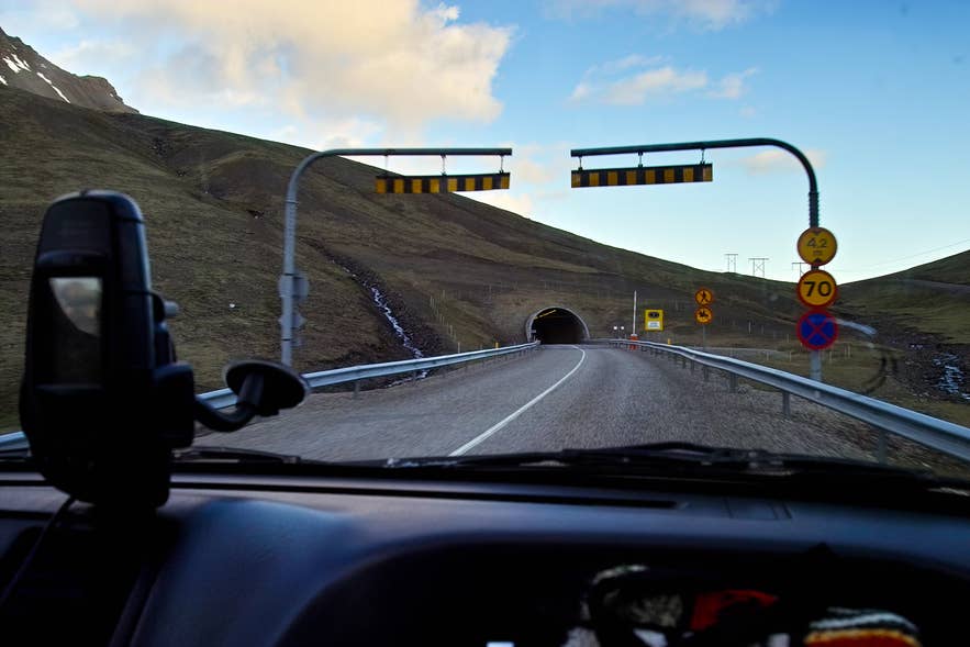
For a car under 3.5 tons, the official single-trip price is 2,216 ISK, set in early 2026, and prices can change. Cameras read your license plate, and you pay online at the official tunnel website up to 24 hours before or after you drive through. Unpaid trips are billed to the vehicle owner before any collection fee applies.
How to Check Iceland Road Conditions
How to Use the Official Map
Iceland's official live traffic map is umferdin.is, run by the Icelandic Road and Coastal Administration and also reached at road.is. It color-codes every route by condition and marks closed roads as impassable, shown by the word Ofaert.
What the Road-Status Terms Mean
Read the colors as a warning scale. Common labels include slippery (Halka), difficult driving (Thungfaert), spots of ice, snow, and closed (Lokad), and webcams and wind readings sit alongside the map.
| Status | Meaning | What to do |
|---|---|---|
| Greidfaert | Easily passable | Drive normally and stay alert |
| Halka | Slippery or icy | Slow down and leave more space |
| Thungfaert | Difficult driving | Delay if you can, go only if confident |
| Snjor | Snow on the road | Reduce speed, a 4x4 helps |
| Lokad | Closed | Do not enter |
| Ofaert | Impassable | Do not drive, take another route |
Build a Check Routine Before You Drive
Build a simple routine before each drive. Check the live map for your route, check the forecast and wind at vedur.is, and read current alerts at safetravel.is.
Watch wind speed, not just snow or rain, and recheck before long remote stretches. Never continue onto a road marked impassable or closed, and call 1777 for road information or 112 in an emergency.
If something goes wrong, match the call to the problem. Call 112 if anyone is in danger, and call your rental company's roadside number first for a purely mechanical issue like a flat tire or a dead battery.
Icelandic Road Signs to Know
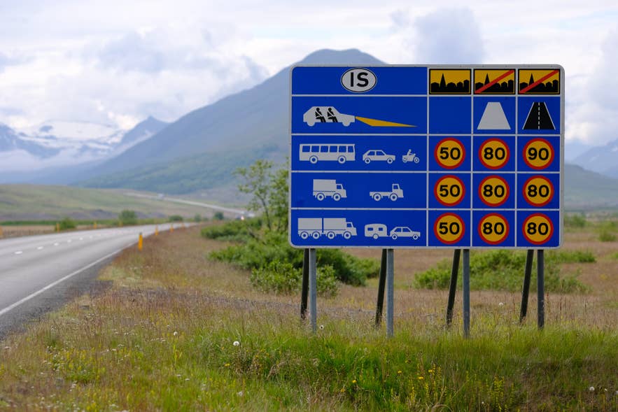 A few Icelandic words appear again and again on road signs. Here is what they mean.
| Sign | Meaning | What to do |
|---|---|---|
| Einbreid bru | Single-lane bridge | Slow down, let the nearer car cross first |
| Blindhaed | Blind rise | Ease off and keep right |
| Malbik endar | Pavement ends | Slow before the gravel starts |
| Vegavinna | Road work | Reduce speed and watch for crews |
Common Road Hazards in Iceland
 Sheep roam freely in summer and often graze near or wander onto rural roads, so be ready to slow for them. Hitting livestock is dangerous and costly, as you may be liable for the animal.
Wind is the hazard visitors underestimate most. Strong gusts can tear a car door off or push a campervan off the road, so park nose into the wind and hold doors firmly on exposed stretches.
Other common hazards include loose gravel, blind rises, sudden fog, blowing sand near the South Coast, river crossings in the Highlands, and roads that close at short notice in bad weather.
Driving Iceland's Roads by Season
Summer
Summer is the easiest time to drive. Days are long, the full Ring Road is open, gravel detours are manageable, and the Highlands gradually open for 4x4 travel.
Shoulder Season
Shoulder season in spring and fall brings changing conditions. Some Highland roads stay closed, and snow or ice can return, so safetravel.is notes that winter-style conditions are possible outside winter too.
Winter
Winter means short daylight, possible closures, strong winds, and icy roads, with limited access to remote areas. Plan shorter days, keep your fuel topped up, and confirm your rental has proper winter tires.
Highland Season
Highland season is the shortest. F-roads usually open in stages around late June and close again in autumn, with exact dates set by snow and road conditions each year. Treat any opening date as provisional, since it depends on spring weather and snowpack, and check the road administration's Highlands map before you go.
What Not to Do on Iceland's Roads
A short list of mistakes causes most visitor accidents and fines.
-
Do not drive off-road, even for a photo, as it is illegal and damages the land.
-
Do not stop in the driving lane. Pull fully into a parking area or off the road.
-
Do not enter roads marked impassable or closed.
-
Do not take a 2WD onto F-roads.
-
Do not cross rivers unless your vehicle is suitable and you can judge the depth and current.
-
Do not underestimate wind warnings, especially in a campervan or small car.
-
Do not rely only on Google Maps in the Highlands, where routing can be wrong or unsafe.
How Long It Takes to Drive Around Iceland
Driven non-stop, the Ring Road is roughly 16 to 17 hours behind the wheel. In practice, you want far more time to stop, detour, and drive within daylight.
| Trip length | What it suits |
|---|---|
| 5 days | Rushed, not ideal for the full loop |
| 7 days | Possible in summer with limited detours |
| 10 days | A comfortable Ring Road pace |
| 14 days | Adds the Westfjords, Snaefellsnes, and Highlands |
| Winter | Add buffer days and shorter routes |
Winter trips need extra buffer days for weather, and the Westfjords and Highlands always slow the pace, so build in a margin rather than packing the schedule.
It also helps to know real distances and driving times between key points. These are approximate and assume good summer conditions.
| Route | Distance | Typical driving time |
|---|---|---|
| Reykjavik to Vik | 116 miles (187 km) | About 2.5 hours |
| Reykjavik to Akureyri | 242 miles (389 km) | About 5 hours |
| Egilsstadir to Seydisfjordur | 17 miles (27 km) | About 30 minutes |
| Full Ring Road loop | 810 miles (1,300 km) | 16 to 17 hours of driving |
Best Road Trips by Road Type
Different road types suit different trips. For paved, beginner-friendly driving, the Golden Circle and the wider Ring Road are the classic starting points.
For a mix of paved and light gravel, the Snaefellsnes Peninsula and North Iceland reward a slower pace. For remote gravel and steep passes, the Westfjords are the standout.
For true Highland driving, save the F-roads for a 4x4 in summer, when routes like Landmannalaugar and Thorsmork are at their best.
Driving Iceland's Roads With Confidence
First-time visitors can stick to the Ring Road and main routes, where a 2WD is fine in summer. Highland adventurers need a 4x4 and some comfort with gravel and river crossings, and winter visitors should keep days short and watch the forecast.
Once you understand the Ring Road, the numbering, the F-road rules, and how to read the alerts, the system is easy to navigate. A closer look at the rules, insurance, and seasonal conditions will help before you set off. From there you can compare cars and pick a route that matches the season.
How long is the Ring Road in Iceland?
What are F-roads in Iceland?
What does it mean when an Icelandic road is impassable?
What are the speed limits in Iceland?
How do single-lane bridges work in Iceland?
Which side of the road do you drive on in Iceland?
Do you need a 4x4 to drive in Iceland?
Are there toll roads in Iceland?
When do F-roads open in Iceland?
Can you drive around Iceland in a 2WD car?
Are all roads in Iceland paved?
Is Route 1, the Ring Road, open all year?
Is it safe to drive in Iceland in winter?
Where can I check Iceland road conditions?
Can tourists drive in the Icelandic Highlands?
How do you pay the Vadlaheidi tunnel toll?
Can you trust Google Maps in the Icelandic Highlands?
Have a question about driving Iceland's roads, or a tip from your own road trip? Share it in the comments below, and ask anything about the Icelandic road system.

I was born on the west side of Reykjavík and grew up downtown, so Iceland has been my back yard for most of my life. I'm a father of two, I've traveled on five continents, and I still haven't found a country that holds my attention the way this one does.
That's why I co-founded Guide to Iceland. We connect travelers directly with Icelandic operators, guides and hosts, so the advice and the services both come from people who actually live here.
I write about the practical side of a trip: what eating out in Reykjavík really costs, whether to pick Sky Lagoon or Hvammsvík, where to stop for food along the Ring Road, and which regions give you the best odds of clear skies for the northern lights. If you're planning a trip and something doesn't add up, message me.