アイスランドの最高の場所
目的地
847件の結果が検索条件に一致します
フィルターを設定すると絞り込み検索ができます
並べ替え: 人気
9.4
34,357件のレビュー
ヨークルスアゥルロゥン, 781, アイスランド
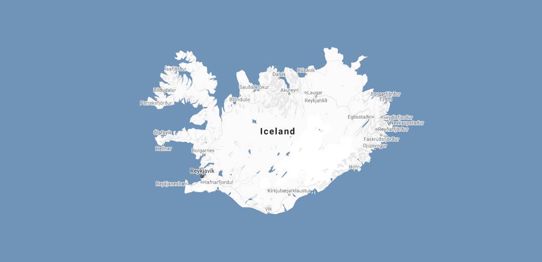
ヨークルスアゥルロゥン氷河湖
ヨークルスアゥルロゥン氷河湖は、アイスランド南東部の国道1号線沿いに位置する、氷山が浮かぶ美しい湖です。アイスランドで最も有名な氷河湖であり、国を代表する絶景スポットのひとつです。ここがなぜ特別な場所なのか、その魅力をご紹介します。 ヨークルスアゥルロゥン氷河湖は、アイスランドで最も人気のある自然観光地のひとつで、巨大な氷山がヴァトナヨークトル氷河から大西洋へと流れていきます。多くの旅行者が南海岸ツアーやリングロードのセルフドライブ旅行、またはアイスランド旅行パッケージで訪れ、近隣のダイヤモンドビーチやスカフタフェットル自然保護区などの見どころも一緒に楽しんでいます。 私たちのコンテンツが信頼できる理由 Guide to Icelandは、毎年何百万人もの旅行者をサポートするアイスランド最

9.6
14,740件のレビュー
5X37+PF Veiðilundur, アイスランド
ゴールデンサークル
ゴールデンサークルは、アイスランドで最も有名な観光ルートであり、1日で国の壮大な自然の驚異を巡る忘れられない旅へとあなたを誘います。アイスランドを訪れるなら絶対に外せない体験です! ゴールデンサークルは全長約300キロのループで、アイスランドの3つの美しい名所、シンクヴェトリル国立公園、ゲイシール地熱地帯、グトルフォスの滝を巡ります。近年では、ゴールデンサークルツアーの多くが、ケリズ火口湖を追加の立ち寄りスポットとして組み込んでおり、他にもさまざまなアクティビティが楽しめます。本ガイドではそれらも詳しくご紹介します。 私たちのコンテンツが信頼できる理由 Guide to Icelandは、アイスランドで最も信頼されている旅行プラットフォームであり、毎年何百万人もの旅行者をサポートしています
9.2
35,865件のレビュー
Sléttuvegur 8, 870 ヴィーク, アイスランド
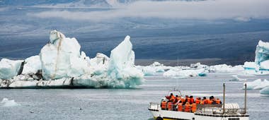
南海岸
なぜアイスランド南海岸が島内で最も人気のある観光地の一つなのか気になりませんか?火と氷が織りなす壮大な景観には、轟く滝、黒い砂浜、広大な氷河が広がり、忘れられない冒険があなたを待っています。 西のレイキャビクからヴァトナヨークトル国立公園まで伸びる南海岸は、アイスランドの自然美を存分に堪能できるエリアです。レンタカーでのドライブも簡単で、南海岸のガイド付きツアーも一年中人気。初めての方もリピーターも楽しめる、アイスランド旅行で外せないルートです。 道中のおすすめスポットが気になりますか?氷河湖から火山性のビーチまで、必見の観光地や旅のコツを詳しくご紹介します。南アイスランドで理想の冒険を計画しましょう。 私たちのコンテンツが信頼できる理由 Guide to Icelandは、毎年何百万人も

9.4
19,728件のレビュー
9CP532CF+5W
ヴァトナヨークトル氷河&国立公園
ヴァトナヨークトル氷河(アイスランド語表記:Vatnajökull)は、ヨーロッパ最大の氷河で、アイスランドの陸地の8%を覆っています。ヴァトナヨークトル国立公園の中心であり、ユネスコ世界遺産にも登録されています。 アイスランド南東部に位置し、ヴァトナヨークトルはスカフタフェットル自然保護区やヨークルスアゥルロゥン氷河湖からアクセスしやすく、どちらもレイキャビクから車で約4~5時間東にあります。 その巨大な規模から、多くのセルフドライブツアー、バケーションパッケージ、南海岸ツアーで訪れることができます。 レンタカーで旅をする方には、国立公園内でセルフドライブアクティビティや、スカフタフェットル発の氷河ハイキング、ヨークルスアゥルロゥン氷河湖ツアー、アイスケーブツアー、クリスタルアイスケーブ
9.2
25,757件のレビュー
Laugavegur 126, 105 レイキャビク, アイスランド
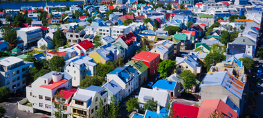
レイキャビク
レイキャビクは、アイスランドの小さくも活気あふれる首都で、世界でも類を見ない独自の文化を持っています。ここでは、アイスランドの首都が忘れられない理由と、絶対に見逃せないレイキャビクの観光スポットをご紹介します。 人口は約14万3千人と他の首都と比べて小規模ですが、レイキャビクには毎年多くの旅行者が何度も訪れたくなる魅力があります。活気あるグルメシーンと、アイスランドの大自然へのアクセスの良さ、そして多彩なレイキャビク発のツアーや体験が揃っており、充実した滞在が楽しめます。 私たちのコンテンツが信頼できる理由 Guide to Icelandは、アイスランドで最も信頼されている旅行プラットフォームで、毎年何百万人もの旅行者をサポートしています。すべてのコンテンツは、アイスランドを熟知した現地

アイスランド最大の旅行アプリをインストール
アイスランド最大の旅行アプリをスマートフォンにダウンロード。旅のすべてを1か所で管理できます。
アイスランド最大の旅行マーケットプレイスをポケットに。スマートフォンのカメラでQRコードを読み取り、表示されるリンクをクリックしてください。電話番号またはメールアドレスを入力すれば、SMSやEメールでもダウンロードリンクを受け取ることができます。


