Iceland is a European country, but its location tells a more layered story. The island sits directly on the Mid-Atlantic Ridge, the boundary between the North American and Eurasian tectonic plates. That boundary is easiest to see at Thingvellir National Park, a key stop on Golden Circle tours.
Culturally, politically, and historically, though, Iceland is firmly European and firmly Nordic.
Why You Can Trust Our Content
Guide to Iceland is the most trusted travel platform in Iceland, helping millions of visitors each year. All our content is written and reviewed by local experts who are deeply familiar with Iceland. You can count on us for accurate, up-to-date, and trustworthy travel advice.
For anyone preparing for a first trip to Iceland, this geological detail doesn't change much in practical terms. For flights, visas, and travel insurance, Iceland is treated the same way as any other Nordic country, so your trip will look the same as it would to anywhere else in the region.
What it does mean is that visitors get a rare bonus: the chance to stand on two continents at once. This guide explains why the country straddles two plates, where you can see and touch the boundary, and how to plan an Iceland vacation that takes full advantage of its unusual geography.
Key Takeaways
-
Iceland is a European country and part of the Nordic family, alongside Norway, Sweden, Denmark, and Finland.
-
Geologically, the country sits on the Mid-Atlantic Ridge, the boundary between the North American and Eurasian tectonic plates, making it the only landmass on Earth where the ridge rises above sea level.
-
The two plates pull apart by about 0.8 inches (2 centimeters) every year, demonstrating why Iceland is one of the most volcanically active countries on Earth.
-
The clearest places to see the boundary are Thingvellir National Park, the Silfra Fissure, the Bridge Between Continents on the Reykjanes Peninsula, and the Krafla area near Lake Myvatn.
-
Iceland is a member of the European Economic Area, the Schengen Area, and NATO, but not the European Union.
-
Beginning in 2026, travelers from visa-exempt countries (such as the US, Canada, the UK, and Australia) need to apply for ETIAS authorization before visiting Iceland.
Iceland Is a Nordic and European Country
 In almost every practical sense, Iceland is European. It's a member of the Council of Europe, the European Economic Area (EEA), the Schengen Area, and the North Atlantic Treaty Organization (NATO).
The country applied to join the European Union in 2009, suspended its membership talks in 2013, and still hasn't joined. The question of EU membership remains an active debate in Icelandic politics, but the choice is political rather than geographic, with roots in Iceland's long history of independence and self-government.
Iceland was settled in the 9th century by Norwegians and Celts and has stayed closely tied to its Scandinavian neighbors ever since. It was under Danish rule for over five centuries before gaining independence in 1944, but the cultural ties to its Nordic neighbors never weakened.
Iceland sits firmly within the Nordic family, alongside Norway, Sweden, Denmark, Finland, and the Faroe Islands. The Icelandic language is descended directly from Old Norse and is the closest modern language to the one spoken by the Vikings.
The country runs on Greenwich Mean Time year-round and follows the same European calendar as the rest of the region. Icelanders also share the same welfare-state model, the same obsession with coffee and licorice, and the same long summer days and dark winter ones as their cousins in Oslo and Copenhagen.
When the tournament season rolls around, Iceland plays in the Union of European Football Associations (UEFA) with the rest of Europe, not the Confederation of North, Central America and Caribbean Association Football (CONCACAF) with the United States and Canada.
Iceland Sits on the Mid-Atlantic Ridge
 The geology of Iceland is where things get strange.
The Mid-Atlantic Ridge is a giant underwater mountain range that runs down the middle of the Atlantic Ocean, from the Arctic Ocean all the way to the Southern Ocean. It marks the boundary between the North American plate and the Eurasian plate.
Along its length, new oceanic crust constantly forms as the two plates pull apart.
Iceland is the largest landmass on Earth where the ridge rises above sea level. That's because the country sits on a volcanic hot spot that pushes up magma fast enough to build an island on top of the ridge.
The result is a country split across two tectonic plates. The western third of Iceland sits on the North American plate, the eastern third sits on the Eurasian plate, and the middle is an active volcanic rift that technically belongs to neither.
The two plates pull apart by about 0.8 inches (2 centimeters) every year, which means Iceland is slowly getting wider. The same plate movement that shaped Thingvellir is also what makes Iceland one of the most volcanically active countries on Earth. Magma rising into the gap between the plates fuels the active volcanic systems in Iceland, and on average one erupts every few years.
Thingvellir: Walk Between Two Continents
The best place to see the two plates is Thingvellir National Park in the southwest of Iceland. It's a UNESCO World Heritage Site approximately 28 miles (45 kilometers) east of Reykjavik, and one of the three stops on the famous Golden Circle route.
Most travelers visit by joining Golden Circle tours or by following a Golden Circle driving guide on a self-drive trip.
At Thingvellir, you can walk through Almannagja, a deep rift canyon formed by the two plates pulling apart. Many Thingvellir tours start at the upper viewpoint and lead visitors down through the canyon on foot.
The towering cliff face beside the path marks the edge of the North American plate. The cliffs on the far side of the valley mark the edge of the Eurasian plate. The flat ground between them is a no-man's-land of fresh lava and slow-sinking earth.
Thingvellir is also the original site of the Althingi, one of the world's oldest still-functioning parliaments. Icelandic chieftains first met at Logberg, or the Law Rock, in 930 AD to settle disputes, pass laws, and declare outlaws.
The parliament moved to Reykjavik in 1844 but kept the same name. Logberg is still a place of national ceremony, and it’s where Iceland declared its independence on June 17, 1944.
If you'd like a guided introduction to the site, the park itself runs free ranger-led Thingvellir tours in English every day in June, July, and August. The morning tour starts at 10:00 from Thingvallakirkja Church, and the afternoon tour starts at 14:00 from the Visitor Center. Each lasts about an hour and covers the assembly site.
Silfra: Swim Between Two Continents
If walking between the plates isn't enough, you can also swim between them. Silfra is a rift at Thingvellir filled with crystal-clear glacial meltwater, narrow enough in places that a swimmer can stretch out and touch both continents at once.
The water in Silfra is filtered through lava rock for decades before it reaches the fissure, which makes it some of the clearest natural water in the world. Visibility reaches over 330 feet (100 meters) on a good day, and water temperature sits between 36 to 39 F (2 to 4 C) year-round, so it's the most popular spot for diving and snorkeling in Iceland.
Snorkeling is open to most visitors aged 12 and up who can swim comfortably and meet basic height and weight minimums. Scuba diving at Silfra has stricter requirements: Open Water certification plus either a dry suit certification or proof of at least 10 logged dry suit dives in the past two years.
Snorkeling tours run year-round and include all gear and a guide. For convenience, travelers can also opt for a Silfra snorkeling tour from Reykjavik, which includes hotel pickup, drysuit equipment, a PADI-certified guide, and underwater photos as a keepsake.
Bridge Between Continents
The Bridge Between Continents is a 49-foot (15-meter) steel footbridge built across a visible rift in the sand on the Reykjanes Peninsula. It's an unmistakable photo stop, and it does exactly what the name says: in about ten steps, you cross from North America to Europe.
As you walk across, you'll find plaques welcoming you to "America" on one side and "Europe" on the other, and a marker on the bridge that reads "The Bridge Between Continents: In the Footsteps of The Gods: Mid-Point."
Travelers who'd like a keepsake can collect a personalized certificate at the Reykjanes information center or the Reykjanes Geopark visitor center after their crossing.
The bridge sits at Sandvik, about 12 miles (20 kilometers) from Keflavik International Airport and 31 miles (50 kilometers) from Reykjavik. Visiting is free, parking is on site, and the stop usually takes 10 to 15 minutes. It pairs naturally with the Blue Lagoon or other Reykjanes attractions on a stopover or day trip.
Other Places Where the Two Plates Are Visible
 Thingvellir and Silfra are the most famous places to see the tectonic plates in Iceland, but they're not the only spots where the country's split is on display.
Reykjanes Peninsula
The Reykjanes Peninsula in the southwest is a long active section of the ridge, with steaming lava fields and fumaroles. The peninsula is best known internationally for the Fagradalsfjall eruptions, a series of volcanic events between 2021 and 2024 that drew thousands of visitors to watch fresh lava flow across the landscape.
Because it surrounds Keflavik International Airport, it's also the first piece of Iceland most travelers ever set foot on. Many of the best things to do on the Reykjanes Peninsula sit directly on or near the plate boundary, which makes the area a popular destination for layover or stopover tours.
Many Reykjanes tours depart regularly from Reykjavik, making it easy to visit even on a tight schedule.
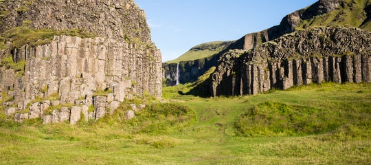
Krafla and Lake Myvatn
Up in the north of Iceland, the Krafla volcanic area sits right on the plate boundary near Lake Myvatn, with active fissures, bubbling mud pools, and the otherworldly Dimmuborgir Lava Field nearby. The whole area is one of the most geologically active spots in the country.
The region was also one of HBO's Game of Thrones filming locations in Iceland, doubling as Beyond the Wall throughout the series. The Grjotagja Lava Cave near Lake Myvatn appeared in Season 3, and the surrounding lava fields and snow-covered mountains turn up in several wildling scenes.
The Krafla and Myvatn region sits about 295 miles (475 kilometers) from Reykjavik, or roughly 56 miles (90 kilometers) east of Akureyri. Most travelers visit on a Ring Road trip in summer, when full road access is open, or as a side trip from Akureyri after a domestic flight from the capital.
What Iceland's Geography Means for Travelers

For immigration, aviation, and travel-insurance purposes, Iceland is European. As part of the Schengen Area, most visitors can stay in Iceland for up to 90 days within a 180-day period.
Beginning in 2026, however, travelers from visa-exempt countries (such as the United States, Canada, the United Kingdom, and Australia) need to apply for ETIAS authorization before their trip. Schengen visa holders and visa-required travelers should apply through Iceland's standard visa process well in advance.
The Keflavik International Airport operates as a European airport, and most European travel-insurance products cover Iceland without an extra charge. North American travelers often see the country as a natural halfway point between two continents, and many first-time visitors to Europe end up experiencing it through Reykjavik on the way to London or Paris.
Most trips to Iceland fall between three days and two weeks, depending on whether you're stopping over, exploring the southwest, or driving the full Ring Road. The ideal length for a trip to Iceland comes down to which regions you want to cover and how flexible your schedule is.
So for planning purposes, treat Iceland as a European destination. For map lovers and geology enthusiasts, the bonus is that you've also visited North America without leaving the country.
Plan a Trip to Two Continents in One Country
The cleanest way to stand on two continents in a single day is to go on a Golden Circle day trip from Reykjavik. You'll cross the plate boundary at Thingvellir, walk through Almannagja, and be back in the city by evening. Golden Circle tours run year-round in different formats and group sizes, so you can pick one that fits your schedule.
For travelers who want to see and swim between the plates in one outing, a Golden Circle and Silfra snorkeling combo tour pairs a guided sightseeing route with a drysuit snorkel at the fissure. Those who'd rather explore Thingvellir at their own pace can drive to the park independently and meet a guide for a Silfra snorkel tour on arrival.
To get to Thingvellir National Park from Reykjavik, follow Route 1 east and then turn onto Route 36 north. The drive typically takes 45 to 60 minutes, depending on traffic and weather. Parking is available near the main visitor areas, including Almannagja and Oxararfoss Waterfall.

Renting a car opens up Reykjanes, Krafla, and Lake Myvatn at your own schedule. A complete Ring Road trip takes about a week and crosses the plate boundary multiple times.
Other self-drive tours in Iceland cover shorter regional loops at different paces. A self-drive tour of the Ring Road, Snaefellsnes Peninsula, and other top attractions in Iceland, for example, can take up to 10 days.
Multi-day tours in Iceland offer guided alternatives for travelers who'd rather not drive. These are especially worth considering when visiting Iceland in winter. Icy roads, short daylight hours, and sudden storms can make self-driving across the country challenging.
Once you've stood on two continents at once, the rest of Iceland's geography starts to make more sense. The country's volcanoes, glaciers, and lava fields all trace back to the same forces that built the rift, and seeing them in person is the easiest way to understand the place that sits between two worlds.
Is Iceland part of Europe or North America?
Is Iceland on two continents?
Where can you see the two tectonic plates in Iceland?
Can you stand on both continents at the same time in Iceland?
Have you stood on both tectonic plates at Thingvellir, snorkeled at Silfra, or crossed the Bridge Between Continents? If not, which spot would you visit first to see the two plates meet? Share your experience in the comments below.

Born on the west side of Reykjavík and raised in the heart of downtown, I’ve spent most of my life surrounded by Iceland’s beauty. I’m a proud father of two and an avid traveler who has visited five continents—but Iceland remains, without a doubt, the most breathtaking place I know. I’ve traveled extensively throughout the country, exploring its hidden gems and natural wonders. My passion for Iceland and for helping others experience it led me to co-found Guide to Iceland, where we focus on connecting travelers with unique, local services and unforgettable adventures.