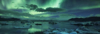
Complete Guide to the 2024 Sundhnukagigar Volcanic Eruptions


The Reykjanes peninsula has experienced ongoing volcanic activity in the past four years, with a total of nine eruptions in the surrounding area and five eruptions occurring in the Sundhnukagigar crater row since December 18th, 2023.
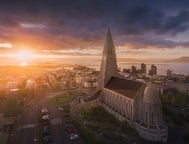
These eruptions are close to the town of Grindavik and have gained a lot of international attention. They have not come as a surprise to the Icelandic people, however, and they have made preparations to defend the nearby infrastructure from the volcanic forces. Daily life remains unaffected for most locals, and there are no risks for visitors to Iceland. Traveling to Iceland is safe, and flights remain unaffected during eruptions.
Read on to learn all about the regular eruptions of the Sundhnukagigar craters in 2024. The Reykjanes volcano area is currently closed off to the public - please consult the Safetravel website for further information about the closure. If you want to learn more about eruptions in Iceland, check out our article on the volcanic history of Iceland.
The area of the eruptions is still undergoing a larger volcanic event with the risk of new fissures opening in the vicinity. If you are in Iceland and wish to witness the eruption site, the only way is by taking a helicopter tour of the volcanic area. Please respect safety closures and do not attempt to hike to the Sundhnukagigar eruption site.
- Learn about the previous eruption in the Complete Guide to the Hagafell Eruption
- For information on 2023 eruptions, see the Complete Guide to the Eruption by Litli-Hrutur Volcano and the Complete Guide to the Sundhnukagigar Eruption
- See also: The Complete Guide to the 2021 Volcanic Eruption by Fagradalsfjall Volcano and the 2022 Fagradalsfjall Volcano Eruption
The February 8th Eruption at Sundhnukagigar
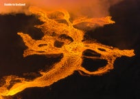
 The fissure that opened by the Sundhnukagigar crater row on February 8th was around 1.8 miles long (3 kilometers), with dramatic plumes of lava rising to heights of 164-196 feet (50-80 meters). Unlike the previous eruption in Hagafell, which had taken place close to the town of Grindavik, this new eruption is further north, with a lava flow heading mostly west.
According to the Icelandic Meteorological Office, the eruption was similar to the Hagafell eruption, although a little less powerful, and it followed a similar pattern to the previous Sundhnukagigar eruption of December 2023.
No lives were in danger from the eruption. However, the lava flow reached the Grindavikurvegur road and destroyed a water pipe that supplied the towns on the edge of the Reykjanes peninsula with hot water and heating. This led to around four days of no heating before a new pipeline could be established.
The lava flow did not cause damage to the town of Grindavik, the Blue Lagoon, or the Svartsengi power station, and construction crews had erected protective walls as preventative measures in response to the volcanic activity in the region. While the eruption was short-lived, the Sundhnukagigar area would not stay quiet for long.
The March 16th Eruption at Sundhnukagigar
 The eruption that began in Sundhnukagigar on March 16th gave very little notice of its forceful entry. The fissure was roughly 2 miles long (3.5 kilometers), and it quickly became apparent that it was more powerful than its February counterpart.
The lava flow from the eruption was initially very fast, flowing in two directions - the south and the west. Thankfully, the preventative measures of erecting mounds of earth to slow the lava flow proved useful in guiding it away from infrastructure. The lava flow stabilized within the first 24 hours, slowing down and forming craters.

The main concern of this eruption by Grindavik was the vegetation fires as lava spread over the dry landscapes. Notably, the flow filled up the Melholsnama mine, the source of the material used for the protective barriers that surround Grindavik, the Svartshengi powerplant, and Blue Lagoon.
The eruption maintained a consistent level of activity, characterized by a series of craters continuously erupting. By April 5th, activity had reduced to just one active crater. The eruption ultimately concluded on May 8th.
The May 29th Eruption at Sundhnukagigar
 It didn't take long for the next Sundhnukagigar eruption to take place as lava continued to collect underground. On May 29th, the ground on the Reykjanes peninsula opened for the fifth time in four years, forming a 2.1-mile (3,4-kilometer) long fissure. It was the most powerful eruption in this row of events so far, and lava spewed 164 feet in the air (50 meters) and extended the new lava field from previous eruptions.
This May eruption caused electricity outages in Grindavik, and lava flowed over the Grindavikurvegur and Nesvegur roads. In one spot, some lava went over one of the protective barriers and was cooled down with water. Thankfully, locals were able to stop the flow and fix the barriers.
The volcanic activity lasted for a while but developed similarly to the previous eruptions, slowing down after the first few days. It was officially declared over on June 22nd.
The August 22nd Eruption at Sundhnukagigar
 Around 9 PM on August 22nd, there was a sudden increase in earthquakes around the Sundhnukagigar craters before the earth opened up for the ninth time in four years. Small earthquakes were felt around the Capital Area, including one that measured 4.1 in Magnitude.
The erupting fissure quickly extended to 2.5 miles (4 kilometers) in length, and a few hours later, another smaller fissure opened further to the north, measuring around 0.6 miles in length (1 kilometer). At that point, the earthquakes calmed down as pressure was released from the earth.

To begin with, the lava flow was around 1.2 miles (2 kilometers) per hour but quickly slowed down. The activity is also centered more on the north of previous eruption sites, a more convenient location for protecting nearby infrastructure, but it raised some new challenges.
The area was used as a practice site by the United States Army between 1952 and 1960 and is known to hide remains of weaponry, including still active landmines. This meant that if people chose to ignore the safety closure and tried to hike to the eruption area, there was a chance that they would get injured on the way while crossing the area.
Thankfully, most people respected the closure, and the eruption finally came to an end on September 5th. It would be almost two months until the next one.
The November 20th Eruption at Sundhnukagigar
 After weeks of no activity, the Earth by Sundhnukagigar opened for the 7th time on the evening of November 20th. This marked the 10th eruption on the Reykjanes peninsula since Fagradalsfjall volcano in 2021.
As with the previous eruption, the craters opened further north of Grindavik, sparing nearby infrastructure from direct threats. However, the lava flowed over the main road to Grindavik and severed some power lines, causing a temporary electricity outage in Grindavik. It also flowed over the parking area of the Blue Lagoon, but thanks to the protective barriers around the area, there was no risk to the spa or other infrastructure.
The volcanic fissure reached a length of 3 kilometers (1.8 miles) overnight but then started forming craters, and activity slowed down. Flights and travel within Iceland remained unaffected, and daily life for locals continued as usual.
This November eruption came as a surprise, as scientists had recently predicted that volcanic activity wouldn't resume until December at the earliest. However, the eruption came to a close on December 9th, having lasted for 18 days.
Based on the recent patterns, more eruptions are likely in the coming months, though the timing remains unpredictable. The eruption site is currently off-limits to the public and can only be viewed through helicopter tours.
Events Preceding the Eruptions

The eruption in Hagafell in January had come as a terrible blow to the people of Iceland, especially the inhabitants of Grindavik, whose homes were ravaged by the seismic activity. The flowing lava destroyed three houses, and many other homes and infrastructure were destroyed by enormous cracks in the earth created by earthquakes and seismic activity.
Thankfully, no people or animals were harmed in the eruption as everyone had been evacuated. The preceding earthquakes, which numbered in the thousands, had given the Icelandic people fair warning and an eruption had been expected for roughly two months.
Just a few months before the eruption in Hagafell, another eruption that took place in Sundhnukagigar had resulted in what experts called a "best-case-scenario," as the lava flow from the eruption, while close to Grindavik flowed in the opposite direction of the town.
Whether or not Grindavik will be inhabitable in the future remains unseen, but it is clear that the inhabitants will, at the very least, not return to their homes in the coming months.

The series of eruptions in Reykjanes began in 2021 with the volcano of Fagradalsfjall. The eruption was a visitor-friendly spectacle with tens of thousands of people flocking to see it from all over the world. The same was true for the second eruption by Fagradalsfjall in 2022 and the eruption of Litli-Hrutur in 2023.
The seismic activity in Reykjanes is caused by its location on the Mid-Atlantic ridge, the rift between the North American and Eurasian tectonic plates. If you want to learn more about the geology behind the eruptions, see our article on tectonic plates in Iceland.
The volcanic activity of the Reykjanes peninsula is expected to continue developing in the coming years. Have you managed to see any of them during a visit to Iceland? Let us know in the comments if you have any questions, and we will do our best to answer them!


関連記事


アイスランドのブルーラグーン完全ガイド
アイスランドが誇るブルーラグーンの魅力を、すみずみまでご紹介します。この完全ガイドでは、ブルーラグーンの基本情報から、アクセス方法、営業時間、おすすめの訪問時期まで、旅の計画に必要な情報をすべて網羅しています。このガイドを参考に、素晴らしいブルーラグーン体験の準備を整えてくださいね。 ブルーラグーンは、アイスランドを代表する地熱温泉として世界的に知られています。乳白色に輝く...もっと読むアークレイリのおすすめアクティビティ13選(周辺エリアも)
アークレイリとその周辺エリアのおすすめ観光名所やアクティビティ13選をご紹介します。アイスランドの「北の都」と呼ばれるこの街では、ホエールウォッチングやスキーといったアクティビティや、ビールスパのようなちょっと変わった体験まで、様々な遊び方ができます。アークレイリから日帰りで行ける観光地や、夏・冬それぞれの人気アクティビティをまとめました。 アークレイリ(Akureyri)は首都レイキャビク...もっと読む
アイスランドの春|完全旅行ガイド
春のアイスランド旅行をお考えですか?アイスランドの大自然が目覚める春はとても素敵な季節です。草花が芽吹き、鳥のさえずりが響き渡り、島中が期待に満ちています。オーロラもまだ見られます。 アイスランドの春は3月から5月までです。日が少しずつ長くなり、雪が解け始め、旅行時期によってはオーロラも見られます(オーロラは冬がベストシーズンですが4月中旬くらいまで見られます)。レンタカーでドライブに出かけ...もっと読む


アイスランド最大の旅行アプリをスマートフォンにダウンロード。旅のすべてを1か所で管理できます。
アイスランド最大の旅行マーケットプレイスをポケットに。スマートフォンのカメラでQRコードを読み取り、表示されるリンクをクリックしてください。電話番号またはメールアドレスを入力すれば、SMSやEメールでもダウンロードリンクを受け取ることができます。