The Ultimate Guide to the Highlands of Iceland | Where They Are and How to Visit


What makes the Icelandic Interior Highlands so beloved by locals and guests alike? What popular attractions can be found in the Highlands, and what activities can be undertaken there? Why can the Highlands only be visited during the summer months? Read on to find out all you need to know about the Highlands of Iceland.
- Experience Icelandic nature with a 6 Day Camping Road Trip
- Reach great new heights on this Ultimate 10 Day Adventure
- Discover our list of the Top 5 Places to Visit in the Highlands of Iceland
Introduction to the Icelandic Central Highlands

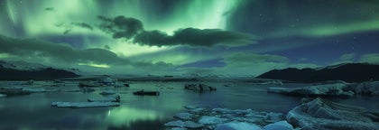
The Interior Central Highlands, known as 'Hálendið' to locals, sit 400–500 metres (1300–1600 feet) above sea level, their domineering mountain peaks piercing into the clouds, their colourful rhyolite hillsides inspiring all that see them. Steam rises from the region's vast array of geothermal hot spots, and ancient rivers intercut the landscape with decorative ease.
Yes, without doubt, the Highlands is a place of beauty, mystery and drama, an area rich in natural delights, hiking trails and incredible scenery.
With no permanent inhabitants—save, perhaps, the odd Arctic Fox—no shops, and no tarmacked roads, the Highlands are as stunning as they are inhospitable, taking on an unwelcoming shine during winter, given the ferocity of wind here, and the sheer amount of snowfall.

If visiting the Highlands in winter wasn't already impossible, it would be unbelievably reckless, an affront to respecting Iceland's nature and one's own safety. In short; don't even try it!
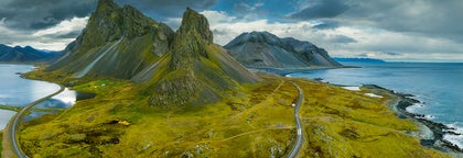
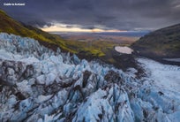
Not only do the Icelandic Highlands contain three of the country's biggest glaciers (Vatnajökull, being the biggest, Hofsjökull in the centre, and, of course, Langjökull) it also holds its highest peak, Hvannadalshnúkur.
South of the glaciers, visitors will experience the Highlands as a plethora of colourful tuff mountains, whilst to their North, vegetation begins to subside for black volcanic rock and dark layers of ice. This, hopefully, gives you an idea of the sheer amount of land the Highlands cover, in total 40,000 square km (15,444 square miles).
In fact, there is a local petition to turn the entirety of the Icelandic Highlands into one enormous National Park. Currently, 35% of the area, or 14,000 square km, are protected as a National Park or Nature Reserves. The largest one being Vatnajökull National Park, but other large Nature Reserves include Þjórsárver, Guðlaugstungur and Fjallabak.
With 10 glaciers, more than 15 geothermal areas, dozens of active volcanoes, hundreds of lakes, numerous craters, deserts and stunning gorges, it would be impossible to cover all the natural beauty there is to be seen in one article, or in one trip. So you'll only find some of the most noteworthy attractions here.
A word of advice, the Icelandic Highlands can only be visited in the summertime, and most roads leading to them are only open from June, or perhaps even early July. Be sure to check road conditions on Iceland's Road Website before planning a trip. Also note that a 4WD car is necessary to reach the Highlands, as you'll mostly be driving on gravel roads, so-called F Roads, and may need to cross some unbridged rivers in some cases.
Those that have not crossed unbridged rivers before are advised to go on tours or with 4WD buses to their destination for safe arrival.
- See also: The Ultimate Guide to Driving in Iceland
Landmannalaugar ("The People's Pools")

When most think of the Central Highlands, the first images conjured to the mind are that of Landmannalaugar (“the people’s pools”), an area so named thanks to the vast array of natural hot springs that can be found amidst its kaleidoscopic hillsides and sweeping canyons.
This stunning geothermal area with its colourful rhyolite mountains is situated within the Fjallabak Nature Reserve, protected since 1979 due to its immense beauty.
In the past, this area was famed for its usefulness, especially for passing travellers and shepherds who could utilise the pools for defrosting (both the sheep and themselves). Today, the area is perhaps best known as Iceland’s premier hiking area, though visitors should always bring a towel and swimsuit with them in case an instinct to bathe arises.

Landmannalaugar contains numerous exciting routes for the avid trekker, including Laugavegur—not to be confused with Reykjavík’s main shopping strip—which is widely considered to be the most scenic hiking route in Iceland. Landmannalaugar sits on the northern end of this famed trail.
- See also: Hiking in Iceland

Landmannalaugar area paints a stark contrast to the dark Laugahraun lava field, formed in 1477 and located just above it, thanks to the wealth of mountains made of rhyolite; an amazing rock which creates a full spectrum of colour, from pink to green to yellow, and appears to change tone and shade in the passing light.
This effect makes Landmannalaugar one of the more unique places in the country, complimented all the more by its isolation and wild character.
Thorsmork ("Thor's Forest")

Þórsmörk valley is a Nature Reserve nestled directly between three of Iceland's most staggering glaciers: Eyjafjallajökull, Mýrdalsjökull and Tindfjallajökull. As the name suggests, this valley is titled after the Norse God of Thunder, Thor. It certainly lends itself to a similar drama...
Due to the valley's sheltered position, Þórsmörk is known to boast a warmer climate than what is typical of the rest of the country, leading to a blossoming of vegetation, including birchwood and ferns.
The valley makes up the southern half of the Laugavegur hiking route, as well as parts of the Fimmvörðuháls hiking trail which leads its trekkers 30 kilometres across the hills that sit at Eyjafjallajökull's base.
- See also: Glaciers in Iceland

The 2010 eruptions of Eyjafjallajökull saw Þórsmörk in springtime covered with a thick layer of volcanic ash. These eruptions, of course, are most widely known internationally for shutting down European air traffic, as well as sparking a renaissance in foreign reports mispronouncing the word "Eyjafjallajökull" (its ay-yah-fyad-lah-yer-kuh-tel).
After the eruptions struck, the area needed a number of months in order to restore itself back to its usual glory. Today, Þórsmörk is rightfully considered to be one of the must-see areas of the Central Highlands.
- Book the Hiking in Thorsmork Valley | Super Jeep Day Tour here
This birch-clad valley with its black rock formations is hard to reach, as visitors need to traverse the ferocious and unbridged Krossá river. First-time visitors are advised not to attempt the drive themselves, but fortunately, there are regular buses going to Þórsmörk during summertime, as well as a variety of Super Jeep Tours.
This is an exceptionally romantic location to visit, and if you're not one for camping, then there is both a glamping option and an indoor sleeping option at a hut available at Volcano Huts.
- See also: The Most Romantic Places in Iceland
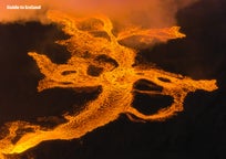
Lakagigar ("The Laki Craters")
 Laki, otherwise referred to as Lakagígar (“the craters of Laki”) is, perhaps, South Iceland’s most famous volcanic fissure, making up a part of the Grímsvötn system and surrounded by picturesque green and black plains. The fissure can be found in close proximity to Kirkjubæjarklaustur village and Eldgjá canyon.
Laki’s most infamous and violent eruptions occurred between June 1783 and February 1784. The resulting outcome could not have been more horrifying.
- See also: The History of Iceland
50% of the island’s livestock perished under the ash clouds, leading to a famine that would eventually kill one-quarter of the Icelandic population, the lava flow having decimated over twenty villages. During this eight-month period, Laki ejected 42 billion tons of basalt lava.
The eruptions even had consequences in other parts of the world. Given the fact that 120 millions tons of sulphur dioxide were poured into the Northern Hemisphere, global temperatures dropped significantly. This caused a change in the monsoon seasons of Africa and India, as well as crop failure across Europe. Many consider the Laki eruptions to have been the catalyst for the French Revolution of 1789.
English naturalist, Gilbert White, wrote of the time in his personal journals, “By my journal I find that I had noticed this strange occurrence from June 23 to July 20 inclusive, during which period the wind varied to every quarter without making any alteration in the air.
 Photo from Sightseeing Flight Over Laki Craters, Glaciers and Highlands
- See also: Witchcraft and Sorcery in Iceland
The sun, at noon, looked as blank as a clouded moon, and shed a rust-coloured ferruginous light on the ground, and floors of rooms; but was particularly lurid and blood-coloured at rising and setting. All the time the heat was so intense that butchers' meat could hardly be eaten on the day after it was killed; and the flies swarmed so in the lanes and hedges that they rendered the horses half frantic, and riding irksome ”

Photo from Sightseeing Flight Over Laki Craters, Glaciers and Highlands
However nowadays there are no signs of volcanic activity in the area, and Laki Craters became a Nature Reserve in 1971. If you visit this spectacular region you can admire a 25km long row of moss-covered craters, where the bright green moss is in stark contrast to the jet black craters and lava field.
As the roads to reach Laki craters are especially rough to traverse, then an easier way to see this natural phenomenon is to do so from air. Driving yourself definitely requires a 4WD car, and then you can explore on foot.
Eldgja Canyon
 Photo from Wikimedia, Creative Commons, by Ilya Grigorik. No edits made.
Eldgjá is the largest volcanic canyon in the world and can be located directly between the village of Kirkjubæjarklaustur and the hiking paradise that is Landmannalaugar. Stretching an incredible 40 kilometres, Eldgjá is 270 metres at its deepest, and 400 metres at its widest.
The canyon was discovered by Icelandic geologist and geographer, Þorvaldur Thoroddsen, a man famed for his passionate academic excursions into the wilds of Iceland's nature.
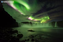
- See also: Top 10 Beautiful Waterfalls of Iceland
Inside of the chasm, guests can look upon the waterfall Ófærufoss. Ófærufoss once had a natural rock bridge that spanned the full falls, making the site appear as though it had been plucked straight out of the pages of fantasy. Today, the bridge has eroded away due to excess glacial flooding.
 Photo from Wikimedia, Creative Commons, by Natalie Carioni. No edits made.
In March 2018, a group of medieval researchers from the University of Cambridge came up with the hypothesis the Icelandic poem, Völuspá, was in fact written about the 939 AD eruption of Eldgjá. Given the poems visceral imagery and dramatic, descriptive storytelling, it is thought visions of this eruption were invoked in order to speed up Iceland's transformation from a Pagan to a Christian country.
Herdubreid Mountain
 Photo from Wikimedia, Creative Commons, by Heidi Soosalu. No edits made.
The year 2002 saw Herðubreið voted Iceland's 'National Mountain'. Because of its distance from the populace in contrast to say, Mount Esjan, which sits directly overlooking the capital city, it is something of a testament to Herðubreið's beauty that it has won such a title. Well, nothing less fits for what is colloquially referred to as "The Queen of Icelandic Mountains."
Herðubreið (meaning 'Shoulder Wide') is a table-top mountain, known in Icelandic as "Stapi", and summits at an impressive 1682 metres (5518 ft). Its height is made all the more awe-inspiring by its flat surroundings, the empty lava fields of Ódáðahraun, that truly help to present the mountain in all its natural grandeur.
- See also: Mountains in Iceland
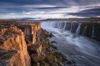
Aldeyjarfoss Waterfall
 Photo from 7 Hour Off-Road Tour of North Iceland's Waterfalls with Aldeyjarfoss and Transfer from Akureyri
Dropping 20 metres from the Skjálfandafljót river, Aldeyjarfoss is one of the Highlands' most beautiful waterfalls. It is particularly distinguished for the giant basalt columns that surround the cascading water, as well as the white shade of the water itself.
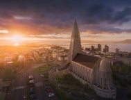
These basalt columns, typical of many waterfalls around Iceland, have done much to artistically inspire some of Iceland's most iconic architecture, including the two churches Hallgrímskirkja, in Reykjavik, and Akureyrarkirkja, in the "Capital of the North", Akureyri.
As is clearly visible from the above video, Aldeyjarfoss is particularly beloved by the world's kayakers, thanks in large part due to the fact that the waterfall once took centre stage for the longest free fall in a kayak, as recorded by Guinness World Records. The reason why the waterfall is considered infamous is due to the number of injuries sustained by kayakers attempting the free-fall.
These characteristics of Aldeyjarfoss make it a true photographic gem; because of the waterfall's narrow opening and its large, circular basin, giving the feature an otherworldly appearance.
Hekla Volcano
 Photo by Tom Podmore
In Iceland, Hekla is sometimes referred to as "the entry to hell” or even hell itself, which gives some idea as to this volcano’s menacing influence over the preceding centuries.
Those living in the middle-ages, in fact, considered the volcano to be the underworld's entrance, referenced in such literature as Herman Melville's Moby Dick, William's Blake poem Winter, and in the Icelandic Symphony, Hekla OP 52, considered one of the loudest compositions in Classical Music.
Since the initial settlement period, approximately around 870 AD, Hekla has erupted over twenty times, causing untold devastation to development in Iceland, as well as cementing an ever-permeating fear that this giant may soon rumble again.
Hekla's last eruption occurred in the year 2000, welcoming in the new millennium with a fiery reminder of its presence.
When not immediately threatening the local population, Hekla is utilised as a natural visitor attraction, offering a number of hiking and mountaineering routes, as well as skiing and snowmobiling in the winter months.
In other words, Hekla doesn't just have to bring the adventure to you (...if we can call an eruption an adventure), but the adventure can be brought directly to its steep, domineering slopes.
Kerlingarfjoll Mountains

Kerlingarfjöll is a range of mountains stretching 367 square kilometres through the Interior Central Highlands, known most famously for containing the region's third largest geothermal area, Hveradalir.
This bubbling, burning energy points directly to the mountain range's volcanic origins and is further proved by the dark red colouring of its rhyolite stones.
Kerlingarfjöll was once known as Iceland's premier summer ski resort, though this project was dismantled in 2000 due to the fact that Iceland's rising temperatures frankly made it unfeasible. There was simply not enough snow. Now, Kerlingarfjöll operates as a Highlands Resort, offering food and accommodation services to those in the area.

Not far from Kerlingarfjöll Mountain Resort is the area Hveradalir, where fuming hot springs can be found amidst the glaciers. In order to reach this area, you will begin from the Kerlingarfjöll resort, hiking 4km (2.5 miles) over easy terrain... (crampons are unnecessary for the hike, despite the fact some areas of the trail will be covered with snow. It is highly recommended to wear sturdy hiking shoes and even bring walking poles).
Take note that the route is not marked, though the trail is clear. Upon arrival, you will find yourself in an untouched geothermal region, surrounded by the Kerlingarfjöll mountains. Alternatively, you can drive for about 10-15 minutes to Hveradalir, and go for shorter hikes in the area there.
As of March 2017, the Icelandic media reported that the mountain range was to become an officially protected Nature Reserve, as managed by the state. This was an enormous victory for Icelandic environmentalists and nature lovers, given previous plans to utilise the area's geothermal energy into a new power plant.
You can read more about some of the issues facing Icelandic nature in our articles: Iceland's Troubled Environment, Sustainable Tourism in Iceland and Rivers For Sale | The Future of Iceland's Water Systems.
Hveravellir Nature Reserve

Considered to be one of the great wilderness reserves left on earth, Hveravellir offers stunning landscapes and fascinating examples of geothermal energy. Hveravellir translates to “Hot Spring Fields”, though is widely referred to as an “oasis” in the Highlands.
Hveravellir is found between the glaciers, Langjökull and Hofsjökull, its borders extending up the foothills of the former. An ancient route can be traced going through the area, dating back to the year 900; this road is known as Kjalvegur.
As one of the country's largest geothermal areas, Hveravellir truly provides a wealth of hot springs, some of which can be relaxed in, others require your appreciation from a safe distance.
When we talk of steaming fumaroles, bubbling mud cauldrons and hot springs, there really can be no better place in Iceland, save perhaps Haukadalur, to see such energy at work.
- See also: Things That Can Kill You in Iceland

Want to see the "Blue Hot Spring" (Bláihver), the "Green Hot Spring" (Grænihver) or the "Red Hot Spring" (Rauðihver)? They're all found here. Along with "Beautiful Hot Spring" (Fagrihver) and "Old Beautiful Hot Spring" (Gamli Fagrihver).
 Photo by Regína Hrönn Ragnarsdóttir
The oldest descriptions of Hveravellir can be dated back to the year 1752 after it was recorded in the travelogues of Eggert Ólafsson and Bjarni Pálsson. These two travellers were also responsible for naming the hot spring, Öskurhóll, as “The Roaring Mound” due to the whistling sound it made.
 Photo by Regína Hrönn Ragnarsdóttir
At Hveravellir, there is a hot pool located right beside the visitor’s centre. This hot pool makes for a fantastic and civilised stop for some bathing, measuring out at 8 - 39 degrees C, and was first constructed in 1950. Beware of sitting too close to the pool’s input pipe, however, as this gets incredibly hot, and don’t expect any changing facilities… this is Iceland, after all.
Located on the edge of a lava field, just over an hour's drive from the gorgeous mountains of Kerlingarfjöll, this geothermal area is one of the best places in Iceland to understand and see first-hand just how this land's volcanic underbelly continues to sculpt the natural environment.
Langisjor Lake
Whilst notoriously difficult to access, Langisjór is, without doubt, one of Iceland's most picturesque lakes, framed on each side by a dazzling line-up of mountains and lush hillsides.
Those lucky and organised enough to visit it, however, will find themselves in one of the most scenic locations in the whole of the central Highlands.
The lake covers 26 square kilometres in total, measuring up to 20 kilometres in length and up to 2 kilometres in width. The lake's ultimate depth is 75 metres. Langisjór can be located on the southwestern border of Vatnajökull National Park.

Over recent years, a number of environmental groups in Iceland have expressed their deep concern at government proposals to construct an industrial dam on the lake.
The reason for its proposed location is its distance from civilisation, though campaigners worry that by continuing to forgo the sanctity of Iceland's environment for industrial progress, the country will lose one of the essential values it holds so dear; protecting the land.
Bardarbunga Volcano

Deeply enclosed within the icy casing of Vatnajökull glacier, Bárðarbunga was, until recently, little-known within the pantheon of Icelandic subglacial stratovolcanoes. Something of a surprise, considering Bárðarbunga is Iceland's second largest mountain.
Well, that's what one gets for hiding beneath the country's glacier... no one tends to notice you... until you decide to go off.
Bárðarbunga volcano put on a good volcanic show when it erupted in August 2014, a volcanic eruption that lasted for 6 months, from the 29th of August 2014 until the 27th of February 2015.
Changes in perception came with scientific studies, studies that quickly revealed surrounding tephra layers to have been ejected from Bárðarbunga, rather than another, nearby volcano, as previously believed.
Today the area is interesting to visit as visitors can clearly see the brand new lava as it reshaped the landscape only a few years ago. But it's not very accessible and very few people venture there.
- See also: National Parks in Iceland
Did you enjoy our article about the Icelandic Central Highlands? What attractions are you looking to visit, and if you've already been, what was your favourite? Is there anything crucial from your own experience that you feel we have left out? Make sure to leave your thoughts and queries in the Facebook Comment's box below.


บทความอื่นที่น่าสนใจ


11 ของฝากยอดนิยมจากไอซ์แลนด์
ภาพโดย Jórunn คุณกำลังสงสัยอยู่ใช่ไหมว่ามาไอซ์แลนด์ควรซื้ออะไรเป็นของฝาก? หากคุณกำลังอยากรู้ว่าของที่ระลึกแบบไหนที่ทำให้นึกถึงไอซ์แลนด์และของแบบไหนที่จะเป็นเครื่องเตือนถึงความทรงจำอันมีค่าของคุณที่ไอ...อ่านเพิ่ม
คู่มือฉบับสมบูรณ์เกี่ยวกับการปะทุของภูเขาไฟลิทลิ-ฮรูตูร์ในปี 2023
เรียนรู้ทุกสิ่งที่คุณจำเป็นต้องรู้เกี่ยวกับการปะทุของภูเขาไฟลิทลิ-ฮรูตูร์ (Litli-Hrutur) ในไอซ์แลนด์ในปี 2023! พื้นที่ที่เกิดการปะทุใหญ่แค่ไหน? การเยี่ยมชมภูเขาไฟตอนนี้ปลอดภัยหรือไม่? วิธีที่ดีที่สุดใ...อ่านเพิ่ม
การแต่งกายในไอซ์แลนด์ในแต่ละฤดูกาล
ไอซ์แลนด์มีชื่อเสียงในด้านสภาพอากาศที่เปลี่ยนแปลงตลอดเวลา โดยมีฤดูหนาวที่ไม่รุนแรงและมักมีฤดูร้อนที่เย็นสบายและมีลมแรง การจัดกระเป๋าไปประเทศที่เทพเจ้าแห่งสภาพอากาศมีแนวโน้มที่จะอารมณ์แปรปรวนอาจดูน่ากั...อ่านเพิ่ม


ดาวน์โหลดตลาดการท่องเที่ยวที่ใหญ่ที่สุดของไอซ์แลนด์ลงในโทรศัพท์ของคุณเพื่อจัดการการเดินทางทั้งหมดของคุณได้ในที่เดียว
สแกนรหัส QR นี้ด้วยกล้องในโทรศัพท์ของคุณแล้วกดลิงก์ที่ปรากฏขึ้นเพื่อเพิ่มตลาดการท่องเที่ยวที่ใหญ่ที่สุดของไอซ์แลนด์ไว้ในกระเป๋าของคุณ ป้อนหมายเลขโทรศัพท์หรือที่อยู่อีเมลของคุณเพื่อรับ SMS หรืออีเมลพร้อมลิงก์ดาวน์โหลด