This Guide to Iceland analysis brings together 135 years of published measurements and research to examine how quickly Iceland’s glaciers are shrinking. It covers changes in glacier mass, area, thickness, and ice-front positions between 1890 and the 2024/25 period.
Glaciers still cover about 10% of Iceland and shape many of its best-known landscapes. They support popular experiences such as glacier hiking tours, snowmobiling tours, ice cave tours, ice climbing tours, and glacier lagoon tours.
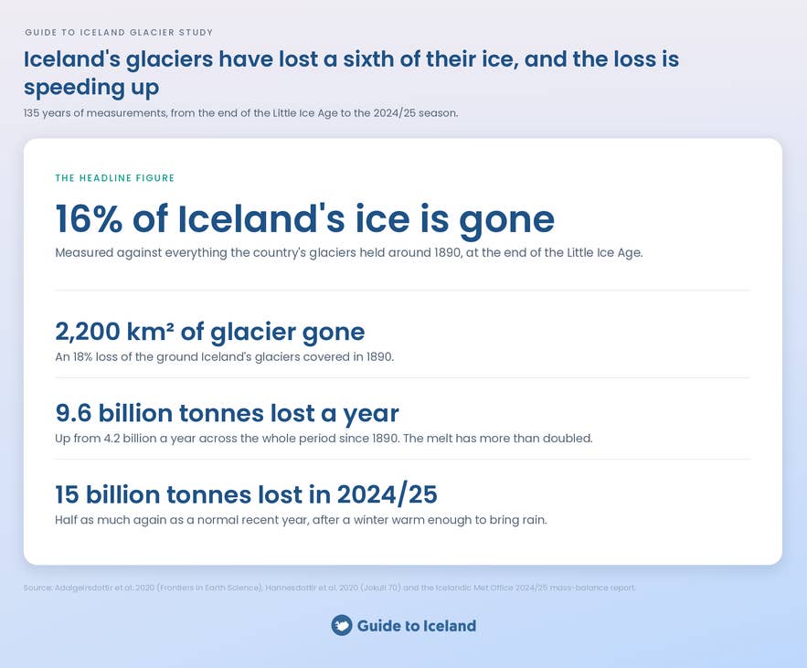
The findings show that Iceland lost about 540 billion tonnes of glacier ice between 1890/91 and 2018/19. The pace has accelerated in recent decades, and the 2024/25 period alone brought a loss of more than 15 billion tonnes.
The sections below compare long-term and annual losses, identify the ice caps that have changed most, and show how retreat is reshaping the South Coast. They also explain what future projections indicate and how travelers can still visit Iceland’s glaciers safely.
Cite this study
Key Findings
-
Long-term ice loss: Iceland lost about 540 billion tonnes of glacier ice between 1890/91 and 2018/19. That equals approximately 16% of the country’s 1890 glacier mass.
-
Shrinking glacier area: Iceland’s glaciers covered about 18% less land in 2019 than at their late-19th-century maximum. During the first two decades of this century, their area decreased by around 40 square kilometers per year.
-
Faster annual losses: Iceland’s glaciers lost an average of 9.6 billion tonnes per year between 1994/95 and 2018/19, more than twice the long-term average. The 2024/25 period recorded a loss of more than 15 billion tonnes.
-
Uneven losses among major ice caps: Langjokull lost the greatest share of its 1890 mass at around 29%, followed by Hofsjokull at approximately 25%. Vatnajokull recorded the smallest proportional loss at about 12%.
-
Visible changes on the South Coast: By 2010, Solheimajokull’s front was about one kilometer farther up the valley than in 1930. Jokulsarlon grew from 7.6 to 27.2 square kilometers between 1982 and 2018 as Breidamerkurjokull retreated.
-
Further losses are projected: Iceland’s three largest ice caps are expected to remain through 2100, but all could lose substantial mass. Projections indicate that Iceland’s glaciers overall may lose about half their volume by the end of the century.
How Was This Analysis of Iceland’s Glaciers Conducted?
Guide to Iceland reviewed published scientific studies, national glacier records, and official monitoring reports. Together, these sources cover changes in the amount and thickness of ice, the area covered by glaciers, and how far they have advanced or retreated. They also provide estimates of future ice loss.
For the long-term picture, the analysis relies mainly on a 129-year reconstruction of glacier changes in Iceland. Changes in glacier area were checked against the national inventory of Iceland’s glaciers through 2019.
To bring the record up to date, the analysis uses the Icelandic Met Office report on glacier ice loss in 2024/25. More detailed studies and local monitoring reports provide information about individual glaciers, including those on the South Coast.
Future figures are estimates rather than direct measurements. They come mainly from projections discussed in the 129-year reconstruction and the Melting Glaciers project’s outlook for Iceland’s ice cover.
How Much Ice Has Iceland Lost Since 1890?
A 129-year study of glacier loss in Iceland estimates that the country’s glaciers lost about 540 billion tonnes of ice between 1890/91 and 2018/19. This was approximately 16% of the ice they held in 1890 and enough to raise global sea levels by about 1.5 millimeters.
This loss is also reflected in the shrinking area covered by glaciers. A national inventory of changes in Iceland’s glacier area found that they covered about 10,400 square kilometers in 2019. This was more than 2,200 square kilometers, or 18%, below their late-19th-century maximum of roughly 12,600 square kilometers.
During the first two decades of the 21st century, Iceland’s glacier area decreased by an average of approximately 40 square kilometers per year. The inventory also found that tens of small glaciers disappeared entirely during that period.
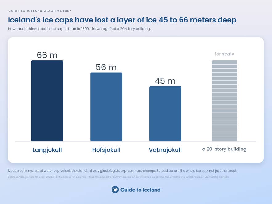
The 129-year study also examined mass loss from Iceland’s three largest ice caps. Vatnajokull lost enough ice to equal a 45-meter-deep layer of water spread across its area. The equivalent depths were 56 meters for Hofsjokull and 66 meters for Langjokull. For perspective, these depths are comparable to the height of a 15- to 20-story building.
How Fast Are the Glaciers in Iceland Melting?
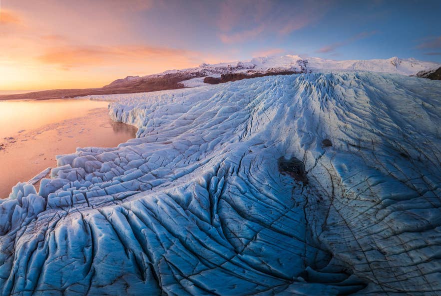
The 129-year study found that Iceland’s glaciers lost an average of 9.6 billion tonnes of ice per year from 1994/95 to 2018/19. This was more than twice the annual average for the full study period beginning in 1890.
The fastest period of sustained loss was from 1994/95 to 2009/10, when the glaciers lost an average of 11.6 billion tonnes each year. More recent figures show that the annual loss has since climbed even higher.
An Icelandic Met Office report on glacier ice loss in 2024/25 recorded a loss of just over 15 billion tonnes. Vatnajokull accounted for nearly 11 billion tonnes, while Hofsjokull and Langjokull lost close to 3 billion tonnes combined.
The Icelandic Met Office linked this loss to unusually warm autumn and winter conditions. More precipitation fell as rain instead of snow, and the following summer was one of the warmest since measurements began.
The report also indicates that the period of slower mass loss from 2012 to 2020 has ended. Iceland’s glaciers are again losing mass at rates similar to those recorded between 1995 and 2011.
Which Glaciers in Iceland Are Melting the Fastest?
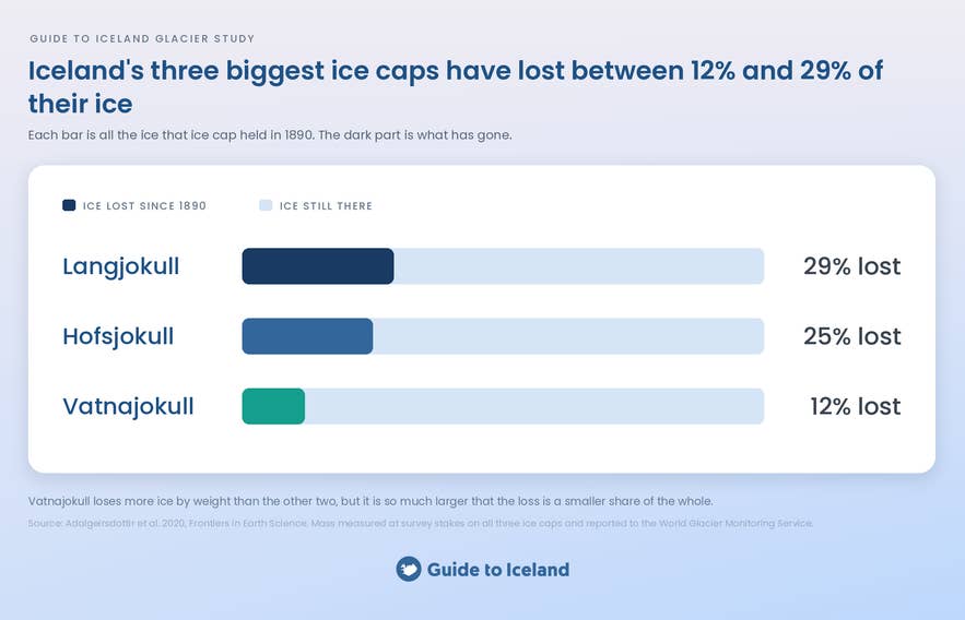
The 129-year study found that Langjokull lost the largest share of its 1890 mass among Iceland’s three largest ice caps, at about 29%. Located in the Western Highlands, it is Iceland’s second-largest ice cap and the setting for many snowmobiling tours.
Vatnajokull lost the smallest share of the three, at about 12%. It covers a large part of Southeast Iceland and is the country’s largest ice cap as well as Europe’s largest by volume. Its outlets support popular activities such as glacier hiking in Skaftafell and exploring the Crystal Ice Cave in winter.
Hofsjokull lost about 25% of its estimated 1890 mass, according to the same study. Iceland’s third-largest ice cap lies in the remote Central Highlands and is not a major center for organized glacier activities.
The 2024/25 Icelandic Met Office report provides a more recent picture of the loss at Hofsjokull. During that year, the ice cap lost the equivalent of a 2.09-meter-deep layer of water spread across its area. Only 2010 recorded a greater loss, when volcanic ash darkened the ice and accelerated melting.
The national glacier inventory found that smaller glaciers have generally lost a greater share of their area. Okjokull, west of Langjokull, was declared dead in 2014 after becoming too thin to move as a glacier.
In 2019, Okjokull received a memorial plaque titled “A Letter to the Future.” A Rice University report on the Okjokull memorial describes it as the world’s first monument to a glacier lost to climate change.
The same Met Office report found that the 2024/25 period brought the greatest ice loss recorded on the Trollaskagi Peninsula in North Iceland since measurements began there in 2008.
The national inventory also found that Snaefellsjokull retained only about 35% of the area it covered at the end of the Little Ice Age. However, it may not disappear entirely because its bed reaches well above the local elevation where snow can remain year-round.
What Does Glacier Melting Look Like on the South Coast?
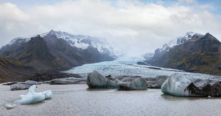
On Iceland’s South Coast, glacier melting is visible in retreating ice fronts, exposed valleys, and expanding glacier lagoons. These changes show how the ice has reshaped the surrounding landscape over time.
The South Coast is one of Iceland’s most popular travel routes, extending east from Reykjavik toward major glacier destinations. Along the route, Solheimajokull, Skaftafell Nature Reserve, and Jokulsarlon Glacier Lagoon give many visitors their first close view of Iceland’s glacial landscapes.
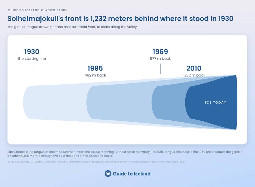
Solheimajokull provides one of the clearest examples of glacier retreat along the route. According to Katla UNESCO Global Geopark’s record of Solheimajokull’s changes, this outlet of Myrdalsjokull retreated 977 meters between 1930 and 1969.
The glacier then advanced 495 meters during a cooler period that lasted until 1995 before beginning to retreat again. By 2010, its front was about one kilometer farther up the valley than it had been in 1930. A glacier lagoon began forming in front of it in 2011.
Local students also help document these changes. Hvolsskoli students conduct annual GPS measurements of Solheimajokull, while Katla UNESCO Global Geopark has supported the project by helping them capture aerial images with a drone.
Glacier retreat is also visible farther east at Skeidararjokull. According to the 2021 overview of glacier changes in Iceland, the glacier retreated about 400 meters along the eastern side of its front in 2021.
This was the largest retreat among the glacier fronts monitored by Icelandic Glaciological Society volunteers that year. It occurred where a section of dead ice separated from the active glacier front.
The same pattern is visible near Hofn, where Hoffellsjokull has also lost a substantial part of its area. A study of glacier changes in Southeast Vatnajokull from about 1890 to 2010 found that it shrank from approximately 234.5 to 207.5 square kilometers. That represents a loss of 27 square kilometers, or about 12% of its area.
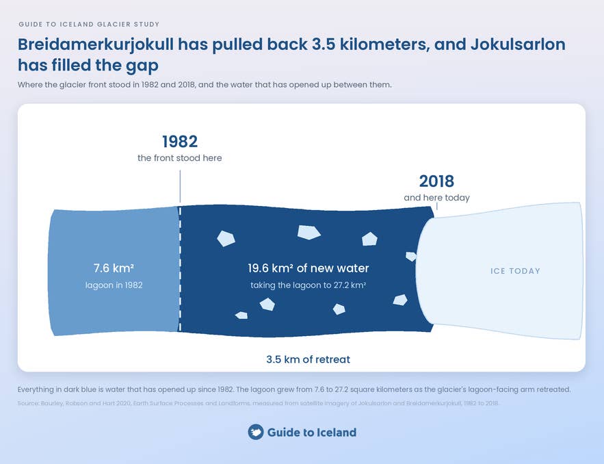
Another well-documented example is found at Jokulsarlon. A long-term study of Jokulsarlon and Breidamerkurjokull found that the part of the glacier’s eastern arm facing the lagoon retreated about 3.5 kilometers between 1982 and 2018. During the same period, Jokulsarlon grew from 7.6 to 27.2 square kilometers.
Visitors can explore the lagoon on Jokulsarlon boat tours. These trips offer views of the floating ice and the glacier front that feeds the lagoon.
Together, these records show that glacier retreat is taking place across Iceland’s South Coast. The amount of retreat differs between locations, but the effects are visible in both remote landscapes and popular visitor destinations.
Will the Glaciers in Iceland Disappear?
Iceland’s three largest ice caps are not expected to disappear completely by 2100. However, all three could lose a large amount of ice. The 129-year study estimates that Langjokull could lose about 80% of its ice by 2100. Hofsjokull could lose around 60%.
Vatnajokull is expected to lose a smaller share because it is larger and its ice is thicker. Even so, it could lose between 20% and 30% of its ice by the end of the century.
The Melting Glaciers project’s outlook for Iceland’s ice cover estimates that the country’s glaciers could lose about half their volume by 2100. After 200 years, only small ice caps may remain on the highest mountains.
Glacier hiking, snowmobiling, and ice cave tours are still available today. However, the places where these activities take place may change as the glaciers shrink. People returning to Iceland after several decades may find smaller glaciers and have to travel farther to reach the ice.
Is There Any Good News About Iceland's Glaciers?
The latest figures offer little good news about Iceland’s glaciers. The Icelandic Met Office’s 2024/25 report shows that they lost more than 15 billion tonnes of ice and were shrinking as quickly as they did between 1995 and 2011.
Past gains show that the rate of change can vary with the climate. Within Katla UNESCO Global Geopark, Solheimajokull advanced 495 meters and became about 100 meters thicker during the cooler period from 1969 to 1995.
Positive years have also occurred during the longer period of decline. In 2015, the Icelandic Met Office reported that Hofsjokull gained ice for the first time in 20 years. Heavy winter snowfall added more ice, while the cool summer reduced melting.
These gains were temporary and did not reverse the long-term decline. However, they show how strongly glaciers respond to temperature, snowfall, and the amount of winter precipitation that falls as snow instead of rain.
Iceland also continues to monitor its glaciers closely. During the 2025 Vatnajokull research and monitoring expedition, researchers maintained weather, earthquake, and GPS stations. They also measured changes in the glacier’s mass and edges, mapped the land beneath the ice, and monitored volcanoes and glacier lagoons.
Vatnajokull is protected within Vatnajokull National Park, which became a UNESCO World Heritage Site in 2019. This protection cannot stop melting caused by climate change, but it supports research, visitor education, and conservation of the wider volcanic and glacial landscape.
Can You Still Visit the Glaciers in Iceland?
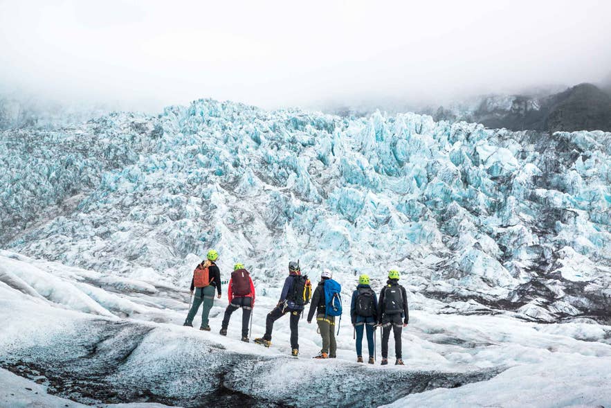
Yes, Iceland’s glaciers remain open to visitors, but access depends on the activity, season, weather, and ice conditions. Guided routes may change as glacier surfaces move, new crevasses form, and older access points retreat farther up the valleys.
For a first glacier experience, glacier hiking tours operate throughout the year at Solheimajokull and in Skaftafell when conditions allow. Travelers can join a beginner-friendly guided hike from Skaftafell, while ice climbing tours add steeper sections for those seeking a greater challenge.
Snowmobiling in Iceland offers another way to travel across the ice. Tours commonly operate on Langjokull and Myrdalsjokull, including a snowmobiling experience combined with the Golden Circle.
Natural blue ice caves are more seasonal because their structure changes as the ice melts and moves. Several winter packages and tours visit caves in Vatnajokull’s outlets, including the Crystal Ice Cave, but the cave visited and exact route depend on current conditions.
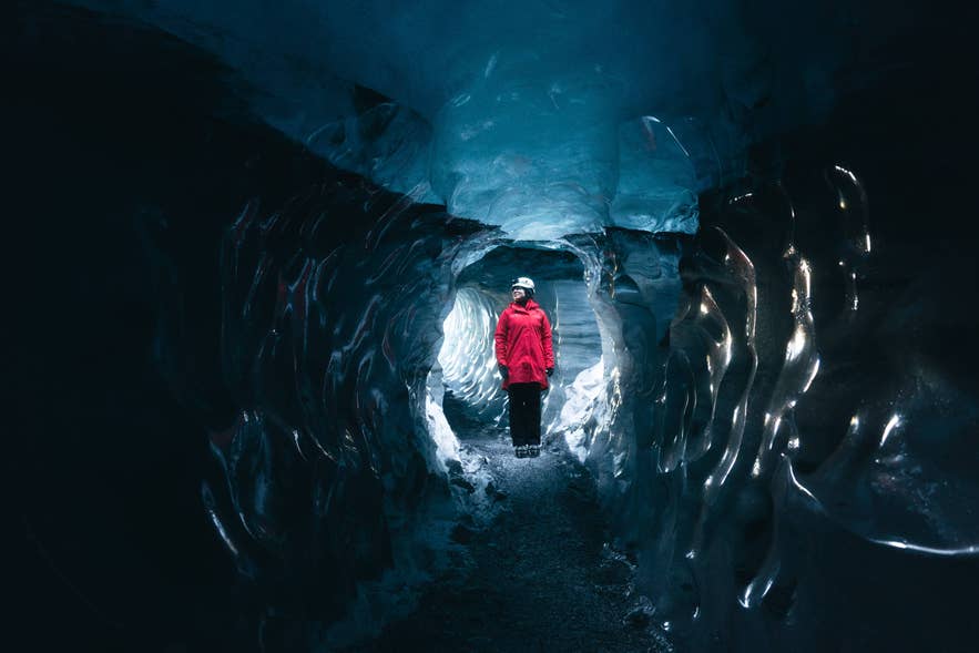
Outside the main blue ice cave season, the Katla ice cave tour beneath Myrdalsjokull operates throughout the year when conditions allow. Langjokull’s man-made tunnel can also be visited year-round on an Into the Glacier tour from Reykjavik.
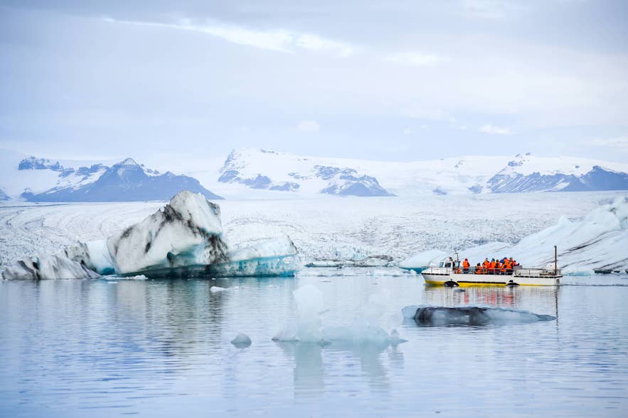
Vatnajokull can also be experienced from the water at Jokulsarlon Glacier Lagoon. Seasonal options include an amphibian boat tour, a smaller Zodiac boat tour, and kayaking among the icebergs.
After drifting out of the lagoon and into the sea, some icebergs wash onto nearby Diamond Beach. Visitors can see pieces of glacier ice scattered across its black sand.
Regardless of the activity, entering a glacier requires the necessary experience and equipment. SafeTravel’s glacier safety guidance recommends hiring a certified glacier guide because ice conditions can change, weather may be severe, and crevasses can be difficult to see.
Explore More Iceland Data Studies
This analysis is part of Guide to Iceland’s original research series. For more data-driven insights into winter travel, explore our findings on the safest month for ice cave tours, the best time to visit ice caves, the best month to see the northern lights, and the best places to see the northern lights.
For broader trip-planning ideas, see the top experiences in Iceland recommended by tourism professionals.

Guide to Iceland Editorials is the shared byline for our content team. We use it on pieces several people worked on together, where no single writer owns the article, and on anything rewritten often enough that a personal byline would be misleading.
Everything published under it is researched and reviewed by people who live and work in Iceland. If you spot something out of date or want to suggest a correction, message us and it reaches the whole team.