Guide to Iceland reviewed Iceland’s known eruption history from the settlement period to September 2026. Drawing on scientific research and official records, the analysis shows how often eruptions occur and places recent activity in a longer historical context.
Over the long term, Iceland has experienced about 20 to 25 eruptions per century, or roughly one every four to five years. However, eruptions do not follow a regular schedule. Several can occur close together, followed by a much quieter period.
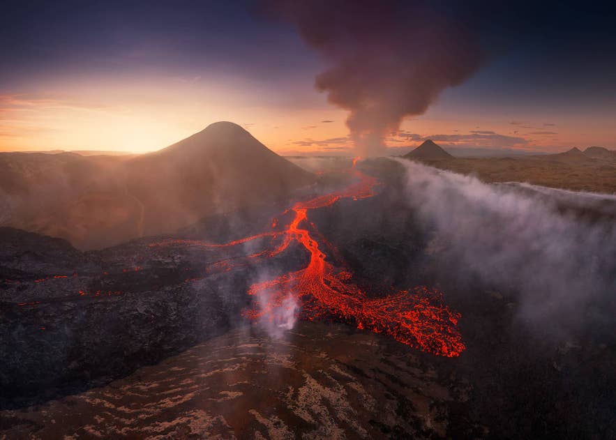
Volcanic activity in Iceland also varies widely in form and impact. Some eruptions create lava fields that later become accessible, while others produce ash, gas, earthquakes, or floods caused by melting glacier ice. The most recent eruption occurred at the Sundhnukur Crater Row from July to August 2025.
The sections below explore Iceland’s most active volcanic systems, the hazards caused by past eruptions, and how travelers can experience these landscapes on volcano tours and lava cave tours.
Cite This Study
The charts and data in this study are free to use under CC BY 4.0. Credit Guide to Iceland and link to this page. Every chart has an Embed button underneath it with ready-to-paste code.
Key Findings
-
Eruption frequency: Iceland experiences about 20 to 25 eruptions per century, equal to roughly one eruption every four to five years. This is a long-term average, not a regular schedule.
-
Volcanic systems: Iceland has 32 volcanic systems. A system may include a central volcano, groups of fissures, or both.
-
Most active system: Grimsvotn has erupted about 70 times during the past 1,100 years, more often than any other volcanic system in Iceland.
-
Recent activity: The Reykjanes Peninsula experienced 12 separate eruptions between March 2021 and August 2025.
-
Main hazards: Icelandic eruptions can produce lava, ash, volcanic gases, earthquakes, landslides, and floods caused by melting glacier ice.
-
Future eruptions: Scientists cannot predict the exact date of the next eruption. As of September 2026, magma was still accumulating beneath Svartsengi on the Reykjanes Peninsula.
How Was This Review of Iceland’s Volcanic Activity Conducted?
Guide to Iceland used peer-reviewed research and records published by Iceland’s scientific authorities. The review covers Iceland’s known eruption history from the settlement period to September 2026.
The historical overview is based mainly on a peer-reviewed study of Iceland’s volcanic history. Its researchers combined geological mapping and eruption dating with written accounts preserved in historical records. The study also explains how gaps in early documentation affect the record.
The findings were compared with the Catalogue of Icelandic Volcanoes and information from the Icelandic Met Office. The catalogue was used as the main reference for Iceland’s volcanic systems. Met Office records provided eruption histories, monitoring information, and updates on recent activity.
Peer-reviewed studies were used when more detail was needed on eruption frequency, eruptions beneath glaciers, volcanic hazards, and historical effects. Reports from Icelandic public authorities were used for evacuations, safety measures, access restrictions, and current conditions.
Figures are presented according to the definitions used by each source. Some records count a period of repeated activity as one eruptive episode, while others count each eruption separately. Recent Reykjanes volcanic eruptions were treated as separate when the Met Office identified them that way.
How Often Do Volcanoes Erupt in Iceland?
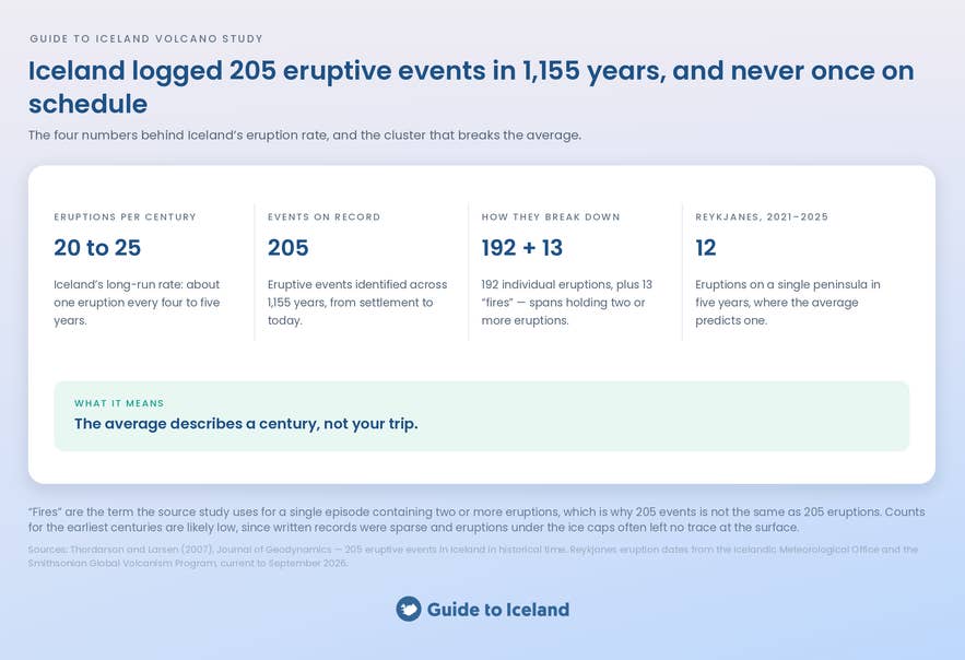
Iceland experiences about 20 to 25 eruptions per century, equal to roughly one eruption every four to five years. This estimate comes from a peer-reviewed study of Iceland’s volcanic history by researchers from the University of Iceland.
The study identified 205 eruptive events. It classified 192 as individual eruptions and 13 as fires, or longer periods containing two or more eruptions. The number of recorded events increased as historical documentation became more complete, so earlier centuries may be underrepresented.
However, some early eruptions may never have been recorded. A study of eruptions beneath Iceland’s glaciers found that some events never broke through the ice, which made them difficult to detect before modern monitoring.
Eruptions also occur at an uneven pace, with several happening close together followed by long quiet periods. The long-term average should therefore not be read as a regular schedule.
Recent activity on the Reykjanes Peninsula shows how eruptions can occur in clusters. Three eruptions occurred around Fagradalsfjall between 2021 and 2023, followed by nine eruptions along the Sundhnukur Crater Row. In total, the peninsula experienced 12 separate eruptions by August 2025.
How Many Volcanoes Are in Iceland?
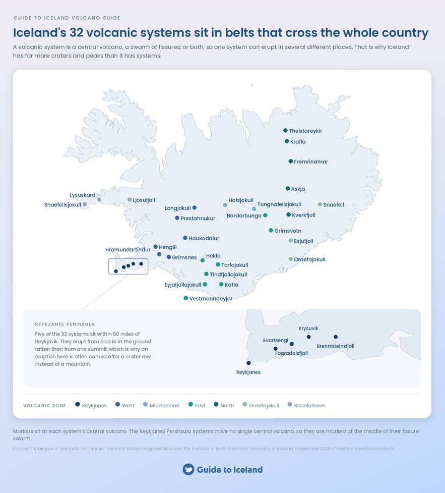
Iceland has 32 volcanic systems, based on the current list in the Catalogue of Icelandic Volcanoes. This is the clearest answer based on how Icelandic scientists organize the country’s volcanic activity.
This does not mean Iceland has only 32 individual volcanic mountains or craters. The Icelandic Met Office’s explanation of volcanic systems states that a system may include a central volcano, a group of fissures, or both. One system can therefore produce eruptions in several different places.
These systems also vary greatly in size and appearance. Some are dominated by a recognizable mountain, such as Hekla in South Iceland. Others are partly hidden beneath glaciers. The Bardarbunga Volcanic System, for example, stretches for about 118 miles (190 kilometers) and is largely covered by the Vatnajokull Ice Cap.
On the Reykjanes Peninsula, eruptions often open along cracks in the ground rather than from the summit of a single mountain. This is why an eruption may be named after a crater row or nearby area, even though it belongs to a much larger volcanic system.
Which Volcano in Iceland Erupts Most Often?
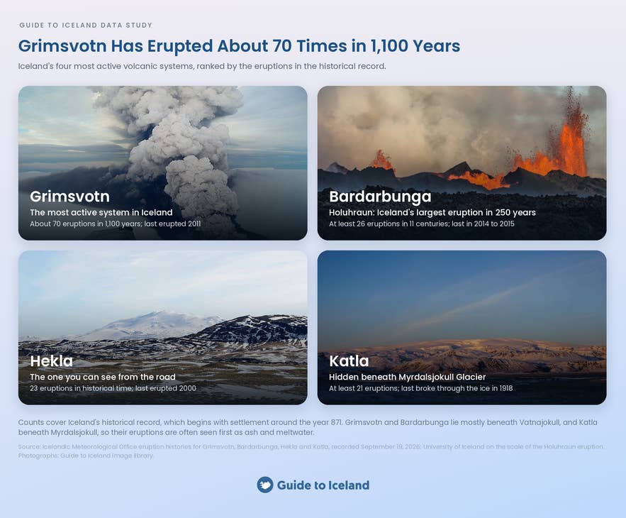
According to eruption histories published by the Icelandic Met Office, four volcanic systems stand out as Iceland’s most active. Among them, Grimsvotn Volcanic System has erupted most often, with about 70 eruptions during the past 1,100 years.
Most of the system lies beneath the Vatnajokull. Its eruptions have not occurred at a steady pace, but the most recent eruption occurred in 2011. Active periods have alternated with quieter periods lasting several decades.
Three other systems stand out in Iceland’s historical record. Bardarbunga has erupted at least 26 times during the past 11 centuries. Hekla has 23 recorded eruptions, while Katla has erupted at least 21 times in 1,100 years.
Bardarbunga is also largely hidden beneath Vatnajokull. Its most recent eruption occurred at Holuhraun between 2014 and 2015. The University of Iceland describes the Holuhraun event as Iceland’s largest eruption in 250 years.
Hekla presents a very different landscape. Its mountain rises above South Iceland and is visible across much of the surrounding region. Most Hekla tours focus on the surrounding Highlands, where routes cross lava fields and black-sand plains or stop at viewpoints overlooking the volcano.
Katla is hidden beneath Myrdalsjokull Glacier, just north of Vik. It last erupted through the ice in 1918. You cannot visit the volcano itself, but Katla ice cave excursions and glacier tours explore parts of Myrdalsjokull above the volcanic system. The surrounding area also forms part of the Katla UNESCO Global Geopark.
When Was the Last Volcanic Eruption in Iceland?
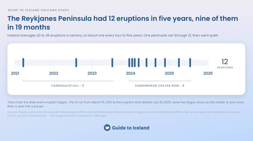
Iceland’s most recent eruption began at the Sundhnukur Crater Row on July 16, 2025. The Icelandic Met Office confirmed that the eruption ended on August 5, 2025. It occurred near the town of Grindavik and the Blue Lagoon, one of Iceland’s top geothermal spas.
The Met Office records three eruptions in the Fagradalsfjall area between 2021 and 2023. It later identified the July 2025 event as the ninth eruption along the Sundhnukur Crater Row. Together, these bring the number of eruptions on the Reykjanes Peninsula since March 2021 to 12.
By September 2026, more than 400 days had passed without another eruption. This was the longest pause since the current activity began in 2021, exceeding the 323-day gap between the 2022 and 2023 Fagradalsfjall eruptions.
The long pause does not mean the activity is over. In its September 2026 update on Svartsengi, the Met Office reported that magma was still building up underground and causing the land to rise. The magma could move toward Sundhnukur again and possibly cause another eruption, but scientists cannot predict when that might happen.
Our guide to the 2023 eruption near Grindavik explains how the Sundhnukur eruption series began.
How Dangerous Are Volcanic Eruptions in Iceland?
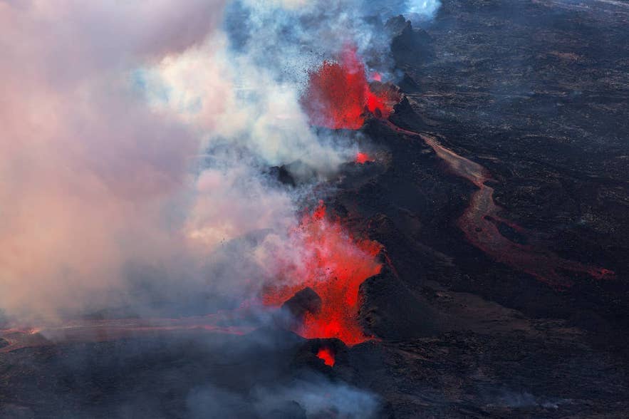
Volcanic eruptions in Iceland can be dangerous, but the risk depends on the eruption type and location. The Icelandic Met Office’s guide to volcanic hazards lists lava, ash, volcanic gases, earthquakes, landslides, and floods caused by melting glaciers among the main dangers.
History shows that lava is not the only threat. During the Laki eruption of 1783 to 1784, volcanic ash and gases damaged vegetation and poisoned livestock, contributing to severe food shortages. A 2024 study of deaths after the Laki eruption found that Iceland lost almost 20% of its population, mainly because of hunger and disease.
Monitoring and evacuation plans now help protect people. When an eruption began on Heimaey in 1973, Icelandic Civil Protection records that nearly 5,000 residents were evacuated, mostly aboard fishing boats.
Recent events near Grindavik show that homes and roads can still be damaged even when residents are moved to safety. The Met Office reported that ground movement and cracking caused widespread damage in November 2023, followed by further damage during later eruptions.
Visitors should follow official warnings and stay outside closed areas. Scientists can often detect signs of volcanic unrest, but conditions near an eruption can change quickly.
Can You See a Volcano Erupting in Iceland?
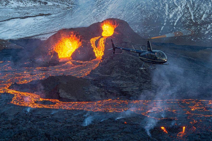
You can visit an active eruption in Iceland only when authorities open the area and consider it safe. Volcanic gases, new fissures, unstable ground, bad weather, and emergency work can all lead to closures. Most volcano tours therefore visit cooled lava fields and older volcanic sites rather than an eruption in progress.
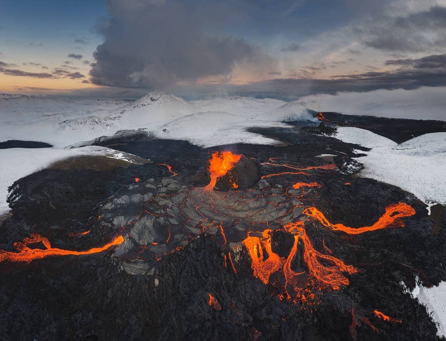
The recent activity on the Reykjanes Peninsula shows how quickly access can change. Less than an hour’s drive from Reykjavik, the 2021 Fagradalsfjall eruption was unusually easy to reach and attracted about 356,000 visits. Today, a guided Fagradalsfjall volcano hike explores cooled lava from the eruptions between 2021 and 2023.
The later Sundhnukur eruptions occurred inside a restricted area near Grindavik. Travelers cannot enter closed eruption zones, but permitted routes may offer views of the recent lava fields on a Reykjanes volcano hike and sightseeing tour. A helicopter tour over the Reykjanes volcanic fields provides another view when flying conditions allow.
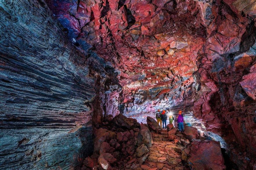
Iceland’s volcanic landscapes can also be explored underground. Beyond Katla’s ice cave tour, you can enter lava caves and other volcanic formations. The Raufarholshellir tour explores an ancient lava tunnel, while the Thrihnukagigur tour descends into an emptied magma chamber.
Near Hekla and Katla, the Lava Centre in Hvolsvollur explains Iceland’s volcanoes, eruption hazards, and monitoring work. The Icelandic Lava Show in Vik uses real molten lava to show how lava flows and cools. It also includes an educational video about Katla’s 1918 eruption.
Before entering an area affected by recent volcanic activity, check current closures and safety advice from SafeTravel Iceland. Follow marked routes, obey local restrictions, and never walk on fresh lava.
When Will the Next Volcano Erupt in Iceland?
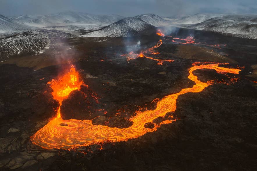
Scientists cannot give an exact date for Iceland’s next eruption. As the US Geological Survey explains, past eruptions help scientists understand long-term patterns, but they do not create a timetable for the next event.
The clearest signs of possible future activity are currently beneath Svartsengi on the Reykjanes Peninsula. As noted in the Icelandic Met Office’s September 2026 update, magma was still accumulating and causing the land to rise.
Another movement of magma toward the Sundhnukur Crater Row, possibly followed by an eruption, remained the most likely scenario.
Scientists watch for earthquakes, ground movement, gas changes, and other signs of unrest. The Icelandic Met Office’s volcano alert system brings these measurements together to show when activity is changing. Warning signs may develop gradually, but some eruptions can begin with little warning.
Explore More Iceland Data Studies
This analysis is part of Guide to Iceland’s original research series. Related studies examine the best time to visit Iceland’s ice caves and the safest month for ice cave tours.
For northern lights planning, explore the best month for aurora viewing and the Icelandic regions with the clearest skies.
For broader trip-planning insights, see the research on the best time to visit the Blue Lagoon and the top Iceland experiences recommended by tourism professionals.

Guide to Iceland Editorials is the shared byline for our content team. We use it on pieces several people worked on together, where no single writer owns the article, and on anything rewritten often enough that a personal byline would be misleading. We also publish our original data studies under this profile. Each study answers a question travelers ask about Iceland, using primary sources such as booking records, traveler reviews and public datasets, and every study is quality checked by human experts before it's published. Everything under this byline is researched and reviewed by people who live and work in Iceland. If you spot something out of date or want to suggest a correction, message us and it reaches the whole team.