National Parks in Iceland


Where are the national parks in Iceland, and what attractions do they contain? Are there specific rules as to behavior in the parks? What sets the national parks aside from the rest of the country’s beautiful nature? Read on to discover all there is to know about national parks in Iceland.
One could almost say that the whole of Iceland is a makeshift national park. After all, the landscapes are ostensibly untouched and undeveloped, often leaving wild open space from horizon line to horizon line. To pick out only a handful of attractions to officially recognize seems somewhat arbitrary, but there are good reasons behind it, which we will explore in this article.
The national parks of Iceland are located in the countryside, so book your accommodation in Iceland if you're planning to stay near these areas, or rent a car and drive to them from the capital. These national parks can also be explored on self-drive tours in Iceland, which is a great way to explore the country.
Given the Icelanders’ respect and connection to their countryside, great swathes of the landscape may as well be looked upon as nature reserves. This is regardless of the red tape, regulation, and esteem that grants Iceland’s three official national parks: Thingvellir, Vatnajokull, and Snaefellsjokull. To think this way is to adopt the attitude of a respectful visitor; national park or not, all of Iceland's nature is precious.
Migliore Tour self drive in Islanda
Tour di 7 giorni dell'aurora boreale in autonomia con auto a noleggio attraverso il Circolo d'Oro e l'Islanda meridionale
Self-drive 10 giorni con l'intera Ring Road dell'Islanda, le attrazioni migliori e Snaefellsnes
Incredibile tour self drive estivo di 1 settimana lungo la Ring Road dell'Islanda con il Circolo d’Oro
- Learn about the Most Beautiful Natural Attractions by the Ring Road of Iceland

The reasoning behind the three national parks and their official recognition lies in the respective areas’ geology, history and cultural significance, providing an incredible backdrop from where visitors can acquire a deeper insight and understanding into what makes Iceland so unique.
All three parks are managed and maintained by the Environment Agency of Iceland, Umhverfisstofnun, whose main tasks include promoting environmental protection, the sustainable use of natural resources, and offering travelers advice relating to the parks themselves.
During the summer months, Umhverfisstofnun will often take on volunteers to work on conservation projects within the park (further information can be found on the agency's website.)
Thingvellir National Park

The below poem (translated to English), ‘Mt. Skjaldbreiður’ was written by Jónas Hallgrímsson (1807-1845), a great poet and writer of the romantic tradition, to whom the Icelandic Language Day is dedicated.
Eastward, stony steeps are leaping
stalwartly from Raven Gorge;
westward, walls of rock are keeping
watch above our nation’s forge.
Grímur Goatshoe, sage and clever,
grasped the promise of this place:
Almanna Gorge, on guard forever,
girds the councils of my race.
The poem is about the volcano, Mount Skjaldbreidur (Broadshield), and the expansive, dried lava fields that—following an eruption at Skjaldbreiður over 9000 years ago—drained and formed at the base of Thingvallavatn, Iceland’s largest natural lake.
- See also: Lakes in Iceland
Warrant to Skjaldbreidur’s impressive height (1060 meters), the dried lava covered an area of over 200 square kilometers, changing the very face of the landscape and creating a deep and cragged network of caverns, fissures, and subterranean tunnels.
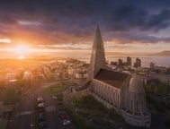
Thingvallavatn is a 32-square-mile (84km2) body of water protected under the Environment Agency of Iceland. It rests just to the side of Thingvellir, Iceland’s oldest national park, and is the only park in the country to hold UNESCO World Heritage site status, having been awarded the recognition in 2004. You can stay near the park if you book accommodation in the Golden Circle, the famous sightseeing route.

Those traveling from the capital will set their eyes on Lake Thingvallavatn before seeing the park itself. It makes for a fantastic stop for budding photographers. Despite its cold temperature, over 150 different species of plant life and 50 types of invertebrates have been discovered from the lake’s center to its shorelines.
Thingvellir National Park is located in Blaskogabyggd municipality, 30 miles (49 kilometers) away from Reykjavik, the capital of Iceland, roughly forty minutes drive by car. As previously mentioned, Thingvellir makes up one of the three stops along the highly popular Golden Circle sightseeing route, along with the dramatic Gullfoss waterfall and the geothermal valley, Haukadalur, home of the geysers.
- See also: How to Drive the Golden Circle
History & Geology
Thingvellir was designated a national park in 1928 as a means of protecting the remains of the historic site.
At that moment, it was judged to be “...a protected national shrine for all Icelanders, the perpetual property of the Icelandic nation under the preservation of parliament, never to be sold or mortgaged”.
- See also: History & Culture of Iceland
The park is the original site of the first Alþingi (“National Assembly”), formed in 930 AD. Amongst the best sources of information regarding this time is the Book of Icelanders (Íslendingabók), written by Ari "the Wise" Þorgilsson between 1122-33.

Here, the early settlers used to gather in temporary camps at the base of the exposed North American tectonic plate. The Lawspeaker (lögsögumaður), the highest official of the proceedings, would use the rock face as a makeshift sounding board, allowing all those gathered to hear, loud and clear, the dispelling of justice and the new laws of the land. Writing materials were scarce at the time, so the lawspeaker would have to remember and recite laws entirely from memory.
- See also: Elves, Vikings and Norse Gods in Iceland
It was the Law Council (Lögrétta) who stood at the center of these proceedings; comprised of the country’s many chieftains, decisions were made by a simple majority on all tribal and legal disputes, as well as queries relating to the law and everyday livelihood.
Attendees to the assembly would often travel for weeks by horseback or foot, battling the harsh Icelandic landscape to ensure their voice was heard. Upon arrival, assembly goers would set up the camps amongst the crevasses and lava lobes, sharing stories of their lives from the farthest corners of the country.

The site is particularly important for another historical event. Thingvellir is where Icelanders made the final decision to abandon their pagan ways and, instead, adopt Christianity in the year 1000 AD.
- See also: Folklore in Iceland
Today, visitors can walk and explore the exact same areas as those utilized by the early settlers, breathing life and history into the hard and cracked fissures of Thingvellir National Park.
By the time the Althingi ended at Thingvellir in the 1800s, the institution had become little more than a minor law court, its jurisdiction fully dependent on the legislation passed by the ruling Danish monarchy. It was a long way from the glory days of the Althingi, days when the concerns of Icelanders were heard in full, where their destiny could be sculpted by themselves and their fellow countrymen.
 During the 19th century, however, a drive toward Icelandic independence began to grow. Though there would be many obstacles along the way, Iceland finally managed to convene at Þingvellir on 17 June 1944, where the assembly's president, Gísli Sveinsson, declared the Icelandic constitution to be in full effect. Eventually, the Alþingi was moved to Reykjavik, where it is located today, but Icelanders have never forgotten the important steps made at Þingvellir.
- See also: The Icelandic Flag
Another reason why Thingvellir National Park is a designated UNESCO World Heritage Site lies in its astounding geological makeup. Thingvellir is one of the only places on the planet where visitors can see both the North American and Eurasian tectonic plates exposed from the Earth. The only other place where such an observation can be made is in the Great Rift Valley of Eastern Africa.
In between the plates is a graben valley—continentally speaking, a "no man’s land"—a plateau of dried lava fields, crevasses, and startling rock formations, all covered with a thick blanket of fragile Icelandic moss. This is just part of what is described by geologists and naturalists as the North Atlantic Rift system. Thingvellir sits in the Reykjaneshryggur-Langjökull rift system, (don't worry, no one will expect you to pronounce that perfectly!)

The most dramatic feature is, without a doubt, Almannagja gorge, running 7.7km and marking the eastern boundary of the North American tectonic plate. The western boundary of the Eurasian tectonic plate is called Hrafnagja, running 7 miles (11 kilometers). Both plates are seen as the visual personification of the Earth’s makeup below the surface.
To the south of Thingvellir, the plates move adjacent to one another, while at the park itself, the plates are actively breaking apart, creating an ever-increasing amount of land between them. This is an incredibly slow process, the land increasing at little under 1 millimeter a year (the plates themselves see a pull away of 7 millimeters).
That’s not to suggest that the geology is inactive; in fact, inner tension builds under the Earth’s surface throughout this period, often breaking out in sudden and potentially violent bursts of energy. The last major outburst was in 1789, causing an earthquake at Þingvellir that increased the graben valley by 1-2 meters.
Attractions
As previously stated, Thingvellir is an attraction in itself, its astounding beauty so utterly delightful that it makes up an integral part of the Golden Circle sightseeing tour. But what actually is there, aside from the natural splendor, that can preoccupy your precious holiday time at Thingvellir? Thankfully, more than you might think.
For starters, visitors to Þingvellir can visit the rumbling waterfall, Oxararfoss. The waterfall flows from the river Oxara, finally reaching its lip and tumbling down over the side of the Almannagja into a rocky pool below.
 The name of the waterfall translates to “Axe River Falls.” Some consider this an allusion to executions that took place at Þingvellir over the presiding centuries, while others claim the name derives from an axe—a symbol of land ownership at that time—that was thrust into the icy river Oxara by early settlers.
A walkway now constructed along the Almannagja provides information boards describing the area’s incredible history, even pointing out particular spots of interest, such as the “Law Rock” (Lögberg) and the Deep Drowning Pool, Drekkingarhylur, a part of the 17th-century Icelandic judicial system. Women found guilty of infanticide or incest were drowned there, adding an eeriness to Almannagja that can hardly be described.
- See also: 40 Best Locations in Iceland
Þingvellir is also home to one of Iceland’s most famous attractions, the sublime glacial spring Silfra fissure. Routinely voted as one of the best scuba diving and snorkeling sites worldwide, Silfra Fissure is famed for its crystal clear visibility. It can be explored on diving tours accompanied by a professional diver.
The reasons for this are twofold. First, the water in Silfra originates from the glacier Langjokull, taking between 50-100 years to travel through a series of underground networks and filters. This means that Silfra fissure is filled with filtered glacial water, ensuring its drinkability and freshness.

Second, Silfra is a spring, meaning its water is in constant flow on its way to Thingvallavatn. This ensures that should any sediment be kicked up by divers or snorkellers in front, the visibility will quickly be restored. This constant flow is also the primary reason why Silfra fissure does not freeze in the wintertime, keeping it readily available as an attraction throughout the year.
- See also: Scuba Diving and Snorkelling in Iceland
Silfra fissure’s scenery is, in a single word, epic. Split into four distinct areas, scuba divers and snorkellers will first enter ‘the toilet,’ rudely named but fitting, especially considering this section sees the glacial water open up into the fissure.
Swimming through this narrow, cragged gorge, the group will come into Silfra Hall, the fissure’s widest point. Silfra Hall provides an excellent perspective on just how dramatic this feature is. Moving further along with the light current, the fissure will become deeper, its depths turning to a dark and mysterious blue. This area is called, aptly, Silfra Cathedral.

Photo from Guided 1 Hour Drysuit Diving Tour in Silfra with Hot Drinks with Transfer from Reykjavik
Turning away from the lake, snorkellers and divers will move into what guides describe as the “real Blue Lagoon.” This relatively shallow area allows guests to explore the many cracks and fissures at their own pace before exiting the water. Overall, a single run through Silfra will last from half an hour to 45 minutes. Don’t expect to see fish as the water tends to be too cold in the fissure, though baby fish will use the rock’s hidden crannies as a nighttime nursery.
Camping & Conduct
There are two permitted areas for one to camp at Thingvellir, both of which are open from the 1st of June to the 30th of September. However, from the 1st of October to the final day of May, the campground beside the Visitor’s Centre remains open.

The first campground at Þingvellir is called Leirar and is split into four separate grounds: Nyrdri-Leirar, Sydri-Leirar, Fagrabrekka, and Hvannabrekka. Leirar is within easy walking distance (no more than 5 minutes) from the Visitors Centre. The second campground, Vatnskot, is found at an abandoned farmstead beside Lake Thingvallavatn.
Whichever campsite you choose, permits for both camping and angling should be purchased at the Visitor’s Centre upon first arrival at Thingvellir. Thankfully, no reservation is needed to camp at Thingvellir, meaning you can simply roll up and start setting up! With that being said, reserving your place at the campground is possible and is recommended for those anxious about securing their place.

- See also: Top 10 Travel Tips in Iceland
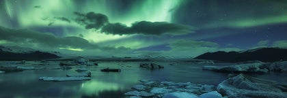
Vatnajokull National Park
This is by far the largest national park in Iceland, containing the whole of Vatnajokull glacier, the largest glacier in Europe.
The park’s namesake, the mighty glacier Vatnajokull, covers an astounding 13% of Iceland’s total landmass. When the park was first founded in 2008, the total area covered was 12,000 square kilometers, integrating two former national parks, Skaftafell (est. 1967) to the south and Jokulsargljufur (est. 1973), in the north.
Vatnajokull National Park was founded to conserve the area’s history, ecology, cultural heritage, and dazzling landscape. If you want to stay near this national park, you can book accommodation in South Iceland close to the glacier.
- See also: Glaciers in Iceland
With the recent additions of such regions as Krepputunga, Lakagigar, and Jokulsarlon, the park now covers 14,000 square kilometers (approx 14% of Iceland), making it the second largest national park in Europe, after Yugyd Va in Russia.
Still, nowhere displays the eternal struggle between fire and ice so beautifully as Vatnajokull; beneath that, frozen exterior bubbles the powerful, molten heat of our planet.
History & Geology
 It is estimated that the ice cap, Vatnajokull, began forming 2500 years ago. Due to its high elevation and mild, pleasant climate, the region was highly fertile, Skaftafell in particular, used for sheep grazing and as a congregation point for þings (“assemblies.”) The farmers’ livelihood was supplemented by trips to the coastline, where they would hunt for seals, collect bird eggs and scavenge supplies from stranded ships.
- See also: Witchcraft and Sorcery in Iceland
The inhabitants of the Skaftafell region enjoyed a fruitful operation—that is, until the devastating eruption of Oraefajokull in 1362. The effects were immediate, with enormous jökulhlaups (literally, “glacial run”) sweeping through the area, overwhelming everything in its path and destroying the community. Ever since, the area has been known as Oraefi, the "wasteland."
Still, even that couldn’t put the entrepreneurial Icelanders off for long, and soon, new farms and settlements began to crop up across the region. No thanks to a cooling climate, these farmsteads were less successful than their predecessors, and Skaftafell would never again reach the political heights it had enjoyed in the 14th century.

Subsequent jökulhlaups—originating, this time, from the 1783 Grimsvotn eruptions—would mean a further nail in the coffin for successful, long-term agriculture in the region. Even so, it was not until 1988 that farming at Skaftafell was permanently discontinued, and now it serves as the name of the preservation area.
- See also: Things That Can Kill You in Iceland
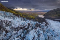
Outside of the Arctic, Vatnajokull is Europe’s largest glacier, covering 3127 square miles (8,100 km2) with ice averaging out at 2000-3000 feet (600-900 meters) thick. The ice cap is, in fact, so large that beneath it, plateaus, valleys, mountains, and volcanoes are hiding, including Grimsvotn and Bardarbunga. On the southern periphery is Iceland’s highest peak, Hvannadalshnukur, summiting at 1.31 miles (2109 meters).
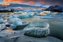
Vatnajokull has approximately 30 outlet glaciers stemming from it, a testament to the ice cap’s incredible overall size and influence. The most famous of these is, arguably, Breidamerkurjokull, which ends at the small glacial lagoon, Jokulsarlon. Given Jokulsarlon’s immense popularity amongst visitors and locals alike, Breidamerkurjokull is often the best visual stimulus for understanding just how expansive, varied, and dramatic Vatnajokull is in its entirety.
Attractions

Every year, as the ice melts, new ice caves are formed, which visitors can explore as a part of an ice-caving tour. At the beginning of each winter season, caving and ice-climbing tour operators embark to discover incredible new, frozen caverns hidden away in Vatnajokull’s farthest corners. The natural ice caves are usually only accessible between November through to the end of March yearly, although some operators start tours in mid-October.
By partaking in an ice cave tour, guests have the opportunity to experience the glittering inside depths of Vatnajökull, seeing for themselves the intricate and natural ice sculptures and the dark shades of blue locked into the ice itself.
- See also: The Ultimate Guide to Ice Caves in Iceland.
- Check out this 7 Day Northern Lights Self Drive Tour | Destination Ice Cave
Aside from the stunning panoramas and potential for cave exploration, Vatnajokull National Park contains some of the country’s most exciting and memorable attractions, including the country's largest glacier, tallest mountaintop, and highest waterfall! Canyons, lagoons, mountainscapes, and fertile valleys all lie in wait for those ready to discover the park’s many memorable highlights.
Out of the many fantastical names and locations you’ve heard spoken of during your time in Iceland, chances are that Vatnajokull National Park contains at least some of them: Jokulsargljufur, Skaftafell Nature Reserve, Odadahraun, Snaefell Wilderness Area, Jokulsarlon glacial lagoon, Lakagigar (Laki craters) and Nyidalur.
Surprisingly, Iceland's tallest waterfall, Morsarfoss, is one of the newest members of the attractions in the park, as it only appeared in 2007, when the surrounding glacier, Morsarjokull, had melted enough to reveal it. It is, however, extremely hard to reach it.
In this regard, Vatnajokull National Park is something of an all-natural theme park, offering entertainment, bewilderment, awe, thrills, and spills for the entire traveling party. The park is split into four administrative sections—north, south, east, and west—each managed locally. The northern territories include Askja caldera, the north-western section of Vatnajokull, Jokulsargljufur canyon, and portions of Jokulsa a Fjollum. Guests will also find a campsite and visitor’s center in the horse-shaped canyon of Asbyrgi. Another campsite can be found in Vesturdalur.
In the park’s western section, visitors can stumble upon the southwest corner of Vatnajokull, Langisjor, the Lakagigar craters, and an information center run by the park at the town of Kirkjubaejarklaustur. The southern section extends across Vatnajokull’s southeast, all the way from Lomagnupur mountain to Lonsoraefi, whilst the eastern section includes northeast Vatnajokull, parts of the Snaefellsoraefi hiking area and the dramatic Kverkfjoll mountains.

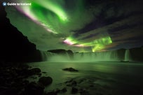
From all of the aforementioned attractions, Jokulsarlon is perhaps the best-regarded natural attraction at Vatnajokull, a glittering lagoon decorated with aquamarine icebergs, breaking away from their parent glacier and idly floating out towards the Atlantic Ocean. You can visit this natural wonder on a wide variety of Jokulsarlon tours.
- See also: Glacier Lagoons in Iceland
Where the icebergs actually meet the ocean is known as Diamond Beach, for self-explanatory reasons. Amongst these icebergs, in the lagoon and by the coastline, lives a playful seal colony, only adding to the quintessential beauty of the lagoon.
Throughout the last half-century, Vatnajokull, with its sweeping slopes and frozen terrain, has been utilized as a shooting location for numerous cinematic and television productions. The glacier was used as a setting in the opening scenes of the 1984 James Bond film, A View to a Kill. More recently, Vatnajokull, as well as Thingvellir National Park, served as a shooting location for HBO’s popular fantasy series, Game of Thrones.
- See also: Movie Locations in Iceland
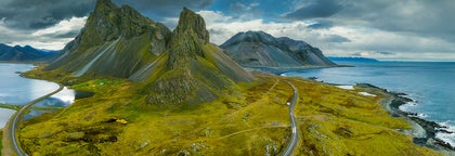
Snaefellsjokull National Park

Snaefellsjokull National Park was established in June 2001. As with the other national parks, it was founded due to the need to protect the region’s heritage, incredible natural diversity, and fascinating cultural sites.
Covering just 170 square kilometers of land, Snaefellsjokull National Park is wonderfully varied, with rocky coves, lava plateaus, towering bird cliffs, and sloping glaciers all contribute to the region’s reputation as “Iceland in miniature,” showcasing the best natural features that Iceland can offer. If you want to explore this region, make sure to book a hotel on the Snaefellsnes peninsula for easy access.
Reaching Snaefellsjokull National Park from Reykjavik requires a 120-mile (190-kilometer) journey (approximately 2 hours and 40 minutes drive) across some truly mesmerizing terrain. As one approaches the park, the region’s main focal point, Snaefellsjokull volcano, is an omnipresent sight, growing larger and larger on the horizon line until it suddenly dominates the landscape. This powerful and captivating feature is a must for all those looking to maximize their sightseeing opportunities in Iceland. There are many Snaefellsnes tours where you can explore the many wonders of this region.
History & Geology

Photo by Jón Óskar Hauksson
Over 700,000 years old, Snaefellsjokull is a domineering, ice-capped stratovolcano resting on the far western point of the Snaefellsnes peninsula. Interestingly enough, the volcano is actually named Snaefell, but is called "Snaefellsjokull" colloquially in order to distinguish it from two other mountains called Snaefell.
Snaefellsjokull is, in fact, so large that on a clear day, onlookers can see it 75 miles (120 kilometers) away, jutting out from the horizon across Faxafloi bay. Seeing the volcano from Reykjavik is a majestic experience in itself, but it makes for a petty experience in comparison to seeing it up close—only then will visitors grasp the stratovolcano’s sheer scale and its enormous impact on the surrounding landscape.
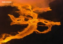
Archaeological sites such as Forni-Saxholl farm, Berutoftir and Irskubudir all imply that the peninsula was inhabited as far as 1100 years ago. This was sometime after the volcano’s last eruption, which took place sometime between 50-350 AD. During this eruption, the landscape was steadily molded by lava flows, creating numerous cave networks and craters, many of which can be explored today by guests.

Following this volcanically active period, the 12th and 13th centuries saw the region prosper through fishing, with steady population growth around the glacier itself. Fishing was undertaken wherever there was ample access to the sea. Dritvik is perhaps the best example of one such fishing settlement. Historically, the largest commercial harbor in the region, Dritvik boasted up to 60 fishing vessels and 400 inhabitants. Fishing would decline in the 19th century due almost entirely to a change in fishing practices across Iceland.
To the far north of Dritvik, a church was built at Ingjaldsholl hill that dates back to the 1200s. Today, a modern church sits in its place, but it is still a lasting reminder of this region’s fascinating history.
Snaefellsjokull has long been a subject of fascination for artists the world over, inspiring countless paintings, poems, and pieces of music. The region is the main setting for the first part of Bárðar saga Snæfellsáss, a late and legendary saga of the Icelanders.

Photo by Regína Hrönn
Dating back to the early 14th century, Bárðar saga Snæfellsáss is split into two distinct sections; the first deals with Bárður Snæfellsáss, a human/troll/giant hybrid who, after arriving on the peninsula, settled down on a farmstead with his wife and children.
After a series of unfortunate events, including a vengeful couple of murders, Bárður exiled himself to the ice cap, where he was soon looked upon by the surrounding population as a “guardian spirit.”
Bárður was said to patrol the region "in a grey cowl with a walrus-hide rope around him, and a cleft staff in his hand with a long and thick gaff". His saga alone is not the only time that Snæfellsnes makes an appearance in these medieval manuscripts; the region is also used as the setting of a 13th-century scripture, Laxdæla saga, written by an unknown author.
Snaefellsjokull was made most famous, perhaps, by the French novelist Jules Verne, who used the volcano as the entry point to a strange and fascinating subterranean world in his sci-fi classic “Journey to the Centre of the Earth” from 1864.

In the novel, Professor Lidenbrock and his nephew, Axel, travel to Snaefellsjokull in the belief that they can access volcanic tubes to the planet’s core. Descending into the caldera, the pair witness a number of strange phenomena, including prehistoric animals, giant mushrooms, and underground oceans. After a series of misadventures, the team finally reaches ‘the other side,’ reappearing from the Stromboli volcano in Italy to be hailed as scientific heroes.
There is no doing justice to the artistic influence that Snaefellsjokull has had over the centuries; the ice-cap features prominently in Under the Glacier (1968), a novel penned by Halldór Laxness, as well as the 1960s Blind Birds trilogy, written by Czech author, Ludvík Souček.
Attractions

Aside from activities centered around Snaefellsjokull, visitors can choose to explore Songhellir (“Cave of Song”), a cavern that takes its name for the distinctive echoes that can be made inside. Although guests will be able to read a number of names that have been carved throughout history on the interior walls, including those of Eggert Ólafsson and Bjarni Pálsson, who traveled the country during the 18th century, carving your name (or words or pictures) anywhere into Iceland's nature is not encouraged.
Another cave worthy of a visit is Vatnshellir; here, guests will descend a spiral staircase into a colorful chamber formed by ancient magma flows. 8000 years old and counting, this 200-meter-long lava tube originated from eruptions at the nearby Purkholar crater family. In order to preserve this interesting and geologically important cave, Vatnshellir was closed off to public access by the national park a few years ago. It can now only be explored with a licensed tour guide.
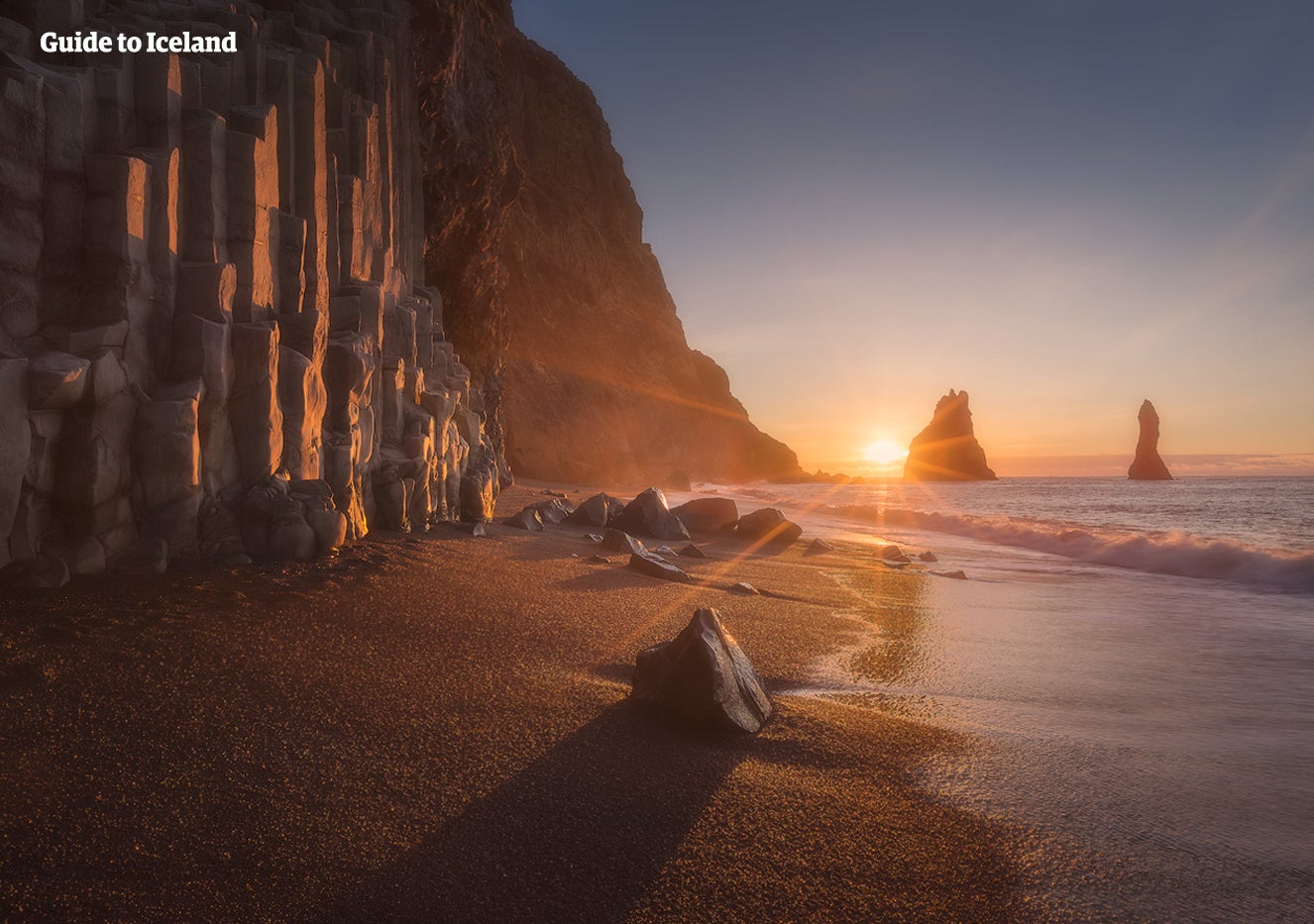
Caves, caverns, craters, and canyons dot the full range of Snæfellsnes Peninsula. One of the most popular stop-offs is Raudfeldsgja (Red-cloak rift), a 40-meter-deep rift into a mountainside. The first part of this rift is fairly easy to navigate, though the terrain becomes trickier and more slippery, the deeper one goes. Those who venture to the rift’s end will get soaked but be rewarded with a beautiful hidden waterfall.
Other attractions include the small hamlets of Arnarstapi and Hellnar, which sit right by the edge of the park, with their nearby rock formations and cliffs along the coast. The views from these small settlements can be serene on calm days or spectacular with the force of the surf breaking on the rocks.
The most beautiful beach within Snaefellsjokull National Park, however, is perhaps Djupalonssandur, with its pitch-black sands and pebbles, surrounded by lush green moss-covered lava and containing the ruins of an old British trawler.

Nearby to the town of Grundarfjordur, outside of the park itself, one can find the most photographed mountain in Iceland, Kirkjufell. Fans of HBO’s Games of Thrones’ will recognise this feature instantly as “the mountain like an arrowhead”, from the Hound’s vision in Season 7.
Given its reputation for making a visually stunning subject, Kirkjufell is made all the brighter by its adjacent waterfall, Kirkjufellsfoss, which makes for an excellent foreground. Photographers will find this subject full of opportunities as the mountain changes color with the passing seasons, thus creating a number of photographic possibilities.
On their way towards the park, nature lovers will also jump at the chance to visit Ytri-Tunga, otherwise known as “seal beach” (Ytri-Tunga is, in fact, the name of a nearby farmstead). As its name suggests, this area is reliably inhabited by a playful seal colony during June, July, and August.
For those particularly interested in wildlife, it should be noted that Grundarfjordur town is one of the best locations in the world where to spot killer whales, the town’s harbor offering numerous whale-watching tours.
Did you enjoy our article about National Parks in Iceland? Which was your favorite National Park, and what attractions did you visit? Make sure to leave your comments and queries in the comments box below.


Altri articoli rilevanti

Visitare l'Islanda a marzo | La guida completa
Scopri tutto ciò che devi sapere sull'Islanda a marzo. Scopri le attività disponibili, come la speleologia del ghiaccio e vedere l'aurora boreale. Leggi alcuni consigli degli esperti su cosa mettere...Leggi altroLe grotte in Islanda
Quale tipo di grotte si trovano in Islanda e dove è possibile effettuare escursioni speleologiche? Leggi qui per trovare tour speleologici o clicca qui per un tour delle grotte di ghiaccio dalla...Leggi altroL'Islanda ad aprile: cose da fare, tempo e aurore boreali
Scopri tutto quello che c'è da sapere sull'Islanda ad aprile. Che tempo fa ad aprile? C'è ancora la neve? Quali attività si possono fare ad aprile? È possibile vedere l'aurora boreale? Il mese di ap...Leggi altro


Scarica il più grande mercato di viaggi in Islanda sul telefono per gestire l'intero viaggio da un unico posto
Scansiona questo codice QR con la fotocamera del telefono e premi il link che compare per avere sempre in tasca il più grande mercato di viaggi in Islanda. Inserisci il numero di telefono o l'indirizzo e-mail per ricevere un SMS o un'e-mail con il link per il download.