Hiking in Iceland: A Complete Guide to the Best Hikes and Trails

- Preparing for a Hike in Iceland
- Difficulty of the Hike
- What to Pack for a Hike in Iceland
- The Best Hiking Trails in Iceland
- The Best Hikes in the Icelandic Highlands
- Landmannalaugar hiking trail
- Three major hiking routes in Landmannalaugar:
- Laugavegur Hiking Trail
- Fimmvorduhals Hiking Trail
- The Best Hikes in the Westfjords of Iceland
- Hiking the Hornstrandir Nature Reserve
- The Best Hikes in the Eastfjords of Iceland
- Viknaslodir Hiking Trails in the Eastfjords
- Borgarfjordur Eystri to Seydisfjordur Hike
- The Best Hikes in South Iceland
- Svartifoss Waterfall Hike in Vatnajokull National Park
- Skogafoss Waterfall Hike
- Seljalandsfoss Waterfall to Gljufrafoss Waterfalls Hike
- The Best Hikes in North Iceland
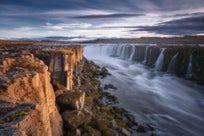
- Dettifoss Waterfall to Selfoss Waterfalls Hike
- The Best Hiking Trails Around the Golden Circle
- Gullfoss Waterfall Hike
- Oxararfoss Waterfall Hike in the Thingvellir National Park
- Hiking to Reykjadalur Hot River Valley
- The Best Hiking Trails in the Snaefellsnes Peninsula
- Arnarstapi to Hellnar Hike in the Snaefellsjokull National Park
- The Best Hiking Trails on the Reykjanes Peninsula
- Keilir Mountain Hike
- Hafnir Town to Hafnaberg Sea Cliffs Hike
- The Best Hiking Trails Close to Reykjavik
- Hiking Esjan Mountain
- Hiking to Helgafell Mountain
- Hiking to Glymur Waterfall
- Best Glacier Hikes in Iceland
- Hvannadalshnukur Hike in Vatnajokull National Park
- Svinafellsjokull Glacier Hike
- Falljokull Glacier Hike
- Solheimajokull Glacier Hike
- Additional Hiking Spots in Iceland

Iceland seems to be designed with hikers in mind. It is a wild country filled with roaring rivers, mountainous canyons, and beautiful valleys, and in every region of the island, you can find fantastic hiking trails.
You will find that there is a hiking trail suitable for everyone, from short day hikes that are ideal for beginners to more challenging trails for more experienced hikers. The variety makes hiking in Iceland so exciting that visitors often return, year after year, to tick off the next trail on their bucketlist.
Make sure to book your accommodation in Iceland near your desired hike so you will have a comfortable base from which to head out on your hiking adventures. Each trekking experience on this beautiful island is unique and different from any other.
Whether you are looking to hike with a group on guided hiking tours or explore the country at your own pace by renting a car in Iceland, this complete guide will give you all the information you need to get started on planning your hike.
- See also Camping in Iceland | All You Need to Know
- Discover all the Tips for Backpacking in Iceland
Preparing for a Hike in Iceland

Hiking in Iceland, like anywhere else in the world, requires some careful planning, preparation, and a bit of courage before you set off. A few questions you should have the answer to before heading on your journey are:
-
How long is the hike?
-
Have you informed someone of your plans and estimated return time?
-
Do you know the emergency services phone number in Iceland and how you can contact them?
These are just a few crucial questions you should consider before lacing up your hiking boots. Think through every possible scenario, even the unlikely ones, and ask yourself if you're fully prepared to handle whatever comes your way.
Difficulty of the Hike
 To determine the hike's difficulty, consider the distance of the trail of your choice, evaluate your physical fitness, and estimate how long you think the hike will take you. An easy method of doing this is to do some basic research, either online or through specific hiking trail books relating to Iceland's hikes. There are many on the market and you can find them at numerous tourist information centers across the country.
The critical information to note about the hiking trail is:
-
The expected elevation
-
The type of terrain, e.g., paved trail, dirt trail, on a lava field
-
The duration of the hike
These three elements should give you an idea of what the hike would be like to complete. However, some of the trails are nothing more than a walk. You must also consider what specific equipment to take with you on a hike, which items best suit your trek, and what you can physically carry.
It is also essential to know the emergency phone number in Iceland is 112 and that you should let the search and rescue team know about the more strenuous hiking plans in advance by filling out the form on the Safe Travel website, especially if you are going to be doing difficult hikes on your own.
What to Pack for a Hike in Iceland
 Once you have established what kind of hikes you would like to do while visiting Iceland, you will have to pack! The key things to bring are those that will help you navigate the area and keep warm and safe while on your hike.
Iceland is known for its unpredictable weather conditions and stunning natural landscapes. Whether you plan trekking across volcanic terrain, exploring glaciers, or hiking through green valleys, being well-equipped is essential for both safety and comfort.
Essential packing list for all hikes in Iceland:
-
Warm clothes: It's best to wear layers when hiking in Iceland to adjust to the weather.
-
Waterproof and windproof jacket and pants: Essential during the winter months in Iceland.
-
Sturdy hiking boots: Iceland's terrain demands good shoes.
-
Scarf, gloves, and hat: For added warmth and wind protection around your neck and face.
-
Water bottle: It's recommended to bring 0.26 gallons (one liter) for a two-hour hike. More is needed for strenuous hikes, while less is generally required during colder weather.
-
Snacks: Energy gel for more challenging hikes and granola bars for lighter hikes. If you're going on a long trek, bring more food.
Additional packing items for difficult hikes in Iceland:
-
Warm underlayer: Wool leggings, top, and socks as base layers to stay warm.
-
Backpack: Ideally, a durable, waterproof backpack with a rain cover.
-
Map and compass or GPS device: Essential for navigation, especially in remote areas.
-
First aid kit: Including bandages, blister pads, pain relievers, and any personal medications.
-
Trekking poles: These are helpful for stability on uneven terrain and during river crossings.
-
Headlamp or flashlight: with extra batteries, especially important during the long nights in winter.
These lists are not exhaustive, but they will give you an idea of the things you need to keep in mind before venturing to Iceland on your exciting hiking trip.
- Read more about the Search and Rescue Teams in Iceland
- Discover The Weather and Temperature in Iceland
- Learn about When is the Best Time to Visit Iceland
The Best Hiking Trails in Iceland
 Now that you’re fully packed, it's time to explore the best hiking trails in Iceland. With a wide variety of walks and treks in each region, deciding where to hike can be a challenge.
Some visitors attempt the ultimate adventure of hiking across Iceland from the north to the south. This demanding journey takes around 18 to 20 days to complete and is only recommended for incredibly experienced hikers and only safe to do during the summer months.
A more popular and manageable choice is shorter multi-day hikes ranging from one to six days. Among these, you will find the famous Laugavegur hiking trail and Fimmvorduhals trail, the most well-known hiking trails in Iceland, filled with stunning scenery.
Other fantastic hiking options in Iceland include those in Hornstrandir in the Westfjords, as well as trails in Viknaslodir in the Eastfjords. But, if you’re looking for something less intense, shorter half-day hikes are also an option throughout the country, with several of them close to Reykjavik city.
Read on to explore the best hiking trails in each region of Iceland.
The Best Hikes in the Icelandic Highlands
Learn about the untamed beauty of the Icelandic Highlands with this guide to the best hikes in the area. These trails offer breathtaking landscapes and panoramic views, perfect for nature lovers and thrill-seekers looking for unforgettable adventures.
Landmannalaugar hiking trail
 The Landmannalaugar highland hiking trails are widely regarded as one of the best treks in Iceland. The area's geothermal activity means Landmannalaugar Highland's rivers and streams are warm and perfect for bathing, which is the ideal way to relax after a hike.
On top of that, the incredible mountains seen during the hike have stunning tones of orange, green, purple, and red, making this region a beauty to witness. These mountain colors have long made Landmannalaugar a must-see for photographers worldwide.
It is important to note that the central highlands, where Landmannalaugar is, are only accessible in the summer months in Iceland, from late June or early July until the end of September, weather permitting.
Three major hiking routes in Landmannalaugar:
1. Laugahraun Lava Field to Brennisteinsalda Mountain Hike
 This hike takes you from the edge of the raven-black Laugahraun lava field to the breathtaking Brennisteinsalda volcano. Brennisteinsalda volcano is 0.5 miles (0.8 kilometers) tall, and its name derives from the large sulfur spots that dot the mountain's side. Due to the red of the iron, the dark blues of the volcanic ash, and the green of the moss, Brennisteinsalda volcano is considered the most colorful mountain in Iceland.
-
Distance: 4 miles (6.5 kilometers)
-
Duration: Two to three hours
-
Difficulty: Moderate
2. Mount Blahnjukur Hike

The second hike is to the 3,051-foot (940-meter) high summit of Mount Blahnjukur, or the blue peak as it translates into Icelandic. Throughout the hike, you'll be in awe at the dark blacks and blues of the surrounding lava flows and settled ash. The mountain sits beside Brennisteinsalda mountain, and on a clear day, you can look out at five different glaciers from its peak. This is one of the best hikes in Iceland for avid landscape photographers.
-
Distance: 4.1 miles (6.6 kilometers)
-
Duration: One to two hours
-
Difficulty: Moderate
3. Ljotipollur Crater Lake Hike
 Finally, hikers can trek to the Ljotipollur crater lake, which means, in Icelandic, the ugly puddle. Don't let the name put you off, as this hike demonstrates the staggering diversity of the Landmannalaugar Highland's landscape. The name is a disservice to the "puddle" itself as the lake is deep, beautiful, and filled with trout fish, surrounded by sloping red colors, strikingly contrasting the dark gravel.
-
Distance: 8.19 miles (13 kilometers)
-
Duration: Four hours
-
Difficulty: Moderate
Laugavegur Hiking Trail
 On the Laugavegurinn hiking trail, you won't find souvenir stores, bars, cafes, clothing outlets, or galleries - only spectacular scenery. This name can confuse visitors, as Reykjavik's Laugavegur shopping street carries the same name as this hike in the Highlands.
If the Laugavegur hiking trail is what you are looking for, you first need to decide which direction you want to do the hike. You can either start from Landmannalaugar or Thorsmork valley on this beautiful long hike. Most people choose to start from Landmannalaugar and hike to Thorsmork because that way, you will ascend at a lower altitude.
Traditionally, the route takes two to four days, with overnight stays at the mountain huts of Hrafntinnusker, Hvanngil, Emstrur, and Alftavatn. There are also mountain huts at the start and end of the hike in Landmannalaugar and Thorsmork. If you have not booked a hut in advance, then it's also possible to camp by the huts (but you'll need to bring your tent with you).
-
Distance: 34 miles (55 kilometers)
-
Duration: Four days
-
Difficulty: Moderate to difficult
Fimmvorduhals Hiking Trail

If the 34 miles (55 kilometers) of the Laugavegur trail isn't long enough for you, then you can extend the hike one more day by adding the incredible Fimmvorduhals hiking trail. It's a picturesque area located between the Eyjafjallajokull volcano and Myrdalsjokull glacier.
The route begins from Thorsmork and continues for 14 miles (22 kilometers) past countless waterfalls, ice sheets, and volcanic fissures to the Skogar area.
If you only plan to hike the Fimmvorduhals trail but not the Laugavegur trail, starting from Skogar and ending in Thorsmork is the more common route to take. The entire hike takes around 10-12 hours, and some people choose to do it over two days, spending one night in a mountain hut along the way.
Hikers traveling through the Fimmvorduhals trail will ascend up to 3,300 feet (1,000 meters) to navigate their way to the trail's end.
Book your mountain huts through the Iceland Tour Association and get a highland hiking bus passport for an easy ride to and from your starting and ending locations.
Or if you have a small rental car, you can leave it at Hvolsvollur town and join a day tour to Thorsmork in a super jeep because you'll need to cross some difficult, unbridged rivers to get there that are only accessible by a 4x4 rental vehicle. Once you are there, enjoy spending the day doing short hikes within Thorsmork.
-
Distance: 16 miles (25.7 kilometers)
-
Duration: One to two days
-
Difficulty: Difficult
The Best Hikes in the Westfjords of Iceland
Discover the hidden gems of Iceland’s Westfjords and learn about the best hikes in this remote and tranquil region. These trails offer stunning coastal views and rugged landscapes, perfect for those seeking solitude and unspoiled nature.
Hiking the Hornstrandir Nature Reserve
 Photo from Wikimedia, Creative Commons, photo by Mickaël Delcey. No edits made
The Hornstrandir Nature Reserve, in the Westfjords, is one of the most isolated regions in the country, famous for its towering bird cliffs, complete lack of infrastructure, and population of arctic foxes.
Hiking through the Hornstrandir Nature Reserve will allow you to get close to Icelandic nature like never before. The unspoiled nature is breathtaking to explore and provides an experience unlike any other.
The region has no shops, no roads, and no permanent inhabitants. In essence, this is one of the ultimate Iceland backpacking trails into the wild. Hiking in the Hornstrandir Nature Reserve requires one overnight stay, at the very least, so you'll have to bring everything with you.
 Photo by Jonatan Pie
To reach the Hornstrandir Nature Reserve, you'll need to take a boat from Isafjordur town or the small fishing settlement of Bolungarvik.
Arriving at the harbor of Hesteyri, most hikers will choose to embark on a nine-mile (15-kilometer) hike toward the picturesque bay of Hloduvik. Depending on your pace, this will usually take four to six hours. Several cabins can be found at the bay, making it an ideal place to set up camp for the night.
On your second day, you'll climb the steep slopes of Skalarkambur mountain, where you'll gain incredible panoramic views of the surrounding fjords. After reaching the other side of the mountain, you'll hike a couple of miles down into a bay called Rekavik.
From here, you'll continue your way to Hornvik bay, where you can set up camp for the night. If you have the energy to spare, you can hike a further couple of hours to the farmstead at Horn and set up camp there instead. Walking to the farmstead on your second day, you'll position yourself closer to the incredible bird cliffs and the jewel of the Hornstrandir Nature Reserve, Hornbjarg cliff.

The Hornbjarg cliff is enchanting, with its scenery and lush green field often covered with an ethereal cloud. Crawling very carefully to the cliff's edge, you will see a staggering 1,640-foot (500-meter) vertical drop into the ocean, made all the more surreal by the thousands of seabirds flying and nesting around the cliff, whose face is known as Kalfatindar. Be careful while navigating your way around the impressive Hornbjarg cliff. After all, it's a very long way to go and a very steep cliff.
On your final day at the Hornstrandir Nature Reserve, you will hike over a mountain pass from Hornvik Bay into the fjord, Veidileysufjordur. From here, you'll take a boat back to the mainland, where we recommend a fish dinner at the famous Tjoruhusid restaurant in Isafjordur.
If you plan to visit this remote region, make sure to book accommodations in the Westfjords or, if you'd rather go with an expert local hiking guide, join guided hiking tours in the Westfjords.
The Best Hikes in the Eastfjords of Iceland
Explore the captivating beauty of Iceland’s Eastfjords with this list of the best hikes in this picturesque region. From dramatic fjord views to serene mountain trails, these hikes offer nature enthusiasts a perfect blend of adventure and tranquility.
Viknaslodir Hiking Trails in the Eastfjords
 The Viknaslodir area in East Iceland has many beautiful hiking trails and is often called "The Trails of the Inlets." Spending five to ten days hiking in this region is recommended.
The area is split into the North and South, but it's also possible to do a highlight trek in five days. The trail is around 93.2 miles (150 kilometers) long and is considered one of Iceland's best hikes. Expect dramatic mountains, spectacular seafront views, stunning beaches, beautiful fjords, colorful mountains, green valleys, and blue waters.
Note that hiking in this area should only be attempted in the summer months, as the roads leading to Borgarfjordur Eystri may be closed off in winter due to heavy snow, and the mountain huts along the way are also closed in the winter.
-
Distance: 93.2 miles (150 kilometers)
-
Duration: Five to ten days
-
Difficulty: Moderate to difficult
- Discover the Best Places to Visit in East Iceland
Borgarfjordur Eystri to Seydisfjordur Hike

Between the towns of Borgarfjordur Eystri and Seydisfjordur, there is a spectacular hike of 34.1 miles (55 kilometers), which is the same length as the Laugavegurinn hiking trail. However, this trail takes you along the beautiful coast of the Eastfjords instead of the Icelandic Highlands.
The trail is most notable for the stunning view of the North Atlantic Ocean, passing little farmsteads and dramatic mountains.
-
Distance: 34.1 miles (55 kilometers)
-
Duration: Three to four days
-
Difficulty: Difficult
The Best Hikes in South Iceland
Discover the stunning landscapes of South Iceland and the best hikes in this famous region. From glacier valleys to volcanic terrains, the trails on the South Coast offer an unforgettable journey through some of Iceland’s most breathtaking natural landscapes.
Svartifoss Waterfall Hike in Vatnajokull National Park

In Vatnajokull National Park, there's a stunning cascade called Svartifoss waterfall, or the black falls. From the visitor center at Skaftafell Nature Reserve, it's a moderately easy hike uphill to the waterfall and downhill, returning the same way. This is the easiest hike in the national park, also known as the Waterfalls Trail.
-
Distance: 2 miles (3.2 kilometers)
-
Duration: One hour
-
Difficulty: Easy to moderate
Skogafoss Waterfall Hike
 Skogafoss is one of the best-known waterfalls in Iceland and also part of the Fimmvorduhals trails, but since it's one of the first waterfalls you encounter, you can choose to hike there and back out. The waterfall is one of the most popular attractions on the South Coast, with a fall of over 197 feet (60 meters) tall and 82 feet (25 meters) wide.
-
Distance: 4.2 miles (6.8 kilometers)
-
Duration: 45 minutes
-
Difficulty: Moderate
Seljalandsfoss Waterfall to Gljufrafoss Waterfalls Hike

There's an easy hike between the Seljalandsfoss waterfall and Gljufrabui canyon in South Iceland near the town of Thorsmerkurvegur. The water that feeds the waterfall comes from the famous Eyjafjallajokull glacier, and there's a small cave behind it that you can walk into.
With a drop of 200 feet (60 meters), be prepared to get wet by the waterfall if you want to enter the cave.
-
Distance: 1.19 miles (1.9 kilometers)
-
Duration: 30 minutes to one hour
-
Difficulty: Easy
- Learn more with the Ultimate Guide to Iceland's South Coast
The Best Hikes in North Iceland
Uncover the diverse beauty of the North of Iceland and read about the best hikes in this captivating region. From volcanic craters to serene fjords, the trails in the north offer an adventure through some of Iceland's most striking and untouched landscapes.
Dettifoss Waterfall to Selfoss Waterfalls Hike
 Dettifoss waterfall and Selfoss waterfall are located in the Vatnajokull National Park near the town of Husavik in Northeast Iceland. Selfoss waterfall is upstream from Dettifoss waterfall, and they have an east and west side. The east side is better for seeing Selfoss waterfall in all its glory, while the trek on the west side is shorter. You can hike both trails if you're driving, as both start by a car parking lot and are great hiking areas to explore.
-
Distance: 2.2 miles (3.5 kilometers)
-
Duration: One to two hours
-
Difficulty: Easy
The Best Hiking Trails Around the Golden Circle
Discover the best hiking trails around Iceland's iconic Golden Circle, where geothermal wonders, majestic waterfalls, and breathtaking landscapes await. These trails offer a deeper connection to this famous region's natural beauty and unique features.
Gullfoss Waterfall Hike
 One of the top attractions in Iceland, Gullfoss, is a wide waterfall that is part of the popular Golden Circle route. Even during the winter months, 358 cubic feet (109 cubic meters) of water cascade down the fall per second, making for a dramatic sight. The hike to the falls is a very easy one to do and is highly encouraged if you want to get close to the powerful falls.
-
Distance: 1.3 miles (2.1 kilometers)
-
Duration: 30 minutes to one hour
-
Difficulty: Easy
Oxararfoss Waterfall Hike in the Thingvellir National Park

In the Thingvellir National Park, almost every visitor hikes through the massive gorge of Almannagja. The word "hike" may not even be appropriate in this case, as it's more of a walk on mostly wide walking paths, many of which have wooden slats and are even wheelchair-accessible.
At the top of the Almannagja gorge, you'll have a view of Iceland's largest lake, Thingvallavatn. This stunning natural landmark is closely connected to the picturesque Oxararfoss waterfall, just a short, scenic walk away.
-
Distance: 2.6 miles (4.2 kilometers)
-
Duration: One to two hours
-
Difficulty: Easy
Hiking to Reykjadalur Hot River Valley

Reykjadalur valley, or the steam valley, is another great option for those looking to explore the region near the Golden Circle. As the name implies, Reykjadalur is a geothermal area popular amongst hikers and those who enjoy relaxing in natural hot pools and rivers.
Relaxing in warm water is probably the best, most immediate way of relaxing your muscles after a long hike. Reykjadalur Valley is considered a relatively easy hike and is filled with many natural sights, from steaming vents to dramatic mountains and cascading waterfalls.
-
Distance: 4.3 miles (7 kilometers)
-
Duration: Two hours each way (Four hours total)
-
Difficulty: Easy
The Best Hiking Trails in the Snaefellsnes Peninsula
Explore the best hiking trails in the Snæfellsnes Peninsula, where dramatic cliffs, volcanic craters, and sweeping coastal views combine to create a hiker’s paradise. These hiking spots reveal the stunning and diverse landscapes of one of Iceland's most picturesque regions.
Arnarstapi to Hellnar Hike in the Snaefellsjokull National Park

In the beautiful Snaefellsjokull National Park, there is a popular and straightforward hike between the tiny settlements of Arnarstapi and Hellnar on the Snaefellsnes peninsula.
This hike takes you along the beautiful coastline, with several arched rocks, pillars, basalt columns, and a view of the Snaefellsjokull glacier throughout the route. This walk is mostly on flat land, with minimal ups and downs on a narrow path.
-
Distance: 1.9 miles (3.1 kilometers)
-
Duration: One hour
-
Difficulty: Easy
The Best Hiking Trails on the Reykjanes Peninsula
Almost everyone arriving in Iceland will visit the Reykjanes peninsula at one point or another during their trip. After all, this region is home to Keflavik International Airport, the world-famous Blue Lagoon, the Bridge Between Continents, the Krysuvik geothermal area, and numerous other nature attractions and towns.
 Since 2021, the region has made worldwide headlines for the impressive and continuous volcanic eruptions in the Reykjanes peninsula. These eruptions have shaped and changed the landscape in the region and are something to keep in mind while planning a hike.
The Reykjanes Peninsula is an option for those looking to hike relatively close to Reykjavik. The peninsula landscape is dark, diverse, cragged, and full of opportunity, be it the great areas of geothermal activity, the hidden cave networks, the towering mountains, or the scenic coastlines.
Keilir Mountain Hike

One of the most popular and accessible hikes on the Reykjanes Peninsula is climbing the summit of the cone-shaped Keilir mountain. The mountain peaks at 1,280 feet (390 meters), with steep, sweeping sides, which can be challenging for underprepared hikers. Due to the steep elevation, many hikers choose to summit Keilir when there's still frost on the ground to avoid slipping on the mud and loose gravel.
-
Distance: 4.4 miles (7.1 kilometers)
-
Duration: Two to three hours
-
Difficulty: Moderate
Hafnir Town to Hafnaberg Sea Cliffs Hike
 Another route available is hiking from the small Hafnir fishing settlement towards the impressive cliffs of Hafnaberg. The cliffs are a favorite amongst birdwatchers, and visitors can expect to see nesting razorbills, fulmars, guillemots, and kittiwakes, among other local birdlife.
The cliffs of Hafnaberg are also a well-known observation point for spotting whales, dolphins, and seals swimming off the Reykjanes coastline. Remember your safety while visiting the cliffs, as the rocks are unstable, so keeping a few meters back is best to prevent accidents.
Those who go for the Hafnir-Hafnaberg hike will also have the opportunity to see two other significant attractions of the Reykjanes Peninsula. The first is the Bridge Between the Continents, a 49.2-foot (15-meter) walkway between the exposed North American and Eurasian tectonic plates. On one side of the bridge, a plaque reads "Welcome to America," and on the other, "Welcome to Europe."
-
Distance: 8 miles (12.8 kilometers)
-
Duration: 40 minutes
-
Difficulty: Easy
The Best Hiking Trails Close to Reykjavik
Explore the best hiking trails close to Reykjavik, where stunning nature and diverse landscapes are just a short drive away. From scenic hills to tranquil lava fields, these trails offer the perfect escape into Iceland's natural beauty without venturing far from the city.
Hiking Esjan Mountain
 Esjan is the mountain located closest to Reykjavik city, overlooking the city and its outskirts. To reach the mountain's roots and the start of the hike to the top, you can take a local city bus or drive to the roots of the mountain. The bus stop is called "Esjuraetur - Hiking Center."
The mountain is not particularly tall, only 3,000 feet (914 meters), but nonetheless, it's a rather demanding hike, especially near the top, where some climbing is necessary. Near the top, you will find ropes and steps for climbing.
If you would rather skip the top, it's also possible to hike only short sections of the mountain. The hike up can be divided into six sections, with the most popular one being to Thverfellshorn top, which is 2,560 feet (780 meters) high. This hike section is the most common route to the top of Esjan, although other ways are also available.
Climbing to the top is not recommended in winter except for highly experienced hikers. The weather conditions each day should always be taken into account before a hike to Esjan, as there have been, unfortunately, fatal incidents due to snow avalanches.
However, the views are great, accessible all year round if weather allows, and the hike to the top is only around two hours and much shorter going down. The easiest route in Esjan ends at Steinn monument, a rock boulder near the top, which is the most suited hike for families with children.
-
Distance: 8.7 miles (14 kilometers)
-
Duration: Three to four hours
-
Difficulty: Easy to difficult (depending on the chosen route)
Hiking to Helgafell Mountain
 About 11.7 miles (18.8 kilometers) south of Reykjavik city you will find the lone Helgafell mountain. The mountain is very close to the town of Hafnarfjordur and is a popular hiking area for locals.
Helgafell is not very tall, only 1,152 feet (351 meters), and it takes about an hour and a half to hike, so it is a good option for families with kids. Once you reach the top, you're rewarded with an impressive view over Reykjavik and towards the Reykjanes peninsula.
Most people start the hike from Kaldarbotnar, where the start of the trail can be found. The first part of the path is along flat lava until you reach the mountain's northeast side, and then you can hike up the side of the mountain all the way to the top.
-
Distance: 6.5 miles (10.5 kilometers)
-
Duration: Three to four hours
-
Difficulty: Moderate
Hiking to Glymur Waterfall

Glymur is Iceland's second tallest waterfall after the Morsarfoss waterfall and is much more accessible to hike to. To get to the start of the hike to Glymur, you must drive 31.6 miles (50.8 kilometers) from Reykjavik to the bottom of the beautiful Hvalfjordur fjord.
The hike goes through a natural cave and crosses a river on a big tree trunk before climbing a fairly steep mountainside. The scenery is stunning and varied, however, and if you find the climb too tiresome, you don't need to go all the way to the top of the waterfall, and you'll be able to get a good view of it after about an hour of hiking.
It's possible to hike up to the top of the Glymur waterfall from both sides of the river, though you'll have much better views from the right side. Once you are at the top, depending on the weather conditions, sometimes you can cross the river itself, completing a full trail loop. You'll need to arrive at the parking lot near Botnsdalur valley to get to the starting point.
Another much longer hike, called Leggjabrjotur or Legbraker, starts from the same location and ends at Thingvellir National Park. That hike is about 11.8 miles (19 kilometers).
-
Distance: 4.3 miles (6.9 kilometers)
-
Duration: About three hours to complete the loop
-
Difficulty: Moderate
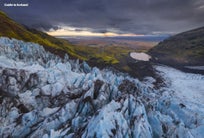
Best Glacier Hikes in Iceland
Glacier hiking in Iceland offers an unforgettable adventure for outdoor enthusiasts. Explore the unique landscape from Iceland's glaciers, where you'll walk across ice formations, crevasses, and frozen terrain. Guided glacier hiking tours provide essential safety gear and expert knowledge, making glacier hiking accessible even for beginners.
Hvannadalshnukur Hike in Vatnajokull National Park
 Photo by Wikimedia, Creative Commons, by Gummao. No edits were made.
A glacier hike to the impressive Hvannadalshnukur mountain requires plenty of energy and guidance from an experienced mountain guide. Hikers must wear a harness and a line, so previous experience with trekking on ice is highly recommended.
The Hvannadalshnukur mountain is 6,923 feet (2,110 meters) with many crevasses and a staggering elevation gain. It's the highest peak in Iceland and part of the Oraefajokull volcanic glacier in Vatnajokull National Park. So, while it's a beautiful hike, you should assess your abilities before attempting this one.
-
Distance: 18 miles (28.6 kilometers)
-
Duration: 12 to 15 hours
-
Difficulty: Difficult
Svinafellsjokull Glacier Hike

Given the high hiking threshold of Hvannadalshnukur mountain, the more popular glacier hike destination is the Svinafellsjokull glacier. It's an outlet glacier of Vatnajokull National Park with many sharp ridges that make for dramatic sights. The high elevation also means seeing all the other glaciers and mountains of the national park and beyond.
Winter is the best time to visit this glacier because, during the winter months, the glacier has a vivid blue color and the chance to see the ice caves. It's perfect for adventurous travelers to Iceland and can be dome wtih this top-rated glacier hiking tour on Vatnajokull.
-
Distance: Varies by tour
-
Duration: 3 to 5 hours
-
Difficulty: Moderate
Falljokull Glacier Hike

The Falljokull glacier is called the "falling glacier" because its massive ice falls make for a stunning sight. It's an outlet glacier of the Oraefajokull glacier in South Iceland and an outlet glacier of the Vatnajokull glacier. If you'd like to explore this unique glacier, join this glacier hiking tour on Falljokull and explore with an expert glacier guide.
-
Distance: Varies by tour
-
Duration: 3 to 5 hours
-
Difficulty: Difficult
Solheimajokull Glacier Hike
 The Solheimajokull glacier in South Iceland is a closer option for those coming from Reykjavik and the most popular glacier hiking spot for beginners. It is close to the infamous Eyjafjallajokull volcano, and glacier hikers might sometimes get a glimpse of it.
The hike is memorable due to the lack of tall mountains around the glacier, which provides an incredible view. The nature of the ice means ice climbing is also possible on this glacier. You can choose this glacier hiking tour to Solheimajokull glacier, or if you are feeling adventurous, combine it with ice climbing tours.
-
Distance: Varies by tour
-
Duration: 2 to 4 hours
-
Difficulty: Easy to Moderate
-
Visit our list of Glacier Tours in Iceland for other glacier activities.
Additional Hiking Spots in Iceland

The regions mentioned above are only a selection of the best hiking trails available in Iceland. Those planning to visit will be happy to hear that pretty much wherever you go in Iceland, there is an excellent place for hiking or a nice walk.
Other notable regions with unique hiking spots include the area surrounding Lake Myvatn, such as the Dimmuborgir lava field and Hverfjall volcano, various locations in South Iceland, the coastlines of the southern part of the Eastfjords, the Snaefellsnes peninsula, and more areas in the Icelandic Highlands, such as the Kerlingarfjoll mountain range or Hveravellir geothermal area.
So don't wait any longer, and start planning your hiking experience in Iceland. Explore the majesty of the land of fire and ice for yourself!
Did you enjoy our article about hiking in Iceland? What hiking routes would you want to experience during a visit? Please feel free to share any thoughts or questions you might have in the comment section below!


บทความอื่นที่น่าสนใจ

แผนที่ประเทศไอซ์แลนด์
มาดูแผนที่ของประเทศไอซ์แลนด์ที่คุณจำเป็นต้องใช้กัน แผนที่นี้ประกอบด้วยสถานที่ท่องเที่ยวในไอซ์แลนด์ 20 แห่ง ซึ่งเราได้จัดทำแผนที่ท่องเที่ยวสถานที่สำคัญของไอซ์แลนด์บน Google Maps ให้ด้วย เพื่อช่วยให้ค...อ่านเพิ่ม
สภาพอากาศและอุณหภูมิในประเทศไอซ์แลนด์
ศึกษาทุกอย่างเกี่ยวกับสภาพอากาศในประเทศไอซ์แลนด์ เนื่องจากเกาะแห่งนี้สุดโต่งในทุกด้าน ไม่เว้นแม้แต่สภาพดินฟ้าอากาศ ดูอุณหภูมิเฉลี่ยของแต่ละเดือน สภาพอากาศของแต่ละฤดูกาล ความแตกต่างของสภาพอากาศในแต่ละพ...อ่านเพิ่มคู่มือเที่ยวธารน้ำแข็งในไอซ์แลนด์
เพลิดเพลินกับความมหัศจรรย์ของธารน้ำแข็งยุคโบราณซึ่งเป็นทัศนียภาพอันยิ่งใหญ่และงดงามของไอซ์แลนด์ สัมผัสประสบการณ์การไฮกิ้งขึ้นไปชมสิ่งมหัศจรรย์ที่หาชมได้ยาก เดินสำรวจตามรอยแยกบนผืนน้ำแข็ง และปีนป่...อ่านเพิ่ม


ดาวน์โหลดตลาดการท่องเที่ยวที่ใหญ่ที่สุดของไอซ์แลนด์ลงในโทรศัพท์ของคุณเพื่อจัดการการเดินทางทั้งหมดของคุณได้ในที่เดียว
สแกนรหัส QR นี้ด้วยกล้องในโทรศัพท์ของคุณแล้วกดลิงก์ที่ปรากฏขึ้นเพื่อเพิ่มตลาดการท่องเที่ยวที่ใหญ่ที่สุดของไอซ์แลนด์ไว้ในกระเป๋าของคุณ ป้อนหมายเลขโทรศัพท์หรือที่อยู่อีเมลของคุณเพื่อรับ SMS หรืออีเมลพร้อมลิงก์ดาวน์โหลด