What are the top attractions on Iceland’s South Coast? What activities can you do in this stunning region? How far is it from Reykjavik? Can you explore it year-round? Discover everything you need to know in this Ultimate Guide to Iceland’s South Coast.
Heading out to explore Iceland’s stunning South Coast is a must-visit region for travelers, and it’s easy to see why. This captivating area is home to some of the country’s most iconic and breathtaking natural wonders. These include the world-famous Jokulsarlon Glacier Lagoon, the vast Reynisfjara Black Sand Beach, and the breathtaking Vatnajokull National Park.
Why You Can Trust Our Content
Guide to Iceland is the most trusted travel platform in Iceland, helping millions of visitors each year. All our content is written and reviewed by local experts who are deeply familiar with Iceland. You can count on us for accurate, up-to-date, and trustworthy travel advice.
Discover the endless natural beauty and fun experiences waiting for you with a variety of guided tours of the South Coast. Each option offers a distinct way to experience the region’s stunning landscapes and iconic sights. This makes it easy to create memories that will last a lifetime.
For an unforgettable winter adventure, embark on the best ice cave tour in Vatnajokull, where you’ll step into a dazzling world of crystal blue ice. They're located on Iceland’s largest glacier and offer great opportunities for incredible photographs!
In the summer, go for an incredible boat trip in Jokulsarlon, gliding past massive icebergs floating in the glacier lagoon. Whether you prefer a guided tour or a self-drive journey by renting a car, the South Coast offers countless breathtaking sights and experiences.
Just be sure to book your accommodations on the South Coast early, as hotels in this popular region fill up quickly, especially during the peak summer months. Keep reading for expert tips to help you plan your South Coast adventure and make it the highlight of your Iceland trip!
What to Know About Exploring Iceland's South Coast
The South Coast of Iceland is one of the most captivating and diverse regions in the country, offering a stunning mix of dramatic landscapes, exciting activities, and rich cultural heritage. With towering waterfalls, expansive glaciers, black sand beaches, and quaint fishing villages, this region is packed with unforgettable experiences.
Driving from Reykjavik to the South Coast’s iconic Jokulsarlon Glacier Lagoon typically takes four to five hours. Of course, this is under good weather and road conditions, without stops.
Spanning approximately 236 miles (380 km), the journey time can vary based on weather, road conditions, and how often you stop to take in the sights. Given the South Coast’s incredible attractions, many travelers opt to spread the trip over two to three days or more. That way, they can fully enjoy and appreciate the region’s beauty.
For those planning a self-driving round trip back to Reykjavik, don’t forget to account for the return drive and plenty of exploration time. Alternatively, you can extend your adventure by continuing East along Iceland's Ring Road for even more unforgettable experiences.
Alongside the iconic Golden Circle, the South Coast is one of the most popular regions to explore in Iceland. Whether you’re an adventure seeker, a nature enthusiast, or simply in search of breathtaking scenery, the south of Iceland has something to captivate every traveler.
Read on to find everything you need to know to plan the ultimate South Coast journey, including must-visit attractions, top activities, and main towns and villages to explore. Let's make your adventure nothing short of extraordinary.
Must-See Highlights on Iceland's South Coast
The South Coast of Iceland is filled with incredible attractions that every traveler arriving in the country should experience. Whether you join a guided South Coast tour or drive along Route 1 at your own pace, this scenic journey is packed with unforgettable highlights. Read on to discover the must-see stops along the way:
Seljalandsfoss Waterfall

Seljalandsfoss waterfall is considered an iconic stop on the South Coast sightseeing route, because visitors can walk behind the cascading water. This makes the feature particularly beloved by nature photographers. They jump at the chance to capture the waterfall from behind.
Standing at an impressive 197 feet (60 m) high, Seljalandsfoss is one of Iceland's most iconic waterfalls. Its water originates from the Eyjafjallajokull Glacier, a name many recognize due to its 2010 eruption. This eruption not only disrupted European air traffic but also played an important role in sparking Iceland's tourism boom.
Visitors to Seljalandsfoss will often continue north along the trail until they discover Gljufrabui Waterfall, another small cascade hidden away inside a gorge in these ancient sea cliffs. Once again, photographers jump at the chance to photograph Gljufrabui and its unique surroundings.
Join a small-group South Coast tour from Reykjavik and visit this iconic landmark along with other must-see attractions along the south. You can also opt to explore this beautiful waterfall at your own pace on a one-week winter self-drive tour along the south of Iceland.
- See also: Top 20 Beautiful Waterfalls of Iceland
Skogafoss Waterfall

Skogafoss is one of the largest waterfalls in Iceland, boasting a drop of 196 feet (60 m) and a width of 49 feet (15 m), and it's one of the major attractions along the South Coast.
Visitors to Skogafoss can walk right up to where the cascading water crashes into the ground, making for fantastic photographs. Photos are made even more amazing by the sheer size of the mist and spray clouds constantly formed by the waterfall, creating rainbows in the light.
Standing in such proximity also allows you to experience the sheer power of this natural feature. Be careful during the winter months, however, as the rocks at the base of Skogafoss often become incredibly slippery due to ice and constant mist from the falls, making it dangerous to approach.
It is also possible to view the waterfall from the top if you choose to ascend the staircase right beside it. However, in winter, these stairs often become covered in snow, making them difficult to access.
Because Skogafoss is found a short distance from Seljalandsfoss, the waterfalls are often paired together in travel guides and considered cousins. Like Seljalandsfoss, Skogafoss has made numerous appearances in the media. Some you might recognize include the History Channel’s "Vikings" and the film "The Secret Life of Walter Mitty."
- Check out Movie Locations in Iceland: The Complete List
- See also: Top Activities in Iceland for Adrenaline Junkies
Solheimajokull Glacier
A short drive along a gravel road on the left-hand side of the Ring Road takes you towards Solheimajokull Glacier. This is the meeting place for anyone looking to do a glacier hike on this impressive glacier, which is a part of the larger Myrdalsjokull Glacier.
Embarking on a glacier hike is a thrilling way to experience Iceland's natural beauty, and it's essential to do so with a certified guide for safety. Glaciers are fascinating but complex landscapes with hidden crevices and unique challenges that require expert navigation.
Every participant on a glacier hike is equipped with all the necessary gear, including crampons, helmets, and ice axes, to ensure a safe and enjoyable adventure.
For those new to this exciting activity, don’t miss the chance to join a glacier hike tour for beginners. It's perfect for experiencing the magic of Iceland's icy terrain in the safest and most memorable way.
However, if you aren't looking to go on a hike on the glacier, it's still a beautiful sight to see from a distance. From the parking lot, there's a 15-minute walk to the edge of the glacier tongue, along impressive mountains and the glacier lagoon nesting in front of it.
Dyrholaey Peninsula

Dyrholaey’s origin story can be traced back to when it was a volcanic island separate from mainland Iceland. Today, Dyrholaey is connected to the rest of the country, becoming a small peninsula unto itself.
This coastal cliff is best known for its fantastic views over Iceland’s South Coast, as well as the birdlife that utilizes Dyrholaey’s towering cliff faces. You'll also discover an enormous rock arch that dominates the scene!
Those traveling to Dyrholaey for the views will be in for a sure treat. To the north, you will be able to see Myrdalsjokull glacier, while to the east and west, respectively, you will have views over Reynisdrangar and the southern coastline towards the town of Selfoss.
Note that parts of Dyrholaey are closed off during May and June to leave the nesting birds undisturbed. Guests looking to see birdlife can observe a variety of species, including puffins. However, be mindful of the Arctic Tern, which is known to divebomb aggressively when protecting its nests.
- See also: Dyrhólaey - The Arch with the Hole
- Read more about Wildlife and Animals in Iceland: The Complete Guide
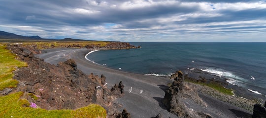
Reynisfjara Black Sand Beach

Reynisfjara is a black sand beach found between the village of Vik and Dyrholaey Peninsula, roughly 112 miles (180 km) away from Reykjavik. Known for its striking volcanic coastline, it's become one of the most popular stop-off points for sightseeing tours along the South Coast.
Visitors can marvel at this ancient and mystical landscape, characterized by distant mountain vistas, dramatic cliffs, and striking rock formations. In 1991, National Geographic recognized Reynisfjara as one of the world's top 10 most beautiful non-tropical beaches.
Of particular note are the 49-foot (15-meter) high rock stacks, Reynisdrangar, which rise from the ocean just off the coastline. Over the years, much folklore has surrounded Reynisdrangar. Some claim them to be the petrified remains of three trolls, frozen solid in the sunlight as they attempted to pull a boat from the water. Others believe it is the frozen imprint of a long-lost, three-masted ship.
Another story suggests Reynisdrangar is all that's left of a troll, frozen by a vengeful husband after learning that it had murdered his wife.
Whatever the case may be, Reynisdrangar is home to a wealth of nesting seabirds, including puffins, fulmars, and guillemots. While walking along the coast, travelers will also observe the hexagonal rock formations that decorate the cliffsides running along the length of Reynisfjara, known as Gardar.

Reynisfjara beach is a breathtaking destination, but it’s important to approach it with caution. The beach is known for its powerful and unpredictable waves, often referred to as “Sneaker Waves” or “Rogue Waves,” which can suddenly surge up the shore.
These waves, combined with Reynisfjara's strong currents and icy water, make it crucial for visitors to stay vigilant. Paying close attention to the warning signs and keeping a safe distance from the shoreline will ensure you can fully enjoy this stunning location while staying safe.
In February 2026, the beach experienced an unprecedented level of erosion. With a higher sea level, parts of the beach are now inaccessible, but you can still enjoy the stunning views of the basalt columns and Reynisdrangar Sea Stacks. You can learn more in our Reynisfjara travel guide.
- Learn more about Vikings and Norse Gods in Iceland
- Discover the Things That Can Kill You in Iceland (Plus Sand Snakes)
- See also: 8 Amazing Black Sand Beaches in Iceland
Skaftafell Nature Reserve

Skaftafell is a preservation area located in the Oraefi region of Southeast Iceland. Skaftafell was once a national park in its own right, having been established in 1967. As of June 2008, it was incorporated into the enlarged Vatnajokull National Park.
Skaftafell was originally inhabited as a farmstead not long after the initial settlement of Iceland and was even the location for a number of administrative meetings between different Chieftains.
The 1362 eruption of Oraefajokull Glacier destroyed the community in its entirety, making the area uninhabitable for long periods of time. Since then, the area has been referred to as “the wasteland” or Oraefi in Icelandic.
Farmsteads continued to be re-established in the area. However, each was met with new challenges. Some of these range from infertile soil to frequent glacial flooding and ash clouds from the nearby volcano, Grimsvotn. Farming was finally discontinued in the region in 1988.
Today, the area is known for its stunning natural beauty, which includes the tallest peak in Iceland, Hvannadalshnukur. While there, you can also see the country's tallest waterfall, Morsarfoss. There's a stark contrast between the green birch-clad fertile ground right next to the enormous Vatnajokull glacier, making this one of Iceland's most popular hiking areas.
A short hike from the visitor center leads to Svartifoss Waterfall, though the most popular activities in the area are the glacier hikes. Skaftafell also has a beloved campsite, a welcoming visitor center, and a cozy café for travelers to enjoy.
Vatnajokull National Park

Vatnajokull is the largest glacier in both Iceland and Europe, with a total surface area of 3,127 square miles (8,100 square km). Vatnajokull reaches a maximum ice width of approximately 3,280 feet (1,000 m) and boasts over thirty different outlet glaciers.
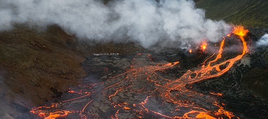
Vatnajokull National Park covers approximately 11% of Iceland, blanketing canyons, mountains, and even volcanoes. As such, it proves to be an excellent example of why the country is known as the "Land of Ice and Fire."
Some of the island's most active volcanoes currently rest beneath the glacier, including Grimsvotn, Oraefajokull, and Bardarbunga. Scientists expect there to be a high level of volcanic activity in Vatnajokull over the next half-century.

Vatnajokull is just one of the three national parks in Iceland, but it is, without doubt, the largest, having absorbed both the historical Skaftafell National Park and Jokulsargljufur Canyon.
The other national parks in the country are Thingvellir National Park, part of the Golden Circle route, and Snaefellsjokull National Park.
Vatnajokull National Park was established in 2008 to protect the area’s wildlife. It's so enormous that there are countless things to see, do, and enjoy there! In particular, ice-caving tours in winter and glacier hiking all year round are the most popular activities. Most of the park is within the Icelandic Highlands, meaning a four-wheel drive car is needed to reach its remote parts.
- See also: National Parks in Iceland
- Read all about The Top 5 Places to Visit in the Icelandic Highlands
Gullfoss Waterfall
 Gullfoss is a breathtaking two-tiered waterfall located in South Iceland, and it's one of the highlights along the iconic Golden Circle sightseeing route.
The Hvita River plunges into a rugged canyon in two dramatic stages, dropping a total of 32 meters (105 feet) into a narrow gorge carved out by glacial floods over centuries. On sunny days, the resulting mist often produces vibrant rainbows, adding to the surreal beauty of the scene.
Visitors can explore a series of marked walking paths that offer various vantage points, from sweeping panoramic views above to close-up glimpses of the roaring cascade. The upper and lower platforms provide safe access during the warmer months, making Gullfoss one of the most photographed and memorable natural attractions in the country.
In winter, the landscape transforms into a frozen wonderland, with ice-covered rocks and snow-dusted cliffs giving the falls an entirely different character. Whether you visit in the glow of summer or under a frosty winter sky, Gullfoss showcases the raw, untamed power that defines much of Iceland’s natural beauty.
Jokulsarlon Glacier Lagoon

Jokulsarlon Glacier Lagoon offers some of Iceland’s most breathtaking scenery. This serene area is defined by its tranquil icebergs and playful seal colonies. Not to mention, its panoramic views of the ice caps and mountains within Vatnajokull National Park are also gorgeous. It’s easy to see why Jokulsarlon is often called “The Crown Jewel of Iceland.”
The lagoon is always increasing in size, as it is formed by the glacier calving large chunks of ice into the lagoon. Due to global warming, this phenomenon is rapidly increasing.
Driving here from Reykjavik takes approximately four and a half hours without stops, so a round trip would be about nine hours. However, you'll surely want to make several stops along the way.
Jokulsarlon is now Iceland's deepest lagoon, reaching depths of up to 248 meters (814 feet). It began forming around 1934–1935 and now covers about 6.9 square miles (18 square kilometers). Since the 1970s, it has grown to four times its original size.
Most visitors choose to spend the night at accommodations along the South Coast, either at Hofn, Vik, or Hvolsvollur. With that being said, some do choose to make the trip in a single day. The journey is especially breathtaking during the summer months when the Midnight Sun allows for nearly 24 hours of illuminated sightseeing.

Just be aware that it's an extensive trip to make in a single day, as there are countless other attractions to be found along the way. If Jokulsarlon is the "Crown Jewel," it’s also the "Prize," the gold at the end of the winding rainbow we call the Icelandic South Coast.
During the summer months, you can embark on an unforgettable boat tour through the breathtaking Jokulsarlon Glacier Lagoon, gliding among its magnificent, floating icebergs.
In winter, the best ice cave tours in Iceland depart from Jokulsarlon, so you'll be able to see more than one natural wonder during a visit. On this ice-caving tour in the Vatnajokull Glacier, you can see the incredible Western Ice Cave's crystal ice formations and blue colors. Additionally, you can also view the striking Eastern Ice Cave, known for its large size!
There are plenty of unforgettable experiences to be had in the area, no matter the time of your visit. Discover a variety of Jokulsarlon tours that showcase the beauty of the glacier lagoon and its surrounding wonders.
- Discover more about Glacier Lagoons in Iceland
Diamond Beach

Just a five-minute walk from Jokulsarlon Glacier Lagoon lies the mesmerizing Diamond Beach, a stretch of coastline where glistening icebergs wash ashore on the jet-black volcanic sand.
This captivating spot is a favorite among photographers, who are drawn to the stunning contrast between the shimmering blue ice and the dark, dramatic shoreline. It's a marvelous scene that’s nothing short of magical!
Thanks to the icebergs' natural formation, no photo is ever alike, and the rolling tide presents a fantastic chance to experiment with timelapse. This creates fantastic and surreal pictures that perfectly capture the area's unique, ethereal nature.
Make sure to visit this magical landmark and include a stop at the stunning Diamond Beach as part of your unforgettable South Coast adventure in Iceland. You won't regret it, nor will you ever forget it!
- See more: South Coast Jokulsarlon Glacial Lagoon
Hidden Gems Along the South Coast
 The South Coast of Iceland is not just about its famous attractions as it’s also home to incredible hidden gems waiting to be discovered. Here are some of the South Coast’s best-kept secrets and scenery to add to your itinerary:
Reykjadalur Valley

Translated as “Steam Valley,” Reykjadalur is best known for its soothing hot river, a natural wonder created by the area’s rich geothermal activity. However, the valley itself is just as remarkable.
Its lush green hillsides are interspersed with trickling streams and cascading waterfalls. Additionally, you'll find the area dotted with numerous hot pools and geothermal springs, making it a true haven for nature lovers.
Reykjadalur is located near the charming town of Hveragerdi, home to about 2,500 friendly residents who are always happy to help visitors find their way. Just a 40-minute drive southwest of Reykjavik, Hveragerdi is the perfect gateway to this stunning geothermal paradise.

After reaching Hveragerdi, visitors will drive straight through the town until they arrive at the gravel road that leads up to Reykjadalur valley. Cars are parked at the end of this gravel road, from where guests hike for 2 miles (3 km) uphill until they reach the first areas for bathing.
Note that different sections of the river come out at different temperatures, so walk up and down a little to find the most comfortable spot for you.
A bus goes to Hveragerdi, but not to the parking area where the hike begins. So, the best way to get here is by renting a car or joining a tour, such as this horseback riding and hiking tour from Reykjavik.
- See also: Top 9 Things to Do in Hveragerdi
Seljavallalaug Outdoor Pool

Just 14.3 miles (23 km) east of the iconic Seljalandsfoss Waterfall lies one of the South Coast’s hidden gems: the Seljavallalaug Pool. The pool was constructed in 1923 and is one of Iceland’s oldest swimming pools, a piece of the country’s history.
Once Iceland’s largest swimming pool, measuring 32.8 feet (10 m) wide and 82 feet (25 m) long, Seljavallalaug held the title until 1936. Despite its modest size by modern standards, this scenic pool remains a beloved stop along the South Coast, and it’s free to enter.
Visitors should note that bathing in the pool is at their own risk, as the water, fed by natural trickles from the mountainside forming one of its walls, is lukewarm at best. Still, Seljavallalaug’s unique charm and tranquil setting make it a memorable detour for those exploring the region.
Many visitors pay a little too close attention to the strange green shade the pool water often takes. This is caused by the algae that grow on the pool’s sides and bottoms.
Visitors are required to take all trash with them from the site and leave nothing behind. There are no showers or bathrooms on-site. However, there is a small house where visitors can seek shelter and change clothes. That's also up to visitors to leave neat and tidy.
Getting there requires you to take a left turn off the Ring Road onto Road 242 until you come to a parking lot. From the parking lot, it's a 15–20 minute walk along an unpaved path to reach the pool.
- See also: Best Swimming Pools in Iceland
DC-3 Plane Wreck in Solheimasandur

For many years, the US Navy DC-3 Plane Wreck has sat abandoned and left to the elements. As a result of a possible fuel failure in 1973, the aircraft crashed into the black sand desert of Solheimasandur, located between Hvolsvollur and the fishing village of Vik i Myrdal. Thankfully, there was no loss of life during the incident.
It has sat there ever since, exposed and jagged, creating a stark contrast with the landscape, with the plane's peeling white paint standing against the dark volcanic earth of Solheimasandur. Additionally, the plane's mechanical, man-made nature greatly contrasts with the open, untouched environment that has become its resting place.
- See also: The abandoned DC plane on Sólheimasandur
Given the plane’s presence since the early seventies, some Icelanders are only now beginning to accept that the DC Plane Wreck has become a makeshift visitor attraction in itself. Until fairly recently, the wreckage was considered as something of a mess, if considered at all. It is only with foreign eyes that the wreckage has become a real point of interest.
To get there, you will need to put in a bit of effort. The plane cannot be seen from the Ring Road, and it's illegal to drive to it.
The best way to visit the DC-3 plane wreck is by joining an ATV tour starting from the Myrdalsjokull Glacier Base, offering both adventure and convenience. Alternatively, you can shuttle to the plane wreck site, saving yourself the challenging and lengthy walk to this iconic location.
Fjadrargljufur Canyon

Fjadrargljufur Canyon holds a 1.2-mile (2 km) long river in South Iceland and is approximately 328 feet (100 m) deep, with steep walls and narrow pathways. Fjadrargljufur, notoriously unpronounceable for foreigners, is pronounced as [Fyath-raor-glyu-fur].
Fjadrargljufur Canyon has changed a lot over the nine thousand years it has existed. Today, guests can take the walking path above the canyon to admire it. Entering the canyon itself is now strictly forbidden to protect the environment.
The bedrock of Fjadrargljufur is palagonite, dating back to cool periods during the last Ice Age, approximately 2 million years ago. The canyon has taken on its strange and winding shape due to the river Fjadra, which begins at the mountain Geirlandshraun.
Visitors are urged to respect the path that winds itself on top of the canyon. Stepping off the path damages the delicate grass and moss found there.
- See also: Top 11 Amazing Canyons in Iceland
Dverghamrar (“Dwarf Cliffs”)

Dverghamrar (“Dwarf Cliffs”) is an area of hexagonal basalt columns found in South Iceland, approximately 6 miles (10 kilometers) east of Kirkjubaejarklaustur. Dverghamrar is a protected national monument.
Dverghamrar is an excellent example of how mysterious and puzzling Icelandic nature can be, a fact driven home by the attraction's mythological name. According to Icelandic folklore, Dverghamrar was once the home of dwarves, elves, hidden folk, and all other supernatural beings.
Rutshellir Cave

Rutshellir Cave is a surprisingly spacious man-made cave near the village of Skogar. This South Iceland cave likely served as a shelter or storage space a long time ago.
When you visit Rutshellir cave, you'll see a stone-walled tunnel carved into the rock. This tunnel is 65 feet (20 meters) and gets as wide as 16 feet (5 meters).
This cave is one of the lesser-known yet intriguing places to visit in South Iceland and is ideal for travelers interested in folklore and early settlement history. It's believed that the cave was first inhabited by a man named Rutur, though the accounts vary widely.
Skogar Museum

Skogar Museum is located in the village on the South Coast of Iceland that bears the same name. The museum has three distinct sections covering unique topics, including tools, historical artifacts, and turf houses in Iceland. While here, you can learn how people lived in Southern Iceland centuries ago.
The collection spans over 18,000 artifacts that provide deep insight into local traditions and crafts. Skogar Museum is one of the top South Iceland attractions for visitors seeking authentic cultural experiences.
- See more: The Best Museums in Iceland
- See also: Best Culture Tours in Iceland
Thorsmork Valley
Thorsmork is a lush mountain valley surrounded by glaciers and volcanoes in South Iceland. You can hike scenic trails, cross glacial rivers, and explore rugged landscapes. The valley is accessible only by highland vehicles, adding to the adventure.
Thorsmork lies between three glaciers and is popular for multi-day trekking routes like the Laugavegur Hiking Trail. It remains one of the top things for outdoor enthusiasts and hikers to do on the South Coast of Iceland.
Raufarholshellir Lava Tunnel

Raufarholshellir Lava Tunnel is one of the longest lava tubes in Iceland's South Coast. Inside, you walk through colorful rock formations created by past volcanic eruptions. Guided tours provide helmets and lights for safe exploration.
The tunnel is about 4,500 feet long and includes ice formations in winter. It is one of the most remarkable sights in South Iceland.
Kirkjugolf (“The Church Floor”)

Kirkjugolf (“The Church Floor”) is an 861 square feet (80 square meters) stretch of columnar basalt rock imprinted in a field just east of Kirkjubaejarklaustur Village. Despite this attraction's name, Kirkjugolf is entirely natural. Its creation was the result of a cooling lava flow that becomes contracted and then cracks into a series of separate hexagonal columns.
Thus, there has never been a church on the site, merely an allusion to one. Despite this, the entire area has a history deeply rooted in mysticism. For example, it's said that the town was so enchanted and sacrosanct to the early Christian settlers that pagans could not set foot there.
Charming Towns to Visit on the South Coast
 The South Coast of Iceland is dotted with charming towns that provide a window into the region’s rich culture and history. These welcoming stops are ideal for taking a break from the road. At these stops, you can enjoy delicious local cuisine, relax in geothermal pools, or discover cozy accommodations to spend the night.
Here are some must-visit towns to explore along the South Coast:
Selfoss New Old Town

Selfoss is the largest town on the South Coast of Iceland and a popular stop while exploring the region. You'll pass through it as you drive along the Ring Road, and it's an easy addition to any Golden Circle itinerary. It's a great place for lunch or dinner on your travels, but it's also an attraction in its own right!
The Selfoss Center, known as the New Old Town, has restaurants, cafés, bars, shops, and the popular Skyrland Exhibition, all of which make for a great addition to your big day of exploration. It features many historic Icelandic houses from all around the country that don't exist anymore and have been rebuilt to create a new picturesque town center.

At the heart of the Selfoss Center is the Old Dairy Food Hall, located in a beautiful and historic dairy factory. It features diverse restaurants and bars, making it the perfect spot for a casual, quick, and tasty meal.
If you want a sit-down restaurant experience in Selfoss, there are also multiple options in New Old Town. One of the best restaurants on the South Coast is Mar Seafood, where you can enjoy fresh local fish in an ocean-inspired setting.
For something sweet, stop at the iconic Ísbúð Huppu, an ice cream store famous for its glorious ice cream mix-ins.
Take the chance to browse the charming shops in the area and enjoy the lively atmosphere. The town center is a great addition to any self-drive tour of the South Coast or Golden Circle area. You can also find great accommodations in Selfoss to serve as a base while you explore the area’s top sights!
- Check out the Top 8 Things to Do in Selfoss
- See also: Top 6 Restaurants on the South Coast of Iceland
Vestmannaeyjar (Westman Islands)

Vestmannaeyjar, or the Westman Islands, is an archipelago found off the South Coast of Iceland. The name alludes to the area's first settlers, Irish monks, or "Men from the West."
Vestmannaeyjar comprises 15 islands, as well as around 30 sea stacks and skerries. They are thought to have formed 10,000-12,000 years ago, making them quite young in geological terms.
The largest island, Heimaey, is the only one within the archipelago that is inhabited, currently boasting a population of approximately 4600 people. The other islands are either completely untouched by human hands or sport a solitary hunting cabin. Additionally, they only take visitors in the warm summer months.

One particular draw that attracts guests to the Westman Islands is its natural biodiversity, where you'll find many of Iceland's seabird species! These birds of Iceland include guillemots, skuas, Arctic terns, puffins, and kittiwakes.
Thanks to the area's unique microclimate, millions of birds nest on the islands' cliffs each spring, departing again at the end of summer. The puffin, a key part of this vibrant birdlife, has even been officially adopted as the symbol of Vestmannaeyjar. You can experience this incredible wildlife up close on a one-hour boat tour from Heimaey Harbor.
You can take a ferry to the Westman Islands from Landeyjahofn Harbor, with the option to bring your car. However, Heimaey Island is easily walkable, so bringing a car isn't necessary.
The ferry trip takes about 35 minutes one way, and it's recommended to book in advance. Alternatively, you can fly from Reykjavik Domestic Airport to Vestmannaeyjar on a one-hour flight
- Discover the Top Things to Do in the Westman Islands (Vestmannaeyjar)
- Read all about Where to See Puffins in Iceland
Vik i Myrdal Village
Vik I Myrdal is a small coastal village found on Iceland’s South Coast, often utilized as a lunch stop and souvenir shopping destination for those partaking in a sightseeing tour. Some choose to stay in Vik accommodations to enjoy what the town has to offer.
The village is home to approximately 320 people, yet stands as the largest settlement in a 43-mile (70-km) radius. Because of this, Vik I Myrdal is considered an important staging post and administrative center between Skogar and the Myrdalssandur Glacial Plain.
Vik i Myrdal is located directly south of Myrdalsjokull Glacier, meaning it is under constant threat from the Katla Volcano, which sits beneath the ice cap. Katla has not erupted since 1918, which, according to scientists, means the chance of a new eruption increases with each day. However, it may take many years until the next one takes place.
- Check out the Top 9 Things To Do in Vik
- See also: Glaciers in Iceland
Katla Volcano, one of Iceland's most powerful natural features, adds an element of intrigue to the picturesque town of Vik i Myrdal. Thanks to its elevated location, the iconic red-roofed Vik Church is considered a safe haven in the unlikely event of glacial flooding.
The community is well-prepared for this sort of emergency and holds regular evacuation drills to ensure the safety of its residents. Visitors staying in Vik's hotels are informed about the volcano's history and can rest assured knowing there hasn’t been an eruption in over 100 years.
In the meantime, Katla remains quiet, offering visitors the unique opportunity to embark on year-round excursions to explore the area around the volcano. Some highlights include breathtaking natural ice caves nestled within the glacier that crowns Katla. In other words, every visit to Vik is a memorable adventure!
- Learn about the Top 7 Restaurants in Vik
- See also: Katla Volcano Ice-Caving & Glacier Hiking Tour with Transfer from Vik
Kirkjubaejarklaustur Village

Kirkjubaejarklaustur, often known as simply “Klaustur,” is a small village found on Iceland’s South Coast, to the east of Vik i Myrdal, in the municipality of Skaftarhreppur.
This village, with a population of approximately 200 people, is the only location between Vik and Hofn. There are several local amenities that travelers can utilize here, including a petrol station, supermarket, restaurants, and a swimming pool.
Kirkjubaejarklaustur has a long and important history in Icelandic culture. Some believe that Kirkjubaejarklaustur was home to Irish Monks before the Norsemen arrived. Then, in 1186, an important convent of Benedictine nuns called the village home until the Reformation in the mid-1500s.
Kirkjubaejarklaustur is surrounded by the magnificent Eldhraun, the largest lava flow in the world, which was made during the 1783-1784 eruption of Lakagigar. The story goes that the town was saved from destruction thanks to the famous "Eldmessa" or "Fire Sermon".
This Eldmessa was performed by the local priest, Jón Steingrímsson, who called on divine intervention to stop the lava before it could reach the town. Today, visitors can see the 1924 memorial chapel built as a testimony to this incredible event.
- Learn about Volcanic Eruptions in Iceland: A Complete Timeline
- See also: The Ultimate Guide to the Highlands of Iceland | Where They Are and How to Visit
Hofn i Hornafirdi

Hofn i Hornafirdi (often shortened to simply "Hofn") is a fishing village in Southeast Iceland, sitting in the Hornafjordur Fjord. Between 1994 and 1998, the village was known officially as Hornafjardarbaer before taking the name it is known by today, meaning “Harbor.”
The village is currently the second-largest urban settlement in Southeast Iceland and has incredible views over the Vatnajokull Glacier and the stunning Vestrahorn Mountain. The surrounding landscape is characterized by shifting shoals and glacial rivers. You can also see several small islands lying to the east of the village, such as Mikley and Krokalatur.
- Learn more: Top 9 Things to Do in Hofn
- See also: The Ultimate Guide to Iceland's East Fjords

Hofn I Hornafirdi is often utilized for overnight stops on tours traveling along the South Coast. The town is notably used by those venturing as far as Jokulsarlon glacier lagoon or for anyone continuing east rather than returning west to the capital.
- Read all about the Best Places to Visit in East Iceland
- See also: Top 6 Restaurants in East Iceland
Take the South Coast Further
 The South Coast makes for an unforgettable trip on its own, but it also serves as the heart of some of Iceland's best multi-day itineraries. These tours weave through the South Coast as part of a wider journey across Iceland, combining iconic southern highlights with destinations across the Ring Road, the Snaefellsnes Peninsula, and beyond.
-
6-Day Guided Adventure Around Iceland's Full Ring Road — Cover Iceland's most iconic highlights, from the South Coast and Glacier Lagoon to Lake Myvatn, with an expert guide handling everything along the way.
-
8-Day Guided Tour of the Complete Ring Road & Snaefellsnes Peninsula — Take the full Ring Road at a relaxed pace, with extra time to explore the South Coast, the remote East Fjords, and the dramatic landscapes of Snaefellsnes.
-
1-Week Self-Drive Tour of West & South Iceland with the Golden Circle — Combine the South Coast with the Golden Circle and Snaefellsnes on this summer road trip, with a rental car and accommodations included.
-
7-Day Northern Lights Self-Drive Tour of South Iceland, the Golden Circle & Snaefellsnes — Chase the aurora on a winter self-drive through the South Coast and beyond, with a ready-made itinerary and 24/7 support throughout.
Plan Your South Coast Adventure
 Iceland’s South Coast is packed with iconic sights and hidden gems, from waterfalls and glaciers to black sand beaches and coastal villages. Whether you’re self-driving or joining a guided tour, planning ahead ensures a smoother, more rewarding trip.
Book early, take your time, and get ready for an unforgettable adventure in one of Iceland’s most breathtaking regions.
Have you visited Iceland's scenic South Coast, and if so, what was your favorite location? Are there any handy hints that you'd like to share with future travelers to South Iceland? Make sure to leave your thoughts and queries in the comment section below.

I was the Content Manager at Guide to Iceland from 2013 to 2018, and now run the creative studio Huldufugl while working as a freelance writer. I’m passionate about storytelling, Icelandic culture, and creating thoughtful experiences through words and visuals.