Where can you find the most beautiful landscapes in Iceland? How were the landscapes of Iceland formed, and how are they changing? What is the best way to access these otherworldly regions? Continue reading for the ultimate guide to Icelandic landscapes.
Iceland is one of the few countries in the world that resembles no other. Shaped by millennia of volcanic activity, extreme weather, and the workings of mighty glaciers, it’s landscapes are as diverse as they are spectacular.
Why You Can Trust Our Content
Guide to Iceland is the most trusted travel platform in Iceland, helping millions of visitors each year. All our content is written and reviewed by local experts who are deeply familiar with Iceland. You can count on us for accurate, up-to-date, and trustworthy travel advice.

Black-sand beaches; electric blue ice caps; dramatic fjords; volcanic craters; and endless lava fields can all be found within the country, often just a short drive from each other. Visitors to Iceland are often awed by the diversity of scenery that can be explored within a few hours, even for those staying in Reykjavík going out on day tours.
Part of what makes Iceland’s wilderness so unusual and special in the world is the fact that it is so untouched by human influence. With a population of just over 300,000, two thirds of which live in one urban area, there are vast swathes of nature that seem as old as time.

In spite of the fact that every corner of Iceland has otherworldly natural beauty, visitors will still need to know where to go to seek out certain natural features. There is no use hoping to explore the country’s fjords by travelling the sandy South Coast, for example, or looking for volcanic hot springs in the Westfjords.
Furthermore, you should be aware that certain landscapes, such as those up on the glaciers or in the central highlands, will require you to book specific tours to explore them. Finally, all guests should inform themselves on how to treat Iceland’s wilderness, to protect it for the generations to come and to avoid some hefty fines.
Iceland’s Volcanic Landscapes
Iceland is truly the Land of Ice and Fire, its wilderness forged by these two elements. The first of these was the fire, which brought the country bubbling into the world through the cold seas of the North Atlantic about sixteen million years ago.
This makes Iceland a geologically young country; with its ongoing volcanic activity, it’s still forming. The reason Iceland has this volcanism is due to its position in relation to the tectonic plates; it sits directly above the Mid-Atlantic Rift, which separates the North American and Eurasian continents.

As this rift pulls apart, magma swells to the surface, becoming the lava that forms the base of Iceland’s landscapes.
The Westfjords were the first part of Iceland to form; this explains why the mountains here are flat-topped and sheer-sided, having been weathered by the elements for the longest. It also explains the lack of geothermal activity in this region; it has been pushed away from the active area of the rift.

The rest of Iceland is newer and therefore hot springs, steaming vents and colourful craters are found in almost every corner, particularly around this continental divide. This rift between the tectonic plates can even be seen on the surface at Þingvellir National Park.
Further evidence of the way that Iceland’s volcanoes have shaped the country can be witnessed in its conic volcanoes, dramatic mountain ridges, and countless fields of lava rock and black sand. While they only erupt sporadically, with recent examples being Eyjafjallajökull in 2010, Holuhraun in 2014, and then Fagradalsfjall in 2021 and 2022, and Litli-Hrutur in 2023, their activity is omnipresent throughout the country.
Iceland’s Glacier Landscapes

The second element that has largely shaped Iceland’s landscapes is ice. Due to its position on the edge of the Arctic Circle, it has, throughout its millions of years of history, been shaped by countless glaciers.
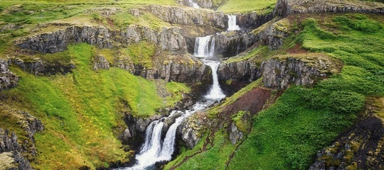
These vast ice caps have carved out fjords and valleys as they have crept down mountains towards the shore. Rivers that cascade from the glaciers have also changed the face of the country.
Interestingly, the amount of the country covered by these natural marvels has been ever-changing; during the last ice age, it was completely covered in an ice sheet that reached mainland Europe. Whereas at other times, there has been no permanent ice. Currently, just over 10% of Iceland is covered in glaciers.

These glaciers form an otherworldly landscape; their colouration is spectacular, ranging from electric blue to deep grey, which is caused by ash from historic eruptions. Due to their elevation, they are also fantastic places from which to admire other parts of the country, should the weather be clear.
They also create some of the country’s most famous natural phenomena: the ice caves and glacier lagoons. The ice caves are an incredibly rare marvel, accessible only in Iceland’s winter months. These ethereal spaces provide an unforgettable opportunity to understand the workings of a glacier from within.

The glacier lagoons, meanwhile, are formed at the base of glaciers, where their meltwater gathers. The most notable of these is Jökulsárlón, which forms a vast lake in south-east Iceland brimming with enormous icebergs.
Many of the landscapes of Iceland are not formed by just the volcanic or glacier activity, but the two working in unison. The devastating, unpredictable floods caused by an eruption beneath an ice cap, called jökulhlaup, result in the haunting stretches of black sands found in the south and Highlands, for example.
The geysers found in Haukadalur Valley, meanwhile, are formed by the meltwater of the glacier Langjökull travelling underground to an area with a high amount of geothermal activity.

Even the minimal amount of forests that cover Iceland’s landscapes has to do with the combined forces of ice and fire. Before settlement, the country was largely covered in birch trees; early Icelanders utilised their abundance for building their homes and fueling their fires.
A few centuries later, Iceland went through a period of intense volcanism, the ash of which significantly cooled the country, creating more glaciers which facilitated even lower temperatures. This prevented the depleted forests from growing back, and turned Iceland into the relatively barren country it is today.

The fact that many areas in Iceland are becoming reforested is also because of the glaciers. The threat of climate change means that the country’s ice caps may only have a few more decades of existence left. However, scientists have discovered that planting trees around them allows the warming air to be absorbed.
Though many worry this is too little, too late, there is still hope that worldwide reforestation efforts may mean that Iceland’s glaciers only retreat temporarily, instead of disappearing forever.
Due to the fact that they are rapidly retreating, many visitors seek to ascend the glaciers for what could sadly be their only opportunity to witness an ice cap in all its majesty. It is only possible to do so, however, on an organised glacier hiking tour.

By booking such an excursion, you are provided with all necessary equipment and are led by an experienced, knowledgeable guide, turning what could potentially be a dangerous activity into one that is fun, safe and informative. Some of these tours also include an ice-climbing component.
The glacier caves formed between November and March can also only be accessed on a guided trip. If you are travelling outside of these months, you can also book an excursion to visit a man-made ice tunnel built into Langjökull glacier.
Iceland’s Landscapes by Season

While every country on earth changes by season, in few places does the time of the year reflect so dramatically on the landscapes as Iceland.
Iceland’s winter landscapes are renowned for being wrapped in a blanket of gleaming snow, with blue ice adorning their spectacular features. Iceland’s summer landscapes, meanwhile, reveal the diversity of the country, with some areas vibrant with colourful flora, others exposed as bleak and barren.

These dramatic seasonal contrasts are due to the tilt of the earth’s axis; in summer, the north pole - and thus Iceland - faces the sun, providing twenty-four hours of daylight. In winter, the country leans towards the darkness of space, the sun only creeping over the horizon for hours at a time.
Of course, in the latter season, Iceland experiences the incredible phenomena of the Aurora Borealis, which make the otherworldly landscapes even more ethereal. Admiring the Northern Lights dancing in the sky anywhere is a once-in-a-lifetime experience, but to do so from a steaming valley of hot springs, or a beach of haunting black sands is something that only Iceland can offer.

Even the country’s glaciers look vastly different between the seasons. In winter, they are coated in newly frozen ice, which gleams a vivid blue; in summer, the older ice is exposed, which is veined with black ash.
Most Icelanders only consider the country to have two seasons, summer and winter, due to the speed between which one departs and the other sets in. Before planning a trip to Iceland, be sure to consider whether you want to see its landscapes clad in their Arctic colours beneath a canopy of Northern Lights, or basked in the Midnight Sun for endless hours of exploration.
Protecting the Landscapes of Iceland

Before illustrating the diversity and beauty of Iceland’s landscapes by region, it is important to know a few rules about protecting them. Not only will this ensure that the country will remain as spectacular for the generations to come, but it’ll protect your wallet. Icelanders are justifiably very protective over their nature, and the fines for damaging it are extortionate.
-
Never drive off-road: Iceland’s landscapes have taken millennia to form, and will never look the same if they are damaged. It is essential to stay on the roads at all times. Even when travelling through Highland landscapes in Iceland, there will be a marked dirt path you must keep to. This applies to all forms of terrain, even those seemingly impervious to harm, such as the black sand beaches.

-
Leave the moss alone: In lieu of trees, many of Iceland’s landscapes are covered in a green-grey Icelandic moss, which adds an air of the ethereal to each location. It also binds the soil and helps prevent sand drift. Be sure to leave the moss well alone, as it takes decades to grow. Avoid walking on it wherever possible, as it is very delicate, and never tear it from the lava it grows on.
-
Respect restricted areas: In many locations, there will be certain places that you are restricted from exploring, explained to you by signs or barriers. Respect what they say; they exist not only to protect the nature but also for your safety.

-
Do not enter a landscape you are not trained for: As noted, glaciers are accessible only to those with a trained glacier guide. The same applies for those who want to explore lava caves or climb certain mountains. Even areas that are open to everyone, such as the Highlands in summer, should only be frequented unaccompanied by those with extensive hiking experience. This is, again, to protect both you and the landscapes.
-
Take nothing and leave nothing: A worldwide rule wherever you are in nature, Icelanders are particularly adamant on its enforcement.
-
Use a toilet: It is unfortunate that this needs to be reiterated to adults, but countless guests have used Iceland’s landscapes like their personal bathroom - even close to roads and urban areas. To avoid having your picture taken by a local and shared all over Facebook, please find a restroom.
Iceland’s Landscapes by Region

As discussed, Iceland is an incredibly diverse country; unless visitors are planning a self-drive tour or guided package around the island, however, they will likely be limited to travelling around one or two regions.
Thankfully, many regions are microcosms of the country, featuring at least most of the features that make its landscapes so popular. So you could pick just one region to explore, without missing much.
Landscapes of West Iceland

West Iceland is the most visited part of the country - after all, it’s where the capital Reykjavík rests. Fortunately for guests staying in the city, the region is packed with a range of classic Icelandic landscapes, all easy to reach and return from in a day.
Two of the most spectacular regions in terms of the landscapes are both peninsulas, named Reykjanes and Snæfellsnes. Reykjanes is the first stretch of Iceland that most people travelling to the country see, connecting Keflavík Airport to the capital. It is a perfect introduction to the terrain as the Mid-Atlantic Rift runs adjacent to the main road, distinguished by a row of cone-shaped volcanoes and gaping craters.

From these peaks to the coastline there is twisting lava, coated in green moss, a result of the explosive eruptions that have occurred here for centuries. Though seemingly quite uniform in the landscapes, those who explore Reykjanes will find a wealth of hidden wonders, such as the vividly coloured hot spring area of Krýsuvík and the seething mud pits of Gunnuhver.
Without the geothermal activity on Reykjanes, it would not be able to host the spectacular Blue Lagoon; the vibrant azure waters here provide an incredible contrast to the barren surrounding terrain, and even more of an alien ambience.

The Snæfellsnes Peninsula, meanwhile, has diverse landscapes along every mile of its length; it earned the nickname Iceland in Miniature for a reason. It truly has everything, from the distinctive mountains to geological marvels, sandy beaches to jagged coastlines, idyllic farmland to barren lava, mountainside ravines to tumbling waterfalls.
The peninsula is crowned by Snæfellsjökull, a world-famous subglacial volcano, situated in a National Park of its own name.
While these peninsulas have some of the most iconic landscapes in west Iceland, there are many more to explore. Those who want to see Iceland’s fjords, for example, can travel around the spectacular Hvalfjörður Bay. The landscapes around here in summer are also some of the most colourful and vibrant in the country, due to the beautiful flora.

Those wanting to witness hot spring areas could travel to Deildartunghver, the highest flowing hot spring in Europe; those seeking out mountain landscapes could go for a hike in the Blue Mountains, which overlook Reykjavík.
South-west Iceland is also home to the landscapes of the Golden Circle. Iceland’s most popular sightseeing route. This journey takes you to three distinctive locations, all with their own unique scenery.
Þingvellir National Park, as mentioned earlier, is located directly between the tectonic plates; what was not mentioned was that this is a beautiful wonderland, where waterways, lava fields and forests intertwine spectacularly. Gullfoss is a waterfall that pours into a vast ravine, which tears through a landscape of otherwise rural bliss. Geysir, meanwhile, sits within the geothermally active Haukadalur valley, a geyser surrounded by other hot springs.
Landscapes of South Iceland

The landscapes of South Iceland are most often explored by those travelling along the South Coast, either on a day tour or on their journey around the island. This stretch, which follows the Ring Road from Reykjavík in the east to Jökulsárlón in the west, is a perfect example of how many different terrains and vistas Iceland has to offer, and how quickly they can change.
Travelling along the south from the capital, you will first pass the hills that enclose Reykjadalur valley, a region of bubbling hot springs and vibrant colour. From here, you will begin to hug a coastline of volcanic sands with countless rivers and estuaries to your right. To you left, you’ll see a five-hour-long slideshow of Iceland’s diversity.

The glaciers you will capture glimpses of, gripping the peaks of towering mountains, in fact, conceal two of the country’s most notorious volcanoes, Katla and Eyjafjallajökull. Their eruptions created the lava fields and ash plains that surround them and nourished the nearby fertile fields. The rivers pouring from the glaciers here, meanwhile, form some of Iceland’s most famous waterfalls, including Seljalandsfoss and Skógafoss.
The further along the South Coast you travel, the more the landscapes will change. The black sands that at times only hugged the coastline will suddenly stretch inland, forming the illusion of an endless Martian desert. After moments of driving, this will change into a field of unusual pseudocraters, formed when lava flowed over pockets of water.
Continue on, and soon Vatnajökull National Park will appear, revealing staggering mountains, countless waterfalls, and gleaming glacier tongues.

Travelling in Iceland’s South may not allow you to explore the fjords found around the rest of the coastline, but will still reveal that the country’s seascapes can be quite as spectacular as its landscapes. The jagged Westman Islands jutting from the ocean like broken teeth is quite a sight to behold, as are the towering sea stacks of Reynisdrangar and the enormous rock arch of Dyrholaey.
Several of the glaciers found in South Iceland - most notably Solheimajökull and Svínafellsjökull - can be hiked upon on organised tours. Solheimajökull is an outlet of the country’s third largest glacier, Mýrdalsjökull, and provides incredible views over the region. Svínafellsjökull, meanwhile, is located in the Skaftafell Nature Reserve, which boasts landscapes of lava, waterways and forests, as well as several glacier tongues, waterfalls and lagoons.
Landscapes of East Iceland

East Iceland’s landscapes are far less visited than those in the west, south and north. The east is the furthest part of the country from Reykavík, it takes some dedication for visitors to reach, either requiring a long drive or domestic flight.
The landscapes of East Iceland, however, are some of the most spectacular in the country, magnified by the lack of tourist crowds at each site.

The most defining part of the region is undoubtedly the East Fjords; here, towering mountains give way to plunging bays, providing seascapes that take the breath away. In summer, the cliffs and islands are home to countless seabirds, whereas, in winter, herds of wild reindeer can be found seeking grazing grounds in the region’s lowlands.
Inland, East Iceland has even more spectacular landscapes that speak the areas of stunning diversity.

It has, for example, the largest forest in the country, Hallormsstaðastógur. Nowhere else in Iceland can such beautiful woodland be explored, made even more scenic by the lake Lagarfljót, which sits adjacent to it. The majority of East Iceland also borders Vatnajökull National Park, providing spectacular views of the country’s largest glacier and its surrounding mountains; one of these, Snæfell, is the tallest free-standing peak in the country.
East Iceland has fewer geothermal areas than several other regions, due to its distance from the Mid-Atlantic Rift, but they still exist. The Vök Baths, for example, utilise water from nearby hot springs to provide a spectacular and relaxing place to admire the landscapes around Lagarfljót.
Landscapes of North Iceland

Travellers to North Iceland will appreciate a few days in the region so that they can not only see the diversity of the landscapes but explore their beauty at leisure. How contrasting the terrains here can be is best shown by the way the Lake Mývatn area differs from the land surrounding Dettifoss waterfall.
Mývatn is a place of exploding colour and serene beauty; it has vast bodies of still water interrupted by geological marvels, such as basalt pillars and bizarre pseudocraters, and thriving flora and fauna in summer. The results of eruptions in this volcanically active area created a lava fortress, Dimmuborgir, and steam rises from many hot springs dotted around the lakes.

Dettifoss could not be further from this vibrant place of life. Europe’s most powerful waterfall, its murky glacier water thunders into a sheer ravine of black lava, surrounded by barren peaks. The landscapes of this area are so haunting and desolate, they have been used in films such as Prometheus and Noah to represent the Earth in times before civilisation.
While these represent the extreme ends of the landscapes of north Iceland, there are plenty of other spectacular sites between them. Those seeking geothermal areas should look no further than the mountain pass of Námaskarð, where fumaroles belch the poisons of the earth’s core in great columns skyward. Those who enjoy postcard-perfect scenes of idyllic countryside should visit the peaceful Trollaskagi Peninsula.

A particularly stunning landscape that many visitors overlook when travelling in north Iceland is Ásbyrgi canyon. Formed by a vast glacial flood millennia ago, it is a perfect horseshoe shape with sheer cliffs up to one hundred metres tall. Within it is a spectacular birch forest, which surrounds a flat-topped rock formation called Eyjan, or ‘the island’.
This feature is so beautiful that the settlers of Iceland believed that it must have been divinely created, the imprint of one of the hooves of the god Óðinn’s eight-legged horse, Sleipnir.

The coastline of Iceland’s north is also particularly spectacular. Fjords such as Eyjafjörður and bays such as Skjálfandi are not just surrounded by beautiful mountains and filled with quaint islands respectively, but also pregnant with sea life, particularly great whales in the summer.
There are also many places of geological wonder on the shoreline, the most famous of which is Hvítserkur. This elephant-shaped rock makes for a bizarre but beautiful addition to the seascapes from the Vatnsnes Peninsula.
Landscapes of the Westfjords

The Westfjords of Iceland are the oldest part of the country and joined to it by only a small bridge of land; as such, the landscapes here are very different.
The main reason for this difference is the fact that the Westfjords stopped being formed by volcanic activity millions of years ago after tectonic movements pushed the region away from the Mid-Atlantic Rift. What were once cone-shaped volcanoes have been eroded into flat-topped mountains, and fields of lava have been blanketed in other sediments.

The landscapes of the Westfjords are best known for the dramatic scale of the peaks and the majesty of the fjords themselves. Though travelling from town to town in the region is time-consuming due to the winding roads and icy passes (even in summer), the views make it one of the most rewarding places to drive in the country.
Although the Westfjords do not have the range of landscapes found in some other regions, there is still more diversity here than one may initially think. For example; towering sheer cliffs, teeming with birdlife, can be discovered at Látrabjarg, while a beautiful beach of pink sands can be found at Rauðasandur.
Not all the attractions are even coastal. There are some incredible landscapes inland, most notably those around the unimaginably beautiful waterfall Dynjandi.

The Westfjords also boast the Hornstrandir region, the most remote part of the country outside of the Highlands. The landscapes here are only accessible in summer by those with the determination and resources to get there, but unbelievably stunning. Fields of wildflowers, cliffs that plunge dramatically the churning seas, abandoned farms and abundant wildlife make the vistas here simply spectacular.
There’s only one glacier in the Westfjords, Drangajökull, it’s much harder to reach than many others in the south and west of the country. It has a lower elevation than other ice caps in Iceland, and it’s the only one defying the pattern of glacial retreat.
Landscapes of the Icelandic Highlands

The final landscapes of Iceland to be explored are those in its vastest region, the Highlands. This area is the interior of the country, uninhabited but for a few far-flung farms, and is renowned for its varied vistas. If there is any part of Iceland where you can see the forces of Ice and Fire so clearly at work, it is here.
The landscapes of the Highlands most often seen by visitors are those between the geothermal area of Landmannalaugar and the valley Þórsmörk. These locations mark either side of the Laugavegur Hiking Trail, the country’s most popular multi-day hike.

Landmannlaugar is a perfect example of a Highland landscape; the land here is barren and infertile due to the many seething hot springs and fumaroles. Even so, it is remarkably colourful; the rhyolite mountains have been stained a kaleidoscope of colour by elements brought up through this geothermal activity, often so intricately that they seem hand-painted.
Þórsmörk, meanwhile, is much less traditional for the region. Sheltered by three glaciers, the area is protected from the Highland elements, and thus has some beautiful woodland.

Between them is a spectacular range of landscapes. Álftavatn, for example, is a serene mountain lake, pregnant with birdlife and surrounded by jagged peaks. The desert of Mælifellssandur, meanwhile, is hauntingly beautiful, particularly considering its central, standalone mountain of Stórasúla, which is vividly green against the surrounding black sands.
The route also includes the enormous lava field Laugarhraun, formed by layers and layers of molten rock from millennia of past eruptions. This forms quite the contrast to Emstrur, a much more idyllic region defined by rolling hills, fertile ground and its history as a grazing area for local farmers.

Fimmvörðuháls, meanwhile, is a particularly interesting landscape to explore. Starkly volcanic, it was drastically changed by the 2010 eruption at Eyjafjallajökull, and is home to the two newest craters in the country, Magni and Móði.
Please note that unless you are an experienced hiker who has done all the preparation necessary, you must book a hiking tour to enjoy the Laugavegur trail.
The landscapes between Landmannalaugar and Þórsmörk show the incredible diversity of the Highlands, but only scratch the surface of what is on offer; after all, the route covers just a tiny fraction of the region. Just off the trail are some even more spectacular locations, such as the world’s longest volcanic canyon, Eldgjá, as well as the incredible, 25-kilometre row of craters known as Lakagígar.

The Kjölur Highland Road, which crosses the Icelandic Highlands from the north to the south, gives visitors who prefer driving to hiking a chance to see much more. The landscapes along this route are all mesmerising, particularly the surreal rhyolite mountains of Kerlingarfjöll and the Hveravellir Geothermal Area.
The North Icelandic Highlands, meanwhile, are best known for their crater-lakes and volcanic systems. There are two crater lakes called Víti which each warrant a particular look.
Víti in the Krafla volcanic fissure is best known for its striking blue waters, and the otherworldly lava formations that surround it. Víti in Askja, meanwhile, is renowned for being warm enough to swim in, and for its surrounding sand dunes of black ash.

Other landscapes of the north Icelandic Highlands include the barren and dramatic Jökulsárgljúfur canyon, where the aforementioned Dettifoss waterfall can be discovered. Another waterfall found just on the cusp of this region, Aldeyjarfoss, is particularly notable, due to the surrounding columns of black basalt.
To list every unique landscape of the Icelandic Highlands would be impossible. With the shifting of the tectonic plates, the movement and melting of the glaciers that litter the region, and the countless volcanic systems churning beneath, unimaginably beautiful wonderlands can be found around every corner.
Indicative of the rest of the country, Icelandic Highland landscapes have been forged by the forces of Fire and Ice. Though the country may be losing its ice caps, the beautiful Icelandic landscapes they have helped to create, if treated right, will last for generations to come.

Hi, I’m Richard. I lived in Iceland for a decade, during which I traveled the country extensively and worked as a guide for several leading travel companies. I’m passionate about writing and sharing the best travel experiences Iceland has to offer so visitors can discover and enjoy the magic of this incredible country just like I did.