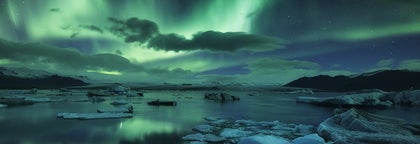
Limited availability
Reserve early to save money
Best price guaranteed
No booking fees
10-Day Untouched Tour | Circle of Iceland with Glacier Hiking & Ice Caving
Come on an adventure of a lifetime and circle the entire island of ice and fire with this 10-day all-encompassing tour. Those looking for an excursion which is packed with unbound nature and wildlife, local history, traditions, and volcanic wonders that will take your breath away, should not miss this tour.
You'll travel from the UNESCO World Heritage site and National Park of Þingvellir, to the beautiful attractions on the South Coast like the waterfalls Seljalandsfoss and Skógafoss, the scenic peninsula Dyrhólaey, and the black sand beach of Reynisfjara.
You will enjoy the epic landscapes of Vatnajökull National Park where you will spend two days exploring the glaciers inside out with a visit to Jökulsárlón glacier lagoon, a glacier hike and an ice cave expedition.
Discover hidden gems as you pass jagged mountain peaks in the Eastfjords of Iceland, on your way to the otherworldly Mývatn area in the North. Spend three days exploring the volcanic wonders of Mývatn, the caldera Krafla, the crater Víti, as well as other secret locations.
In northern Iceland, you'll also see the spectacular waterfall Goðafoss and Vatnsnes peninsula with its untamed seal colonies and the Hvítserkur rock stack that looks magnificent under the Northern Lights.
Before returning to Reykjavík city, you'll stop at Snæfellsnes Peninsula with its diverse terrain of tall, rugged ocean cliffs, volcanos, majestic mountains, and the jewel; Snæfellsjökull glacier.
Sit back and enjoy the ride without a worry. All accommodations on this tour have been sorted out for you, and you'll spend the nights in a comfortable country hotel or guesthouse with a private bathroom and including breakfast. You also have the oppurtunity to go on a glacier hike and a visit to an authentic ice cave.
Don't wait! Discover the wonders of Iceland during the Northern Lights season with the fantastic Untouched 10-day tour. Check availability by choosing a date.
Quick facts
- Available: Jan. - Mar.
- Duration: 10 days
- Activities: Glacier Hiking, Super Jeep, Sightseeing, Northern lights hunting, Hot Spring Bathing, Ice Caving
- Difficulty: Easy
- Minimum age: 6 years.
- Languages: English
- Highlights: Akureyri,
Akureyri, ‘The Capital of the North’ is a town in the fjord Eyjafjörður in North Iceland. It lies just 100 kilometres (62 miles) away from the Arctic Circle. It is Iceland’s second-largest urban area with a population of about 17,800.
Economy
Akureyri is an important fishing centre and port, but in the last few years, tourism, industry, higher education and services have become the fastest growing sectors of the economy.
An airport is located about three kilometres (two miles) from the centre and a large number of cruise ships lay anchor in its busy harbour.
Traditionally Akureyri has survived on fisheries and some of Iceland’s largest fishing companies such as Samherji, have their headquarters there. Other large companies are also based here, such as Vifilfell hf, the largest brewery in Iceland, which produces the famous Kaldi beer.
FSA/Akureyri Hospital is a significant employer in the area and is one of two major hospitals in Iceland.
Akureyri has excellent facilities for travellers and is located a short drive from many of Iceland’s top natural, cultural and historical attractions. Additionally, one of Iceland's best skiing sites is found by Akureyri, at Hlíðarfjall and it is the location for Ak Extreme, an annual skiing and snowboarding festival.
Nature & Landscape
Akureyri is surrounded by mountains, the highest one being Kerling at 1,538 metres (5,064 feet). The area around it has rich agriculture and a beautiful mountain ring.
The island of Hrísey sits in the middle of Eyjafjörður and Grímsey Island, which straddles the Arctic Circle; both islands belong to the municipality of Akureyri. Hrísey is often called 'The Pearl of Eyjafjörður’ and Grímsey 'The Pearl of the Arctic', and these beautiful and peaceful islands are highly popular with travellers.
Both are also home to many puffins.
Furthermore, Akureyri is a very popular place to stay due to its proximity to the Lake Mývatn. This is one of the country’s most popular destinations, due to its incredible natural beauty, intense geothermal activity, a wealth of birdlife and many surrounding sites, including Dettifoss waterfall, the most powerful waterfall in Europe.
It is also close to the seal-watching capital of Iceland, Hvammstangi, on the Vatnsnes Peninsula. This peninsula is also home to the captivating ‘elephant rock’ formation, called Hvítserkur.
The convenience of Akureyri is added to by its position on the Icelandic Ring Road, a route that encircles the country, passing almost every major destination. This means that reaching it from Reykjavík is little trouble, even in winter and the journey takes just under five hours.
History & Culture
During World War II, Akureyri was an essential site for the Allies and the town grew considerably after the war, as people increasingly moved to urban areas.
Akureyri has an active cultural scene, with several bars and renowned restaurants as well as frequent concerts and shows. During the summer there are several notable festivals in Akureyri and its surroundings such as the Vaka Folk festival.
Sites of interest in Akureyri include the brand-new Hof concert hall, many museums and the Christmas house which is open all year round.
The city boasts the world's northernmost botanical gardens which are located close to the swimming pool which is worth a visit.
Akureyrarkirkja church sits in a prized position halfway up the hill upon which most of the city is built. It was completed in 1940 and was designed by one of Iceland's most famous architects, Guðjón Samúelsson, who also was also responsible for arguably Iceland's most famous church, Hallgrímskirkja in Reykjavík.
Jökulsárlón,Jökulsárlón is Iceland’s most famous glacier lagoon. Conveniently located in the southeast by Route 1, about halfway between the Skaftafell Nature Reserve and Höfn, it is a popular stop for those travelling along the South Coast or around the Ring Road of the country.
Geography
As a glacier lagoon, Jökulsárlón is a lake that is filled with the meltwater from an outlet glacier. In this case, it is Breiðamerkurjökull, a tongue of Europe’s largest ice cap, Vatnajökull.
It stands out, however, due to the fact that it also fills with icebergs breaking from the glacier, some of which tower several stories high.
These icebergs, other than their scale, are notable for their colouration. Although they are, as expected, largely white, most are also dyed electric blue in part, with black streaks of ash from eruptions centuries past.
When the icebergs finally make it across the lagoon, they either drift out to sea or wash up on the nearby shore. Because of the way they glisten against the black sands of Breiðamerkursandur, this area has been nicknamed ‘the Diamond Beach’.
In spite of being a rather recent formation, Jökulsárlón is the deepest lake in the country, with depths of 248 metres (814 feet). With a surface area of 18 square kilometres (7 square miles), it is also growing to be one of the largest.
History
Jökulsárlón has not been around since Iceland’s settlement; it only formed around 1935. This was due to rapidly rising temperatures in the country from the turn of the twentieth century; since 1920, Breiðamerkurjökull has been shrinking at a dramatic rate, and the lagoon has begun to fill its space.
Today, the expansion of Jökulsárlón is accelerating. In 1975, it had less than half its current surface area.
In the relatively near future, it is expected that the lagoon will continue to grow until it becomes a large, deep fjord.
Though a dark omen for Iceland’s glaciers and ice caps in general, the retreat of Breiðamerkurjökull has resulted in an incredibly beautiful, if temporary, site. This has not been overlooked by Hollywood.
Jökulsárlón has been featured in the James Bond films A View to Kill in 1985 and Die Another Day in 2002, 2001’s Lara Croft: Tomb Raider, and 2005’s Batman Begins.
In 2017, Jökulsárlón was enveloped into the Vatnajökull National Park, thus it is now fully protected by Icelandic law.
Wildlife
Because of the wealth of herring and capelin that the tides bring into the lagoon, Jökulsárlón is somewhat of a hot-spot for Iceland’s wildlife.
In summer, it is a nesting site for Arctic Terns; stay well away from their nesting area, as these birds are notorious for the fierceness with which they protect their eggs, dive-bombing the heads of any they see as a threat. Skuas also nest on the lake’s shores in this season.
Seals can be reliably spotted here throughout the year, swimming amongst or else hauling out on the icebergs. Jökulsárlón provides them with a safe haven to rest and socialise, especially considering the waters of southeast Iceland are renowned for their population of orcas.
Vatnajökull,Vatnajökull glacier is the largest glacier in Europe, covering 8% of Iceland’s landmass.
It is the central feature of the Vatnajökull National park, found in the south west of Iceland, a popular spot for activities like glacier hiking from Skaftafell, boat tours in the Jökulsárlón glacier lagoon, and ice caving tours between November and March.
Facts about Vatnajokull
Vatnajökull has a surface area of approximately 8,100 square kilometres (3127 square miles); though it is rapidly shrinking due to climate change, its recession is not quite as advanced as at other glaciers, such as Langjökull and Mýrdalsjökull. In parts, it is a kilometre deep (over three thousand feet), and its average thickness is around half of that.
Vatnajökull also holds the tallest peak in Iceland beneath its ice; Hvannadalshnjúkur is 2,200 metres tall (7,218 feet). It also conceals some of the most active volcanoes in the country, the most notable being Grímsvötn, Öræfajökull and Bárðarbunga.
Volcanic activity in the region has occurred on and off throughout the centuries, and many geologists believe that several eruptions are overdue. If their calculations are correct, it would mean significant volcanic activity for Vatnajökull over the scope of the next half-century.
Depending on winds, this could result in worldwide consequences in terms of air-travel, agriculture and the general climate.
The glacier boasts over 30 outlet glaciers, which are channels of ice that flow out of ice caps but remain constrained on the sides of the valley. The major outlet glaciers of Vatnajökull include Dyngjujökull in the north, Breiðamerkurjökull, and Skeiðarárjökull to the south. To the west, one can find the outlet glaciers Síðujökull, Skaftárjökull and Tungnaárjökull.
Numerous rivers run out of Vatnajökull, making up some of the greatest glacial rivers in Iceland. The most notable are:
Tungnaá (west)
Köldukvísl (west)
Þjórsá (west)
Jökulsá á Fjöllum (north)
Skjálfandafljót (north)
Jökulsá á Brú (northeast)
Jökulsá í Fljótsdal (northeast)
Jökulsá í Lóni (south)
Hornafjarðarfljót (south)
Jökulsá á Breiðamerkursandi (south)
Skeiðará (south)
Núpsvötn (south)
Hverfisfljót (south)
Skaftá (south)
Vatnajokull National Park
Vatnajökull National Park was established in June 2008 and has slowly grown to include more and more areas. The park now covers an area of 14,141 square kilometres (5,460 square miles), 14% of the country. It is the second largest national park in Europe.
Rivers divide the highland plateau to the north of the park. The volcanic table mountain Herðubreið towers over this particular region, along with volcanoes Askja, Snæfell and Kverkfjöll.
The canyon Jökulsárgljúfur was carved out by glacial floods centuries ago. At the upper end of the canyon, you'll find Dettifoss, the most powerful waterfall in Europe. Further north, the horseshoe-shaped canyon Ásbyrgi is believed to have formed when Óðinn's eight-legged horse, Sleipnir, stepped his foot down from the heavens.
East around Snæfell, one can find wetlands and ranges, home to roaming herds of wild reindeer and abundant birdlife. Steep mountain ridges make up the south side of Vatnajökull, where outlet glaciers crawl onto the lowlands. The sandy plains of Skeiðarársandur also lie to the south, and the glacial river Skeiðará runs through this vast desert.
One of Iceland's most visited landmarks in the National Park is the Jökulsárlón glacier lagoon, which sits at the base of the outlet glacier Breiðamerkurjökull. Here, large icebergs that have broken off the glacier float across a vast lake before ending up in the Atlantic Ocean, or washed ashore on the nearby Diamond Beach.
This is one of the best seal-watching spots in the country.
The Future of Vatnajokull
The volume of Vatnajökull reached its peak around 1930 but has since been in a steady process of decline. Because of rising levels of global temperature, Vatnajökull has on average lost about a metre (three feet) of its thickness annually over the past 15 years.
If temperature levels continue to rise, the glacier could be all but gone nearing the end of the next century, leaving only small ice caps on top of the highest mountain summits.
Efforts are being made to prevent what some say is the inevitable, with reforestation projects going on all around the glacier, a proven method of cooling the area. Time will tell how successful they are.
Vatnajokull and Jokulsarlon in Popular Culture
The beauty of Vatnajökull National Park has not gone unnoticed by those in film or television. Many famous scenes have been shot here, starting with James Bond: A View to Kill in 1985. Other notable films with scenes here include Batman Begins, Lara Croft: Tomb Raider, and James Bond: Die Another Day.
Most famously, however, many places in Vatnajökull have been used in the HBO Series Game of Thrones, north of the Wall. The Wall itself is constructed with CGI using shots of the glacier.
Mývatn,Mývatn is a beautiful lake with many small islands in the north of Iceland, the fourth largest lake in the country. Due to its serenity, birdlife and volcanism, the lake, including its surrounding area, is one of the most amazing natural attractions in the country.
Mývatn is, in fact, so beautiful that is was used as a site in the Game of Thrones franchise. In mid-winter it was used to represent the lands North of the Wall, namely Mance Raider’s Wildling camp.
Geology
Mývatn sits about an incredibly active geothermal area, giving it a unique and beautiful geology. After all, it is close to sites such as Krafla caldera, which contains the notorious Víti volcano, the name of which translates to ‘hell’.
Many of the islands here are thus pseudocraters, formed by steam explosions as magma rose beneath pockets of water, and many are bizarre basalt columns, rising vertically from the surface, formed by rapid cooling after an eruption.
The high amount of geothermal activity beneath Mývatn, of course, presents the opportunity for bathing in naturally heated waters. This is best done at the Mývatn Nature Baths, a beautiful establishment with serene waters, incredible views, and a reasonable entry fee.
Wildlife
Mývatn has some of the best bird-watching available in Iceland, although those seeking puffins will need to be at coastal cliffs such as those at Látrabjarg and Dyrhólaey, between May and September.
In fact, Mývatn has more species of duck than anywhere else in the world, with thirteen nesting species and many more visitors. Most popular (and common) amongst these is the harlequin duck sometimes referred to as the white-eyed diver after their unique white markings.
Mývatn’s surrounding vegetation and plentiful food make it a happy home for voles, mice and rats that have spread all over Iceland, providing tasty treats for Iceland’s only native land mammal, the Arctic Fox. Visitors, however, will have to keep a close eye out for these, as they are experts in camouflage.
In terms of flora, the most interesting plant life at Mývatn actually exists just beneath the surface of the water. Marimo are ‘moss balls’, bizarre spheres of fluffy green algae that are found in very few other places around the world, namely Japan (where they got their name), Scotland, Estonia and Australia.
Surrounding sites
Visitors to Mývatn often wish to spend more than just a single day exploring its many surrounding locations. Primary amongst these is Dimmuborgir, a lava field which truly reflects the dramatic consequences of a volcanism in Iceland. This area is steeped in folklore and is home to the thirteen ‘Santas’ of Iceland, the Yule Lads.
It was also here that many of the Game of Thrones scenes were shot such as Mance Rayder's wildling camp at Dimmuborgir and Grjótagjá cave, where Jon and Ygritte shared an evening together. Though this site can be admired from the shore, the water temperature is not monitored and can heat up very quickly, so visitors are asked not to take a dip.
Those with an interest in Iceland’s strange geothermal and geological sites should also check out the Skútustadagígar pseudo-craters and the aforementioned Víti crater and its surrounding lava field. There are also several geothermal hot spots around Krafla and the Námaskarð Pass which is a fascinating and primordial place.
Lake Mývatn is located on the Ring Road that fully encircles the country, making further sites easily reachable. To the west is the ‘Capital of the North’, Akureyri, a charming town with the highest population outside of the capital area.
To the east, you can find the largest waterfall in Iceland, Dettifoss which also happens to be the most powerful waterfall in Europe, and the incredible horseshoe-shaped canyon, Ásbyrgi. This feature was said to have formed by the stomping of one of the feet of Oðinn’s eight-legged horse as it leapt through the sky.
Dimmuborgir,Dimmuborgir, or the Black Fortress, is a dramatic expanse of lava in the Lake Mývatn area. Steeped with folklore, it is one of the most popular destinations for travellers to north Iceland.
Geology of Dimmuborgir
Dimmuborgir was formed in an eruption that occurred in the area 2,300 years ago; the Lake Mývatn area is highly volcanic, as can be further seen in nearby locations such as the geothermal Námaskarð Pass, the hot spring cave Grjótagjá, and the dramatic Krafla fissure.
As lava flowed across the area, it passed over a lake, causing it to boil. This both quickened the cooling of the lava and caused pillars of steam to shatter parts of it. After it solidified, Dimmuborgir area became defined by large stacks of rock and many caves and caverns, caused by bubbles of intense steam.
As such, many have compared Dimmuborgir to a medieval castle, with its many hidden chambers and its rising towers.
Folklore of Dimmuborgir
In Icelandic culture, lava caves are allegedly the homes of the nation’s brutal and vile trolls. The most famous of these were the half-troll, half-ogre Grýla and her submissive husband Leppalúði. Grýla was renowned for her insatiable appetite for children, and her gigantic pet cat, that would eat children over the Christmas period for not getting any clothes (encouraging kids to finish their weaving, knitting and sewing chores before the season set in).
Grýla and Leppalúði had thirteen sons who lived in Dimmuborgir and are now known as the ‘Icelandic Santa Clauses’ or Yule Lads. On the thirteen nights before Christmas, these trolls come one by one to terrorise Icelanders, each with their own strategy after which they were named.
Sheep-Colt Clod, for example, would harass livestock; Skyr-Gobbler would steal and lick the house's supplies of yoghurt-like skyr; and Window-Peeper would stare into houses, looking for things to burgle.
Like most frightening Icelandic stories, the Yule Lads were most likely created to keep children from going out into the cold Icelandic winter nights, where many disappeared without a trace for centuries. As the nation modernised, they became mischievous tricksters rather than devilish monsters. Now, they have been ‘Americanised’; rather than traditional Icelandic garb, they wear Santa costumes, and although they still steal skyr, they now also bring gifts.
Due to Iceland’s remoteness and fondness for storytelling, the nation developed many unusual Christmas traditions.
During the Christianisation of Iceland, Dimmuborgir developed a new set of tales. Many began to believe, due to its starkness, that it was where Satan landed when cast from heaven, and where he created the catacombs to hell.
Dimmuborgir in pop culture
Dimmuborgir recently saw a surge in popularity, as it was featured on HBO’s Game of Thrones. In the series, it is where Mance Raider held his wildling army. It was shot here in winter.
The popular Norwegian black metal band Dimmu Borgir is also named after the area.
Vatnsnes,Vatnsnes is a peninsula in north Iceland, best known for its wildlife and geology.
Wildlife at the Vatnsnes Peninsula.
The Vatnsnes Peninsula is well-known as being one of the best places in the country, alongside the Westfjords, Ytri Tunga Beach and the Jökulsárlón glacier lagoon, to watch seals from the shore.
Iceland is home to grey and harbour seals throughout the year, although occasionally is visited by harp, ringed, hooded and bearded seals. Rogue walruses even show up on rare occasions, but not as far south as Vatnsnes.
The best locations on the Vatnsnes Peninsula to see seal colonies are at the farms Svalbarð and Illugarstaðir. Both of these have car parks and signposts to assist visitors in getting close to the seals, and neither require a great deal of walking to reach the optimal viewing points. At Illugarstaðir, there are also bathroom facilities and binoculars available.
The best time to view the seals is the two hours before and after low tide, when the weather is clear.
The seals of these sanctuaries are not particularly afraid of people, but even so, they are wild animals and should not be approached, and definitely not fed; though usually peaceful, seals have been known to bite, and such wounds are very easily infected.
It is also essential that, in spite of videos on Youtube, the seals should never be filmed with a drone. They are very sensitive to noise, so the buzzing sound (as well as any shouting) will frighten them away, disturbing the animals and ruining the experience for all other guests.
To learn more about the seals on Vatnsnes, visitors should attend the Icelandic Seal Centre, located in the largest town on the peninsula, Hvammstangi.
The centre has been running since 2005, and has exhibitions on the biology and geographical distribution of seals, the protection of seals, and the relationship between the animals and man since settlement. It also has information on the birds and whales that frequent the Vatnsnes Peninsula.
To learn more about seal-watching in Iceland, there is a relevant article you can read on this site.
Geology of the Vatnsnes Peninsula
Vatnsnes is a mountainous peninsula that is geologically less active than the rest of the country. It still has interesting basalt formations, however, the most notable of which is the Hvítserkur monolith.
This bizarre feature stands just out to sea in shallow water, and is most often compared to an elephant drinking; some onlookers have said it more resembles a dragon or a dinosaur.
According to legend, however, it is a troll, that waded into the sea to throw rocks at the nearby monastery (trolls, unlike hidden elves, despised Christianity, and could not live on or near sanctified ground). It is said that the sun rose during its assault and it had no time to find shelter; it was frozen into the rock formation you see today.
Hvítserkur has been reinforced at its base with concrete to preserve it for future generations. It is one of the country’s most photographed landmarks, both for its unusual shape and the fact it hosts many nesting birds in summer, who can lay their eggs safe from land predators such as Arctic Foxes and rats.
Goðafoss,Goðafoss waterfall is located in the river Skjálfandafljót in north Iceland, the fourth largest river in Iceland. It is one of the most spectacular waterfalls in the country, falling from a height of 12 metres (39 feet) over a width of 30 metres (98 feet).
History of Goðafoss
The name Goðafoss means either waterfall of the gods or waterfall of the 'goði' (i.e. priest/ chieftain). The reason for this is its fascinating history.
When Iceland was first settled in the 9th and 10th Centuries, the vast majority (who were not slaves, at least) were Norwegians who followed the Old Norse religion, worshipping deities like Thor, Odin, Loki and Freya. However, after the Commonwealth was established in 930 AD, pressure to convert began to push from Christianising Europe.
By 1000 AD, it seemed that Norway would almost certainly invade if the country were to stand by their pagan beliefs. The issue was thus discussed at Þingvellir, where the parliament met once a year. The lawspeaker at the time, the Ásatrú priest (or goði) Þorgeir Ljósvetningagoði, was given the responsibility to make the decision.
It is said he sat beneath a birch for a day and a night in silence, praying to his Old Gods for the right decision. Eventually, he emerged and said, for the good of the people, Christianity would be the official religion, but pagans could practice in private.
To symbolise his decision, he returned to his home in north Iceland and threw idols of the Old Gods into a beautiful waterfall. Since then, it would be known as Goðafoss.
Getting to Goðafoss
Goðafoss is located in north Iceland, on the Ring Road that fully encircles the country. It is considered part of the Diamond Circle sightseeing route.
This trail also takes visitors to the Lake Mývatn area, Dettifoss Waterfall, Ásbyrgi Canyon and the town of Húsavík.
Mývatn is a beautiful lake, filled with a wealth of birdlife, and it is renowned for it incredible surroundings, which include fortresses and of lava, geothermal areas, craters and basalt pillars. Dettifoss is another waterfall, and though it does not have the history of Goðafoss, it has much more power; it is, in fact, the most powerful waterfall in Europe.
Ásbyrgi Canyon, meanwhile, is also linked to the Old Norse Gods. Its perfect horseshoe shape was said to have been created by the stomping of one of the hoofs of the eight-legged steed of Odin. The final destination on the Diamond Circle is Húsavík, the best place for whale-watching in Iceland.
Outside of the Diamond Circle, Goðafoss, is easily reached by travelling for 45 minutes east by car from the capital of the north, Akureyri.
This is the largest settlement outside of the Greater Reykjavík Area and is a perfect place to stay for those travelling the circle around the country. It is a renowned cultural centre, with many museums, galleries and the world’s northernmost botanical gardens. Many tours depart from here.
Goðafoss can be reached throughout the year, although drivers in winter will want to be sure that they rent a four-wheel-drive vehicle.
Dettifoss,Dettifoss is a waterfall found in North Iceland, said to be the most powerful in Europe. It is regularly visited on Diamond Circle tours and should not be missed by any visiting the region.
Geography
Dettifoss is fed by the powerful glacier river Jökulsá á Fjöllum which flows from the largest glacier in Europe, Vatnajökull. The thunderous falls has an average waterflow of 193 metres cubed per second (6,186 cubic feet). It is 100 metres (330 feet) wide and plummets 45 metres (150 feet) down into Jökulsárgljúfur canyon.
This canyon is in the northern part of the greater Vatnajökull National Park, the largest national park in the country, thus Dettifoss is well protected.
Also within this canyon, fed by the river of Jökulsá á Fjöllum, are two more impressive waterfalls, Selfoss (not to be mistaken with the southern town of the same name) and Hafragilsfoss.
Surrounding Sites
Dettifoss is located north of the Ring Road that encircles Iceland, bypassing only the Westfjords and Snæfellsnes Peninsula in the west. There are two routes that connect the Ring Road to Dettifoss. However, traversing those in the winter can be difficult, even with a four-wheel-drive vehicle.
The most significant settlement near Dettifoss is the town of Akureyri, or ‘the Capital of the North’. With over ten thousand people, it is the largest town outside of the Greater Reykjavík Area. It is an excellent place to stop and rest for those visiting the North or encircling Iceland.
Another town of significance in the area is Húsavík, a coastal town that claims the title of the best whale watching town in all of Europe. In summer, operators usually have 100% success rates in terms of sightings. The most common species are humpback and minke whales, white-beaked dolphins and harbour porpoises, although blue, fin, sei, beaked, pilot, beluga and killer whales are seen on rare occasions.
Between Akureyri and Dettifoss is the Lake Mývatn area. This beautiful expanse is renowned for its wealth of flora and fauna, particularly its birdlife; dozens of species can be found here, particularly ducks.
It is also renowned for its spectacular geology, with its pseudocraters, basalt pillars, and the lava field of Dimmuborgir which is said to be the home of Iceland’s thirteen ‘Santas’, who are traditionally vindictive trolls more than they are jolly gift-givers.
Dimmuborgir and Mývatn were both used as a set in the Game of Thrones franchise, for many scenes North of the Wall. Dettifoss, meanwhile, was used in the opening scene of the 2012 film Prometheus, where the black rocks and dramatic scenery allowed it to represent an alien landscape.
Another waterfall sits on the Ring Road between Akureyri and Mývatn: Goðafoss. Though not as great as Dettifoss, its history is deeper; it was there in 1000 AD that Iceland’s lawspeaker symbolised the country’s shift from believing in the Old Norse Gods to believing in Christianity by throwing idols into the waterfall.
North of Dettifoss, one can find the incredible canyon of Ásbyrgi. This canyon is shaped like a giant horseshoe and filled with verdant greenery. It is so perfectly formed and dramatic that it was originally believed to have been created by the stomping of one of the hoofs of the eight-legged horse of the Old Norse God Odin.
Snæfellsjökull,Snæfellsjökull is a glacier-capped volcano found on the tip of the Snæfellsnes Peninsula in west Iceland. It stands in a National Park of the same name, one of the only three National Parks in the country.
It stands at 1,446 metres (4,744 feet) tall, and on clear days, is visible across the bay from Reykjavík. The stratovolcano beneath Snæfellsjökull is 700,000-year-old.
The mountain is actually called 'Snæfell' (Snowy Mountain), though the 'jökull' (Glacier) is often added to help distinguish it from other mountains of the same name.
For the first time in recorded history, Snæfellsjökull had no snow or ice at its peak in August 2012, causing concern amongst locals that climate change is threatening the nature of the mountain.
History
Snæfellsjökull has several small villages surrounding it, including Hellissandur, Rif and Ólafsvík, all of which were some of the busiest commercial and fishing hubs in the country for much of the last millennium.
Fishing took off primarily in the 13th-Century, with fishing stations being built in all areas with easy access to the open ocean. The Snæfellsnes Peninsula was a notable centre of this industry, due to the fertile waters within Breiðafjörður bay.
One notable example would be the settlement of Dritvík; in spite of its minuscule size today, it once utilised around forty to sixty boats and employed up to six hundred people.
Fishing in the region declined during the 19th century due to change in Iceland’s industry and fish stocks, though it is still an important source of livelihood for those living on the Peninsula.
The Snæfellsjökull National Park was established in 2001, and tourism is rapidly changing the trade of the area.
In Folklore
Snæfellsjökull has, for centuries, been considered to be one of the world’s ancient power sites, a source of mysticism, energy and mystery for the peninsula’s superstitious population.
The feature takes a prominent role in Bárðar saga Snæfellsáss, a late 14th-century saga that tells the story of Bárður, half-human-half-troll, who became the 'guardian spirit of Snæfellsjökull'.
There are many rock formations on and around Snæfellsjökull that are said to be trolls petrified by sunlight, or else homes of the hidden people.
On November 5th, 1993, thousands of people came to Snæfellsjökull as some paranormal enthusiasts believed there would be an alien landing; CNN even showed up with a camera crew. Though the evening passed without a galactic invasion, the incident shows the strange significance of Snæfellsjökull to many.
In Literature
Snæfellsjökull serves as the entrance to a fantastical subterranean world in Jules Verne’s classic 1864 novel 'Journey to The Centre of The Earth.' Given its central place in the novel, Snæfellsjökull has become one of the most popular spots for visitors in Iceland and has inspired a wealth of writers, poets and artists.
Since 'Journey to The Centre of The Earth', Snæfellsjökull has appeared in the ‘Blind Birds’ trilogy by Czech science fiction writer Ludvík Souček (partially based on Jules’ work) and in ‘Under The Glacier’, a novel by Iceland’s only Nobel laureate, Halldór Laxness.
Nearby Attractions
Along with the glacier, attractions on the Snæfellsnes Peninsula include the two nearby basalt cliffs called Lóndrangar and the many fascinating lava formations at the beautiful Djúpalónssandur beach, such as the arch rock Gatklettur.
At Djúpalónssandur, one can also test their muscle as historic sailors once did with the four 'strength' stones, Amlóði ('Useless'), Hálfdrættingur ('Weakling'), Hálfsterkur ('Half Strength') and Fullsterkur ('Full Strength').
In the area, one can also explore the Saxhóll volcano crater and 'the singing cave' Sönghellir, which is named after the loud echoes inside.
Skógafoss,Skógafoss is one of Iceland’s biggest and most beautiful waterfalls with an astounding width of 25 meters (82 feet) and a drop of 60 meters (197 feet).
Due to the amount of spray the cascade produces, at least one rainbow is present any time the sun emerges from behind the clouds.
Located on the Skógá river, this mighty cascade is clearly visible from Route 1 and is an excellent place to stop and stretch the legs while travelling Iceland’s South Coast. The river below Skógafoss holds a large char and salmon population and is thus a favourite spot for fishermen in the summer.
The land underneath the waterfall is very flat, allowing visitors to walk right up to the wall of water. This will get you drenched, although, on a summer’s day, it can be quite tempting.
Skógafoss can also be viewed from the top as a steep staircase leads to an observational platform above the cascade. Many nesting seabirds can be found on the route up.
Geography
Skógafoss is located near the small village of Skógar, south of the Eyjafjallajökull glacier volcano. There you’ll find the Skógasafn folk museum, an open-air museum with both old wooden houses and turf houses, as well as a regional museum with various artefacts from this area.
A part of the Skógasafn Regional Museum is the Museum of Transportation, which showcases the history and evolution of transportation, communication and technologies in Iceland. There, you can see how this nation evolved from the age of the working horse to the digital communications of the 21st century.
The Skógasafn museum also includes a café and a museum shop, and in the village of Skógar, you will find both a hotel and a restaurant.
At the eastern side of Skógafoss, you will find one of Iceland’s most famed hiking routes; the Fimmvörðuháls pass. The 22 kilometre (14 miles) trail takes you along Skógá river, between two glaciers, Mýrdalsjökull and Eyjafjallajökull, before ending in the beautiful Þórsmörk valley.
Skógafoss is often visited alongside the waterfall Seljalandsfoss, which is just a little further along the South Coast. Both fall from cliffs of the same height, and while Skógafoss is much more powerful, Seljalandsfoss has a cave behind it, which means it can be fully encircled. It is also next to a much lesser known but still awe-inspiring waterfall, Gljúfrabúi.
Folklore
A gold ring is on display at the Skógasafn museum. According to legend, the ring is from a chest that was owned by Þrasi Þórólfsson, one of the first Viking settlers in the area, who by some accounts was a giant. Folklore states that before his death in 900 AD, Þrasi buried a chest filled with gold in a cave behind Skógafoss waterfall.
Many attempts were made to retrieve the chest after Þrasi’s death, and years later, locals managed to grasp a ring on the side of the chest. As they pulled, the ring broke off, and the treasure was lost forever. The ring was then given to the local church before it made its way to the museum.
Seljalandsfoss,Seljalandsfoss is a waterfall that can be fully encircled, situated on the South Coast of Iceland with a drop of 60 metres (200 feet).
Due to the waterfall’s close proximity to the Ring Road and impressive natural features, it is one the country's most famous and visited falls. Majestic and picturesque, it is one of the most photographed features in all of Iceland.
Geology and Surroundings
Seljalandsfoss waterfall, part of the river Seljalandsá, has its origins underneath the glacier Eyjafjallajökull. The volcano beneath this ice cap was the one that erupted in 2010 and caused havoc at airports across Europe.
The cascade of the falls is relatively narrow but falls from a tall cliff that once marked the country's coastline, the sea is now located across a stretch of lowlands and is visible from the site.
The most distinguishing feature of Seljalandsfoss is a pathway that stretches all the way around it. The cliffs behind the falls have a wide cavern, and rocks and paths allow guests to fully encircle it in summer.
Though a mesmerising opportunity, visitors should be prepared to get dampened due to the perpetual mist of the falls, which also tends to make the rocks of the pathway slippery.
Floodlights have been set up on both sides of the waterfall, which impressively illuminate the scene during the night when the midnight sun is not out. The lights were installed in 2001 due to the growing popularity of the falls as a tourist destination.
After visiting Seljalandsfoss, it is common for visitors to continue north to the waterfall Gljúfrabúi, which is found partially hidden behind a rock face. Because of Seljalandsfoss extreme popularity, Gljúfrabúi is widely considered the hidden gem of the scene, as it is too often overlooked.
Seljalandsfoss is also usually visited alongside the nearby Skógafoss. The waterfall falls from the same height, and while it cannot be encircled, it is much more powerful and steeped in the legend of a giant’s hidden treasure.
Visitor Centre Controversy
In 2017, it was announced that a visitor’s centre was to be constructed near the falls. The design of the building indicated that it would be seven metres (23 feet) high and 2,000 square metres (21,500 square feet) in size. Landowners in the area opposed to the idea, proclaiming that the centre would greatly alter the natural appearance of the waterfall’s renowned scenery.
The project has neither been fully approved nor wholly cancelled, with ideas surfacing of either significantly reducing the size of the construction, or moving the visitor centre’s location further away, for instance to the nearby farmstead Brekkuhorn.
Seljalandsfoss in Popular Culture
Along with a multitude of South Iceland’s most famous natural attractions, Seljalandsfoss can be seen in Justin Bieber’s music video for his song ‘I’ll Show You’. Please enjoy the video without emulating any antics that will endanger yourself or the environment.
The waterfall was also a featured waypoint during the first leg of the sixth season of The Amazing Race, an American reality TV series.
Hekla,Hekla, nicknamed ‘the Gateway to Hell’ in the Middle Ages, is one of Iceland’s most explosive, unpredictable and powerful volcanoes. It has erupted twenty to thirty times since settlement, and remains active to this day.
Geography of Hekla
Hekla is located in the south of Iceland, just north of the country’s most famous volcano, Eyjafjallajökull, which last erupted in 2010, causing planes to be grounded and reporters to be tongue-tied for weeks. A dominant peak, standing at 1,491 metres tall (4,892 feet), it can be seen for miles around.
Hekla is part of a 40 kilometre (25 mile) rift, the most active part, called Heklugjá, being under the volcano itself. There are many craters at the peak, two of which are known to erupt more than the others.
Unlike Eyjafjallajökull and Iceland’s other most active volcano, Katla, Hekla does not sit underneath any significant glacier, meaning its eruptions should not cause ash clouds to the same degree. In spite of this, some have been so great that the ash produced was still enough to change the climate of the northern hemisphere for years.
Hekla has also produced one of the greatest lava flows of this millenium of any volcano in the world, at eight cubic kilometres. Approximately 10 percent of Iceland’s landmass was brought up by lava from Hekla.
History of Hekla
The first recorded eruption at Hekla was in 1104, and it was so great and significant that it drew attention across Europe; the effects it had on the weather, on people’s breathing, and on agriculture lasted for years.
This, however, was not the first time it had done so; undiscovered by man, it had contributed to a third of all volcanic ash across northern Europe for the past seven millenia.
It would not significantly erupt again until 1300, although it had been recorded going off several times in between; one of the most notorious things about Hekla is its unpredictability, sometimes exploding within a decade of its last eruption, sometimes laying dormant for nearly a century.
For this reason, the farms around it were largely abandoned, partly explaining why today there are few settlements in Iceland’s south.
Further serious eruptions occurred in 1693 and 1845 with international consequences, but none as significant as the one that began in 1947. Lava bombs weighing over 20 kilograms (44 pounds) landed 32 kilometres away; some as large as 50 square metres (538 square feet) were thrown a kilometre. It took just 52 two hours before the enormous cloud of ash was covering Helsinki.
It would be thirteen months before the eruption stopped, ebbing and flowing with power, but constantly pouring ash into the atmosphere, poisoning crops and livestock.
It is likely many died of respiratory problems as a result, but Hekla even directly killed one person. A scientist filming the great lava flows from the crater, some of which were 15 metres (49 feet) tall, was struck by a block of lava.
Hekla erupted again in 1970 for two months, but since has only gone off for a few days at a time, in 1981, 1982, 1991 and 2000.
Though the 2000 one seemed inconsequential, it was later discovered that it proved that Hekla was even more frightening than was already thought. The remains of a pyroclastic flow, the most dangerous element of an eruption, where searing ash and rock travel at enormous speeds and raze all they meet, had occured for over five kilometres (three miles).
Hekla today
In spite of its volatile nature, Hekla can still be considered a safe place to visit; there are hiking opportunities all around it, and some tour operators embark in super jeeps journeys to its slopes. Visitors should not be afraid of the volcano’s potential, just aware of it.
Of course, before heading to Hekla if travelling without a guide, ensure you check the meteorological office’s website to ensure that there are no alerts that an eruption may be imminent. The volcano is monitored constantly.
In spite of this, Hekla remains as unpredictable as it ever was, and visitors are warned that in spite of every good measure, there is always a chance an eruption could start without being noticed.
Volcanologists also warn that it is overdue, and due to this volcano’s patterns, the warning time between knowing an eruption is imminent and it occurring will often be just an hour or less.
Eyjafjallajökull,The glacier volcano of Eyjafjallajökull is notorious the world over for causing havoc to air travel in 2010, and stumping television anchors everywhere as they tried to pronounce it. 1651 metres (5427 feet) tall, it is one of the most dominant features of the South Coast.
Geography
The glacier of Eyjafjallajökull is approximately 100 square kilometres (39 square miles), making it the country’s sixth largest. It sits close to the fourth greatest, Mýrdalsjökull, which also conceals another notorious volcano, this one called Katla.
While Eyjafjallajökull’s eruption was huge and disruptive, it pales in comparison to the potential of Katla. Far more explosive, and under much thicker ice, an eruption here in unfavourable wind conditions could have worldwide consequences.
The magma chambers between both of these mighty volcanoes are connected, and, unfortunately for us, an eruption at Eyjafjallajökull is usually followed by one at Katla within a decade.
Eyjafjallajökull has many glacial outlets, the most famous being Gígjökull. Many rivers flow from its meltwater, and one of these falls into the beautiful South Coast waterfall, Seljalandsfoss, which it is possible to fully encircle.
Eruptions
Eyjafjallajökull’s most recent eruption was no doubt the most famous in Iceland’s history (although the honour really should go to Laki, the 1783-4 eruption of which caused an ash cloud so great that Europe fell into a famine that many historians believe led to the French Revolution). On March 27th, 2010, magma began to bubble from beneath the surface, and by April 14th, ash was starting to billow from the peak.
800 people were evacuated, in fears not of magma, but of equally dangerous glacial floods, which have decimated Icelandic towns in the past. Animals were ordered to be kept inside, and those with respiratory problems told they should also stay indoors.
Air travel across Europe was halted, as, by the evening of April 15th, the ash was already over the UK, Scandinavia, and parts of Germany. Holidaymakers were trapped, waiting for news, and would end up stuck for eight days; in Scotland and Ireland, there were even flights delayed in May due to lingering effects.
Thankfully, no one was injured, although the ash is thought to have caused respiratory issues for some in the south of the country. Many farms were also destroyed by the ash and floods, with some farmers still struggling to recover today.
Since settlement in 874, Eyjafjallajökull has also erupted in 900, 1612, and from 1821 to 1823. The latter released a huge amount of fluoride which is believed to have affected the bone health of humans and animals alike at the time.
Eyjafjallajokull today
Eyjafjallajökull is now entirely safe to visit and is seen on most tours of the South Coast in clear weather. In the town of Hvolsvöllur, there is a visitor’s centre on the volcano, which focuses on the experience of one family whose farm, Þorvaldseyri, was one of the many destroyed by the floods, lava and ash.
It is very unlikely that Eyjafjallajökull will erupt again any time soon, with hundreds of years between each eruption, but as mentioned, its neighbour Katla might start rumbling...
Dyrhólaey,Dyrhólaey Peninsula is a 120-metre promenade famed for its staggering views of Iceland’s South Coast, as well as its historic lighthouse and wealth of birdlife. It is home to a rock arch of the same name.
Dyrhólaey, which translates to Door Hill Island, is of volcanic origin and was once an island before joining up to the Icelandic mainland. In ancient times, passing sailors used to refer to Dyrhólaey as ‘Cape Portland’.
It is also the southernmost part of the Icelandic mainland, making it a popular stop for sightseers travelling along the Ring Road, and can be found close by the coastal village of Vík í Mýrdal.
Other features along the South Coast en route to Dyrhólaey from Reykjavík include the waterfalls Seljalandsfoss and Skógafoss, and the glacier Eyjafjallajökull.
Dyrhólaey Arch
Dyrhólaey’s most instantly recognisable attraction is the promenade’s massive rock arch, a result of centuries of erosion. As a result, its name is in direct reference to this enormous arch. In fact, this natural feature is so large and dramatic that one daredevil pilot even flew through it, back in 1993. Boats can easily cruise through its opening.
Dyrhólaey Wildlife
Dyrhólaey has an abundance of birdlife, the most common year-round being Eider Ducks. Iceland’s favourite winged resident, the migratory Atlantic Puffin, can be found here from May to September.
It is one of the best places to reliably locate them, and one of the closest to Reykjavík after the islands in Faxaflói Bay which can be visited by boat from the Old Harbour.
While watching puffins, it is striking how little they seem to fear people, as they allow you to get very close. Be aware, however, they do not like to be touched, and if one flies off in a panic, the whole flock might follow it, so be respectful.
Features at and around Dyrhólaey
From your position atop the promenade of Dyrhólaey, you can enjoy staggering views over Iceland’s black sand beaches, complemented by the glittering waves of the Atlantic on one side, and distant mountainscapes to the other.
The most notable stretch of coast here is called Reynisfjara, renowned for its incredible geology, with the sea-stacks of Reynisdrangar jutting up out to sea. If you visit this beach while seeing Dyrhólaey as part of a South Coast adventure, be sure to follow the warning signs and stay away from the water as dangerous sneaker waves here are commonplace.
To the north, you will also able to see the creeping glacier, Mýrdalsjökull. This amazing ice cap conceals a secret; beneath its surface is one of the most explosive and notorious volcanoes in all of Iceland, Katla. Long overdue, experts say that it is a matter of when - not if - it will erupt over the coming years.
On top of Dyrhólaey stands Dyrhólaeyjarviti, a beautiful old lighthouse that consists of a white, square concrete tower. The first lighthouse in the area was built in 1919; the current construction was completed in 1927. Visitors here will be able to see the lighthouse flicking out beams of white light to sea every ten seconds.
Þingvellir,Þingvellir National Park is the only UNESCO World Heritage site on the Icelandic mainland and one of the three stops on the world famous Golden Circle sightseeing route, alongside the Haukadalur Geothermal Valley (Geysir) and Gullfoss Waterfall. Just to the south of the park is Þingvallavatn, Iceland’s largest natural lake.
Geography
The first thing that visitors to the National Park notice is its sheer aesthetic beauty; dried magma fields, covered in Icelandic moss, sit carved by glacial springs and surrounded by a bowl of ancient mountain peaks.
Two of the greatest attractions in the park are the exposed North American and Eurasian tectonic plates; it is one of the only regions in the world where you can see geology such as this on land.
Visitors are encouraged to walk along the North American tectonic plate, where they can read more about the area’s fascinating formation and history, before descending into the valley below.
History
Þingvellir can be anglicised to ‘Fields of Parliament’, a nod to the area’s fascinating history and relevance to Icelandic culture. It is here, after all, that the world’s first democratically elected parliament that remains functioning, Alþingi, was formed in 930 AD.
It may seem unlikely that Vikings would want to be under such an uncombative government, but the thirty or so clans that lived in Iceland at the time sought to prosper in their harsh new environment.
The first gathering was such a success that the meetings became annual, and it became a place where disputes were settled, criminals were tried, and laws to the benefit of all were laid down.
This saw the birth of the Icelandic Commonwealth, a time of independence and freedom for the Icelandic people before they became constituents of the Norwegian monarchy. Sessions would continue to be held at Þingvellir until 1798.
Though the parliament was removed by the Danish at this time, it returned 1845 to Reykjavík.
Another major reason as to why Þingvellir is considered so important to Icelanders is the fact that this is where the decision was made to abandon the belief of Paganism and the Norse Gods; the people adopted Christianity in 1000 AD under threat of invasion from Norway.
This turning point in history was left to the pagan lawspeaker, Þorgeir Þorkelsson, who rested on the choice for one day and one night before reappearing to share his decision.
To symbolise the country’s change, he threw idols of his old deities into the northern waterfall Goðafoss, the name of which translates to ‘Waterfall of the Gods’.
Silfra Fissure
Þingvellir is one of the most widely visited attractions in Iceland, in large part due to the fact that it is home to the glacial spring, Silfra fissure, one of the top ten sites in the world for snorkellers and scuba divers.
Silfra (meaning ‘Silver’) is a submerged ravine within the park, boasting visibility of up to 100 metres (328 feet) and a temperature just above freezing. Participants in these tours will be attired at the Silfra carpark in neoprene hoodies and gloves, as well as an undersuit and drysuit for thermal protection.
Snæfellsnes,Snæfellsnes is a large peninsula extending from West Iceland, often nicknamed ‘Iceland in Miniature’ due to its wealth and diversity of natural features found there.
Home to the Snæfellsjökull National Park, at the centre of which is a subglacial volcano that towers over the scenery, this peninsula is home to waterfalls, rock formations, beautiful beaches, historic villages, and an intricate folklore.
In particularly clear weather, the Snæfellsnes Peninsula can sometimes be seen from Reykjavík, making views across the water from the capital of Iceland particularly beautiful. Those with an extended stay in Iceland are recommended to look into spending at least a day here.
Natural Sites of Snaefellsnes
The peninsula stretches 90 kilometres (56 miles) from West Iceland, between the Reykjanes Peninsula to the south and Westfjords to the north. A mountain range runs along it, consisting of both active and dormant volcanoes, culminating at the magnificent, ice-capped Snæfellsjökull volcano.
Starting along the south side of the Snæfellsnes Peninsula, you will first come to the Eldborg crater, which can be scaled for some incredible views, and the Gerðuberg basalt cliffs, where hundreds of hexagonal basalt columns are arranged with geometric precision. You will then start hugging the coast, where animal-lovers can find the Ytri-Tunga beach and its year-round seal colony.
The next site of particular natural beauty is the Rauðfeldsgjá Gorge, a cleft in a huge cliff face that it is possible to climb into. A stream runs through here, so those who want to plumb its depths will get wet. Those with decent clothing, sturdy shoes and reasonable fitness, however, will be able to get quite far.
After Rauðfeldsgjá, you will come to the mighty basalt plugs of Lóndrangar. All that remains of what was once a massive crater, these two enormous pillars are not only awe-inspiring in their scale, but home to thousands of nesting seabirds.
You will then enter Snæfellsjökull National Park, which, in spite of being the smallest of the country’s three national parks, is pregnant with destinations worth visiting.
The most historic of these is Djúpalónssandur beach. Comprised of black, volcanic sands, it is best-known for the four lifting stones that remain on the beach from a bygone age. Fishermen would use these stones to mark their strength, and gage their suitability to working on the dangerous waves.
Within the National Park are also two lava caves that can be entered in summer. Sönghellir is renowned for the musical qualities of its echoes, whereas Vatnshellir is favoured for its easy access and vivid colouration. There is a small entry fee to the latter and you cannot enter it without a guide.
Of course, however, the highlight of this part of the Peninsula is no doubt Snæfellsjökull itself. Even if you are not ascending it on a glacier hiking tour, it is worth stopping by to marvel at.
This is particularly the case for literature enthusiasts. The adventure in the Jules Verne novel ‘A Journey to the Centre of the Earth’ begins here, and it is the backdrop to the lesser-known novel ‘Under the Glacier’, by Nobel-Prize winning Icelander, Halldór Laxness.
On the north side of the peninsula is the haunting Berserkjahraun lava field, near the town of Bjarnarhöfn, the history of which weaves deception and murder. Most notable on this stretch, however, is the mountain Kirkjufell, often described as the most photographed mountain in Iceland, and known as "the mountain shaped like an arrowhead" from the popular HBO series, Game of Thrones.
Cultural Sites of Snaefellsnes
There are a few small and beautiful villages dotted across the peninsula, the majority of which are on the northern side, where the fishing is better. Most notable are Arnarstapi, Hellnar, Búðir, Hellissandur, Ólafsvík, Grundarfjörður and Stykkishólmur.
The last of these is highly popular for travellers, featuring a volcano museum and a ferry that takes you across the fascinating Breiðafjörður bay to the south border of the Westfjords with a stop at the remote island of Flatey.
Other museums of note are the Maritime Museum at Hellissandur, the regional museum at Ólafsvík, and, last but not least, the shark museum at Bjarnarhöfn, where you can taste the Icelandic ‘delicacy’, hákarl, or fermented shark.
Skaftafell,Skaftafell is a nature reserve located in Vatnajökull National Park in the south-east of Iceland. It is an oasis of this nation’s diverse landscapes and features, so beautiful it was once a national park in its own right.
Nature of Skaftafell
Skaftafell is notable for its rich flora, growing between sands and glaciers, and for its amazing, contrasting scenery. Visitors will find a wealth of natural attractions, from cascading waterfalls to glacier lagoons, geological formations to black sand deserts.
The rugged region is known for its fantastic photo opportunities, with many awe-inspiring panoramic views.
Like many areas along the South Coast of Iceland, Skaftafell Nature Reserve is known for its glorious hiking trails, often called a ‘hiking paradise’. Unlike in the Highlands, where hikes tend to go on for multiple days, here there are far shorter. There are easy treks that lead to diverse sites such as the waterfall Svartifoss which is surrounded by bizarre and beautiful basalt columns, as well as to glaciers such as Svínafellsjökull.
With a qualified guide, it is an excellent region to try your hand at a spot of either ice climbing or glacier hiking; both activities are two of the most authentically Icelandic experiences you can partake in whilst in the country.
The nature reserve is also the perfect base camp for those seeking to climb Iceland’s highest peak, Hvannadalshnúkur, or for those wishing to spend a number of days exploring the region's attractions, including Vatnajökull glacier, Jökulsárlón glacial lagoon and the nearby Diamond Beach.
Getting to Skaftafell
Just off the Ring Road in the south-east of the country, it takes approximately four hours to reach Skaftafell from Reykjavík. The South Coast, however, is one of the regions most popular sightseeing routes, so the journey usually takes much longer, as visitors will want to make several stops along the way.
Examples of the beautiful natural features found en route to Skaftafell include the waterfalls Seljalandsfoss and Skógafoss, the glaciers Mýrdalsjökull and Eyjafjallajökull, the black sand deserts of Sólheimasandur and Skeiðarársandur, as well as the dramatic coastal rock formations at Dyrhólaey and Reynisdrangar. The villages of Vík and Kirkjubæjarklaustur are also along Route 1 if you need to stop and refuel on refreshments.
Those who have made it all the way to Skaftafell will want be sure to check out the Jökulsárlón glacier lagoon, a giant lake filled with enormous icebergs breaking from a glacial tongue, and slowly drifting to sea. At the nearby Diamond Beach you can watch them wash upon the shore, and in both the sea and lagoon are many seals which can routinely be spotted.
Skaftafell Visitor Center
You will find a Visitors Centre at Skaftafell which acts as the main information and meeting point for tour operators and independent travellers. At the Skaftafell Visitor Centre, you will find answers to virtually any questions you might have about the greater Skaftafell area, including its history and geology. The Visitors Centre also contains information about nearby hiking trails, recreational options and accommodation.
There is also a hotel at Skaftafell, though it tends to book up very early. Luckily, the south-east is dotted with hotels, cabins and cottages in which you can stay, and the area is not far from the settlements of Höfn or Kirkjubæklaustur.
Möðrudalur,Modrudalur a Fjollum is the highest positioned farm in Iceland (469 m above sea level) and is located in the east highlands, north of Vatnajokull glacier. It's a short drive from the Ring Road, about 20 km.
The farmland of Modrudalur is one of the most extensive in the country and there is a interesting church by the farm, built in 1949 by farmer Jon Adalsteinn Stefansson in memory of his wife. Its inner decorations and altarpiece were made by him as well.
Möðrudalsheiði is a heath near Þjóðfell, Axlir and Selárbotnar. It has an elevation of 573 metres (1,879 feet).
Reynisfjara Black Sand Beach,Reynisfjara is a world-famous black-sand beach found on the South Coast of Iceland, just beside the small fishing village of Vík í Mýrdal.
With its enormous basalt stacks, roaring Atlantic waves and stunning panoramas, Reynisfjara is widely considered to be the most beautiful example of Iceland’s black sand beaches. In 1991, National Geographic voted Reynisfjara as one of the Top 10 non-tropical beaches to visit on the planet.
Reynisfjara is found around 180 kilometers (112 miles) from Iceland’s capital city, Reykjavík, and is a popular stop-off for those taking a sightseeing tour along the popular South Coast.
Driving to the beach is particularly easy, taking an approximate two and a half hours from the capital, so can easily be done within half a day, or a full one combined with other features.
Folklore
Upon visiting the beach, travelers will immediately observe rocky sea stacks sitting off the shoreline, known as Reynisdrangar.
According to local Icelandic folklore, these large basalt columns were once trolls trying to pull ships from the ocean to shore. However, these trolls were dim and went out too late in the night; dawn broke on the horizon, turning the trolls into solid stone.
Another legend tells of a husband whose wife was kidnapped and killed by two trolls. The man followed the trolls down to Reynisfjara where he froze them, ensuring that they would never kill again.
So mesmerizing are these features that they featured in Season 7 of the HBO Series Game of Thrones; you can spot them in a few scenes shot ‘North of the Wall’.
The sea stacks themselves are home to thousands of nesting seabirds. Species that can be found here include puffins, fulmars and guillemots, making it a must-see location for all birdwatchers out there.
Surrounding Sites
Reynisfjara beach is located conveniently in the middle of the South Coast, adjacent to the village of Vík. This means that those taking the Ring Road around the country, or else those heading to the Jökulsárlón glacier lagoon, will pass it, and are encouraged to make a stop.
The closest major landmark is the Dyrhólaey rock arch and cliffs. While many seabirds are found at Reynisfjara, it is nothing compared to the numbers here. From May to August, it is one of the best places to see puffins from land.
En route to Reynisfjara from Reykjavík, you will discover waterfalls, such as Seljalandsfoss and Skógafoss, and glaciers, such as Eyjafjallajökull and Mýrdalsjökull. Further along the South Coast, you will reach the Vatnajökull National Park, with its many glacier tongues, glacier lagoons, black sand deserts, and the incredible Skaftafell Nature Reserve.
Potential Dangers
Visitors to Reynisfjara must be made well aware of the potential dangers present at the beach. First of all, the rolling, roaring waves of Reynisfjara are particularly violent, often pushing far further up the beach than many would expect.
These are called sneaker-waves, and they can appear when least expected, even on incredibly still days. There are no significant landmasses in between Antarctica and the shores of Reynisfjara, meaning waves have thousands of kilometers to build.
Visitors are advised to never turn their back on the waves, and keep a safe distance of at least 30 meters (98 feet).
Aside from these sudden and dramatic shifts in the tide, the rip currents offshore are infamous for their strength and ability to drag helpless people out into the freezing cold open ocean. A number of fatal accidents have occurred at Reynisfjara, the last of which occurred in January 2017.
Stykkishólmur,Photo by Regína Hrönn Ragnarsdóttir
Stykkisholmur is a town of about 1,100 people on northern shore of the Snæfellsnes Peninsula. It is a centre of service and commerce in the area, and the ferry Baldur sails from here to Brjanslaekur in the Westfjords.
History of Stykkisholmur
Stykkisholmur has long attracted settlers due to its natural harbour and its access to the fertile fishing grounds of Breiðafjörður.
Because of its early settlement, it features in the Sagas (if not by name), notably Laxdæla Saga, one of the great early works of Icelandic literature. It is one of the earliest European stories with a passionate and powerful female lead Guðrún Ósvífrsdóttir, who struggles against a destiny to lose four husbands while trying to keep her children close and safe.
According to the tale, she eventually became the country’s first nun, and when she died, was buried at Helgafell, a small mountain near Stykkisholmur.
The first proper development for the town, however, came in 1550, with the creation of a trading post. Trading posts were uncommon in Iceland at the time due to the dangers and distances involved with travelling across the Atlantic, but Stykkisholmur’s natural harbour made it possible.
The settlement grew further with the beginning of the Danish Trade Monopoly over Iceland, starting in 1602 and not ending until near the end of the 18th Century. Though the policies of this monopoly disenfranchised and impoverished many Icelanders, it did help the development of towns along the peninsula such as Stykkisholmur.
In spite of the animosity felt from Icelanders towards the Danish under their colonial rule (a wound that has all but healed in every arena apart from perhaps sports), Stykkisholmur has always boasted good ties with their former rulers.
Every years since 1994, on the third weekend of August, Stykkisholmur holds a ‘Danish Day’, where it celebrates the historic and continued relations between the town and country. It is also the sister town of Kolding in Denmark.
Culture at Stykkisholmur
Photo from 'The Ultimate Guide to the Snæfellsnes Peninsula'
Stykkisholmur is a cultural hub, particularly considering its size. There is museum called the Norwegian House, which is the oldest two-storey building in Iceland, from 1828, and reveals what life was like for wealthy Icelanders of the day. There is also a Volcano Museum and the country’s oldest weather station, dating back to 1845.
Scenes to represent Greenland in the film ‘The Secret Life of Walter Mitty’ were shot in Stykkisholmur. In the novel Red Storm Rising, the town was the landing point of American troops liberating Iceland from the clutches of the Soviets.
Surroundings of Stykkisholmur
Stykkisholmur is on the northern side of the Snæfellsnes Peninsula, and thus close to many incredible natural sites. The two most significant are Mount Kirkjufell and Snæfellsjökull National Park.
Kirkjufell is often nicknamed Iceland’s most photographed mountain; it rises from the edge of the ocean like a pyramid, and can be admired from many angles. Particularly pleasant is viewing it from beside the waterfall Kirkjufellsfoss, which trickles nearby.
Snæfellsjökull is one of Iceland’s three National Parks, named after its crowning glacier and volcano. This magnificent, twin-peaked feature has featured in novels such as Jules Verne’s ‘A Journey to the Centre of the Earth’, and Halldor Laxness’ ‘Under the Glacier’.
It is also steeped in folklore and mystery, said to home the spirit of the peninsula’s guardian spirit and a centre of strange energies. This was so much the case that thousands of people, including new crews from the United States, showed up one evening that some theorists predicted an alien craft landing on it.
On the southern side of the Snæfellsnes Peninsula are many more attractions such as the Lóndrangar basalt cliffs, Ytri Tunga seal watching beach, and the Rauðfeldsgjá gorge.
Arnarstapi,Arnarstapi is a village on the southern side of the Snæfellsnes peninsula, once a fishing hub and now a place for travellers to refuel before entering Snæfellsjökull National Park. The area has several old and charming houses with interesting stories to them and is renowned for its beautiful nature.
History of Arnarstapi
Records of settlements around Arnarstapi date back to the Bárðar saga Snæfellsáss, an ancient Icelandic Saga that tells of the half-human, half-ogre who once lived on the Snæfellsnes peninsula. Since his death, he has been considered the area's guardian spirit.
The region was popular with settlers due to its natural harbour, meaning fishing in the rich herring grounds of the surrounding waters was easy. When Norway, and to a much greater extent when they took over, Denmark, were in control of Iceland, Arnarstapi grew increasingly as a trading port.
Denmark invested a lot of money into Arnarstapi throughout the eighteenth and nineteenth centuries (for their own interests, unfortunately not those of the Icelanders). Many of the resulting buildings still stand today, being some of the oldest in the country, such as the Danish Prefect’s Residence, which was built in the 1770s.
In the industrial revolution, Arnarstapi’s population radically shrunk which was common in the countryside at this time. The vast majority of Iceland’s jobs were now centralised in Reykjavík, reducing opportunities for small-time fishermen and their businesses, and the town became little more than a hamlet as a result.
As Iceland’s infrastructure rapidly improved after independence in 1943, and more people abroad began to see the many wonders of this island as a travel destination; Arnarstapi, like many other settlements in the area, got a new lease on life.
Fishing and trade remain vital parts of the economy, but they now play second fiddle to tourism and services. The village has essential services for those travelling on the peninsula, a wide array of accommodation options, and tour companies operating from it.
Nature and Sites around Arnarstapi
The beach at Arnarstapi holds a particular attraction. It has an eroded circular stone arch, called Gatklettur, and here, the interplay of spectacular waves and the light of the sun create a fascinating spectacle. Large colonies of the arctic tern also nest in the area, and both these features make it very popular amongst photographers.
An old horse trail through the lava field Hellnahraun is highly popular for hiking, due to the impressiveness of the surrounding landscape.
Arnarstapi, however, should never be too long a stop on a tour of the peninsula. As lovely as it is, the natural attractions nearby simply warrant more time. The village, for example, sits on the cusp of Snæfellsjökull National Park, home to the Snæfellsjökull glacier and volcano, the beauty of which has inspired writers and artists for centuries.
This is one of only three National Parks in the country, but it is to the credit of the peninsula’s beauty that it is far from the only must-see destination around. Very close to Arnarstapi is the Lóndrangar basalt cliffs, huge towers of lava that from a distance look like a fortress.
Vatnshellir and Sönghellir and two nearby lava caves (the former of which can only be entered on a guided tour). There is also a beautiful cleft in a mountainside called Rauðfeldsgjá Gorge that it is possible to climb into.
Though a little further away, on the north of the peninsula, Kirkjufell mountain is also a wonderful site to behold.
Krafla,Wikimedia, Creative Commons, Photo Credit: Earthquakes Krafla
Krafla is a caldera, part of a greater volcanic system of the same name, located north of Lake Mývatn in North Iceland. It is one of the country’s most explosive volcanoes, having gone off approximately 29 times since the country was first settled.
Proportions of Krafla
The crater of Krafla’s caldera is about ten kilometres (seven miles) wide, although its fissure zone extends for 90 kilometres (56 miles). The Víti crater is located in this fissure zone, famed for the green lake within it.
At its tallest, the peak of Krafla is 818 metres (2684 feet) high.
Major Eruptions at Krafla
With 29 eruptions under its belt since settlement, Krafla has long had a reputation as an unpredictable and dangerous feature. Two, however, were more significant then the rest.
The Mývatn Fires were the first of these. Continuing for five years from 1724 to 1729, the fissure erupted across much of its length, and sent lava fountains so high in the air that they could be seen all the way across the Highlands, on the South Coast.
No one was killed directly by this eruption, although considering the ash and toxic fumes, it is difficult to be certain of how many indirectly died. It did, however, destroy three farms.
The second major eruptive episode at Krafla occurred between 1975 and 1984. Nine separate eruptions occurred, limiting services, industry and tourism in the area, and dramatically changing it.
For example, the hot spring of Grjótagjá was accessible prior to the eruption, but the temperature is now incredibly volatile.
Wikimedia, Creative Commons, Photo Credit: Christian Wirth
Utilisation of Krafla’s Energy
Since 1977, surprisingly established during an eruptive episode, a power station has existed at Krafla, helping the north with its green energy needs. Since then, there have been further attempts to harness its incredible power potential.
The most notable of these was a survey taken in 2006 that revealed a vast amount of lava just below the surface of the earth. This led to the creation of the Icelandic Deep Drilling Project’s first well, which discovered liquid rock a mere two kilometres (just over a mile) beneath the earth’s surface.
Surroundings of Krafla
Krafla is blessed with an incredible location, meaning visits to it can be accompanied by lots of different sites. This is because it sits in the Lake Mývatn area of the north, which is renowned for its diversity.
The lake itself, or, more correctly, the lakes themselves, are beautiful and serene, with dozens of species of nesting bird, fascinating flora and a wealth of geological sites. Amongst these, the Dimmuborgir lava fortress is the most impressive.
Krafla is also relatively close to the most powerful waterfall in Europe, Dettifoss, and an incredibly verdant horseshoe-shaped canyon, Ásbyrgi.
Reykjahlið is the closest settlement to Krafla, though small and with few services. The towns of Akureyri and Husavík, however, are still relatively close, and perfect for refreshment and rest.
The former is the largest settlement outside of the Reykjavík area, whereas the latter is often called the whale-watching capital of Europe.
Vík í Mýrdal,Vík í Mýdral, or just Vík, is the southernmost village on the Icelandic mainland, located 186 kilometres (110 miles) from the capital Reykjavík.
Often visited by those travelling the popular sightseeing route along the South Coast, it is a wonderful place to stop, recharge, and if you are taking your time, rest for the night. Though it only has around 300 residents, the village is very popular amongst tourists for its convenience and beautiful surrounding landscapes.
Features near Vik
Reaching Vík from Reykjavík takes approximately two and a half hours, and en route, there are many marvellous features to admire. Two of the country’s most famous waterfalls, Skógafoss and Seljalandsfoss, lay between the two destinations; the former has awe-inspiring power, whereas the latter can be fully encircled.
The glaciers Eyjafjallajökull and Mýrdalsjökull can also be seen on clear days; both of these cover volcanoes which are particularly explosive, with Eyjafjallajökull famously disrupting European air travel in 2010. Out to sea in especially good weather, the Westman Islands can also be seen on the horizon.
Just before Vík are the popular birdwatching cliffs of Dyrhólaey, where you can also find an enormous rock arch curving out into the ocean. This is one of the best places for birdwatching in Iceland, with thousands of puffins nesting here from May to August.
The village itself sits opposite one of the country’s most famous features: Reynisfjara black sand beach. Considered one of the world’s most beautiful non-tropical beaches, it boasts incredible geology.
Particularly of note are the Reynisdrangar sea-stacks, said to be two trolls frozen in the light of the morning sun as they tried to pull a ship into shore.
Though this beach makes for a lovely walk, particularly for those staying in Vík overnight, as they can see it under the midnight sun or northern lights, it has its dangers. Sneaker waves can be notorious here, so visitors should stay far from the water’s edge, and never go for a swim. Lives have been lost here before.
The route to Vík from Reykjavík is beautiful and continues to be so as you travel further along the South Coast, through the Skeiðarásandur black-sand-plains into Vatnajökull National Park. This beautiful region is often the final destination of those passing through Vík, as it is home to the largest glacier in Europe, the Skaftafell Nature Reserve, and Jökulsárlón Glacier Lagoon.
Of course, ambitious travellers will carry on from here to encircle the full country.
Wildlife around Vik
Vík, due to its closeness to the Reynisfjall and Dyrhólaey cliffs, has a rich birdlife. Short walks from the village will take you to the nesting grounds of gulls, fulmar, guillemots, and in summer, puffins.
Due to its coastal location, visitors to Vík have a decent chance to see seals on the shore. There is also a slim chance to see whales or dolphins; the twenty or so species that live in Iceland’s waters can appear at any time.
Services in Vik
Vík has a wide variety of public services, due to its remoteness and its importance in connecting the east and west of Iceland. There are gas stations, shops and cafes, a swimming pool, a wool factory that can be visited, and a wide range of accommodation options for all budgets.
Please note, however, that as the village has such a small year-round population, those with special dietary requirements should purchase their food from Reykjavík before departing.
Víti in Krafla,Viti (meaning 'Hell') in Krafla is an explosion crater. It is one of the two most famous Viti craters in Iceland, the other being Viti in Askja.
This particular Viti was formed in 1724 by a massive eruption in the Krafla volcano, known as Myvatnseldar, that lasted for five years. The diameter of the crater is around 300 meters and it has an aqua blue lake inside it.
One of Iceland's most beloved poets, Jonas Hallgrimsson, wrote the poem 'Viti' inspired by the crater, which was later set to choral music by Icelandic composer Jon Leifs. This impressive piece is now set to have its first cd recording, performed by the Icelandic University Choir.
Egilsstaðir,Egilsstaðir is the largest town in East Iceland, with a population of 2464 people as of 2018. It is located on the banks of the river Lagarfljót in the wide valley of the fertile Fljótsdalshérað district.
Egilsstaðir is the main centre for service, transportation and administration in East Iceland. It is, therefore, an ideal place for those who are travelling around the Ring Road of the country to refresh and rest. It has excellent connections to remote and little-travelled East Fjords, and to Vatnajökull National Park.
Airport and Services in Egilsstaðir
Egilsstaðir provides all basic services for travellers, with a supermarket, souvenir shops, hotels, an information centre, restaurants and tour operators. It also boasts a quaint and popular Heritage Museum, which has several remodelled turf-houses, replicas of the homes Icelanders lived in for centuries.
The town also features an airport which is mostly used for domestic flights, although an increasing number of international airlines are beginning to fly there. The town also boasts a college and a health centre.
Egilsstaðir also has an annual electronic music festival, Hringrás; the Orsteiti Town Festival; and a jazz festival.
Nature Surrounding Egilsstaðir
Close to the town of Egilsstaðir are two of Iceland’s little-known gems: its largest forest, Hallormsstaðaskógur, and a mysterious lake, Lagarfjlót.
Hallormsstaðaskógur covers 740 hectares, and is composed of over eighty different species of tree from all over the world; the rate it has grown at is astonishing, considering that in 1910 it was simply a copse in a protected paddock.
It is a favourite destination for hikers and bikers, with over 40 kilometres (25 miles) of marked paths. It is also a favoured spot for birdwatchers, due to the dozens of species indigenous to the area.
Lagarfjlót, however, has more appeal to the superstitious. Since the 14th Century, there have been many reports of a great wyrm living in its depths, and sightings of this mythical beast continue to this day.
A little further afield from Egilsstaðir, you will reach the magnificent East Fjords. Like the Westfjords, this is one of the most remote places in the country, and as you wind around the giant mountains and look across the sparkling bays, there will often be no other soul in sight.
Those travelling the East Fjords should be sure to soak up the culture of the fishing villages, the magnificent views, and the extensive wildlife.
Looking towards the sea cliffs will provide plentiful opportunities to see many species of nesting bird; on the shores you may see colonies of seals; and out amongst the waves, perhaps even the breaking fin of a whale or dolphin.
This is also the only place in the country where reindeer can be found. Brought over initially to be farmed for meat, the industry was never as lucrative as sheep and horse farming, so the animals have roamed in their herds ever since.
Travelling north from Egilsstaðir on the Ring Road takes you into the Highlands of Vatnajökull National Park. In this region, you can find features such as Jökulsárgljúfur Canyon, home to the most powerful waterfall in Europe, Dettifoss.
If driving around the Ring Road of Iceland yourself in a clockwise direction, and you are planning to stay the night in Egilsstaðir, the most convenient and beautiful places to spend the night or two before that would be either in the towns of Akureyri or Húsavík, or the Lake Mývatn Area.
If travelling counter-clockwise, the best locations are at the Jökulsárlón Glacier Lagoon and Skaftafell National Park in the southeast.
Eskifjörður,Eskifjordur is a fishing town of roughly 1100 people in East Iceland. Along with Neskaupsstadur and Reydarfjordur it forms the municipality of Fjardabyggd.
Eskifjordur has a good harbour and its main economy is the fishing industry. One of Iceland's largest fishing companies, Esja Hf is located there. A key police office for East Iceland is also located in Eskifjordur. The The town offers all basic services for travelers, i.e. guesthouses, a camping ground, an outdoor swimming pool, coffeehouses, health service, a pharmacy, shops and diners etc. A golfcourse is situated right outside of the town.
The 985 m high Holmatindur is a highly impressive mountain, towering over the town. Climbing it is demanding, but those that reach it will have an excellent view and can record their feat in a guestbook. Skiing is further popular in the area, particularly at the Gerpisssvaedi. The ness between Eskifjordur and Reydarfjordur, Holmanes is protected and features rich birdlife and interesting rock formations.
The seafaring museum is worth a visit, located in an old trade house, built in 1816. There you can see artefacts of seafaring and fishworking in the Eastern Fjords, bearing witness to the lives of the people in former times.
The spar mine at Eskifjordur is one of the best-known of its kind in the world. Spar was mined there from the 17th century up until the 20th and the mine has been designated as a natural heritage.
By the road of Holmahals, the volva, or seeress, is said to be buried. It is claimed that she watches over Reydarfjordur and Eskifjordur.
Námafjall Geothermal Area,The Námafjall Geothermal Area is located in Northeast Iceland, on the east side of Lake Mývatn.
At this area, also known as Hverir, you will see many smoking fumaroles and boiling mud pots, surrounded by sulphur crystals of many different colours. This sulphur gives the area an overwhelming smell of egg.
The soil in the area has little vegetation due to the acidity caused by these geothermal processes.
Around the area is a small hiking trail up to Námaskarð pass and Námafjall mountain, which returns to the highway and the parking lot.
In 1969 a geothermal power plant was built west of the Námafjall Area. The plant currently produces 3MW of geothermal energy.
Concerns have raised over current plans to expand the plant to 90 MW. In particular, there have been worries in regards to the effect of the plant on the delicate ecosystem of Lake Mývatn. The head of an environmental NGO has recently called for a new environmental impact assessment on the plans, and the matter continues to be debated.
Kirkjufell,Kirkjufell, or 'Church Mountain', is a distinctly shaped peak found on the north shore of Iceland’s Snæfellsnes Peninsula, only a short distance away from the town of Grundarfjörður. It is often called ‘the most photographed mountain in Iceland’, due to its dramatic formation and perfect coastal location.
Kirkjufell takes its name from its resemblance to a church steeple, sharpened at the top with long curved sides. From other angles, the mountain has been compared to a witch’s hat or even a freshly scooped ice cream.
Photography at Kirkjufell & Kirkjufellsfoss Waterfall
Peaking at 463 metres, 1519 feet, Kirkjufell is an impressive landmark. Throughout the centuries, Kirkjufell’s striking slopes have acted as a visual landmark for seafarers and travellers. More recently, it has attracted amateur and professional photographers alike.
Within walking distance from Kirkjufell is the serene and perfectly located waterfall Kirkjufellsfoss, or 'Church Mountain Falls', an excellent subject for photographers who can easily frame the mountain in the background. Despite its relatively diminutive height, Kirkjufellsfoss’ three-steps, gentle flow, and dramatic differences between seasons make it as impressive as some of Iceland’s larger waterfalls.
At the base of the mountain, visitors will also be able to find a lake; on calm and clear days, this lake reflects a perfect mirror image of Kirkjufell, only adding to the fantastic photo opportunities around this area.
On top of that, the colours of Kirkjufell change with the passing seasons; the summer sees it a lush green, full of life, whilst the winter months scar the mountain’s face with a mask of barren brown and white. Of course, it is more impressive under the midnight sun in the weeks surrounding the June equinox, and under the northern lights, best seen between September and April.
Fans of the HBO series Game of Thrones will recognise Kirkjufell as a shooting location from Season 7 of Game of Thrones. The mountain is showcased from the scenes ‘North beyond the Wall’ when Jon Snow, The Hound and Jorah Mormont, amongst others, brave the wilderness in hopes of catching an undead wight.
Having seen it in a vision, The Hound acknowledges Kirkjufell as “[...] the mountain like an arrowhead”, and the events that happen beneath it are some of the show’s most dramatic.
Hiking Kirkjufell
There is a fairly steep trail to the top of Kirkjufell, from where there are magnificent panoramas of the surrounding fields, coastlines and rivers. The mountain takes roughly an hour and a half to ascend, with another one and a half hours needed to get back to the bottom.
Given the steep elevation and treacherous trail, you should only hike Kirkjufell if you are a very experienced and confident mountain climber, preferably in the company of an expert guide. Sadly, there have been three fatal accidents on the mountain, most recently in 2018.
Getting to Kirkjufell
Kirkjufell is extremely close to Grundarfjörður, a small town on the Snæfellsnes Peninsula, which is just over two hours drive from Iceland's capital city, Reykjavík. From Grundarfjörður, one travels a few minutes west down Route Snaefellsnesvegur 54 to the base of Kirkjufell. Visitors have plenty of parking space to choose from, all free of charge.
Snæfellsjökull National Park,Snæfellsjökull National Park is found on the tip of the Snæfellsnes Peninsula and is one of three National Parks in Iceland. It is named after its crowning glacier and volcano.
Established in 2001, it is neither the oldest nor the largest National Park; those honours go to Þingvellir and Vatnajökull respectively. Within its borders, however, it has a wealth of sites for visitors to enjoy.
Features in Snæfellsjökull National Park
Snæfellsjökull National Park’s main feature is obviously the sub-glacial volcano Snæfellsjökull. This twin-peaked phenomenon is at the tip of the peninsula, and visible across Faxaflói Bay from Reykjavík on clear days.
It has inspired artists and writers for centuries. Most famously, it was the primary setting for the Jules Verne novel ‘A Journey to the Centre of the Earth’ and the Halldór Laxness novel ‘Christianity Beneath the Glacier’. Beyond its inspiration to artists, the site also provides adventure to thrill-seekers; it is a popular place for both glacier hiking and super jeep tours.
Another feature within the National Park is the Buðahraun lava field, which encircles the glacier. This moss-coated terrain gives the area a haunting, otherworldly air, especially when grey or snow-coated in the winter months.
The coastline is also worthy of some time sightseeing; the beaches of Djúpalónssandur and Skarðsvík have fascinating geology, beautiful seascapes, and interesting histories. The Lóndrangar basalt fortress, however, is perhaps the most dramatic and picturesque example.
A final feature of the National Park is its lava caves. While most of these are inaccessible, you can take tours into Vatnshellir throughout summer.
Features Around Snæfellsjökull National Park
Snæfellsjökull National Park is adjacent to Arnarstapi and Hellnar on its south, and Hellissandur and Ríf on its north, all historic fishing villages that have managed to preserve the old culture of the peninsula when it was Iceland’s trading hub. All four of these settlements have options for accommodation.
Within an hour of driving, it is possible to reach many other sites of Snæfellsnes. These include the second most defining mountain on the peninsula, Mount Kirkjufell; Ytri Tunga, a seal-watching beach; and Rauðfeldsgjá, a mightily impressive gorge that slices into a mountainside.
Hvítserkur,Hvítserkur, otherwise known as the Troll of Northwest Iceland, is a 15 m (49 ft) tall basalt rock stack protruding from Húnaflói Bay. The rock is a nesting ground for seagulls, shag and fulmar, making it appear constantly in motion, further enforcing the idea that Hvítserkur is, in some way, very much alive.
Hvítserkur is best viewed along the eastern shore of Vatnsnes Peninsula and takes its name from the birdlife that nests on top of it. In Icelandic, the name translates to “white shirt”, a nod to the colour of the bird droppings that cover the rock.
Photographers tend to be drawn to Hvítserkur as a subject due to the way the sun, moon, and aurora borealis reflect off of the flat water around its distinctive form.
Folklore of Hvítserkur
It should come as no surprise that Hvítserkur is often referred to as a troll—most distinctive Icelandic rocks are. Folklore says that Hvítserkur was originally a troll from the peninsula, determined to rip the bells down from Þingeyraklaustur convent; trolls, unlike elves, are said to be terrified of Christianity.
The beast was so enraged and persistent that it did not notice the rising sun, and was instantly petrified for eternity in its rays.
In hindsight, like most of Iceland’s folktales, it seems this one had a Christian message not so subtly weaved into it. It is likely that the story was an allusion to the people’s stoic resistance to the Christianisation of Iceland, implying those who held onto the view were as stubborn, stupid, violent and wicked as trolls, and perhaps on their way to a similar fate.
Iceland converted to Christianity in 1000 AD under the threat of invasion from Norway, and the transition was not easy; those who practised the religion of the Old Norse Gods were ostracised and punished for the millennium that followed.
Formation of Hvítserkur
The scientific community has another explanation for how Hvítserkur formed. Erosion from the cascading sea water has carved three large holes through the basalt rock, sculpting and shaping it into what appears as some petrified, mythological animal.
The base of the stack has been reinforced with concrete to protect its foundations from the sea, but this has not stopped visitors’ interpreting the rock’s peculiar shape.
Some say Hvítserkur looks like more like an elephant than a troll, while others claim it looks like a rhino. Some onlookers have gone as far as to claim the rock appears as a dragon or dinosaur drinking.
Sites Nearby Hvítserkur
Hvítserkur is located on Vatnsnes Peninsula, the best seal watching location in the country. In the town of Hvammstangi, there is the Icelandic Seal Centre, where visitors can learn all about how these charming animals have influenced the nation’s survival and folklore. The town also has some small shops and a restaurant with beautiful sea views.
To the south of Hvítserkur one can find the beach of Sigríðarstaðir, which is arguably the most reliable and rewarding location viewing seal colonies in the country.
Hvítserkur is also only a short drive from the historical and quintessential Súluvellir farm, a location that boasts incredible views of the surrounding landscape.
Mývatn Nature Baths,Photo from Goðafoss Waterfall and the Mývatn Nature Baths
The Mývatn Nature Baths are a set of geothermally heated pools and steam baths found in the Lake Mývatn area. They are about two kilometres east of the village of Reykjahlíð, and a fantastic example of Iceland’s hot spring culture.
Opened in 2004, the Mývatn Nature Baths can be considered to be somewhat of a northern equivalent of the world-famous Blue Lagoon Spa, found in Iceland's south-west. It is the only pool of its size in the area and is ever increasing in popularity. It is recommended you book tickets in advance in the summer.
Facilities and Price of the Mývatn Nature Baths
The Mývatn Nature Baths are centred around a large lagoon, which has a temperature of about 36 to 40 degrees Celsius (97 to 104 degrees Fahrenheit). The water here is packed with minerals, particularly sulphur, which is said to be good for respiratory and skin problems.
There are also two steam-baths, sat directly on top of churning geothermal waters. The temperature in these is close to 50 degrees Celsius (122 degrees Fahrenheit), and humidity is near 100%, so be sure to be well hydrated before going in. The site also has a hot tub and a separate pool for young children, as well as a restaurant.
The price for adult entry is 4,200 ISK for the winter season (until the end of April) and 4,700 ISK in summer (until the end of September); 1,600 and 2000 ISK respectively for teenagers aged 13-15; 2,700 and 3,000 ISK respectively for senior citizens; and free for those 12 and younger with an adult.
Sites Around the Mývatn Nature Baths
The Mývatn region is one of the most diverse in Iceland. You will not have to drive longer than an hour from the Nature Baths to come across natural geothermal areas, such as those at Mount Námaskarð. On this pass, you will find dozens of seething fumaroles and bubbling mud pits, that dye the land vivid colours and fill the air with noxious fumes.
Nearby you will also find geological wonders, such as at Dimmuborgir. This ‘lava fortress’ is unbelievably dramatic, and steeped in folklore; it is said that this is where the thirteen evil Santas of Iceland live. It is no wonder it was used in Game of Thrones as the setting for Mance Raider’s Wildling Camp.
Another nearby site used in Game of Thrones that combines both geothermal energy and geological beauty is the Grjótagjá hot spring cave. While you cannot bathe here, you can feel the water and see where Jon Snow and his Wildling lover consumated their relationships.
The lake Mývatn itself is beautiful and renowned for its birdlife, with over a dozen species of duck, to say nothing of the other species. Those interested in flora will be interested to know that this is one of the few places in the world where you can see moss balls.
The Mývatn area is also considered a point on the Diamond Circle, so it is close to other incredible places of the North, such as Goðafoss and Dettifoss Waterfalls.
Fjallsárlón,Photo from Boat Tour on Fjallsarlon
Fjallsárlón is a glacial lagoon in Iceland, located on the southern end of Vatnajökull glacier.
Fjallsárlón can be found off Iceland’s main Ring Road, 47 kilometres (29 miles) east of Skaftafell Nature Reserve.
Geology
The outlet glacier Fjallsjökull, originating from Vatnajökull, extends all the way to the lagoon’s surface, where large icebergs break away from the ice cap and fall into the water below.
With the many hundreds of icebergs that float atop the lagoon’s surface, Fjallsárlón is considered to be a strong second to the nearby, and more famous, Jökulsárlón glacial lagoon.
Though smaller than its neighbour, it is less known, thus less crowded with other visitors.
Like Jökulsárlón, Fjallsárlón is characterised by its unique and glittering icebergs. No iceberg is alike, with many hundreds of different shapes and sizes floating lazily atop the water. As these icebergs drift from place to place, they will often collide, exulting a loud groan as the ice rubs against itself.
Activities
Photo from Boat Tour on Fjallsarlon
It is possible to take boat tours on Fjallsárlón, an excellent way of both seeing the icebergs up close and adding a sense of adventure to the lagoon’s serene tranquillity. Those who choose to take a boat ride will be provided warm and protective overalls, as well as receive a safety briefing that will further educate you to the surrounding glaciers and their origins.
These tours are undertaken on zodiac boats, meaning that each voyage is personal and fitted to small groups (max. 10 participants). Boat rides on Fjallsárlón will last approximately 45 minutes.
There is also a small bistro at Fjallsárlón, perfect for travellers looking to grab some light snacks and refreshments whilst in the area. Guests can pick from a variety of different meal options, including sandwiches, salads, soups, cakes and sweets. In the summer, the bistro is open from 9.30 AM to 06.00 PM, and in the winter, from 10.00 AM to 05.00 PM.
Wildlife
For those visitors hoping to travel to Fjallsárlón during the summer months, it is important to be aware of the nesting Skuas, a large species of seabird known to protectively dive bomb anyone foolish enough to walk too close to their eggs.
Other wildlife in the lagoon includes resident seals who will happily bob in and out of the water, making for a fantastic added extra for all those looking to see as much as Iceland can offer.
Svínafellsjökull,Svínafellsjökull in an outlet glacier of Vatnajökull, the largest ice cap in Europe. It is one of the country’s most popular places for glacier hiking due to its incredible formations and excellent views.
Getting to Svínafellsjökull
Svínafellsjökull is part of the Skaftafell Nature Reserve, a place of popularity amongst hikers, photographers, and those with a passion for raw natural beauty.
This reserve was even a National Park in its own right, before the creation of the enormous Vatnajökull National Park which absorbed it.
The reserve is easy to reach throughout the year if travelling from the capital of Iceland, Reykjavík, as it is located just off the Ring Road which encircles the country. Travelling on this route east for four hours, you will come to a left turn onto Route 998, which will take you to the car park and visitors’ centre.
Most tours onto Svínafellsjökull start here, although some go from Reykjavík and the village of Vík. Reaching the glacier requires a short hike.
If travelling yourself, the villages of Vík and Kirkjubæjarklaustur are good for stopping off for fuel, rest and refreshment. There are also many significant attractions en route to admire, such as the waterfalls of Seljalandsfoss and Skógafoss and the black sand beach of Reynisfjara.
Features of Svínafellsjökull
Svínafellsjökull competes with Sólheimajökull for the country’s most popular glacier for hiking. While Sólheimajökull is closer to Reykjavík, and has better walls for ice-climbing, Svínafellsjökull has distinct appeals of its own.
Firstly is in its surface. While Sólheimajökull, as mentioned, has walls, Svínafellsjökull is made up of many sharp ridges that, while not possible to climb on, are much more beautiful to behold.
Secondly, it boasts even more beautiful views from its heights. From Sólheimajökull, you can achieve magnificent panoramas over the wastelands of Sólheimasandur and the black sand beaches of the south coast, but from Svínafellsjökull, you are able to see across Vatnajökull National Park with its many other glacier outlets and mountains, the forested beauty of Skaftafell, and the ocean.
Both glaciers, however, are matched when it comes to surrounding attractions, meaning a visit to them can incorporate many other sites. Svínafellsjökull, for example, is near to Jökulsárlón, a magnificent glacier lagoon filled with giant icebergs, while Sólheimajökull is close to the aforementioned waterfalls.
Both also have beautiful colouration, with deep blue ice, gleaming white snow, and veins of black ash, memories of eruptions centuries past.
If glacier hiking in summer, the colouration is less vivid but the journey easier and the views usually clearer. If hiking in winter, the intensity of the blue ice is mesmerising, and there is a greater chance of finding an ice cave on the glacier that is safe to enter.
Svínafellsjökull’s beauty has not just been appreciated by Icelanders and visitors; it, like many other destinations in the country, was noticed by the producers of Game of Thrones.
Many of the scenes filmed ‘North of the Wall’ in Season 7, during the dramatic battle of the penultimate episode, were shot on Svínafellsjökull. The greater Vatnajökull was used throughout the series as the base to which the Wall itself is built with CGI.
Berserkjahraun,Berserkjahraun is a 4000-year-old lava field situated on the Snæfellsnes peninsula.
It covers the western part of Helgafell, between the towns of Stykkishólmur and Grundarfjörður.
History
The name Berserkjahraun comes from one of the Icelandic Sagas, Eyrbyggja-Saga. According to the saga a farmer brought two berserkers from Sweden to the Snæfellsnes Peninsula. He later gave the berserkers to his brother, Víga-Styr, who lived on the other side of the lava field.
One of the Swedes fell in love with Víga-Styr’s daughter and asked for her hand in marriage. Víga-Styr made a deal with the berserker, he could have his daughter’s hand if the two Swedes could clear a path through the lava field, connecting Víga-Styr’s farm to his brother’s.
The feat was considered impossible but the berserkers managed to complete the path quite quickly. Instead of keeping his promise, Víga-Styr had the two Swedes killed and buried them near the path.
Four landmarks from the saga can be found in Berserkjahraun. Those are Berserkjagata, the path itself, Berserkjadys, where the two Berserkers are supposed to be buried, Landamerkjagarður, a boundary fence and Fjárrétt, a sheep den.
Geology and Geography
Wikimedia, Creative Commons, Photos by Helga Stolzenward
The lava field was created after four scoria craters erupted in short intervals around 4000 years ago. The lava ran from the mountain slopes of Bjarnarhafnarfjall and out to the sea at Hraunsfjörður and Hraunsvík.
The four scoria craters form a row from west to east from Kerlingarskarð pass. Rauðkúla is the largest one and was the first to erupt. Kothraunskúla was next, then Smáhraunskúla and finally Grákúla. The eruption from Grákúla created Selvallavatn lake, just south of the crater. Kothraunsvatn was also created in these eruptions.
The two largest craters are Rauðkúla, which is 379 metres (1243 feet) wide, and Grákúla, 211 metres (629 feet) wide. The name Rauðkúla and Grákúla can be translated to “Red Crater” and “Grey Crater” respectively. The craters are, in fact, both red in colour but Grákúla appears grey due to the moss covering the crater.
Lóndrangar,The Lóndrangar basalt cliffs are amongst the many geological wonders of the Snæfellnes peninsula.
Geology of Lóndrangar
Once a volcanic crater, all that remains after aeons of ocean battering are two great pillars upon a cliff, one 75 metres (246 ft) high and the other 61 metres (200 ft).
Their dramatic scale has earned this incredible formation the nickname ‘the rocky castle.’
The cliffs can be accessed easily from the Visitor’s Centre, through fields of mossy lava, but they can also be seen from the sea. Surfing is relatively popular in the area and doing so in the shadows of these great peaks only adds to the experience.
Folklore of Lóndrangar
The surrounding lands are steeped in folklore; farmers have never made use of the fields around the Lóndrangar basalt cliffs due to the elves that are rumoured to live there.
Nearby, at Þúfubjarg, another cliff on the Snӕfellsnes Peninsula, it was said that the poet Kolbeinn Jöklaskáld met the devil and struck a deal with him.
Djúpalónssandur,Djúpalónssandur is an arched-shaped bay of dark cliffs and black sand, located on the Snæfellsnes Peninsula in western Iceland.
History & Monuments
The location was once home to a prosperous fishing village, similar to other abandoned hamlets and ports of the area such as Búðir and Hellnar. These thrived back when the Snæfellsnes Peninsula functioned as one of the most active trading posts of the island, but now are simply centres for tourism.
Fascinating remnants of this period are found in the form of four ancient lifting stones that still occupy the beach. The stones range in weight from 23 kg (50 lbs) to 155 kg (342 lbs) and were used to test the strength of fishermen. Their names are Amlóði (useless), Hálfdrættingur (weakling), Hálfsterkur (half-strong) and Fullsterkur (full-strong). Even today, you can see how you would have fared working on Iceland's dangerous seas by trying your luck at lifting these stones.
In 1948, the English trawler Epine GY 7 from Grimsby shipwrecked on the shore, with fourteen dead and five survivors. The rusty iron remains of the vessel remain scattered on the beach, now protected as a monument to those who perished.
Environment & Surroundings
The Snæfellsnes Peninsula boasts countless natural wonders, where locals and travellers both flock on a daily basis to enjoy the unique landscape and stunning coastlines. Djúpalónssandur’s black pebble beach is particularly stunning with its rocky coastal lava formations, which include a large lava rock with a hole in the middle through which you can directly spot the Snæfellsjökull glacier volcano.
Behind the rocks are two freshwater lagoons called Djúpulón and Svörtulón, with the former serving as the namesake of the bay. Though believed in olden times to be bottomless, the water bodies were later revealed to reach the depth of just five metres.
Lagoons such as these are held in high regard amongst the Icelandic people, and Svörtulón is thought to possess healing properties, especially after having been blessed by Bishop Guðmundur góði ('the good') in the late 1100s.
A natural monument of the area is Söngklettur, or “singing rock”, a large lava rock with a reddish hue that resembles an elfish church. Other rock formations of folklorish appeal rest close by, including the alleged trolls-turned-to-stone Kerling and Lóndrangar.
Warning
When visiting Djúpalónssandur, take heed that these are treacherous waters and the Atlantic Ocean’s powerful suction can easily carry you out to sea. This beach is not one for wading, but enjoying from a safe distance, especially if the weather is stormy.
The video below shows the power and shocking speed of sneaker waves that occur at locations such as Djúpalónssandur and Reynisfjara in the south.
The glistening pebbles that make up the beach known as Djúpalónsperlur, or “pearls of the deep lagoon”, are gorgeous to look at and might seem appealing to stone collectors, but they are protected by law and should not be removed from the area by visitors.
Breiðamerkurjökull,Breiðamerkurjökull is the glacial tongue that extends from southern Vatnajökull and into the glacier lagoon Jökulsárlón, creating the icebergs that define this beautiful landmark.
Breiðamerkurjökull is constantly retreating, breaking and melting, causing the Jökulsárlón glacier lagoon to increase in size; it is less than a century old, but already the deepest lake in Iceland.
This glacier tongue provides the lagoon with all of its enormous icebergs, which perpetually break from off its tip and tumble into the waters. Here they float for about five years until they are small enough to make their way towards sea. When they finally do escape the lagoon, most join the countless smaller ice chunks that adorn the nearby Diamond Beach.
Breiðamerkurjökull is beset with enormous cracks and crevices, and since it's virtually impossible to tell exactly when the next big block of ice will break from it, people should admire this enormous glacier tongue from a great distance.
Diamond BeachThe Diamond Beach is a strip of black sand belonging to the greater Breiðamerkursandur glacial plain, located by Jökulsárlón glacier lagoon on the South Coast of Iceland.
Here, the icebergs which fill Jökulsárlón glacier lagoon wash up on shore, standing dazzling and defiant in stark contrast to the black sand beach. It is, therefore, a favourite amongst photographers, nature-lovers, and wildlife-enthusiasts. Many seals call this beach home, and it is one of the best places in the country to see orcas from the shore.
Breiðamerkursandur
Breiðamerkursandur is a glacial outwash plain located in the municipality of Hornafjörður. The sand stretches approximately 18 kilometres along Iceland’s South Coast, more specifically from the foot of Kvíárjökull Glacier to the famed glacier lagoon Jökulsárlón, that nests by the foot of Breiðamerkurjökull Glacier.
Both glaciers make up part of the 30 outlets of Vatnajökull, Europe’s largest ice cap and the central feature of the Vatnajökull National Park. Many of these are seen en route to the Diamond Beach as you travel along the South Coast.
The outwash plain was formed when three of Vatnajökull’s outlet glaciers, Breiðamerkurjökull, Hrútárjökull and Fjallsjökull, flowed forward due to volcanic activity and ground the rocks of the underlying surface, creating and pushing forward the glacial sediments.
Such sand plains are a common part of the Icelandic landscape, due to the island being volcanically active as well as boasting numerous ice caps. The terminus (the tip of a given glacier) also dug deep into the ground and left what is now the Jökulsárlón glacier lagoon. Although now the deepest lake in all of Iceland, it only began to form in 1935.
The glacier lagoon and Diamond Beach are fantastical sites, however, the rate of their expansion is, unfortunately, a consequence of climate change. With the rate that the glaciers are melting, there may be no ice left at either site within decades.
Jökulsárlón Icebergs
Jökulsárlón glacier lagoon is one of the most famed and visited attractions in Iceland. Floating on the lagoon are enumerable icebergs that have broken off the resident glacier, creating an ever-changing scenery of incredible allure.
The river Jökulsá connects the lagoon to the Atlantic Ocean, meaning that these icebergs eventually drift out to sea where they are polished by the waves before floating back to the black sands of Breiðamerkursandur. The name ‘Diamond Beach’ thus comes from the white ice on the black sand appearing like gemstones or diamonds, as they often glisten in the sun and sharply contrast their jet black surroundings.
Safety at the Diamond Beach
The Diamond Beach is a safe place for any responsible traveller; unlike at Reynisfjara, another South Coast black-sand-beach, sneaker waves and rip currents are not notorious for whisking unwitting tourists out to sea. However, there are still dangers to consider.
The main one of these is the icebergs themselves. Under no circumstance should you climb upon an iceberg, due to their slippery surfaces and sharp edges.
This is especially the case if the iceberg is at all in the water, as it could flip and trap you underneath, or else be pulled out to sea by a current with you on it.
The risk of injury and illness in the form of hypothermia is so great that extortionate fines exist to deter any ‘rebels’ looking for a thrill-seek. These have only come about due to serious incidents, to protect not only tourists at the lagoon but guides and staff who may feel obligated to embark on a dangerous rescue if they see someone at risk.
Pickup time : 08:00.
Pickup is between 8:00-8:30. Please be at your pickup location in time for your departure. Should your pickup location be at a bus stop and you need assistance finding it, seek guidance in your Hotel's reception or contact your tour provider directly.
Pickup and drop off in Reykjavik
Double occupancy accommodation for 9 nights at hotels/guesthouses with private bathroom during the tour, including breakfast
Transportation in spacious and modified 4×4 vehicles
English guidance by a native guide and photographer
Accommodation outside those on the tour
Flights
What to bring:
Warm and waterproof clothes
Good sturdy shoes
Camera and a tripod for the perfect Northern Lights picture
Good to know:
For a single room there is a supplement extra, as single rooms are more expensive.
Daily itinerary
Day 1 - Thingvellir National Park & The South Coast
With an early pickup, you'll be ahead of the crowds when visiting the UNESCO World Heritage and National Park of Þingvellir. Hiking through this rift valley, following in the footsteps of our forefathers, is an excellent introduction to the history and geology of the area.
Travelling through off the beaten track locations, you'll spend the rest of the day traversing the South Coast. You'll stop at the waterfalls Seljalandsfoss and Skógafoss that are both fed by the infamous glacier volcano Eyjafjallajökull.
Before you reach your accommodations in the village of Vík, you'll visit the promontory Dyrhólaey and the black sand beach of Reynisfjara, where you'll face the unbound North Atlantic Ocean.
After a quality dinner, you'll head out to the wild nature in search of the Northern Lights if the forecast looks promising.
Day 2 - Glacier Hike in Vatnajokull National Park
The next two days will be spent travelling in and around Vatnajökull National Park. You'll get to know glaciers inside and out as towering over the park is Vatnajökull, Europe's largest glacier.
There are countless natural wonders to see here, and you'll start with a glacier hike on Svínafellsjökull glacier where you'll trek across the white expanse, past deep crevasses and strange ice sculptures.
After about three hours of outdoor activities, you'll get some hot beverages for the road. You'll then head for Jökulsárlón glacier lagoon. There, icebergs that have broken off a nearby glacier float peacefully on the serene lake.
You will stay at a local farm hotel, located mere minutes away from Jökulárslón. You'll have a great view of the glacier, and in the evening, you can go Northern Lights hunting if conditions allow.
Day 3 - Ice Cave Expedition in Vatnajokull National Park
You'll start the day early with a breakfast at your accommodations. If the conditions allow, you'll visit the Diamond Beach where icebergs appear to have changed into diamonds. Ice chunks from Jökulsárlón glacier lagoon wash up on this black sand beach and are reminiscent of the precious stones as the glisten in the sunlight.
As beautiful as the Diamond Beach is, the highlight of the day is, however, the ice cave expedition at Breiðamerkurjökull glacier. It takes about an hour to reach the crystal cave, but it is without a doubt one of the most spectacular wonders of our volcanic island.
From the electric blue ice cave, your local guide will take you to some secret locations in the area. After two days in the national park, you will indeed understand why our island is called Iceland.
Day 4 - Eastfjords
Every part of our island has its own charm and speciality. As you drive east, you will leave Vatnajökull National Park, enter the Eastfjords and discover the region's magic.
The isolated Eastfjords have their own epic landscape and special wildlife. When driving along the coastline, viewing mountains like Vestrahorn, the scenery becomes strangely tilted; massive mountains and jagged peaks seem to be collapsing into the ocean at every turn.
To many, the Eastfjords are their favourite place, with their powerful nature, isolated villages and locals that can trace their ancestry back to the beginning of settlement.
Eskifjörður village is the perfect place to end the day. You'll stay at a local hotel huts with an exceptional ocean and mountain view. After a quality dinner, you will head out once again in search for the Northern Lights.
Day 5 - North Iceland with Dettifoss and Lake Myvatn
You will head out early in the morning and leave the peaceful Eastfjords behind. Your destination is the otherworldly Mývatn area in northern Iceland.
Traversing to the north, you will visit Möðrudalur á Fjöllum farm settlement and the country's most powerful waterfall, the iconic Dettifoss.
You will arrive at Lake Mývatn late afternoon. Here is where you will spend the next three nights, visiting epic natural phenomenon like the caldera Krafla with the crater Víti, Námaskarð geothermal area, Dimmuborgir lava field, and other secret locations.
The area around Mývatn is a volcano wonderland with craters in every direction, exceptional lava formation from past eruptions and colourful geothermal hotspots for viewing and even bathing.
Day 6 - Myvatn Area with Krafla, Viti & Namaskard
Today, you'll wake up at your accommodations that are surrounded by bowl-shaped craters. You might feel like you have left planet Earth as the vivid landscape of the Mývatn area is both unusual and otherworldly.
You will visit the caldera Krafla and the crater Víti. In Icelandic, Víti means 'Hell' because in the past; people often believed hell to be under volcanoes. You will also visit the geothermal hotspot of Námaksarð where you will see boiling mud pools and steaming fumaroles.
After spending most of the time outside in the cold, the warm natural baths at Mývatn are a welcome change. Relax and unwind after a day of sightseeing in the geothermal water and remember to look up in the sky, because if the Northern Lights decide to become visible, Mývatn is without a doubt one of the best places on the island to witness them.
Day 7 - Myvatn Area with Dimmuborgir & Skutustadir
On the last day in the Lake Mývatn area, you will hike through the extraordinary lava field of Dimmuborgir, known for its exceptional beauty and the stories of trolls that may come to life at any time.
After lunch, you will spend some time at Skútústaðir, which is a cluster of volcanic craters along the banks of Lake Mývatn. The craters are perfect visual evidence of past volcanic eruptions.
Every day you can expect to visit and enjoy local sites that are not on the itinerary, as your knowledgeable guide will show you some hidden spots and secret gems to fill up the day.
Day 8 - Godafoss & Vatnsnes Peninsula
It is time to leave this unique part of the island and visit the legendary Goðafoss waterfall, also known as 'The Waterfall of the Gods'.
Before you leave the north, you'll stop at the 'capital of the North', the town of Akureyri for a nice lunch. With fully charged batteries, you'll drive to Vatnsnes Peninsula, which is also known to be the land of seals and the home of the trolls. If the forecast looks promising, Hvítserkur rock stack will be visited around sunset.
Day 9 - Vatnsnes & Snaefellsnes Peninsula
There is something special about waking up in the very peaceful land of seals. Before you make hit the road again, it is highly recommended that you take a short stroll down to the seal colonies to watch these adorable creatures laze about on the beach.
After enjoying the great outdoors travelling around Vatnsnes Peninsula, you will head for another, equally impressive peninsula, Snæfellsnes.
They say that Snæfellsnes Peninsula is a mini-edition of our island, with its diverse terrain of tall, rugged ocean cliffs, volcanos, monumental mountains, like Kirkjufell, and the jewel, Snæfellsjökull glacier.
You will enjoy a local quality dinner down by the harbour and spend the night in Stykkilshólmur, an old and charming fishing village.
Day 10 - Snaefellsnes Peninsula and back to Reykjavik
The Snæfellsnes Peninsula has so much to offer, and so you should expect a day filled with volcanoes, glaciers and the unbound ocean.
While circling the Snæfellsjökull glacier and travelling through this multi-diverse terrain, one of the highlights is the majestic mountain Kirkjufell.
You will also pass through occasional fishing villages, like the hamlet Arnarstapi, and visit natural sites like Djúpalónssandur-black pebble beach, Lóndrangar rock stacks as well as a few more hidden gems.
When leaving the Peninsula, you will head back to Reykjavík where you will enjoy your last dinner with the group.