Iceland seems to be designed with hikers in mind. It’s a wild country with strong rivers, deep canyons, and wide valleys. In every region, you can find great trails and guided hiking and trekking tours that showcase the best routes across the country.
Why You Can Trust Our Content
Guide to Iceland is the most trusted travel platform in Iceland, helping millions of visitors each year. All our content is written and reviewed by local experts who are deeply familiar with Iceland. You can count on us for accurate, up-to-date, and trustworthy travel advice.
There’s a hiking trail for everyone, from short and easy routes for beginners to harder trails for experienced hikers. This variety makes hiking in Iceland exciting, and many visitors return year after year to explore new paths on their list.
Whether you are looking to hike with a group, explore the country at your own pace, or go camping in Iceland, this complete guide will give you all the information you need to get started on planning your hike.
What to Know About Hiking in Iceland
-
Proper preparation is essential, including checking trail length, difficulty, terrain, weather, and packing the right clothing and gear.
-
Iceland’s highlands offer many of the country’s best trails, especially in Landmannalaugar, home to the Laugavegur and Fimmvorduhals routes.
-
The Westfjords also provide outstanding hiking, with top areas such as Hornstrandir Nature Reserve and the Hornvik Bay region.
-
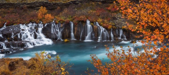
The South Coast is rich in scenic hikes, including routes in Vatnajokull National Park and around many of the region’s waterfalls.
-
North Iceland offers excellent hiking options near Dettifoss Waterfall and around Lake Myvatn.
-
There are also accessible trails near Reykjavik and Keflavik International Airport, including the Keilir Mountain hike.
-
Glacier hiking is a major adventure in Iceland, available in Vatnajokull National Park, on Solheimajokull Glacier, and in several other glacial regions.
Preparing for a Hike in Iceland

Hiking in Iceland, like anywhere else in the world, requires some careful planning, preparation, and a bit of courage before you set off. A few questions you should have the answer to before heading on your journey are:
-
How long is the hike?
-
Have you informed someone of your plans and estimated return time?
-
Do you know the emergency services phone number in Iceland and how you can contact them?
These are just a few crucial questions you should consider before lacing up your hiking boots. Think through every possible scenario, even the unlikely ones, and ask yourself if you're fully prepared to handle whatever comes your way.
Difficulty of the Hike
 Understanding how difficult a hike is will help you choose routes that match your fitness level and experience, and avoid unpleasant surprises on the trail.
Before you commit to any hike in Iceland, look it up online:
-
Total distance – is it a short out-and-back or a long loop?
-
Elevation gain – how much climbing is involved, not just the highest point.
-
Terrain type – paved paths, dirt tracks, lava fields, rocky ground, snow, or river crossings.
-
Typical duration – how long the route takes for an average hiker, including stops.
These four elements give you an idea of what the hike would be like to complete. A quick way to find this information is by checking official park websites, local tourist information offices, or recent trip reports for the specific trail you’re considering.
It’s important to know Iceland’s emergency number (112) and to inform the search and rescue team in Iceland if you plan a difficult hike. You can do this by filling out the form on the SafeTravel website, especially if you’re hiking alone.
What to Pack for a Hike in Iceland
 After you choose your hikes, it’s time to pack the right gear. The items you bring should help you stay warm, safe, and comfortable throughout your hike. Iceland’s weather can change quickly, so being well-prepared is essential.
Essential packing list for all hikes in Iceland:
-
Warm clothes: It's best to wear layers when hiking in Iceland to adjust to the weather.
-
Waterproof and windproof jacket and pants: Essential during the winter months in Iceland.
-
Sturdy hiking boots: Iceland's terrain demands good shoes.
-
Scarf, gloves, and hat: For added warmth and wind protection around your neck and face.
-
Water bottle: It's recommended to bring 0.26 gallons (one liter) for a two-hour hike. More is needed for strenuous hikes, while less is generally required during colder weather.
-
Snacks: Energy gel for more challenging hikes and granola bars for lighter hikes. If you're going on a long trek, bring more food.
Additional packing items for difficult hikes in Iceland:
-
Warm underlayer: Wool leggings, top, and socks as base layers to stay warm.
-
Backpack: Ideally, a durable, waterproof backpack with a rain cover.
-
Map and compass or GPS device: Essential for navigation, especially in remote areas.
-
First aid kit: Including bandages, blister pads, pain relievers, and any personal medications.
-
Trekking poles: These are helpful for stability on uneven terrain and during river crossings.
-
Headlamp or flashlight: with extra batteries, especially important during the long nights in winter.
These lists are not exhaustive, but they will give you an idea of the things you need to keep in mind before venturing to Iceland on your exciting hiking trip.
How To Choose the Best Hiking Trails in Iceland
 Now that you’re fully packed, it's time to explore the best hiking trails in Iceland. With a wide variety of walks and treks in each region, deciding where to hike can be a challenge.
Some visitors attempt the ultimate adventure of hiking across Iceland from the north to the south. This demanding journey takes around 18 to 20 days to complete and is only recommended for incredibly experienced hikers and only safe to do during the summer months.
A more popular and manageable choice is shorter multi-day hikes ranging from one to six days. But, if you’re looking for something less intense, shorter half-day hikes are also an option throughout the country, with several of them close to Reykjavik.
With so many options, there’s a perfect trail for every type of hiker. Read on to explore the best hiking routes in each region of Iceland and find the one that matches your adventure.
The Best Hikes in the Icelandic Highlands
 The Icelandic Highlands offer some of the most striking and remote landscapes in the country. The trails here lead through colorful mountains, black sand deserts, hot springs, and wide open valleys. In this section, you’ll learn how each route offers its own special view of the Highlands.
Landmannalaugar Hiking Trail
 The Landmannalaugar Highland hiking trails are widely known as one of the best treks in Iceland. The area's geothermal activity means Landmannalaugar's rivers and streams are warm and perfect for bathing, which is the ideal way to relax after a hike.
On top of that, the incredible mountains seen during the hike have stunning tones of orange, green, purple, and red, making this region a beauty to witness. These mountain colors have long made Landmannalaugar a must-see for photographers worldwide.
It is important to note that the central highlands, where Landmannalaugar is located, are only accessible during the summer months in Iceland. The area is usually open from late June or early July until the end of September, depending on the weather.
Three Major Hiking Routes in Landmannalaugar:
 Landmannalaugar has many scenic trails, but these three stand out for their colorful landscapes, striking geology, and wide views. They highlight the region’s lava fields, crater lakes, and rhyolite mountains.
1. Laugahraun Lava Field to Brennisteinsalda Mountain Hike
 This hike takes you from the edge of the black Laugahraun Lava Field to the colorful Brennisteinsalda Volcano, which rises about 0.5 miles (0.8 kilometers) tall. Its name comes from the yellow sulfur patches on the mountainside. With red iron, dark volcanic ash, and bright green moss, Brennisteinsalda is often described as one of the most colorful mountains in Iceland.
-
Distance: 4.1 miles (6.6 kilometers)
-
Duration: 2.5–3 hours
-
Difficulty: Moderate
2. Mount Blahnjukur Hike

The hike to the 3,051-foot (940-meter) summit of Mount Blahnjukur, or “Blue Peak,” offers beautiful views. Along the trail, you'll be in awe at the dark blacks and blues of the surrounding lava flows and settled ash.
The mountain sits next to Brennisteinsalda, and on clear days, you can see up to five glaciers from the top. This is one of the best hikes in Iceland for avid landscape photographers.
-
Distance: 3.8–4.1 miles (6.1–6.5 kilometers)
-
Duration: 2.5–3.5 hours
-
Difficulty: Moderate to strenuous
3. Ljotipollur Crater Lake Hike
 The trek to Ljotipollur Crater Lake, or “the ugly puddle” in Icelandic, shows the wide variety of scenery in this area. The name is misleading, as the “puddle” is actually a deep and beautiful lake filled with trout.
The lake is surrounded by sloping red hills that stand out strongly against the dark gravel. The colors change with the light, giving the crater a different look throughout the day.
-
Distance: 8.1 miles (13 kilometers)
-
Duration: 4 hours
-
Difficulty: Moderate
Top Landmannalaugar Hiking Tours
 Given Landmannalaugar's many diverse landscapes and sights, there are numerous hiking tours to enjoy there during your time in Iceland.
-
Scenic 5-Day Hiking Tour from Landmannalaugar to Thorsmork - You’ll cross colorful hills, black sand plains, and river valleys on the way to Thorsmork. Each day ends in a mountain hut with your guide managing navigation and safety.
-
Landmannalaugar Bus Tour with Hiking & Nature Baths from Reykjavik - Enjoy easy to moderate hikes through lava fields and colorful hills before relaxing in the warm natural hot spring. The day also includes visits to waterfalls such as Haifoss and Hjalparfoss.
-
Scenic 6 Day Hiking Tour in Iceland from Landmannalaugar to Thorsmork with Fimmvorduhals day hike - This trek goes beyond the Laugavegur route, leading you across the Fimmvorduhals pass and into Thorsmork with mountain hut stays along the way.
Laugavegur Hiking Trail
 On the Laugavegurinn hiking trail, you will not find shops, cafes, or bars, only quiet paths and beautiful scenery. The name can confuse some visitors because Reykjavik’s main shopping street is also called Laugavegur, but this trail is far into the Highlands.
You’ll first need to choose which direction to hike. You can begin in Landmannalaugar or in Thorsmork. Most people start in Landmannalaugar because the climb is easier and the views become more impressive as you move toward Thorsmork.
Traditionally, the route takes two to four days, with overnight stays at the mountain huts of Hrafntinnusker, Hvanngil, Emstrur, and Alftavatn. There are also huts at the start and end of the hike in Landmannalaugar and Thorsmork.
If you have not booked a hut in advance, it is possible to camp next to the huts. You will need to bring your own tent and camping gear.
The trail passes colorful hills, black sand plains, obsidian areas, river valleys, and glacier views. Several unbridged river crossings are part of the hike, so you’ll need to wade through cold water. Water levels change with weather and time of day, so cross with care.
Most hikers travel to Landmannalaugar on summer highland buses and return from Thorsmork the same way. Super jeep tours and private drivers can also access these areas, but this depends on road and weather conditions. These options are only available during the hiking season.
-
Distance: 34 miles (55 kilometers)
-
Duration: Four days
-
Difficulty: Moderate to difficult
Fimmvorduhals Hiking Trail

If the 34 miles (55 kilometers) of the Laugavegur Trail isn’t long enough, you can extend your adventure by adding the incredible Fimmvorduhals Hiking Trail. This picturesque route lies between the Eyjafjallajokull Volcano and Myrdalsjokull Glacier.
The trail begins in Thorsmork and continues for 14 miles (22 kilometers) toward Skogar. Along the way, it passes waterfalls, snowfields, and volcanic craters created during the 2010 eruption.
If you plan to hike only the Fimmvorduhals route, many hikers choose to start in Skogar. This direction follows the long line of waterfalls along the Skoga River. Hikers will climb up to 3,300 feet (1,000 meters) on the route. The full hike usually takes 10–12 hours to complete.
Some people split the journey into two days and stay overnight in a mountain hut. This trail is challenging and best for hikers with good fitness and experience, as mountain weather can change quickly.
-
Distance: 16 miles (25.7 kilometers)
-
Duration: One to two days
-
Difficulty: Difficult
Book your mountain huts through the Iceland Tour Association and get Highland hiking bus passes to and from your starting and ending points.
If you have a small rental car, you can leave it at Hvolsvollur town and join a super jeep day tour to Thorsmork, which is necessary to cross unbridged rivers accessible only by 4x4 vehicles. Once in Thorsmork, you can enjoy shorter hikes in the area before starting the main trail.
The Best Hikes in the Westfjords of Iceland
 Discover the hidden gems of Iceland’s Westfjords and explore some of the best hikes in this quiet and remote region. These trails offer coastal views, steep cliffs, and peaceful landscapes, perfect for hikers looking for solitude and untouched nature.
Hiking the Hornstrandir Nature Reserve
 The Hornstrandir Nature Reserve in the Westfjords is one of Iceland’s most isolated regions. It is known for its high bird cliffs, lack of roads and services, and healthy population of arctic foxes.
Hiking in the Westfjords gives you the chance to experience Icelandic nature in its most untouched form. The landscape is quiet, dramatic, and peaceful, offering an adventure unlike anywhere else in the country.
There are no shops, roads, or permanent residents in this area. Camping is the only option for overnight stays, and you must bring all your food, gear, and supplies with you. Overnight stays are only allowed at marked campsites, and some locations require advance registration.
There is no mobile signal in most areas, and the trails are not marked, so good navigation skills are important. Weather can change quickly, and fog is common near the cliffs, so hikers should move carefully and stay well back from the edges.
Arctic foxes are often seen along the trail and near campsites. They may come close out of curiosity, but you should never feed them and should always keep a respectful distance.
How to Reach Hornstrandir Nature Reserve
 To reach Hornstrandir Nature Reserve, you must take a boat from Isafjordur town or the small fishing village of Bolungarvik. Most travelers arrive at Hesteyri, which is the main starting point for exploring the reserve.
If you plan to visit this remote region, book accommodations in the Westfjords in advance or join a guided hiking tour with an experienced local guide.
Recommended Hornstrandir Hiking Trails and Itinerary
 These trails offer a three-day journey through one of Iceland’s most remote and beautiful areas. This route highlights the region’s main sights and makes the most of your time in Hornstrandir.
Day 1: Hesteyri to Hloduvik
Embark on a 9-mile (15-kilometer) hike from the harbor at Hesteyri to the bay of Hloduvik. This takes around four to six hours, and the bay has several campsites where you can stay overnight.
Day 2: Skalarkambur Mountain and Hornvik Bay
Climb the steep slopes of Skalarkambur Mountain for wide views over the fjords. After crossing the mountain, continue to Rekavik Bay and Hornvik Bay to set up camp for the night.
Optional: Hike a little farther to the old farm at Horn for another campsite. This brings you closer to Hornbjarg, one of the most famous cliffs in Iceland.
Hornbjarg is known for its steep 1,640-foot (500-meter) drop into the ocean and thousands of nesting seabirds. Fog is common here, so follow marked safe paths and stay well away from the cliff edges.
Day 3: Hornvik Bay to Veidileysufjordur
Hike over a mountain pass from Hornvik Bay into the fjord, Veidileysufjordur. From here, you'll take a boat back to the mainland. You can arrange a reservation at Tjoruhusid, a famous restaurant in Isafjordur, and we recommend trying a fish dinner.
The Best Hikes in the Eastfjords of Iceland
 Explore the peaceful beauty of Iceland’s Eastfjords with this selection of great hiking routes. This region is known for quiet fishing villages, dramatic fjords, colorful mountains, and long, steady trails that feel far from the crowds.
Viknaslodir Hiking Trails in the Eastfjords
 The Viknaslodir area is often called “The Trails of the Inlets.” Spending five to ten days exploring this region is recommended, although many hikers choose a shorter five-day highlight route.
The full trail is around 93.2 miles (150 kilometers) long and is considered one of the best multi-day hikes in Iceland. Expect dramatic mountains, seafront cliffs, quiet beaches, colorful rhyolite hills, green valleys, and bright blue fjord waters.
Because this is a remote part of Iceland, services are limited. Weather can change quickly, and fog is common in the mountains, so it’s important to check conditions and be comfortable navigating lightly marked trails.
This is a summer-only trek. Roads leading to Borgarfjordur Eystri, one of the best towns to visit in East Iceland, may be closed in winter due to heavy snow, and the mountain huts along the trail are unavailable.
-
Distance: 93.2 miles (150 kilometers)
-
Duration: Five to ten days
-
Difficulty: Moderate to difficult
Borgarfjordur Eystri to Seydisfjordur Hike

This scenic route covers 34.1 miles (55 kilometers) between the villages of Borgarfjordur Eystri and Seydisfjordur. Hikers will enjoy views of the North Atlantic, walk through mountain passes, and pass small farmsteads along the way.
Because this route crosses high terrain, weather and visibility can shift quickly. Most travelers complete this hike in three to four days, staying in huts or designated campsites along the trail.
-
Distance: 34.1 miles (55 kilometers)
-
Duration: Three to four days
-
Difficulty: Difficult
The Best Hikes in South Iceland
 Discover the stunning landscapes of South Iceland and the best hikes in this famous region. From glacier valleys to volcanic terrains, the trails on the South Coast offer an unforgettable journey through some of Iceland’s most breathtaking natural landscapes.
Svartifoss Waterfall Hike in Vatnajokull National Park

In Vatnajokull National Park, you’ll find Svartifoss Waterfall, also known as the “black falls” for its dark basalt columns. From the visitor center at Skaftafell Nature Reserve, it's a moderately easy hike uphill to the waterfall and downhill, returning the same way. This is the easiest hike in the national park, also known as the Waterfalls Trail.
Because of the spray and wet rocks, the area near the waterfall can be slippery, especially after rain or in early summer when the snow melts. The path is open year-round, but ice may form in winter, so spikes or good winter shoes may be needed.
-
Distance: 2 miles (3.2 kilometers)
-
Duration: One hour
-
Difficulty: Easy to moderate
Skogafoss Waterfall Hike
 Skogafoss is one of the best-known waterfalls in Iceland and also part of the Fimmvorduhals trails. Since it's one of the first waterfalls you encounter, you can choose to hike there as a short out-and-back trip. The waterfall is one of the most popular attractions on the South Coast, with a fall of over 197 feet (60 meters) tall and 82 feet (25 meters) wide.
The area can be windy and wet from the waterfall spray, so waterproof shoes are recommended. Skogafoss is close to the Ring Road and often crowded in summer, so visiting early or late in the day provides the best experience.
-
Distance: 4.2 miles (6.8 kilometers)
-
Duration: 45 minutes to 1.5 hours
-
Difficulty: Moderate
Seljalandsfoss Waterfall to Gljufrafoss Waterfalls Hike

This is an easy hike in South Iceland, near the popular Thosmork area. The trail connects the Seljalandsfoss Waterfall to the hidden Gljufrabui Canyon.
The water that feeds Seljalandsfoss comes from the famous Eyjafjallajokull Glacier, and there's a small cave behind it that you can walk into. With a drop of 200 feet (60 meters), be prepared to get wet if you decide to enter the cave.
The path around Seljalandsfoss is often very wet, and the rocks inside the cave can be slippery. Waterproof shoes and rain jackets are helpful here, especially if you plan to walk behind the waterfall.
-
Distance: 1.19 miles (1.9 kilometers)
-
Duration: 30 minutes to one hour
-
Difficulty: Easy
Mulagljufur Canyon Hike
 Mulagljufur Canyon is one of South Iceland’s most striking hidden valleys. The trail passes steep cliffs and hanging glaciers, offering sweeping views toward the mountains above the canyon.
The route climbs toward viewpoints overlooking Mulafoss and Hangandifoss Waterfalls. These tall cascades drop into the gorge, framed by the distant peaks of Oraefajokull.
Parts of the path can be steep or muddy, especially after rain. Sturdy footwear, layered clothing, and enough water are important for this longer trail.
-
Distance: 3.7 miles (6 kilometers)
-
Duration: 2.5 to 4 hours
-
Difficulty: Moderate to challenging
The Best Hikes in North Iceland
 Uncover the diverse beauty of North Iceland with this selection of great hiking routes. From volcanic craters to quiet fjords, the trails in this region offer a peaceful blend of dramatic landscapes and untouched nature.
Dettifoss Waterfall to Selfoss Waterfalls Hike
 Dettifoss and Selfoss are two of the most powerful waterfalls in Iceland and are located in Vatnajokull National Park near the town of Husavik in Northeast Iceland. Selfoss sits upstream from Dettifoss and can be viewed from both the east and west sides of the river.
The east side offers the best view of Selfoss, but the gravel road is often closed outside of summer. The west side is easier to reach on a paved road and has a shorter walk. Both routes start from marked parking areas and can visit both sides in one day.
These waterfalls are popular in summer, so visiting early or later in the day gives a quieter experience. Toilets and basic facilities are available on the west side during the main season.
-
Distance: 2.2 miles (3.5 kilometers)
-
Duration: One to two hours
-
Difficulty: Easy
Lake Myvatn Area Hiking Tours
 The Lake Myvatn region in North Iceland is filled with hiking opportunities, volcanic landscapes, geothermal areas, and peaceful nature. These tours highlight some of the best ways to explore the area.
-
Super Jeep Tour to Askja Caldera & Holuhraun Lava Field with Transfer from Myvatn - Join this Super Jeep tour from Lake Myvatn to Askja Caldera and Holuhraun Lava Field. Hike among volcanic craters and lava formations with Myvatn transfers included.
-
5-Hour Myvatn Hiking & Myvatn Nature Baths Combo Tour from Reykjahlid Town - Go on a hiking adventure around the ethereal Lake Myvatn and relax in the waters of a geothermal bath during this exciting tour.
-
Incredible 8-Hour Sightseeing Tour on Lake Myvatn and Godafoss Waterfall from Akureyri - During this memorable sightseeing tour, you'll have the opportunity to hike, cave, bathe, and more in the stunning Lake Myvatn region.
The Best Hiking Trails Around the Golden Circle
 Discover the best hiking trails around Iceland's iconic Golden Circle, where geothermal wonders, majestic waterfalls, and breathtaking landscapes await. These trails offer a deeper connection to this famous region's natural beauty and unique features.
Gullfoss Waterfall Hike
 Gullfoss is one of Iceland’s top attractions and a highlight of the Golden Circle route. Even in winter, 358 cubic feet (109 cubic meters) of water rush over the falls each second, creating a dramatic sight. The trail is short and easy, with paths leading close to the viewing platforms.
Because of the spray from the waterfall, the ground can be slippery, especially in winter when ice forms on the path. Gullfoss is very popular, so visiting early or late in the day offers a quieter experience. Parking is close to the trail and easy to access year-round.
-
Distance: 1.3 miles (2.1 kilometers)
-
Duration: 30 minutes to one hour
-
Difficulty: Easy
Oxararfoss Waterfall Hike in the Thingvellir National Park

In Thingvellir National Park, most visitors walk through the wide Almannagja Gorge. The paths are well-maintained and mostly flat, with wooden walkways that are even wheelchair-accessible in many sections. At the top of the gorge, you’ll see Thingvallavatn, Iceland’s largest lake.
The scenic trail to Oxararfoss Waterfall is easy to follow and suitable for most hikers. Because Thingvellir sits in a rift valley between two tectonic plates, the landscape is full of interesting rock formations and narrow fissures. The area can be busy during midday, so visiting earlier helps avoid crowds.
-
Distance: 2.6 miles (4.2 kilometers)
-
Duration: One to two hours
-
Difficulty: Easy
Hiking to Reykjadalur Hot River Valley

Reykjadalur, or “Steam Valley,” is a popular hiking area near the Golden Circle. The trail leads through a geothermal valley filled with steam vents, hot pools, and mountain views. At the end of the hike, you can bathe in a warm natural river.
The trail is easy but includes steady uphill sections and can be windy or muddy, especially in early spring or after rain. Stay on marked paths, as the ground near hot springs can be unstable and hot. Parking is available at the trailhead, and the route is well marked.
-
Distance: 4.3 miles (7 kilometers)
-
Duration: Two hours each way (Four hours total)
-
Difficulty: Easy
The Best Hiking Trail in the Snaefellsnes Peninsula
 Explore the best hiking trail in the Snaefellsnes Peninsula, where dramatic cliffs, volcanic craters, and sweeping coastal views combine to create a hiker’s paradise. These hiking spots reveal the stunning and diverse landscapes of one of Iceland's most picturesque regions.
Arnarstapi to Hellnar Hike in the Snaefellsjokull National Park

In Snaefellsjokull National Park, a coastal trail connects the villages of Arnarstapi and Hellnar. The path follows sea cliffs and lava formations, passing arches, basalt columns, and glacier views. The terrain is mostly flat, with some narrow or uneven sections.
Parking is available in both Arnarstapi and Hellnar, and the trail is easy to follow. If you don't have transport at the other end, you'll need to walk back the same way. Nesting seabirds are common in summer, so stay on marked paths to protect the coastline.
-
Distance: 1.9 miles (3.1 kilometers)
-
Duration: One hour
-
Difficulty: Easy
The Best Hiking Trails on the Reykjanes Peninsula

Almost everyone arriving in Iceland will visit the Reykjanes Peninsula at one point or another during their trip. After all, this region is home to Keflavik International Airport, the world-famous Blue Lagoon, the Bridge Between Continents, the Krysuvik Geothermal Area, and numerous other nature attractions and towns.
The impressive and continuous volcanic eruptions in the Reykjanes Peninsula brought this region into the global spotlight in 2021. These eruptions have shaped and changed the landscape in the region and are something to keep in mind while planning a hike.
The Reykjanes Peninsula is an option for those looking to hike relatively close to Reykjavik. The peninsula landscape is dark, diverse, cragged, and full of opportunity, be it the great areas of geothermal activity, the hidden cave networks, the towering mountains, or the scenic coastlines.
Reykjanes Eruption Sites Hike
 The eruption areas within the Fagradalsfjall volcanic system offer some of the most striking terrain on the Reykjanes Peninsula. Trails take hikers past the 2021 Geldingadalir lava, the 2022 Meradalir flows, and the 2023 Litli-Hrutur crater.
Access conditions change frequently because of ongoing geological activity. Routes may shift or close, and the ground can be uneven or unstable. Hikers should only visit in stable weather and follow all marked paths and safety guidance.
-
Distance: Varies by active trail
-
Duration: One to four hours
-
Difficulty: Moderate to challenging
Keilir Mountain Hike

One of the most popular and accessible hikes on the Reykjanes Peninsula is climbing the summit of the cone-shaped Keilir Mountain. The mountain peaks at 1,280 feet (390 meters), with steep, sweeping sides, which can be challenging for underprepared hikers.
Access roads to Keilir are easy to reach, but some tracks can be rough depending on conditions. Strong winds and low visibility are common in this area, so hikers should only attempt the summit in clear weather and stay on the marked route.
-
Distance: 4.4 miles (7.1 kilometers)
-
Duration: Two to three hours
-
Difficulty: Moderate
Hafnir Town to Hafnaberg Sea Cliffs Hike
 Another hiking route runs from the small Hafnir fishing settlement to the impressive cliffs of Hafnaberg. The cliffs are a favorite amongst birdwatchers, and visitors can expect to see nesting razorbills, fulmars, guillemots, and kittiwakes, among other local birdlife.
The cliffs of Hafnaberg are also a well-known observation point for spotting whales, dolphins, and seals swimming off the Reykjanes coastline. Remember your safety while visiting the cliffs, as the rocks are unstable, so keeping a few meters back is best to prevent accidents.
Those who go for the Hafnir-Hafnaberg hike will also have the opportunity to see a significant attraction of the Reykjanes Peninsula: the Bridge Between the Continents. It’s a 49.2-foot (15-meter) walkway between the exposed North American and Eurasian tectonic plates. On one side of the bridge, a plaque reads "Welcome to America," and on the other, "Welcome to Europe."
-
Distance: 8 miles (12.8 kilometers)
-
Duration: 3–4 hours
-
Difficulty: Easy
The Best Hiking Trails Close to Reykjavik
 Explore the best hiking trails close to Reykjavik, where stunning nature and diverse landscapes are just a short drive away. From scenic hills to tranquil lava fields, these trails offer the perfect escape into Iceland's natural beauty without venturing far from the city.
Hiking Esjan Mountain
 Esjan is the closest mountain to Reykjavik and one of the most popular day hikes in the area. You can reach the trailhead by car or by taking a city bus to the stop called “Esjuraetur – Hiking Center.”
The mountain rises to 3,000 feet (914 meters), and the trail becomes demanding near the top, where ropes and steps help hikers through the steeper sections. Those who prefer an easier option can hike to the Steinn viewpoint or choose the popular route to Thverfellshorn, which reaches 2,560 feet (780 meters).
In winter, climbing to the summit is not recommended except for experienced hikers with the right gear, as snow and ice can create avalanche risks. Weather conditions should always be checked before starting, even in summer, as the mountain is exposed to strong winds.
-
Distance: 8.7 miles (14 kilometers)
-
Duration: Three to four hours
-
Difficulty: Easy to difficult (depending on the chosen route)
Hiking to Helgafell Mountain

Helgafell lies just south of Reykjavik near the town of Hafnarfjordur and is a favorite hike among locals. Standing at 1,152 feet (351 meters), it is a good choice for families and those wanting a shorter, scenic trip close to the city.
Most hikers begin at Kaldarbotnar, where the parking area and trailhead are located. The first part of the hike crosses flat lava fields before the trail gently climbs the northeast side of the mountain. The summit offers views over Reykjavik, Hafnarfjordur, and the Reykjanes Peninsula.
The trail is exposed with no shade, so windproof clothing is useful. In winter, the path can become icy, and hikers should take extra care on steeper sections.
-
Distance: 6.5 miles (10.5 kilometers)
-
Duration: Three to four hours
-
Difficulty: Moderate
Hiking to Glymur Waterfall

Glymur is Iceland's second-tallest waterfall, after the Morsarfoss Waterfall, and offers a more accessible hike. To reach the trailhead, you must drive approximately 31.6 miles (50.8 kilometers) from Reykjavik to the base of the beautiful Hvalfjordur Fjord.
The hike includes walking through a cave, crossing a river on a large log bridge (available only in summer), and climbing a steep mountainside with impressive views. If the full climb feels too hard, you can stop after about an hour and still enjoy a beautiful view of the canyon.
The right side of the river offers the best views of the waterfall. In early summer or after heavy rain, water levels may be too high to complete the loop, so hikers should turn back the same way. The cliffs near the top have no railings, so caution is essential, and this trail is not recommended for small children.
-
Distance: 4.3 miles (6.9 kilometers)
-
Duration: About three hours
-
Difficulty: Moderate
Best Glacier Hikes in Iceland

Glacier hiking in Iceland offers an unforgettable adventure for outdoor enthusiasts. Explore the unique landscape from Iceland's glaciers, where you'll walk across ice formations, crevasses, and frozen terrain. Guided glacier hiking tours provide essential safety gear and expert knowledge, making glacier hiking accessible even for beginners.
Hvannadalshnukur Hike in Vatnajokull National Park
 A glacier ascent to the summit of Hvannadalshnukur requires excellent fitness, strong endurance, and guidance from an experienced mountain guide. Hikers wear a harness and travel roped together due to deep crevasses along the route. Previous glacier experience is recommended.
Hvannadalshnukur stands at 6,923 feet (2,110 meters) and is Iceland’s highest peak. It rises from the Oraefajokull Volcanic Glacier and involves a steep elevation gain across hard ice and snow. This challenging hike is attempted only in late spring and summer, when conditions are stable.
-
Distance: About 18 miles (28.6 kilometers)
-
Duration: 12 to 15 hours
-
Difficulty: Difficult
Svinafellsjokull Glacier Hike

Svinafellsjokull, an outlet glacier of Vatnajokull, is one of the most dramatic glacier landscapes in Iceland. It features sharp ridges, deep crevasses, and sweeping ice formations. The high elevation offers views of neighboring glaciers and mountains.
Due to slope instability near the glacier’s edges, hiking here is only done with certified guides who access safe, monitored areas. Winter is a popular time to visit, as the ice appears bright blue and ice caves may be visible. Many travelers explore this area on a top-rated glacier hiking tour on Vatnajokull, which follows short but scenic routes
-
Distance: Usually 1–2 miles (2–3.5 kilometers)
-
Duration: 3 to 5 hours
-
Difficulty: Moderate
Falljokull Glacier Hike

The Falljokull Glacier is called the "falling glacier" because its massive ice falls make for a stunning sight. It's an outlet of the Oraefajokull Glacier in South Iceland, which itself is part of the larger Vatnajokull Glacier.
Guided glacier hikes on Falljokull take you through crevasses, ice ridges, and frozen landscapes. Because this glacier moves quickly, tours adjust their routes based on daily conditions. The hike requires a good level of fitness due to uneven terrain.
-
Distance: Usually 1–3 miles (1.5–5 kilometers)
-
Duration: 3 to 5 hours
-
Difficulty: Difficult
Solheimajokull Glacier Hike
 The Solheimajokull Glacier in South Iceland is a closer option for those coming from Reykjavik and is the most popular glacier hiking spot for beginners. It is close to the infamous Eyjafjallajokull Volcano, and glacier hikers might sometimes get a glimpse of it.
The hike is memorable due to the lack of tall mountains around the glacier, which provides an incredible view. The nature of the ice means ice climbing is also possible on this glacier. You can choose this glacier hiking tour to Solheimajokull Glacier, or if you are feeling adventurous, combine it with ice climbing tours.
-
Distance: Varies by tour
-
Duration: 2 to 4 hours
-
Difficulty: Easy to Moderate
-
Visit our list of Glacier Tours in Iceland for other glacier activities.
Other Glacier Hiking Experiences
 There's no shortage of glacier hiking experiences to have in Iceland. If you're searching for a more guided experience, check out these glacier hiking tours.
-
Popular Glacier Hiking Tour in Skaftafell - During this glacier hiking adventure, you'll explore the stunning outlet glacier of Europe's largest glacier, Vatnajokull.
-
Fantastic 2.5-Hour Easy Glacier Hike & Sightseeing Discovery Tour on Solheimajokull - This glacier hike of Solheimajokull is perfect for beginners and a great way to see beautiful formations, crevasses, and sinkholes.
-
The 5-Hour Skaftafell Glacier Hiking Tour - After traveling to Skaftafell Nature Reserve, you'll join a guide and a small group on an enjoyable 5-hour glacier hiking experience.
Additional Hiking Spots in Iceland

The regions mentioned above are only a small sample of the many hiking opportunities you can find across Iceland. Almost everywhere you go, there are scenic trails, short nature walks, or viewpoints that reveal a different side of the country’s landscapes.
The area around Lake Myvatn offers easy access to volcanic features such as the Dimmuborgir Lava Field and the Hverfjall Volcano. These trails are known for their unusual formations, clear paths, and family-friendly routes.
South Iceland and the southern coastline of the Eastfjords also offer a wide range of short hikes, from sea cliffs and black sand beaches to quiet mountain valleys. These areas are great for travelers who want peaceful fjord views and gentle coastal walks.
Additionally, the Snaefellsnes Peninsula and Highland areas like Kerlingarfjoll Mountain Range and Hveravellir are well worth exploring. These regions feature colorful mountains, hot springs, and striking volcanic landscapes, especially in summer when the Highland roads are open.
Frequently Asked Questions About Hiking in Iceland
 If you want to be extra-prepared for your upcoming hike, make sure to check out these helpful frequently asked questions.
Is it safe to hike in Iceland?
Hiking in Iceland is generally safe for well-prepared travelers who respect the environment and follow marked paths. Sudden weather shifts and rugged terrain can pose risks, so make sure to listen to local advice and look up current forecasts. Additionally, many Iceland hiking trails are remote, making good planning essential for a safe experience.
How difficult are glacier hikes?
Glacier hikes in Iceland vary in difficulty, with some routes accessible to beginners and others demanding more technical skills. These icy adventures offer a unique way to experience Iceland trekking beyond traditional mountain paths.
Are crampons needed for hiking in Iceland?
Crampons are incredibly useful for glacier tours and winter hiking trails in Iceland, where ice and snow cover the ground. Wearing them when trekking Iceland’s higher elevations can add an extra layer of safety, so it's a good idea to have them if a guide doesn't supply them. During summer, many non-glacier Iceland trails do not require them unless conditions are icy.
Can I take lava rocks I find on hikes with me?
Taking lava rocks or any natural souvenirs from hikes in Iceland is discouraged and often prohibited to protect the fragile environment. Hiking is all about experiencing untouched landscapes, not removing parts of them. Leaving rocks behind helps preserve the integrity of beautiful hiking trails Iceland is known for, so it's best to take a picture instead.
Is a permit needed to hike in Iceland?
Although day hikes in Iceland do not require a permit, you'll need to book huts on the trails if you want to stay in them. Planning ahead for your Iceland hike helps avoid surprises and keeps your adventure smooth and unimpeded.
Experience the Ultimate Hiking in Iceland
 Don't wait any longer to start planning your hiking experience in Iceland and explore the beauty of the land of fire and ice for yourself. With such diverse landscapes and scenery, you're sure to find hiking trails that match your skill level and personal preferences.
Did you enjoy our article about hiking in Iceland? What hiking routes would you want to experience during a visit? Please feel free to share any thoughts or questions you might have in the comment section below!

I’m Icelandic but grew up abroad, and returned as an adult to reconnect with my roots. I have a soft spot for scenic drives, peaceful geothermal spas, and the little details that turn a good trip into a great one. Here, I share all my best tips with you!