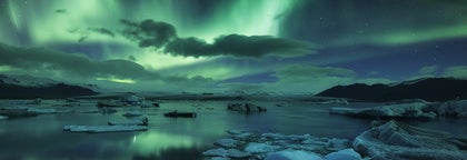
Best Glacier Tours in Iceland
Discover the largest selection of glacier tours in Iceland. Witness the magic of Iceland's glaciers and explore ice formations and surreal blue ice caves.
Find a unique experience
Select starting location
Select dates
Starting dateFinal date
Add travelers
1 traveler
Not sure where to start? Check out our guide to Glaciers in Iceland
Glacier Tours
Refine the results by using the filters
Sort by: Popular


We offer so much more
Explore an unequalled wealth of tours and packages
Frequently asked questions
What is the best glacier tour in Iceland?
The best glacier tour in Iceland is this glacier hiking tour in Skaftafell, rated 4.9 out of 5 stars by more than 220 travelers. This small group, five-hour excursion takes you to an impressive glacier in Skaftafell Nature Reserve, where you’ll witness dramatically carved landscapes and impressive ice formations and crevasses. This tour costs around 160 USD.
Another highly rated tour is this three-day northern lights tour of Iceland’s Golden Circle & South Coast with ice caving & glacier hiking, rated 4.8 out of 5 stars with more than 940 reviews. This tour not only brings you to iconic Icelandic landscapes but also lets you explore glaciers and landscapes. This adventure is approximately 950 USD.
Another highly rated tour is this three-day northern lights tour of Iceland’s Golden Circle & South Coast with ice caving & glacier hiking, rated 4.8 out of 5 stars with more than 940 reviews. This tour not only brings you to iconic Icelandic landscapes but also lets you explore glaciers and landscapes. This adventure is approximately 950 USD.
Is it worth it to take a glacier tour in Iceland?
Absolutely, taking a glacier tour in Iceland is undeniably worth it. The tours provide a unique opportunity to witness the awe-inspiring beauty of Iceland's glaciers, offering a once-in-a-lifetime experience amid breathtaking natural landscapes.
Whether exploring ice caves, marveling at colossal ice formations, or learning about the geological wonders from knowledgeable guides, the adventure promises unforgettable memories and a deep connection with the pristine Arctic environment.
Whether exploring ice caves, marveling at colossal ice formations, or learning about the geological wonders from knowledgeable guides, the adventure promises unforgettable memories and a deep connection with the pristine Arctic environment.
What is the cheapest glacier tour in Iceland?
The cheapest glacier tour in Iceland is the easy 1.5 hour glacier hiking tour on Solheimajokull with a certified guide, which is around 87 USD. This tour lets you encounter the wonderful world of glaciers and is suitable for hikers of any fitness level.
Another very affordable tour is this best price Solheimajokull glacier hiking tour, which is around 97 USD. This tour starts at the foot of Solheimajokull glacier, brings you to impressive ice formations, and lets you drink glacial water.
Another very affordable tour is this best price Solheimajokull glacier hiking tour, which is around 97 USD. This tour starts at the foot of Solheimajokull glacier, brings you to impressive ice formations, and lets you drink glacial water.
Can I go on a glacier hike by myself in Iceland, or do I need a tour?
No, you cannot hike up a glacier in Iceland by yourself. Glaciers can be very dangerous places and the proper equipment and experience are needed to safely navigate them. Your guide on your glacier tour in Iceland will make sure it's both a safe and memorable experience. Those who still want a glacier experience in Iceland without the trek can also consider a tour of Jokulsarlon glacier lagoon.
What is there to see on top of a glacier in Iceland?
The summit of an Icelandic glacier will provide for ever-changing sceneries of ice formations, cracks, and crevasses. The white snow is often streaked with black volcanic ash, but the views of the surrounding landscapes depend on the glacier. For example, Svinafellsjokull glacier is part of the highest mountain range in Iceland, and if you ascend the ice-cap on a clear day, you might see the magnificent Hvannadalshnukur, the country's highest peak.
How long do glacier hiking tours in Iceland typically last?
The duration of glacier hiking tours in Iceland can vary, with shorter tours lasting around 2-3 hours and more extended, full-day excursions taking up to 8 hours or more. Multi-day tours are also available for more in-depth exploration of Iceland's glaciers and surrounding landscapes.
What is the average group size for glacier hiking tours in Iceland?
The average group size for glacier hiking tours in Iceland can vary depending on the tour but typically ranges from 8 to 16 participants per guide. Smaller groups allow for a more personalized experience and better attention from the guide, such as this small group 3-hour glacier hike on Fjalljokull glacier.
What should I wear for glacier hiking tours in Iceland?
You should wear sturdy, waterproof hiking boots that cover your ankles. No high heels, open shoes, or sneakers. Additionally, you should also bring clothing appropriate to Iceland's environment, including an insulating layer, a wind- and rainproof jacket, warm socks, a cap, and perhaps sunglasses. See this complete guide to hiking in Iceland for more information.
Can the elderly join glacier hiking tours in Iceland?
Yes, the elderly are welcome to join but keep in mind that a glacier hike in Iceland can be physically demanding, so it depends on the physical condition of each individual. The easiest glacier hike on Solheimajokull takes around two hours, with only minor elevation, making it a great choice for families and travelers wanting a more relaxed experience.
What glaciers are popular for hiking tours in Iceland?
Popular glaciers for hiking tours in Iceland include Vatnajokull, the largest glacier in Europe; Solheimajokull, located on the South Coast; Svinafellsjokull, a part of Vatnajokull National Park; and Langjokull, Iceland's second-largest glacier.
Where is Skaftafell Nature Reserve in Iceland?
Skaftafell Nature Reserve in Iceland is a sub-arctic oasis nestled beneath Vatnajokull, Europe's largest glacier. Situated between jet-black sand expanses and creeping glacier tongues, Skaftafell Nature Reserve is famed for its rich flora and contrasting landscapes. The area features a network of hiking trails that take you to natural features such as the waterfalls of Svartifoss and Hundafoss. Multiple glacier hiking tours depart from Skaftafell year-round, but the area is also the perfect base camp for mountaineers seeking to climb Iceland’s highest peak, Hvannadalshnukur.
What is the difference between glacier tours onto Svinafellsjokull glacier and onto Solheimajokull glacier?
Solheimajokull is one of the closest glaciers to Reykjavik and can easily be accessed on a day tour. Svinafellsjokull is an outlet of Vatnajokull, Europe's largest glacier, and because it is much farther away, a glacier hike on Svinafellsjokull cannot be done on a day tour from the capital. Glacier hiking excursions on Svinafellsjokull normally depart from Skaftafell nature reserve.
Icelandic weather can be unpredictable. Will my glacier walk be cancelled if it rains?
Travelers should be prepared for most weather conditions by bringing with them the right clothing. Many glacier tours in Iceland will proceed in the event of light rain. However, in the event of worse weather, the glacier tour may be canceled. If the tour is canceled due to unfavorable weather conditions, your operator will contact you and you will receive a full refund or a rescheduled tour. Contact us at info@guidetoiceland.is if you have any questions.
When is the best time for glacier hiking tours in Iceland?
Glacier hiking tours in Iceland are available year-round, with each season offering unique experiences. However, the peak season for glacier hiking is from May to September when the weather is milder, and daylight hours are longer.
Are glacier hiking tours suitable for beginners?
Many glacier hiking tours cater to beginners, with experienced guides providing instruction and assistance throughout the hike. Some tour operators also offer different difficulty levels, allowing you to choose a tour that matches your experience and fitness level. Read the tour description carefully to gather the experience level needed for the glacier hike.
What equipment is needed for a glacier hiking tour in Iceland?
Tour operators will provide essential glacier hiking equipment, such as crampons, helmets, harnesses, and ice axes. You should wear warm, waterproof clothing, including a waterproof and windproof jacket, thermal layers, hiking boots, gloves, and a hat.
Are there any age or fitness restrictions for glacier hiking tours in Iceland?
Glacier hiking tours generally require a moderate level of fitness and may have age restrictions, usually with a minimum age of 8-12 years. Some tours may also have weight and height requirements. Always check the tour description before booking to ensure you meet the requirements.
Is it safe to go glacier hiking in Iceland?
Glacier hiking in Iceland is considered safe when led by experienced guides and following proper safety precautions. Tour operators are knowledgeable about current glacier conditions and will provide the necessary equipment and safety instructions to ensure a safe and enjoyable experience.
Do I need to book a glacier hiking tour in Iceland in advance?
It's recommended to book glacier hiking tours in Iceland in advance, particularly during the peak season (May to September), to secure your spot and avoid disappointment.


Install Iceland’s biggest travel app
Download Iceland’s biggest travel marketplace to your phone to manage your entire trip in one place
Scan this QR code with your phone camera and press the link that appears to add Iceland’s biggest travel marketplace into your pocket. Enter your phone number or email address to receive an SMS or email with the download link.